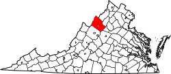
Cootes Store, Virginia

Last updated

Cootes Store
Cootes Store1.jpg
Cootes Store in 1895
USA Virginia location map.svg
Red pog.svg
Cootes Store
Location in Virginia
Usa edcp location map.svg
Red pog.svg
Cootes Store
Cootes Store (the United States)
Coordinates: 38°38′18″N78°51′4″W / 38.63833°N 78.85111°W / 38.63833; -78.85111
CountryFlag of the United States.svg  United States
State Virginia
County Rockingham County
Elevation
330 m (1,083 ft)

Cootes Store is an unincorporated community in Rockingham County, Virginia, United States. Located in the Shenandoah Valley, it is situated north of Harrisonburg, south of Bergton, and west of Timberville. The border with West Virginia is nearby, as is the edge of George Washington National Forest. [1] Cootes Store is within a gorge where the North Fork Shenandoah River breaks, at the crossroads of Route 613 and Route 259.

Contents

Etymology

The name of the community is derived from that of Samuel Cootes, [2] owner of the eponymous store. He was a prominent local landholder and member of the community, who later served as a member of the Virginia House of Delegates. [2] [3]

History

Isolated villages needed a general supply store, and Cootes supplied that need for two Virginia towns, Cootes Store and Dovesville (renamed Bergton). [4] Located a mile from Brocks Gap, Cootes Store was a rendezvous point for working men meeting on a Saturday afternoon, given its strategical location. [5] Historic photographs reveal that from earlier times it was always an agricultural community with cowboys. In 1870, merchants began using the Shenandoah River from Brock's Gap to Cootes Store for transporting people and goods. [6] By 1900, Cootes Store had a one-room public school. [7]

In 1936, Cootes Store and Bergton were affected by the Great Flood. At worst, the water was four feet deep and washed away many barns, cottages and other features in the area. [8]

Today, the community consists of many barns.

Transportation

Around 1880, a covered bridge was built over an older bridge at Cootes Store to cross the river's North Fork, placing the road at a higher level. [9] Like other towns along the Shenandoah River, Cootes Store also boasted a swinging bridge. [10]

Evergreen, 1921 Cootes Evergreen Magazine 1921.jpg
Evergreen, 1921

Related Research Articles

<span class="mw-page-title-main">Rockingham County, Virginia</span> County in Virginia, United States

Rockingham County is a county located in the U.S. state of Virginia. As of the 2020 census, the population was 83,757. Its county seat is the independent city of Harrisonburg.

<span class="mw-page-title-main">Elkton, Virginia</span> Town in Virginia, United States

Elkton is an incorporated town in Rockingham County, Virginia, United States. It is included in the Harrisonburg Metropolitan Statistical Area. The population was 2,762 at the 2010 census. Elkton was named for the Elk Run stream.

<span class="mw-page-title-main">Mount Jackson, Virginia</span> Town in Virginia, United States

Mount Jackson is a town in Shenandoah County, Virginia, United States. The population was 1,994 at the 2010 census.

<span class="mw-page-title-main">Shenandoah Valley</span> Region of Virginia and West Virginia

The Shenandoah Valley is a geographic valley and cultural region of western Virginia and the Eastern Panhandle of West Virginia in the United States. The valley is bounded to the east by the Blue Ridge Mountains, to the west by the eastern front of the Ridge-and-Valley Appalachians, to the north by the Potomac River and to the south by the James River. The cultural region covers a larger area that includes all of the valley plus the Virginia highlands to the west, and the Roanoke Valley to the south. It is physiographically located within the Ridge and Valley province and is a portion of the Great Appalachian Valley.

<span class="mw-page-title-main">Shenandoah River</span> River in Virginia and West Virginia, United States

The Shenandoah River is the principal tributary of the Potomac River, 55.6 miles (89.5 km) long with two forks approximately 100 miles (160 km) long each, in the U.S. states of Virginia and West Virginia. The river and its tributaries drain the central and lower Shenandoah Valley and the Page Valley in the Appalachians on the west side of the Blue Ridge Mountains, in northwestern Virginia and the Eastern Panhandle of West Virginia. There is a hydroelectric plant along the Shenandoah river constructed in 2014 by Dominion.

<span class="mw-page-title-main">U.S. Route 340</span> US Numbered Highway in Virginia, West Virginia and Maryland, United States

U.S. Route 340 is a spur route of US 40, and runs from Greenville, Virginia, to Frederick, Maryland. In Virginia, it runs north–south, parallel and east of US 11, from US 11 north of Greenville via Waynesboro, Grottoes, Elkton, Luray, Front Royal, and Berryville to the West Virginia state line. A short separate piece crosses northern Loudoun County on its way from West Virginia to Maryland.

<span class="mw-page-title-main">Saxtons River</span>

The Saxtons River is a 22.9-mile-long (36.9 km) river in the U.S. state of Vermont, a tributary of the Connecticut River. Its watershed covers 78 square miles (200 km2) and a range in altitude of 1,800 feet (550 m); land use is about 80% forested and 3% agricultural, and the upper river supports wild brook trout and brown trout, while Atlantic salmon occur but are usually limited to the area below Twin Falls on the lower river.

<span class="mw-page-title-main">West Virginia Route 259</span>

West Virginia Route 259 is a state highway in the U.S. state of West Virginia. The state highway runs 45.6 miles (73.4 km) from the Virginia state line near Mathias north to the Virginia state line at High View. At both termini, the road continues as Virginia State Route 259. WV 259 passes through Hardy and Hampshire counties and runs concurrently with WV 55 on Corridor H between Baker and Wardensville.

<span class="mw-page-title-main">Virginia State Route 259</span>

State Route 259 is a primary state highway in the U.S. state of Virginia. The state highway runs a total of 26.80 miles (43.13 km) in two sections. The southern section, in northern Rockingham County, has a length of 21.81 miles (35.10 km) from Interstate 81 (I-81) and U.S. Route 11 at Mauzy through Broadway to the West Virginia state line into Mathias. The northern section, in western Frederick County, covers 4.99 miles (8.03 km) from the West Virginia state line north to US 50 at Gore. The two sections of SR 259 are joined by West Virginia Route 259.

<span class="mw-page-title-main">U.S. Route 33 in Virginia</span> Section of US highway in Virginia

U.S. Route 33 is a part of the U.S. Highway System that runs from Elkhart, Indiana to Richmond, Virginia. In Virginia, the U.S. Highway runs 135.60 miles (218.23 km) from the West Virginia state line near Rawley Springs east to its eastern terminus at SR 33 in Richmond. US 33 is the primary east–west highway of Rockingham County, which lies in the Shenandoah Valley. The highway connects the independent city of Harrisonburg, the town of Elkton, and an entrance to Shenandoah National Park. East of the Blue Ridge Mountains, US 33 connects the Piedmont communities of Stanardsville, Gordonsville, and Louisa. The U.S. Highway is a major suburban and urban route in the Richmond metropolitan area. Within Richmond, US 33 runs concurrently with US 250. SR 33 continues from US 33's eastern terminus as a state-numbered extension of the U.S. Highway that connects Richmond with Virginia's Middle Peninsula.

<span class="mw-page-title-main">7th Virginia Cavalry Regiment</span> Military unit

The 7th Virginia Cavalry Regiment also known as Ashby's Cavalry was a Confederate cavalry regiment raised in the spring of 1861 by Colonel Angus William McDonald The regiment was composed primarily of men from the counties of the Shenandoah Valley as well as from the counties of Fauquier and Loudoun. Two companies contained men from the border counties of Maryland.

The German River is the principal tributary of the North Fork of the Shenandoah River, flowing for 14.7 miles (23.7 km) in the U.S. state of Virginia. The river originates in northern Rockingham County, just east of the West Virginia border, in the George Washington National Forest, near the crest of Shenandoah Mountain in the Allegheny Mountains.

<span class="mw-page-title-main">Port Republic, Virginia</span> Census-designated place in Virginia, United States

Port Republic is an Census-designated place in Rockingham County, Virginia, United States. The Battle of Port Republic occurred there in the American Civil War.

<span class="mw-page-title-main">Adam Miller (pioneer)</span> First permanent white settler in the Shenandoah Valley

With residency beginning in 1727, Adam Miller (Mueller) is recognized as the first permanent white settler in the Shenandoah Valley of Virginia, US. Born in 1703 in Schriesheim, Germany, Miller immigrated to America as a young married man, settling in Lancaster County, PA in 1724.

Bergton, formerly Dovesville, is an unincorporated community located in Rockingham County, in the U.S. state of Virginia. It is located in George Washington National Forest, northwest of Timberville and adjacent to Criders near the state border with West Virginia. Bergton is probably best known for its annual community fair.

<span class="mw-page-title-main">Fulks Run, Virginia</span> Unincorporated community in Virginia, United States

Fulks Run is an unincorporated community located in Rockingham County, Virginia, United States. It is located north of Harrisonburg and south of Bergton just to the west of Broadway on route 259, near the border of West Virginia and the edge of George Washington National Forest. The North Fork Shenandoah River flows past the community. It includes Fulks Run Elementary School. The Fulks Run Ruritan Park is a popular get together spot with a baseball field.

<span class="mw-page-title-main">Linville, Virginia</span> Census-designated place in Virginia, United States

Linville is a Census-designated place located in Rockingham County, in the U.S. state of Virginia. It is located 6 miles north of Harrisonburg, Virginia. It is for the first time listed as CDP for the United States Census 2020. It contains the Linville United Church of Christ.

<span class="mw-page-title-main">Brocks Gap Dam</span> Dam

Brocks Gap Dam was a never-built proposal for a water storage dam on the North Fork of the Shenandoah River at Brocks Gap in northwest Virginia. The proposal by the U.S. Army Corps of Engineers encountered opposition from local residents and was withdrawn in 1967.

<span class="mw-page-title-main">Brocks Gap</span>

Brocks Gap is a water gap in Rockingham County, Virginia, where the North Fork of the Shenandoah River flows through Little North Mountain. The gap was the proposed site of the never-built Brocks Gap Dam and is traversed by Virginia Route 259.

References

  1. Google Maps (Map). Google.
  2. 1 2 Hess, Nancy B. (1976). The Heartland, "Rockingham County". Christian Light Publications, Incorporated. ISBN   0-87813-225-2.
  3. Advertisement in the Rockingham Register , dated Saturday, January 23, 1836
  4. Suter, Scott Hamilton; Lyon, Cheryl (2004). Rockingham County. Arcadia Publishing. p. 98. ISBN   978-0-7385-1724-7.
  5. Wayland, John W. (2010). Virginia Valley records: genealogical and historical materials of Rockingham County, Virginia, and related regions. Genealogical Publishing Com. p. 236. ISBN   978-0-8063-0372-7.
  6. Sutcliffe, Andrea (2010). Touring the Shenandoah Valley Backroads (2 ed.). John F. Blair. p. 122. ISBN   978-0-89587-386-6.
  7. Couper, William (1952). History of the Shenandoah Valley, Volume 3. Lewis Historical Pub. Co.
  8. "flood at Bergton and Cootes Store highest recorded". Daily News Record. 1936. Retrieved December 15, 2010.
  9. Turner, Lena Albrite; Ritchie, Patricia Turner (2005). Brocks Gap. Arcadia Publishing. p. 14. ISBN   0-7385-4166-4.
  10. Turner & Ritchie, p. 42