Harrisonburg, Virginia

Last updated

Harrisonburg, Virginia
City of Harrisonburg
Rockingham County Courthouse.JPG
City logo small.png
Nickname(s): 
The Friendly City, Rocktown, H'burg, The Burg, Friendly by Nature
Harrisonburg (Virginia) bordering Rockingham County.svg
Harrisonburg enclaved within the Rockingham County
Harrisonburg-Location.svg
Location of Harrisonburg in the Commonwealth of Virginia
USA Virginia relief location map.svg
Red pog.svg
Harrisonburg
Usa edcp relief location map.png
Red pog.svg
Harrisonburg
Coordinates: 38°26′58″N78°52′08″W / 38.44944°N 78.86889°W / 38.44944; -78.86889
Country Flag of the United States.svg  United States
State Flag of Virginia.svg  Virginia
County None (Independent city)
Founded1779
Incorporated 1916
Founded by Thomas Harrison
Named for Thomas Harrison
Government
  Type Council-manager government
   City Manager Ande Banks [1]
   Mayor Deanna R. Reed (D) [2]
   City Council [3]
Council Members
  • Deanna R. Reed (D)
  • Laura Dent (D)
  • Christopher B. Jones (D)
  • Monica Robinson (D) [4]
  • Dany Fleming (D) [5]
   House Delegate Tony Wilt (R)
   State Senator Mark Obenshain (R)
Area
[6]
  Total17.39 sq mi (45.04 km2)
  Land17.34 sq mi (44.91 km2)
  Water0.05 sq mi (0.13 km2)
Elevation
1,325 ft (404 m)
Population
 (2020)
  Total51,814
  Density3,000/sq mi (1,200/km2)
Time zone UTC-5 (EST)
  Summer (DST) UTC-4 (EDT)
ZIP Codes
22801–22803, 22807
Area code 540
FIPS code 51-35624 [7]
GNIS feature ID1498489 [8]
Website www.harrisonburgva.gov

Harrisonburg is an independent city in the Shenandoah Valley region of the Commonwealth of Virginia in the United States. It is also the county seat of the surrounding Rockingham County, [9] although the two are separate jurisdictions. At the 2020 census, the population was 51,814. [10] The Bureau of Economic Analysis combines the city of Harrisonburg with Rockingham County for statistical purposes into the Harrisonburg, Virginia Metropolitan Statistical Area, which had an estimated population of 126,562 in 2011. [11]

Contents

Harrisonburg is home to James Madison University (JMU), a public research university with an enrollment of over 20,000 students, [12] and Eastern Mennonite University (EMU), a private, Mennonite-affiliated liberal arts university. Although the city has no historical association with President James Madison, JMU was nonetheless named in his honor as Madison College in 1938 and renamed as James Madison University in 1977. [13] EMU largely owes its existence to the sizable Mennonite population in the Shenandoah Valley, to which many Pennsylvania Dutch settlers arrived beginning in the mid-18th century in search of rich, unsettled farmland. [14]

The city has become a bastion of ethnic and linguistic diversity in recent years. Over 1,900 refugees have been settled in Harrisonburg since 2002. [15] As of 2014, Hispanics or Latinos of any race make up 19% of the city's population. [16] Harrisonburg City Public Schools (HCPS) students speak 55 languages in addition to English, with Spanish, Arabic, and Kurdish being the most common languages spoken. [17] Over one-third of HCPS students are English as a second language (ESL) learners. [18] Language learning software company Rosetta Stone was founded in Harrisonburg in 1992, [19] and the multilingual "Welcome Your Neighbors" yard sign originated in Harrisonburg in 2016. [15]

History

Harrisonburg was named for Thomas Harrison (1704-1785), an early settler. Historical marker A33 Court Square downtown Harrisonburg VA July 2008.jpg
Harrisonburg was named for Thomas Harrison (1704–1785), an early settler.

The earliest documented English exploration of the area prior to settlement was the Knights of the Golden Horseshoe Expedition, led by Lt. Gov. Alexander Spotswood, who reached Elkton, and whose rangers continued and in 1716 likely passed through what is now Harrisonburg.

Harrisonburg, previously known as "Rocktown," was named for Thomas Harrison, a son of English settlers. [21] In 1737, Harrison settled in the Shenandoah Valley, eventually laying claim to over 12,000 acres (4,900 ha) situated at the intersection of the Spotswood Trail and the main Native American road through the valley. [22]

In 1779, Harrison deeded 2.5 acres (1.0 ha) of his land to the "public good" for the construction of a courthouse. In 1780, Harrison deeded an additional 50 acres (20 ha). [23] This is the area now known as "Historic Downtown Harrisonburg."

In 1849, trustees chartered a mayor–council form of government, although Harrisonburg was not officially incorporated as an independent city until 1916. Today, a council–manager government administers Harrisonburg. [24]

On June 6, 1862, an American Civil War skirmish took place at Good's Farm, Chestnut Ridge near Harrisonburg between the forces of the Union and the forces of the Confederacy at which the C.S. Army Brigadier General, Turner Ashby (1828–1862), was killed.

The city has expanded in size over the years. [25]

On October 17, 2020, the city was the scene of a massive explosion and fire at a small shopping center at Miller Circle in the South Main St. area.

Newtown

When the slaves of the Shenandoah Valley were freed in 1865, they set up near modern-day Harrisonburg a town called Newtown. [26] This settlement was eventually annexed by the independent city of Harrisonburg some years later, probably around 1892. Today, the old city of Newtown is in the Northeast section of Harrisonburg and which is referred to as Downtown Harrisonburg. [27] It remains the home of the majority of Harrisonburg's predominantly black churches, such as the First Baptist and Bethel AME. The modern Boys and Girls Club of Harrisonburg is located in the old Lucy Simms schoolhouse used for the black students in the days of segregation. [28]

Project R4 and R16

A large portion of this black neighborhood was dismantled in the 1960s when – in the name of urban renewal – the city government used federal redevelopment funds from the Housing Act of 1949 to force black families out of their homes and then bulldozed the neighborhood. This effort, called "Project R-4", focused on the city blocks east of Main, north of Gay, west of Broad, and south of Johnson. This area makes up 32.5 acres. "Project R-16" is a smaller tag on project which focused on the 7.5 acres south of Gay street. [29] [27] [30] [31] [32]

According to Bob Sullivan, an intern working in the city planner's office in 1958, the city planner at the time, David Clark had to convince the city council that Harrisonburg even had slums. Newtown, a low socioeconomic status housing area, was declared a slum. Federal law mandated that the city needed to have a referendum on the issue before R4 could begin. The vote was close with 1,024 votes in favor and 978 against R4. Following the vote, the Harrisonburg Redevelopment and Housing Authority was established in 1955 to carry out the project. All of the members were white men. The project began and, due to eminent domain, the government could force the people of Newtown to sell their homes. [33] They were offered rock bottom prices for their homes. Many people couldn't afford a new home and had to move into public housing projects and become dependent on the government. Other families left Harrisonburg. It is estimated between 93 and 200 families were displaced. [30] [29]

In addition to families, many of the businesses of Newtown that were bought out could not afford to reestablish themselves. Locals say many prominent black businesses like the Colonnade which served as a pool hall, dance hall, community center, and tearoom were unable to reopen. [34] Kline's, a white-owned business, was actually one of the few businesses in the area that was able to reopen. The city later made $500,000 selling the seized property to redevelopers. Before the project, the area brought in $7000 in taxes annually. By 1976, The areas redeveloped in R4 and R16 were bringing in $45,000 in annual taxes. These profit gains led Lauren McKinney to regard the project as “one of only two ‘profitable’ redevelopment schemes in the state of Virginia.” [29]

Cultural landmarks were also influenced by the projects. Although later rebuilt, The Old First Baptist Church of Harrisonburg was demolished. [34] [35] Newtown Cemetery, a Historic African American Cemetery, was also impacted. It appears no Burials were destroyed, however, the western boundary was paved over and several headstones now touch the street. [36] [34]

Infrastructure

Interstate 81, a main roadway in Harrisonburg 2019-06-25 17 56 08 View north along Interstate 81 from the overpass for Virginia State Route 280 (Stone Spring Road) in Harrisonburg, Virginia.jpg
Interstate 81, a main roadway in Harrisonburg

Major highways in Harrisonburg include Interstate 81, the main north–south highway in western Virginia and the Shenandoah Valley. Other significant roads serving the city include U.S. Route 11, U.S. Route 33, Virginia State Route 42, Virginia State Route 253 and Virginia State Route 280.

In early 2002, the Harrisonburg community discussed the possibility of creating a pedestrian mall downtown. Public meetings were held to discuss the merits and drawbacks of pursuing such a plan. Ultimately, the community decided to keep its Main Street open to traffic. From these discussions, however, a strong voice emerged from the community in support of downtown revitalization.

On July 1, 2003, Harrisonburg Downtown Renaissance [37] was incorporated as a 501(c)(3) nonprofit organization with the mission of rejuvenating the downtown district. [38]

In 2004, downtown was designated as the Harrisonburg Downtown Historic District on the National Register of Historic Places and a designated Virginia Main Street Community, [39] with the neighboring Old Town Historic District residential community gaining historic district status in 2007. Several vacant buildings have been renovated and repurposed for new uses, such as the Hardesty-Higgins House and City Exchange, used for the Harrisonburg Tourist Center and high-end loft apartments, respectively.

In 2008, downtown Harrisonburg spent over $1 million in cosmetic and sidewalk infrastructure improvements (also called streetscaping and wayfinding projects). The City Council appropriated $500,000 for custom street signs to be used as "wayfinding signs" directing visitors to areas of interest around the city. Another $500,000 were used to upgrade street lighting, sidewalks, and landscaping along Main Street and Court Square. [40]

In 2014, Downtown Harrisonburg was named a Great American Main Street by the National Main Street Association and downtown was designated the first culinary district in the commonwealth of Virginia.

Norfolk Southern also owns a small railyard in Harrisonburg. The Chesapeake and Western corridor from Elkton to Harrisonburg has very high volumes of grain and ethanol. The railroad serves two major grain elevators inside the city limits. In May 2017 Norfolk Southern 51T derailed in Harrisonburg spilling corn into Blacks Run. No one was injured.

Shenandoah Valley Railroad interchanges with the NS on south side of Harrisonburg and with CSX and Buckingham Branch Railroad in North Staunton.

Harrisonburg Transit provides public transportation in Harrisonburg. Virginia Breeze provides intercity bus service between Blacksburg, Harrisonburg, and Washington, D.C. [41]

Culture

Larkin Arts Larkin Arts.jpg
Larkin Arts

Harrisonburg has won several awards [42] in recent years, including "#6 Favorite Town in America" by Travel + Leisure in 2016, [43] the "#15 Best City to Raise an Outdoor Kid" by Backpacker in 2009, [44] and the "#3 Happiest Mountain Town" by Blue Ridge Country Magazine in 2016. [45]

Harrisonburg holds the title of "Virginia's first Culinary District" (awarded in 2014). [46] The "Taste of Downtown" (TOD) week-long event takes place annually to showcase local breweries and restaurants. [47] Often referred to as "Restaurant Week," the TOD event offers a chance for culinary businesses in downtown Harrisonburg to create specials, collaborations, and try out new menus. [48]

The creative class of Harrisonburg has grown alongside the revitalization of the downtown district. The designation of "first Arts & Cultural District in Virginia" was awarded to Downtown Harrisonburg in 2001. [49] Contributing to Harrisonburg's cultural capital are a collection of education and art centers, residencies, studios, and artist-facilitated businesses, programs, and collectives.

Some of these programs include:

A Little Free Library in Harrisonburg Harrisonburg's Little Free Library.jpg
A Little Free Library in Harrisonburg

Historic sites

The Harrison House (formerly the Thomas Harrison House)

The modern city of Harrisonburg grew up around this modest stone house, which until recently was thought to have been erected for Thomas Harrison ca. 1750. But new research and a dendrochronology study completed by James Madison University in 2018 has determined that it was built ca. 1790; Harrison died in 1785. Harrison laid out the town that was to bear his name on fifty acres of his holdings and was also instrumental in having Harrisonburg established as the Rockingham County seat in 1780. Prior to confirmation of the date of construction, it was believed that the first courts were held in this building, which is also associated with Bishop Francis Asbury, a pioneer leader of the Methodist Episcopal church, who often visited Harrison and conducted some of the county's first Methodist services. While the original Thomas Harrison house no longer exists, this building remains an early example of stone vernacular architecture in the Shenandoah Valley, and a contributing building in the Harrisonburg Downtown Historic District. Its window architraves are cut from solid walnut timbers. This house remained in the Harrison family until 1870, which is probably why it was long-thought to have been Thomas Harrison's. [58] [59]

Hardesty-Higgins House

Home to Harrisonburg's first mayor Isaac Hardesty, the house bears his name and the name of the physician, Henry Higgins, who began construction in 1848. Isaac Hardesty was born in 1795 and became the city's first Mayor by charter on March 16, 1849, incorporating the town of Harrisonburg. Hardesty completed construction of the home by 1853 and lived in the house with his wife, Ann, and two children. He was a successful business man, apothecary, and merchant, and he served on the board of directors of the Valley Turnpike Company. [60]

Isaac Hardesty supported the Union and moved from Harrisonburg during the early part of the Civil War. The Strayer sisters occupied the house and, during their stay, the sisters hosted Union General Nathaniel Banks. The house served as an inn after the war and was home to the Virginia Craftsman, makers of handcrafted furniture, from the 1920s to the 1980s. [60]

Harrisonburg Downtown Historic District

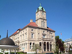
The approximately 100 acre Harrisonburg Downtown Historic District [61] embraces the historic commercial and institutional core of the city. The principal axis of the district is Main Street, which runs approximately north–south through the district. Another principal thoroughfare is Liberty Street, which parallels Main Street. The principal cross axis is Market Street (US Highway 33), which intersects with Main Street on the east side of Court Square. [62] The Romanesque Revival/Renaissance Revival 1896-97 Rockingham County Courthouse commands the square, and surrounding blocks arc densely developed with early twentieth century high-rise bank buildings and other commercial buildings from the 1870s through the 1950s. Most residential buildings dates to after the Civil War, when South Main Street developed as Harrisonburg's elite residential avenue. Notable houses from the period include Victorian/Queen Anne masterpieces such as Ute 1890 Joshua Wilton House and rarities such as the late 1880s Octagon House. Several fine Gothic Revival churches date to the early years of the twentieth century. Industrial buildings and warehouses date largely to the first half of the twentieth century and include the 1908 City Produce Exchange, a poultry shipping plant, and the late 1920s Maphis Chapman Co. gas storage tank factory. A complex of mid-twentieth century cinder block warehouses clusters near the 1913 Chesapeake Western Railway Station and the 1920-21 Rockingham Milling Co. roller mill on Chesapeake Avenue. Alter World War I automobile dealerships appeared in the downtown area. An outstanding example is the 1920 Rockingham Motor Co., an inspired Tudor Revival/Art Deco design. Architectural modernism achieved popularity in the 1940s and early 1950s at the end of the period of significance. Harrisonburg's downtown experienced a number of losses during the late twentieth century, but the recent rehabilitation of several key buildings demonstrates a growing commitment to the preservation of the district's historic character. [62]

Other sites

In addition to the Thomas Harrison House, Hardesty-Higgins House, Harrisonburg Downtown Historic District, and Old Town Historic District, the Anthony Hockman House, Rockingham County Courthouse, Lucy F. Simms School, Whitesel Brothers, and Joshua Wilton House are listed on the National Register of Historic Places. [63]

Geography

According to the United States Census Bureau, the city has a total area of 17.4 square miles (45.1 km2), of which 17.3 square miles (44.8 km2) is land and 0.1 square miles (0.3 km2) (0.3%) is water. [64] The City of Harrisonburg comprises six watersheds, with Blacks Run being the primary watershed with 8.67 miles of stream and a drainage area of over 9000 acres. The city also drains into the Chesapeake Bay Watershed. Harrisonburg is in the western part of the Shenandoah Valley, a portion of the Valley and Ridge physiographic province. [65] Generally, the area is a rolling upland with local relief between 100 and 300 feet. [65]

Demographics

Historical population
CensusPop.Note
1860 1,023
1870 2,03699.0%
1880 2,83139.0%
1890 2,792−1.4%
1900 3,52126.1%
1910 4,87938.6%
1920 5,87520.4%
1930 7,23223.1%
1940 8,76821.2%
1950 10,81023.3%
1960 11,91610.2%
1970 14,60522.6%
1980 19,67134.7%
1990 30,70756.1%
2000 40,46831.8%
2010 48,91420.9%
2020 51,8145.9%
U.S. Decennial Census [66]
1790-1960 [67] 1900-1990 [68]
1990-2000 [69] 2010 [70] 2020 [71]

2020 census

Harrisonburg city, Virginia - Demographic Profile
(NH = Non-Hispanic)
Race / EthnicityPop 2010 [70] Pop 2020 [71] % 2010% 2020
White alone (NH)35,39131,45472.35%60.71%
Black or African American alone (NH)2,9113,9065.95%7.54%
Native American or Alaska Native alone (NH)67710.14%0.14%
Asian alone (NH)1,7052,0893.49%4.03%
Pacific Islander alone (NH)54200.11%0.04%
Some Other Race alone (NH)1121960.23%0.38%
Mixed Race/Multi-Racial (NH)1,0092,0332.06%3.92%
Hispanic or Latino (any race)7,66512,04515.67%23.25%
Total48,91451,814100.00%100.00%

Note: the US Census treats Hispanic/Latino as an ethnic category. This table excludes Latinos from the racial categories and assigns them to a separate category. Hispanics/Latinos can be of any race.

2010 census

This graph, using information from the 2000 federal census, illustrates the uneven distribution of age due to the two universities in Harrisonburg USA Harrisonburg city, Virginia age pyramid.svg
This graph, using information from the 2000 federal census, illustrates the uneven distribution of age due to the two universities in Harrisonburg

As of the census [72] of 2010, 48,914 people, 15,988 households, and 7,515 families resided in the city. The population density was 2,811.1/mi2 (1087.0/km2). The 15,988 housing units averaged 918.9/mi2 (355.3/km2). The racial makeup of the city was 78.4% White, 6.4% Black or African American, 0.3% Native American, 3.5% Asian, 0.1% Pacific Islander, 8.2% from other races, and 3.1% from two or more races. Hispanics or Latinos of any race were 15.7% of the population, up from 8.85% according to the census of 2000.

Of the 15,988 households, 22.1% had children under the age of 18 living with them, 32.7% were married couples living together, 10.1% had a female householder with no husband present, and 53.0% were not families. About 27.3% of all households were made up of individuals, and 17.4% had someone living alone who was 65 years of age or older. The average household size was 2.59, and the average family size was 3.06.

In the city, the population was distributed as 15.0% under the age of 18, 48.9% from 18 to 24, 21.2% from 25 to 44, 13.2% from 45 to 64, and 9.3% who were 65 years of age or older. The median age was 22.8 years. For every 100 females, there were 87.3 males.

The median income for a household in the city was $37,850, and for a family was $53,642. The per capita income for the city was $16,992. About 11.5% of families and 31.8% of the population were below the poverty line, including 19.6% of those under age 18 and 9.5% of those age 65 or over.

Politics

United States presidential election results for Harrisonburg, Virginia [73]
Year Republican Democratic Third party
No.%No.%No.%
2020 5,59132.72%11,02264.51%4732.77%
2016 6,26234.81%10,21256.77%1,5138.41%
2012 6,56542.10%8,65455.50%3742.40%
2008 6,04841.21%8,44457.54%1831.25%
2004 6,16555.89%4,72642.85%1391.26%
2000 5,74157.65%3,48234.97%7357.38%
1996 4,94555.33%3,34637.44%6467.23%
1992 4,93551.24%3,41435.44%1,28313.32%
1988 5,37664.86%2,79933.77%1131.36%
1984 5,22168.15%2,38431.12%560.73%
1980 3,38858.45%1,89632.71%5128.83%
1976 3,37663.01%1,80333.65%1793.34%
1972 3,62677.26%99221.14%751.60%
1968 2,85965.69%1,03623.81%45710.50%
1964 1,82050.70%1,76549.16%50.14%
1960 2,17272.04%83627.73%70.23%
1956 2,26578.29%57119.74%571.97%
1952 2,23877.82%63522.08%30.10%
1948 1,37758.55%75131.93%2249.52%
1944 1,30250.04%1,29249.65%80.31%
1940 1,00040.31%1,46258.93%190.77%
1936 89438.92%1,39060.51%130.57%
1932 66539.30%99558.81%321.89%
1928 1,03762.73%61637.27%00.00%
1924 63149.69%62449.13%151.18%
1920 70453.86%59445.45%90.69%
1916 31947.61%34651.64%50.75%

Like most of the Shenandoah Valley, Harrisonburg was among the first areas of Virginia where old-line Southern Democrats began splitting their tickets. The city went Republican at every presidential election from 1944 to 2004. In 2008, however, Barack Obama carried the city by a margin of 16 percent—slightly larger than the 14-point margin by which George W. Bush carried it four years earlier. The city has voted Democratic in every presidential election since then, and has become one of the few Democratic mainstays in this more conservative part of Virginia. In most elections, it is one of the few areas west of Charlottesville carried by Democrats.

Government

Head of the City Government in the 20th Century
City ManagerMayorVice-Mayor
TermNameTermNamePartyTermNameParty
Sep 1946–

Aug 1948 [74]

Bernard Denton
Sep 1948–

Aug 1950 [74]

Lawrence Loewner
Sep 1950–

Aug 1952 [74]

Sep 1952–

Aug 1954 [74]

Sep 1954–

Aug 1956 [74]

Walter GreenSep 1954–

Aug 1956 [75]

Dan L. LoganR
Sep 1956–

Aug 1958 [74]

Frank C. SwitzerSep 1956–

Aug 1958 [75]

Sep 1958–

Aug 1960 [74]

Sep 1958–

Aug 1960 [75]

Sep 1960–

Aug 1962 [74]

Sep 1960–

Aug 1962 [75]

Sep 1962–

Aug 1964 [74]

Sep 1962–

Aug 1964 [76]

Sep 1964–

Aug 1966 [74]

Sep 1966–

Aug 1968 [74]

Jun 1966 [77] Joseph MintzerD
Sep 1968–

Aug 1970 [74]

Roy Hjalmar

Erickson

RSep 1968–

Aug 1970 [78] [74]

Royal Kincheloe
1969–1974Marvin B. Milam
Sep 1970–

Aug 1972 [74]

Sep 1970–

Aug 1972 [74]

Edgar Warren Denton Jr.
Sep 1974–

Aug 1976 [79]

Sep 1974–

Aug 1976 [79]

Sep 1974–

Aug 1976 [79]

Sep 1976–

Aug 1978 [80]

Sep 1976–

Aug 1978 [80]

Sep 1976–

Aug 1978 [80]

Sep 1978–

Aug 1980 [81]

Sep 1978–

Aug 1980 [81]

Sep 1978–

Aug 1980 [81]

Walter Franklin Green III.
Sep 1980–

Aug 1982 [82]

Sep 1980–

Aug 1982 [82] [83]

Sep 1980–

Aug 1982 [82] [83]

Sep 1982–

Jun 1984

Sep 1982–

Jun 1983

Sep 1982–

Jun 1983

Jul 1983–

Jun 1984 [84]

Walter Franklin Green III.Jul 1983–

Jun 1984 [84]

Raymond C. Dingledine Jr.
Jul 1984–

Jun 1986 [85]

Jul 1984–

Jun 1986 [85]

Jul 1984–

Jun 1986 [85]

Jul 1986–

Jun 1988 [86]

Jul 1986–

Jun 1988 [86]

Jul 1986–

Jun 1988 [86]

Jul 1988–

Jun 1990 [87]

Jul 1988–

Jun 1990 [87]

Jul 1988–

Jun 1990 [87]

Jul 1990 [88]

Sep 1991

Jul 1990–

Jun 1992 [88]

Jul 1990–

Jun 1992 [88]

Elon W. Rhodes
Oct 1991–

Oct 1992 [88]

Roger D. Baker (acting)
Jul 1992–

Jun 1994 [89]

C. Robert HeathJul 1992–

Jun 1994 [89]

John N. Neff
Nov 1992–

Jun 1994 [89]

Steven E. Stewart
Jul 1994 [90]

1997

Jul 1994–

Jun 1996 [90]

John N. NeffJul 1994–

Jun 1996 [90]

Emily R. Dingledine
Jul 1996–

Jun 1998 [91]

Rodney L. EagleIJul 1996–

Jun 1998 [91]

Hugh. J. LantzR
1997–Sep 2000
Jul 1998–

Jun 2000 [92]

Jul 1998–

Jun 2000 [92]

City ManagerMayorVice-Mayor
TermNameTermNamePartyTermNameParty
1997–Sep 2000Steven E. StewartJul 1998–

Jun 2000 [92]

Rodney L. EagleIJul 1998–

Jun 2000 [92]

Hugh. J. LantzR
Jul 2000–

Jun 2002 [93]

Carolyn W. FrankIJul 2000–

Jun 2002 [93]

Dorn W. Peterson
Sep 2000–

Jun 2004 [94]

Roger Baker
Jul 2002–

Jun 2004 [95]

Joseph Gus FitzgeraldDJul 2002–

Jun 2004 [95]

Larry M. RogersD
Jul 2004–

Jun 2007 [96] [97]

Jul 2004–

Jun 2006 [96]

Larry M. RogersDJul 2004–

Jun 2006 [96]

Rodney L. EagleI
Jul 2006–

Dec 2008 [98]

Rodney L. EagleIJul 2006–

Dec 2008 [98]

George W. Pace
Jul 2007–

Dec 2010 [99]

Kurt D. Hodgen
Jan 2009–

Dec 2010 [100]

Kai DegnerDJan 2009–

Dec 2010 [100]

Richard A. BaughD
Jan 2011–Oct 31, 2017 [101] Jan 2011–

2012 [101]

Richard A. BaughDJan 2011–

2012 [101]

Ted ByrdR
Jan 2013–

Dec 2014 [102]

Ted ByrdRJan 2013–

Dec 2014 [102]

Charles R. ChenaultI
Jan 2015–

Dec 2016 [103]

Christopher B. JonesDJan 2015–

Dec 2016 [74]

Richard BaughD
Jan 3, 2017–

Jan 1, 2019 [104]

Deanna R. ReedDJan 3, 2017–

Jan 1, 2019 [105]

Nov 1, 2017–Jan 15 2018 [106] Ande Banks (acting)
Jan 16, 2018–Dec 31 2021 [107] Eric Campbell
Jan 2, 2019–

Jan 3, 2021 [108]

Jan 2, 2019–

Jan 3, 2021 [108]

Sal RomeroD
Jan 4, 2021–

Jan 2, 2023 [109]

Jan 4, 2021–

Jan 2, 2023 [109]

Jan 01, 2022–Jan 02, 2023 [1] Ande Banks (acting)
Jan 03, 2023–incumbent [110] Ande BanksJan 3, 2023–incumbent [110] Jan 3, 2023–incumbent [110] Laura DentD

Education

School systems

Serving about 4,400 students (K–12), Harrisonburg City Public Schools comprises six elementary schools, two middle schools, and a high school. Eastern Mennonite School, a private school, serves grades K–12 with an enrollment of about 386 students. [111]

Higher education

James Madison University is the largest higher education institution in Harrisonburg. JMU Quad Fall 2015.JPG
James Madison University is the largest higher education institution in Harrisonburg.

High schools

Middle schools

Elementary schools

Other schools

Technical schools

Private schools

Points of interest

Events

Sports

Climate

The climate in this area is characterized by hot, humid summers and generally cool to cold winters. Harrisonburg has a humid subtropical climate, Cfa on climate maps according to the Köppen climate classification, but has four clearly defined seasons that vary significantly, if not having brief changes from summer to winter. [114] The USDA hardiness zone is 6b, which means average minimum winter temperature of −5 to 0 °F (−21 to −18 °C).

Notable people

Born

Raised

Resident

See also

References and notes

  1. 1 2 Harrisonburg, VA (January 14, 2022). "City Manager search moves forward with selection of firm" (PDF). City of Harrisonburg Press Release. Retrieved April 3, 2022.
  2. "Mayor Deanna R. Reed". City of Harrisonburg, VA. December 27, 2016.
  3. "City Council | City of Harrisonburg, VA". Harrisonburgva.gov. August 24, 2017. Retrieved September 30, 2017.
  4. "Council Member Monica Robinson". City of Harrisonburg, VA. January 5, 2023. Retrieved May 4, 2023.
  5. "Council Member Dany Fleming". City of Harrisonburg, VA. January 5, 2023. Retrieved May 4, 2023.
  6. "2019 U.S. Gazetteer Files". United States Census Bureau. Retrieved August 7, 2020.
  7. "U.S. Census website". United States Census Bureau . Retrieved January 31, 2008.
  8. "Harrisonburg – Populated Place". Geographic Names Information System . USGS . Retrieved May 8, 2008.
  9. "Find a County". National Association of Counties. Retrieved June 7, 2011.
  10. "Harrisonburg city, Harrisonburg city, Virginia". United States Census Bureau . Retrieved January 30, 2022.
  11. "Table 1. Annual Estimates of the Population of Metropolitan and Micropolitan Statistical Areas: April 1, 2010 to July 1, 2011". 2011 Population Estimates. United States Census Bureau, Population Division. April 20, 2009. Archived from the original (CSV) on April 27, 2012. Retrieved June 4, 2012.
  12. "JMU Facts & Figures". James Madison University. Retrieved September 15, 2015.
  13. "JMU Historical Timeline". JMU Centennial Office. Retrieved December 5, 2006.
  14. Schum, Guy (February 14, 2012). "The Plain People". Virginialiving.com. Retrieved September 30, 2017.
  15. 1 2 "Where Did Those 'We're Glad You're Our Neighbor' Signs Come From?". WAMU.org. Retrieved September 30, 2017.
  16. USA (April 1, 2000). "Pew Research Center Hispanic Trends". Pewhispanic.org. Archived from the original on September 30, 2017. Retrieved September 30, 2017.
  17. "ESL Students in HCPS". Harrisonburg.k12.va.us. Archived from the original on June 1, 2017. Retrieved September 30, 2017.
  18. "Harrisonburg City Schools - English as a Second Language". Harrisonburg.k12.va.us. Archived from the original on June 1, 2017. Retrieved September 30, 2017.
  19. "Rosetta Stone History". Rosettastone.com. Retrieved September 30, 2017.
  20. Kane, Joseph Nathan; Aiken, Charles Curry (2004). The American Counties. Scarecrow Press. p. 130. ISBN   0-8108-5036-2.
  21. Harrison, J. Houston (1935). Settlers by the Long Grey Trail J.K. Ruebush. p 214-249
  22. Julian Smith, 2007, Moon Virginia p. 246
  23. "A Brief History of Harrisonburg". Harrisonburgva.gov. Retrieved September 30, 2017.
  24. "Government Structure of Harrisonburg". Harrisonburgva.gov. April 8, 2016. Retrieved September 30, 2017.
  25. "Historic Growth Map" (PDF). Archived (PDF) from the original on October 9, 2022.
  26. Stephens City, Virginia was also called Newtown at this time.
  27. 1 2 Hagi, Randi B. (February 11, 2020). "The Legacy of Harrisonburg's 'Urban Renewal'". www.wmra.org. Retrieved April 29, 2020.
  28. "Welcome [landing page]". Celebrating Simms: The story of the Lucy F. Simms School. James Madison University & the Shenandoah Valley Black Heritage Center in association with Billo Harper. Retrieved January 29, 2019.
  29. 1 2 3 Hagi, Randi B. (February 12, 2020). "The Role of Race and Money in Harrisonburg's 'Urban Renewal'". www.wmra.org. Retrieved April 29, 2020.
  30. 1 2 "Remembering Project R4". Eightyone.info. Archived from the original on January 16, 2009. Retrieved September 30, 2017.
  31. "projects r-4 and r-16". Shenandoah Living Archive Prototype. Archived from the original on June 14, 2020. Retrieved April 29, 2020.
  32. "Harrisonburg's Urban Renewal Projects, R4 & R16". Learn Share Illuminate. Retrieved April 29, 2020.
  33. "A Guide to the Harrisonburg Redevelopment & Housing Authority Photographs, 1960-1987: SC 0235," Harrisonburg Redevelopment and Housing Authority Photographs, 1960-1987, SC 0235, Special Collections, Carrier Library, James Madison University, Harrisonburg, VA. https://ead.lib.virginia.edu/vivaxtf/view?docId=jmu/vihart00185.xml
  34. 1 2 3 "Mapping African American Life in Harrisonburg". public.imaginingamerica.org. Retrieved April 29, 2020.
  35. "First Baptist History". firstbaptisthbgva.org. Retrieved April 29, 2020.
  36. "Newtown Cemetery National Register of Historic Places Registration Form" (PDF). December 20, 2014. Archived (PDF) from the original on October 9, 2022.
  37. "Home". Harrisonburg Downtown Renaissance.
  38. Bolsinger, Andrew Scot (October 28, 2002). "Downtown". Daily News-Record . Harrisonburg, VA. Retrieved July 3, 2009.
  39. "Harrisonburg Downtown Historic District". Virginia Main Street Community: A National Register of Historic Places Travel Itinerary. National Park Service. Retrieved July 3, 2009.
  40. Creswell, Kelly (August 14, 2007). "Harrisonburg Streetscape". WHSV TV 3. Gray Television, Inc. Archived from the original on July 16, 2011. Retrieved July 3, 2009.
  41. "The Virginia Breeze: Bus from Blacksburg to Washington, DC". The Virginia Breeze: Bus from Blacksburg to Washington, DC | DRPT. Retrieved January 20, 2020.
  42. "Awards and Recognitions". City of Harrisonburg, VA. July 10, 2013. Retrieved October 27, 2016.
  43. "America's Favorite Towns". Travel + Leisure. Retrieved October 27, 2016.
  44. "The Best Cities to Raise an Outdoor Kid: The Winning 25 - Page 3 of 6 - Backpacker". Backpacker. July 1, 2009. Retrieved October 27, 2016.
  45. "The Top 61 Happiest Mountain Towns in the Blue Ridge". BlueRidgeCountry.com. Retrieved October 27, 2016.
  46. Hellman, Reed (August 14, 2017). "'Farm to table' means just that in Virginia's first Culinary District". Recreation News. Retrieved January 29, 2019.
  47. "Annual Events". Downtown Harrisonburg. Harrisonburg Downtown Renaissance. Retrieved January 29, 2019.
  48. "Taste of Downtown". Downtown Harrisonburg. Harrisonburg Downtown Renaissance. Archived from the original on January 29, 2019. Retrieved January 29, 2019.
  49. "Main Street vibe". Harrisonburg, VA: Friendly by Nature. Harrisonburg Tourism. Retrieved January 29, 2019.
  50. "SCCF OUT & ABOUT: LARKIN ARTS, HARRISONBURG". Staunton Creative Community Fund. September 17, 2012. Archived from the original on April 14, 2014. Retrieved April 13, 2014.
  51. Stacy, Sarah. "Larkin Arts hosts second annual juried art show". DNR Harrisonburg. Archived from the original on April 13, 2014.
  52. "2014 Open Engagement Program". Open Engagement.
  53. Jenner, Andrew. "Visiting With the Old Furnace Artist Residency". Old South High. Old South High. Archived from the original on July 29, 2014. Retrieved April 30, 2014.
  54. Jenkins, Jermiah. "Lurid Pictures + Super Gr8 Film Fest = Awesome Harrisonburg". Old South High. Archived from the original on June 29, 2014. Retrieved July 29, 2014.
  55. "About Us". Arts Council of the Valley. Archived from the original on April 16, 2014. Retrieved April 13, 2014.
  56. "Home - OASIS Fine Art & Craft". Oasisfineartandcraft.org. Retrieved September 30, 2017.
  57. 1 2 "Virginia Quilt Museum". VQM.
  58. "115-0008 The Harrison House (formerly the Thomas Harrison House)". www.dhr.virginia.gov.
  59. "Thomas Harrison House". City of Harrisonburg, VA. May 1, 2017.
  60. 1 2 "Hardesty-Higgins House Visitor Center". Visit Harrisonburg Virginia in the Shenandoah Valley. January 7, 2019.
  61. "Story Map Tour". harrisonburg.maps.arcgis.com.
  62. 1 2 "115-0187 Harrisonburg Downtown Historic District". www.dhr.virginia.gov.
  63. "National Register Information System". National Register of Historic Places . National Park Service. July 9, 2010.
  64. "US Gazetteer files: 2010, 2000, and 1990". United States Census Bureau. February 12, 2011. Retrieved April 23, 2011.
  65. 1 2 Ii, Thomas M. Gathright; Frischmann, Peter S. (1986). Geology of the Harrisonburg and Bridgewater quadrangles, Virginia. Vol. 60. Charlottesville, VA: Commonwealth of Virginia, Dept. of Mines, Minerals, and Energy, Division of Mineral Resources.
  66. "Census of Population and Housing from 1790-2000". US Census Bureau . Retrieved January 24, 2022.
  67. "Historical Census Browser". University of Virginia Library. Retrieved January 6, 2014.
  68. "Population of Counties by Decennial Census: 1900 to 1990". United States Census Bureau. Retrieved January 6, 2014.
  69. "Census 2000 PHC-T-4. Ranking Tables for Counties: 1990 and 2000" (PDF). United States Census Bureau. Archived (PDF) from the original on October 9, 2022. Retrieved January 6, 2014.
  70. 1 2 "P2 HISPANIC OR LATINO, AND NOT HISPANIC OR LATINO BY RACE - 2010: DEC Redistricting Data (PL 94-171) - Harrisonburg city, Virginia". United States Census Bureau .
  71. 1 2 "P2 HISPANIC OR LATINO, AND NOT HISPANIC OR LATINO BY RACE - 2020: DEC Redistricting Data (PL 94-171) - Harrisonburg city, Virginia". United States Census Bureau .
  72. "U.S. Census website". United States Census Bureau . Retrieved April 30, 2016.
  73. David Leip. "Dave Leip's Atlas of U.S. Presidential Elections". Uselectionatlas.org. Retrieved December 8, 2020.
  74. 1 2 3 4 5 6 7 8 9 10 11 12 13 14 15 16 "Previous Council Members" (PDF). The City of Harrisonburg Virginia. Archived (PDF) from the original on October 9, 2022. Retrieved August 8, 2022.
  75. 1 2 3 4 "The News Leader from Staunton, Virginia on September 2, 1960 · 2". Newspapers.com. September 2, 1960. Retrieved August 1, 2021.
  76. "Harrisonburg Daily News Record Archives, Nov 13, 1964, p. 1". NewspaperArchive.com. November 13, 1964. Retrieved August 1, 2021.
  77. "Harrisonburg Daily News Record Archives, Jun 15, 1966, p. 1". NewspaperArchive.com. June 15, 1966. Retrieved August 1, 2021.
  78. Virginia, Harrisonburg (January 7, 2013), 1969 City Council , retrieved August 1, 2021
  79. 1 2 3 "09-03-1974" (PDF). The City of Harrisonburg Virginia. September 3, 1974. Archived (PDF) from the original on October 9, 2022. Retrieved August 8, 2022.
  80. 1 2 3 "1976 City Council Minutes Jan to Dec" (PDF). The City of Harrisonburg Virginia. January 13, 1976. Archived (PDF) from the original on October 9, 2022. Retrieved August 8, 2022.
  81. 1 2 3 "1978 City Council Minutes Jan to Dec" (PDF). The City of Harrisonburg Virginia. January 3, 1978. Archived (PDF) from the original on October 9, 2022. Retrieved August 8, 2022.
  82. 1 2 3 "1980 City Council Minutes Jan to Dec" (PDF). The City of Harrisonburg Virginia. January 8, 1980. Archived (PDF) from the original on October 9, 2022. Retrieved August 8, 2022.
  83. 1 2 "1982 City Council Minutes Jan to Dec" (PDF). The City of Harrisonburg Virginia. January 12, 1982. Archived (PDF) from the original on October 9, 2022. Retrieved August 8, 2022.
  84. 1 2 "1983 City Council Minutes Jan to Dec" (PDF). The City of Harrisonburg Virginia. January 1, 1983. Archived (PDF) from the original on October 9, 2022. Retrieved August 8, 2022.
  85. 1 2 3 "1984 City Council Minutes Jan to Dec" (PDF). The City of Harrisonburg Virginia. January 10, 1984. Archived (PDF) from the original on October 9, 2022. Retrieved August 8, 2022.
  86. 1 2 3 "1986 City Council Minutes January to December" (PDF). The City of Harrisonburg Virginia. January 14, 1986. Archived (PDF) from the original on October 9, 2022. Retrieved August 8, 2022.
  87. 1 2 3 "1988 City Council Minutes Jan to Dec" (PDF). The City of Harrisonburg Virginia. January 12, 1988. Archived (PDF) from the original on October 9, 2022. Retrieved August 8, 2022.
  88. 1 2 3 4 "1990 City Council Minutes Jan to Dec" (PDF). The City of Harrisonburg Virginia. January 9, 1990. Archived (PDF) from the original on October 9, 2022. Retrieved August 8, 2022.
  89. 1 2 3 "1992 City Council Minutes Jan to Dec" (PDF). The City of Harrisonburg Virginia. January 14, 1992. Archived (PDF) from the original on October 9, 2022. Retrieved August 8, 2022.
  90. 1 2 3 "1994 City Council Minutes Jan to Dec" (PDF). The City of Harrisonburg Virginia. January 11, 1994. Archived (PDF) from the original on October 9, 2022. Retrieved August 8, 2022.
  91. 1 2 "1996 City Council Minutes Jan to Dec" (PDF). The City of Harrisonburg Virginia. January 23, 1996. Archived (PDF) from the original on October 9, 2022. Retrieved August 8, 2022.
  92. 1 2 3 4 "REORGANIZATION MEETING" (PDF). The City of Harrisonburg Virginia. July 1, 1998. Archived (PDF) from the original on October 9, 2022. Retrieved August 8, 2022.
  93. 1 2 "REORGANIZATION MEETING" (PDF). The City of Harrisonburg Virginia. July 1, 2000. Archived (PDF) from the original on October 9, 2022. Retrieved August 8, 2022.
  94. "REGULAR MEETING" (PDF). The City of Harrisonburg Virginia. September 12, 2000. Archived (PDF) from the original on October 9, 2022. Retrieved August 8, 2022.
  95. 1 2 "MINUTES - REORGANIZATION MEETING OF CITY COUNCIL" (PDF). The City of Harrisonburg Virginia. July 1, 2002. Archived (PDF) from the original on October 9, 2022. Retrieved August 8, 2022.
  96. 1 2 3 "REORGANIZATION MEETING" (PDF). The City of Harrisonburg Virginia. July 1, 2004. Archived (PDF) from the original on October 9, 2022. Retrieved August 8, 2022.
  97. "REGULAR MEETING" (PDF). The City of Harrisonburg Virginia. June 26, 2007. Archived (PDF) from the original on October 9, 2022. Retrieved August 8, 2022.
  98. 1 2 "REGULAR MEETING" (PDF). The City of Harrisonburg Virginia. July 11, 2006. Archived (PDF) from the original on October 9, 2022. Retrieved August 8, 2022.
  99. "REGULAR MEETING" (PDF). The City of Harrisonburg Virginia. July 10, 2007. Archived (PDF) from the original on October 9, 2022. Retrieved August 8, 2022.
  100. 1 2 "REORGANIZATION MEETING" (PDF). The City of Harrisonburg Virginia. January 2, 2009. Archived (PDF) from the original on October 9, 2022. Retrieved August 8, 2022.
  101. 1 2 3 "REORGANIZATION MEETING" (PDF). The City of Harrisonburg Virginia. January 3, 2011. Archived (PDF) from the original on October 9, 2022. Retrieved August 8, 2022.
  102. 1 2 "Special Meeting" (PDF). The City of Harrisonburg Virginia. February 10, 2014. Archived (PDF) from the original on October 9, 2022. Retrieved August 8, 2022.
  103. Breeze, Mike Dolzer | The (January 11, 2016). "From Wilson Hall to City Hall: An inside look at JMU alumnus Mayor Chris Jones". The Breeze. Retrieved June 20, 2021.
  104. "About". Deanna Reed for Harrisonburg City Council. Archived from the original on June 24, 2021. Retrieved June 20, 2021.
  105. Kline, Jared (January 3, 2017). "Harrisonburg council chooses new mayor, approves protocol change". www.whsv.com. Retrieved June 20, 2021.
  106. "Banks Named Acting Harrisonburg City Manager". WSVA News Talk Radio. Retrieved April 3, 2022.
  107. "City Manager Eric Campbell". Harrisonburgva.gov. August 24, 2017. Retrieved September 30, 2017.
  108. 1 2 Breeze, Jamie McEachin | The (January 29, 2019). "Historic mayor, vice-mayor pair highlight city's diversity". The Breeze. Retrieved June 20, 2021.
  109. 1 2 Newsroom, WHSV (January 4, 2021). "Harrisonburg re-elects Mayor Deanna Reed, Vice Mayor Sal Romero". www.whsv.com. Retrieved June 20, 2021.
  110. 1 2 3 "Deanna Reed remains mayor and Laura Dent becomes vice mayor — making more history for a historic council". The Harrisonburg Citizen. January 3, 2023. Retrieved May 4, 2023.
  111. Eastern Mennonite School profile Archived July 28, 2013, at the Wayback Machine .
  112. "Alpine Loop Gran Fondo" . Retrieved February 6, 2014.
  113. "Harrisonburg International Festival". Archived from the original on July 29, 2016. Retrieved February 6, 2014.
  114. "Climate Summary for Harrisonburg, Virginia". Weatherbase.com. Retrieved September 30, 2017.
  115. "Tom Lough Olympic Results". sports-reference.com. Archived from the original on December 13, 2012. Retrieved August 18, 2012.
  116. Samatar, Sofia (2018). From The White Mosque Archived January 17, 2019, at the Wayback Machine CMW Journal, vol. 10, no. 4. Retrieved 2019-16-01.

Related Research Articles

<span class="mw-page-title-main">Roanoke, Virginia</span> Independent city in Virginia, United States

Roanoke is an independent city in the U.S. state of Virginia. It is located in Southwest Virginia along the Roanoke River, in the Blue Ridge range of the greater Appalachian Mountains. Roanoke is approximately 50 miles (80 km) north of the Virginia–North Carolina border and 250 miles (400 km) southwest of Washington, D.C., along Interstate 81. At the 2020 census, Roanoke's population was 100,011, making it the most-populous city in Virginia west of the state capital Richmond. It is the primary population center of the Roanoke metropolitan area, which had a population of 315,251 in 2020.

<span class="mw-page-title-main">Winchester, Virginia</span> Independent city in Virginia, United States

Winchester is the northwesternmost independent city in the Commonwealth of Virginia, United States. It is the county seat of Frederick County, although the two are separate jurisdictions. As of the 2020 census, the city's population was 28,120. It is the principal city of the Winchester metropolitan area extending into West Virginia, which is a part of the Washington–Baltimore combined statistical area. Winchester is home to Shenandoah University and the Museum of the Shenandoah Valley.

<span class="mw-page-title-main">Waynesboro, Virginia</span> Independent city in Virginia, United States

Waynesboro is an independent city in the Commonwealth of Virginia. It is a principal city of the Staunton-Waynesboro Metropolitan Statistical Area. Waynesboro is located in the Shenandoah Valley and is surrounded by Augusta County. As of the 2020 census, the population was 22,196.

<span class="mw-page-title-main">Shenandoah County, Virginia</span> County in Virginia, United States

Shenandoah County is a county located in the Commonwealth of Virginia. As of the 2020 United States Census, the population was 44,186. Its county seat is Woodstock. It is part of the Shenandoah Valley region of Virginia.

<span class="mw-page-title-main">Rockingham County, Virginia</span> County in Virginia, United States

Rockingham County is a county located in the U.S. state of Virginia. As of the 2020 census, the population was 83,757. Its county seat is the independent city of Harrisonburg.

<span class="mw-page-title-main">Highland County, Virginia</span> County in Virginia, United States

Highland County is a county located in the Commonwealth of Virginia. As of the 2020 census, the population was 2,232, making it the state's least populous county. Its county seat is Monterey. Known as "Virginia's Switzerland" or "Virginia's Little Switzerland", Highland County is the least populous jurisdiction in Virginia, including counties and independent cities. Highland lays claim to being one of the least populous counties and one of the highest average elevations east of the Mississippi River.

<span class="mw-page-title-main">Buena Vista, Virginia</span> Independent city in Virginia, United States

Buena Vista is an independent city located in the Blue Ridge Mountains region of Virginia in the United States. As of the 2020 census, the population was 6,641. The Bureau of Economic Analysis combines the independent cities of Buena Vista and Lexington, along with surrounding Rockbridge County, for statistical purposes.

<span class="mw-page-title-main">Stephens City, Virginia</span> Incorporated town in Virginia, United States

Stephens City is an incorporated town in the southern part of Frederick County, Virginia, United States, with a population of 2,016 at the time of the 2020 census, and an estimated population of 2,096 in 2022. Founded by Peter Stephens in the 1730s, the colonial town was chartered and named for Lewis Stephens in October 1758. It was originally settled by German Protestants from Heidelberg.

<span class="mw-page-title-main">Bridgewater, Virginia</span> Town in Virginia, United States

Bridgewater is an incorporated town in Rockingham County, Virginia, United States. The population was 6,596 at the 2020 census. It is included in the Harrisonburg, Virginia Metropolitan Statistical Area.

<span class="mw-page-title-main">Dayton, Virginia</span> Town in Virginia, United States

Dayton is a town in Rockingham County, Virginia, United States. The population is 1,530 as of the 2010 census. It is included in the Harrisonburg, Virginia Metropolitan Statistical Area.

<span class="mw-page-title-main">Elkton, Virginia</span> Town in Virginia, United States

Elkton is an incorporated town in Rockingham County, Virginia, United States. It is included in the Harrisonburg Metropolitan Statistical Area. The population was 2,762 at the 2010 census. Elkton was named for the Elk Run stream.

<span class="mw-page-title-main">Mount Jackson, Virginia</span> Town in Virginia, United States

Mount Jackson is a town in Shenandoah County, Virginia, United States. The population was 1,994 at the 2010 census.

<span class="mw-page-title-main">Strasburg, Virginia</span> Town in Virginia, United States

Strasburg is a town in Shenandoah County, Virginia, United States, which was founded in 1761 by Peter Stover. It is the largest town by population in the county and is known for its grassroots art culture, pottery, antiques, and American Civil War history. The population was 7,083 at the 2020 census.

<span class="mw-page-title-main">Woodstock, Virginia</span> Town in Virginia, United States

Woodstock is a town and the county seat of Shenandoah County, Virginia, United States. It has a population of 5,212 according to the 2017 census. Woodstock comprises 3.2 square miles of incorporated area of the town, and is located along the "Seven Bends" of the North Fork of the Shenandoah River. While some tourism references list Woodstock as the fourth oldest town in Virginia, the area was sparsely settled and perhaps platted in 1752 or shortly thereafter, but the town was actually established by charter in 1761. While there are a number of Virginia towns closer to the eastern seaboard that claim earlier founding dates, Woodstock was one of the first towns west of the Blue Ridge Mountains.

<span class="mw-page-title-main">Staunton, Virginia</span> Independent city in Virginia, United States

Staunton is an independent city in the U.S. Commonwealth of Virginia. As of the 2020 census, the population was 25,750. In Virginia, independent cities are separate jurisdictions from the counties that surround them, so the government offices of Augusta County are in Verona, which is contiguous to Staunton. Staunton is a principal city of the Staunton-Waynesboro Metropolitan Statistical Area, which had a 2010 population of 118,502. Staunton is known for being the birthplace of Woodrow Wilson, the 28th U.S. president, and as the home of Mary Baldwin University, historically a women's college. The city is also home to Stuart Hall, a private co-ed preparatory school, as well as the Virginia School for the Deaf and Blind. It was the first city in the United States with a fully defined city manager system.

Shenandoah Valley Regional Airport is in Weyers Cave, Virginia, United States, 12 miles (19 km) northeast of Staunton. It is used for general aviation and is served by one airline, subsidized by the Essential Air Service program.

<span class="mw-page-title-main">WSVF-CD</span> Fox/CBS affiliate in Harrisonburg, Virginia

WSVF-CD is a low-power, Class A television station in Harrisonburg, Virginia, United States, affiliated with Fox and CBS. It is owned by Gray Television alongside ABC affiliate WHSV-TV and low-powered dual NBC/CW+ affiliate WSVW-LD. The three stations share studios on North Main Street/US 11 in downtown Harrisonburg, and operate a newsroom in Fishersville, serving Staunton, Waynesboro, and Augusta County. WSVF-CD's transmitter is located atop Massanutten Mountain. There is no separate website for WSVF-CD; instead, it is integrated with that of sister station WHSV-TV.

<span class="mw-page-title-main">Adam Miller (pioneer)</span> First permanent white settler in the Shenandoah Valley

With residency beginning in 1727, Adam Miller (Mueller) is recognized as the first permanent white settler in the Shenandoah Valley of Virginia, US. Born in 1703 in Schriesheim, Germany, Miller immigrated to America as a young married man, settling in Lancaster County, PA in 1724.

Dale Enterprise is an unincorporated community in Rockingham County, Virginia, United States. The name dates to 1872, when it was time to name the village's post office. The place was previously known as Millersville, after the Miller family who ran an early store there. After the Civil War, Mr. J. W. Minnick started a new mercantile “enterprise” at the crossroads of Silver Lake Road and Route 33. Minnick’s store was located near a “dale,” so the chosen name became Dale Enterprise.

<span class="mw-page-title-main">Shenandoah Germans</span>

The Shenandoah Valley region of Virginia and parts of West Virginia is home to a long-established German-American community dating to the 17th century. The earliest German settlers to Shenandoah, sometimes known as the Shenandoah Deitsch or the Valley Dutch, were Pennsylvania Dutch migrants who traveled from southeastern Pennsylvania. These German settlers traveled southward along what became known as the Great Wagon Road. They were descendants of German, Swiss, and Alsatian Protestants who began settling in Pennsylvania during the late 1600s. Among them were German Palatines who had fled the Rhineland-Palatinate region of southwestern Germany due to religious and political persecution during repeated invasions by French troops.