Grundy, Virginia | |
|---|---|
 U.S. Route 460 in Grundy | |
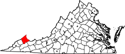
 Location of Grundy in Buchanan County, Virginia | |
| Coordinates: 37°16′40.40″N82°05′56.48″W / 37.2778889°N 82.0990222°W | |
| Country | United States |
| State | Virginia |
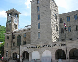
| County | Buchanan |
| Founded | 1858 |
| Incorporated | 1876 |
| Government | |
| • Mayor | Chris Mitchell |
| Area | |
• Total | 5.040 sq mi (13.053 km2) |
| • Land | 4.986 sq mi (12.913 km2) |
| • Water | 0.054 sq mi (0.139 km2) |
| Elevation | 1,060 ft (323 m) |
| Population | |
• Total | 875 |
| 837 | |
| • Density | 167.9/sq mi (64.82/km2) |
| Time zone | UTC−5 (Eastern (EST)) |
| • Summer (DST) | UTC−4 (EDT) |
| ZIP Code | 24614 |
| Area code | 276 |
| FIPS code | 51-33648 |
| GNIS feature ID | 1498485 [2] |
| Sales tax | 5.3% [5] |
| Website | townofgrundy.com |
Grundy is a town in Buchanan County, Virginia, United States, an area located within the Appalachian Mountains region. It is the county seat of Buchanan County. [6] The town is home to the Appalachian School of Law. The population was 875 at the 2020 census. [3]
Contents
- History
- Civil War events
- Red Jacket Mine explosion
- Grundy Flood-Control Project
- Base of a regional grocery store chain
- Education as a new sustaining industry
- Appalachian School of Law shooting
- Geography
- Transportation
- Demographics
- 2020 census
- 2010 census
- 2000 census
- Education
- Public schools
- Private institutions
- Post-secondary education
- Notable people
- Climate
- See also
- References
- External links
Legislation establishing Buchanan County in 1858 designated a plot of land at the confluence of the Levisa Fork River and Slate Creek as the seat of government for the county and directed the erection of the county courthouse on the plot, which marked the beginnings of what would be Grundy.
Although originally developed along the Levisa Fork River, which provided a transportation and power waterway, the town suffered from nine major floods since 1929 that have caused extensive damage, the last of which occurred in 1977. It is notable for having major businesses relocated in the 21st century to higher ground to prevent such damage in the future. A mountain opposite the historic town was blasted to provide a kind of plateau where much of the town was relocated and redeveloped. The federal project included construction of bridges and a flood wall, as well as the relocation of some roadways.
During the American Civil War, the town served as a stop-over for Union troops on their way to the Battle of Saltville.