Painter, Virginia

Last updated

Painter Virginia
Painter Garrisons United Methodist Church.jpg
Painter-Garrisons United Methodist Church, founded in 1784.
Accomack County Virginia incorporated and unincorporated areas Painter highlighted.svg
Location in Accomack County and the state of Virginia.
Coordinates: 37°35′8″N75°47′0″W / 37.58556°N 75.78333°W / 37.58556; -75.78333
CountryUnited States
State Virginia
County Accomack
Area
[1]
  Total0.65 sq mi (1.69 km2)
  Land0.65 sq mi (1.69 km2)
  Water0.00 sq mi (0.00 km2)
Elevation
[2]
36 ft (11 m)
Population
 (2010)
  Total229
  Estimate 
(2019) [3]
224
  Density344.09/sq mi (132.90/km2)
Time zone UTC−5 (Eastern (EST))
  Summer (DST) UTC−4 (EDT)
ZIP code
23420
Area code(s) 757, 948
FIPS code 51-60296 [4]
GNIS feature ID1472020 [2]

Painter is a town in Accomack County, Virginia, United States. The population was recorded at 229 at the 2010 census. [5]

Contents

History

Dusk in Painter, July 2018 Dusk in Painter, VA.jpg
Dusk in Painter, July 2018

From its earliest settlement, most villages and towns on the Eastern Shore of Virginia were located near the coasts at navigable ports where crops or livestock could be transported by boat. The coming of the New York, Pennsylvania, and Norfolk Railroad in the 1880s initiated a shift in population and commerce to the center of the shore and created the need for new towns, including the town of Painter.

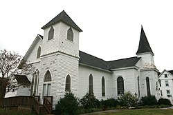
The Painter-Garrisons United Methodist Church was established in nearby Mappsburg, Virginia in 1784 when Bishop Francis Asbury made his first of six visits to the home of Jonathan Garrison. The congregation constructed a chapel by 1787, the first house of worship to be built by the Methodist Episcopal Church on the Eastern Shore. The present church was erected in 1855 and was the scene of the establishment of the Independent Convention of Accomack, a group of Methodist Churches that left the northern church in 1860 and, at the close of the war, joined the Methodist Episcopal Church, South. By the turn of the 20th century, as the population continued to shift from Mappsburg to Painter and other new towns, the church erected a second building in Painter in 1906. Twenty years later, the older church was moved to Painter and adjoined to the existing building at which time it took the name Painter-Garrisons Church. The 1855 building is today the second-oldest Methodist Church building on the Eastern Shore. [6]

Willowdale and Central High School are listed on the National Register of Historic Places. [7]

Geography

Painter is located at 37°35′8″N75°47′0″W / 37.58556°N 75.78333°W / 37.58556; -75.78333 (37.585632, 75.783445). [8]

According to the United States Census Bureau, the town has a total area of 0.6 square miles (1.6 km2), all of it land.

It lies at an elevation of 36 feet. [2]

Demographics

Historical population
CensusPop.Note
1960 349
1970 3634.0%
1980 321−11.6%
1990 259−19.3%
2000 246−5.0%
2010 229−6.9%
2019 (est.)224 [3] −2.2%
U.S. Decennial Census [9]

At the 2000 census there were 246 people, 104 households, and 69 families living in the town. The population density was 388.0 people per square mile (150.8/km2). There were 117 housing units at an average density of 184.6 per square mile (71.7/km2). The racial makeup of the town was 65.45% White, 30.08% African American, 0.41% Native American, 2.44% from other races, and 1.63% from two or more races. Hispanic or Latino of any race were 5.69%. [4]

Of the 104 households 22.1% had children under the age of 18 living with them, 47.1% were married couples living together, 19.2% had a female householder with no husband present, and 32.7% were non-families. 31.7% of households were one person and 21.2% were one person aged 65 or older. The average household size was 2.37 and the average family size was 2.99.

The age distribution was 22.8% under the age of 18, 9.3% from 18 to 24, 23.2% from 25 to 44, 19.5% from 45 to 64, and 25.2% 65 or older. The median age was 41 years. For every 100 females, there were 75.7 males. For every 100 females aged 18 and over, there were 69.6 males.

The median household income was $19,583 and the median family income was $31,250. Males had a median income of $24,167 versus $20,469 for females. The per capita income for the town was $14,350. About 13.9% of families and 18.5% of the population were below the poverty line, including 37.1% of those under the age of eighteen and 19.4% of those sixty-five or over.

Climate

The climate in this area is characterized by hot, humid summers and generally mild to cool winters. According to the Köppen Climate Classification system, Painter has a humid subtropical climate, abbreviated "Cfa" on climate maps. [10]

Climate data for Painter, Virginia (1991–2020 normals, extremes 1955–present)
MonthJanFebMarAprMayJunJulAugSepOctNovDecYear
Record high °F (°C)75
(24)
80
(27)
85
(29)
93
(34)
95
(35)
99
(37)
101
(38)
98
(37)
98
(37)
93
(34)
82
(28)
78
(26)
101
(38)
Mean maximum °F (°C)67.1
(19.5)
68.4
(20.2)
75.5
(24.2)
82.6
(28.1)
88.0
(31.1)
93.7
(34.3)
95.6
(35.3)
92.7
(33.7)
89.1
(31.7)
83.1
(28.4)
74.6
(23.7)
68.9
(20.5)
96.8
(36.0)
Mean daily maximum °F (°C)48.2
(9.0)
50.8
(10.4)
57.5
(14.2)
67.9
(19.9)
75.7
(24.3)
83.4
(28.6)
87.6
(30.9)
85.5
(29.7)
80.3
(26.8)
70.9
(21.6)
60.2
(15.7)
52.0
(11.1)
68.3
(20.2)
Daily mean °F (°C)39.3
(4.1)
41.1
(5.1)
47.4
(8.6)
57.2
(14.0)
65.7
(18.7)
74.0
(23.3)
78.5
(25.8)
76.4
(24.7)
71.2
(21.8)
61.1
(16.2)
50.8
(10.4)
43.1
(6.2)
58.8
(14.9)
Mean daily minimum °F (°C)30.4
(−0.9)
31.4
(−0.3)
37.3
(2.9)
46.5
(8.1)
55.7
(13.2)
64.6
(18.1)
69.4
(20.8)
67.4
(19.7)
62.1
(16.7)
51.3
(10.7)
41.4
(5.2)
34.2
(1.2)
49.3
(9.6)
Mean minimum °F (°C)14.4
(−9.8)
17.6
(−8.0)
23.1
(−4.9)
32.5
(0.3)
41.6
(5.3)
51.6
(10.9)
59.0
(15.0)
57.6
(14.2)
48.9
(9.4)
36.4
(2.4)
25.9
(−3.4)
20.4
(−6.4)
12.3
(−10.9)
Record low °F (°C)−5
(−21)
−1
(−18)
9
(−13)
24
(−4)
31
(−1)
36
(2)
47
(8)
44
(7)
39
(4)
24
(−4)
16
(−9)
−1
(−18)
−5
(−21)
Average precipitation inches (mm)3.55
(90)
3.07
(78)
3.96
(101)
3.28
(83)
3.65
(93)
4.44
(113)
4.99
(127)
4.48
(114)
4.53
(115)
4.28
(109)
3.05
(77)
3.94
(100)
47.22
(1,199)
Average snowfall inches (cm)3.4
(8.6)
1.5
(3.8)
0.5
(1.3)
0.0
(0.0)
0.0
(0.0)
0.0
(0.0)
0.0
(0.0)
0.0
(0.0)
0.0
(0.0)
0.0
(0.0)
0.0
(0.0)
1.2
(3.0)
6.6
(17)
Average precipitation days (≥ 0.01 in)10.69.511.210.110.49.710.310.08.28.98.811.2118.9
Average snowy days (≥ 0.1 in)1.20.90.40.00.00.00.00.00.00.00.00.73.2
Source: NOAA [11] [12]

Related Research Articles

<span class="mw-page-title-main">Northampton County, Virginia</span> County in Virginia, United States

Northampton County is a county located in the Commonwealth of Virginia. As of the 2020 census, the population was 12,282. Its county seat is Eastville. Northampton and Accomack Counties are a part of the larger Eastern Shore of Virginia.

<span class="mw-page-title-main">Accomack County, Virginia</span> County in Virginia, United States

Accomack County is a United States county located in the eastern edge of the Commonwealth of Virginia. Together, Accomack and Northampton counties make up the Eastern Shore of Virginia, which in turn is part of the Delmarva Peninsula, bordered by the Chesapeake Bay and the Atlantic Ocean. Accomac is the county seat.

<span class="mw-page-title-main">Hillsboro, Maryland</span> Town in Maryland

Hillsboro is a town in Caroline County, Maryland, United States. The population was 161 at the 2010 United States Census. Daffin House and St. Paul's Episcopal Church were listed on the National Register of Historic Places in 1975.

<span class="mw-page-title-main">Roulette Township, Pennsylvania</span> Township in Pennsylvania, United States

Roulette Township is a township in Potter County, Pennsylvania, United States. The population was 1,100 at the 2020 census. The small town of Roulette, a census-designated place with a population of about 800, is located near the center of the township.

<span class="mw-page-title-main">Accomac, Virginia</span> Town in Virginia, United States

Accomac is a town in and the county seat of Accomack County, Virginia, United States. The population was 526 at the 2020 census.

<span class="mw-page-title-main">Bloxom, Virginia</span> Town in Virginia, United States

Bloxom is a town in Accomack County, Virginia, United States. The population was 387 at the 2010 census.

<span class="mw-page-title-main">Chincoteague, Virginia</span> Town in Virginia, United States

Chincoteague is a town in Accomack County, Virginia, U.S. The town includes the whole of Chincoteague Island and an area of adjacent water. The population was 2,941 at the 2010 census. The town is a tourist gateway to the Chincoteague National Wildlife Refuge on adjacent Assateague Island, the location of a popular recreational beach and home of the Virginia herd of Chincoteague Ponies. These ponies and the annual Pony Swim are the subject of Marguerite Henry's 1947 children's book Misty of Chincoteague, which was made into the 1961 family film Misty, filmed on location.

<span class="mw-page-title-main">Hallwood, Virginia</span> Town in Virginia, United States

Hallwood is a town in Accomack County, Virginia, in the United States. As of the 2010 census, the town population was 206.

<span class="mw-page-title-main">Keller, Virginia</span> Town in Virginia, United States

Keller is a town in Accomack County, Virginia, United States. The population was 178 at the 2010 census.

<span class="mw-page-title-main">Melfa, Virginia</span> Town in Virginia, United States

Melfa is a town in Accomack County on the Eastern Shore of Virginia in the United States. The population was 408 at the 2010 census.

<span class="mw-page-title-main">Onancock, Virginia</span> Town in Virginia, United States

Onancock is a town in Accomack County, Virginia, United States. The population was 1,263 at the 2010 census.

<span class="mw-page-title-main">Onley, Virginia</span> Town in Virginia, United States

Onley is a town in Accomack County, Virginia, United States. The population was 516 at the 2010 census.

<span class="mw-page-title-main">Parksley, Virginia</span> Town in Virginia, United States

Parksley is a town in Accomack County, Virginia, United States. The population was 842 at the 2010 census. It is home to the Eastern Shore Railway Museum.

<span class="mw-page-title-main">Saxis, Virginia</span> Town in Virginia, United States

Saxis is a town in Accomack County, Virginia, United States. The population was 241 at the 2010 census.

<span class="mw-page-title-main">Wachapreague, Virginia</span> Town in Virginia, United States

Wachapreague is a town in Accomack County, Virginia, United States. The population was 257 at the 2020 census.

<span class="mw-page-title-main">Cheriton, Virginia</span> Town in Virginia, United States

Cheriton is a town in Northampton County, Virginia, United States. The population was 486 at the 2020 census.

<span class="mw-page-title-main">Eastville, Virginia</span> Town in Virginia, United States

Eastville is a town in Northampton County, Virginia, United States. The population was 300 at the 2020 census. It is the county seat of Northampton County. The Northampton County Courthouse Historic District is part of the Eastville Historic District at the county seat.

<span class="mw-page-title-main">Nassawadox, Virginia</span> Town in Virginia, United States

Nassawadox is a town in Northampton County, Virginia, United States. Per the 2020 census, the population was 533. The town, with an area of 0.4 square miles (1.0 km2), is located on U.S. Route 13 on Virginia's Eastern Shore, approximately five miles south of Exmore and 25 miles (40 km) north of the Chesapeake Bay Bridge-Tunnel.

<span class="mw-page-title-main">Glenville, West Virginia</span> Town in West Virginia, United States

Glenville is a town in and the county seat of Gilmer County, West Virginia, United States, along the Little Kanawha River. The population was 1,128 at the 2020 census. It is the home of Glenville State University.

<span class="mw-page-title-main">Belle Haven, Accomack County, Virginia</span> Town in Virginia, United States

Belle Haven is a town in Accomack and Northampton counties in the U.S. state of Virginia. The population was 532 at the 2010 census.

References

  1. "2019 U.S. Gazetteer Files". United States Census Bureau. Retrieved August 7, 2020.
  2. 1 2 3 U.S. Geological Survey Geographic Names Information System: Painter, Virginia
  3. 1 2 "Population and Housing Unit Estimates". United States Census Bureau. May 24, 2020. Retrieved May 27, 2020.
  4. 1 2 "U.S. Census website". United States Census Bureau . Retrieved January 31, 2008.
  5. "Profile of General Population and Housing Characteristics: 2010 Demographic Profile Data (DP-1): Painter town, Virginia". United States Census Bureau . Retrieved April 5, 2012.
  6. Mariner, Kirk (1979). Revival's Children: A Religious History of Virginia's Eastern Shore. Peninsula Press.
  7. "National Register Information System". National Register of Historic Places . National Park Service. July 9, 2010.
  8. "US Gazetteer files: 2010, 2000, and 1990". United States Census Bureau. February 12, 2011. Retrieved April 23, 2011.
  9. "Census of Population and Housing". Census.gov. Retrieved June 4, 2015.
  10. Climate Summary for Painter, Virginia
  11. "NowData – NOAA Online Weather Data". National Oceanic and Atmospheric Administration. Retrieved July 5, 2021.
  12. "Station: Painter 2 W, VA". U.S. Climate Normals 2020: U.S. Monthly Climate Normals (1991-2020). National Oceanic and Atmospheric Administration. Retrieved July 5, 2021.