Related Research Articles

Cherokee County is a county located in the U.S. state of Iowa. As of the 2020 census, the population was 11,658. The county seat is Cherokee. The county was formed on January 15, 1851, from open territory. It was named after the Cherokee people.

Pleasant Valley Township is a township in Potter County, Pennsylvania, United States. The population was 76 at the 2020 census.

Winterstown is a borough in York County, Pennsylvania, United States. The population was 609 at the time of the 2020 census.

Bohners Lake is a census-designated place (CDP) in Racine County, Wisconsin, United States. Its first syllable is pronounced as in "bone". The population of the CDP was 2,374 at the 2020 census. It is politically part of the Town of Burlington, together with Browns Lake, Wisconsin. There has been discussion of incorporating Bohners Lake as a village to prevent annexation by the City of Burlington. It was named for Antony Bohner, a French immigrant who established a resort on the lake of the same name.

Olejua is a town and municipality located in the province and autonomous community of Navarre, northern Spain.
Crumstown is an unincorporated community in LaPorte and St. Joseph counties, in the U.S. state of Indiana.

Etna is an unincorporated community in eastern Elizabeth Township, Lawrence County, Ohio, United States. It lies at an elevation of 620 feet.
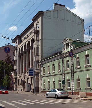
The Embassy of the Kyrgyz Republic in Moscow is the chief diplomatic mission of Kyrgyzstan in the Russian Federation. It is located at 64 Bolshaya Ordynka Street in the Yakimanka District of Moscow.
Cedar Township is a township in Adams County, North Dakota, United States. As of the 2010 census, its population was 24.
Wellington Wildlife Management Area is a Wildlife Management Area in Somerset County, Maryland.

The following timeline traces the territorial evolution of the U.S. State of Arizona.
Water Valley is a hamlet in the town of Hamburg in Erie County, New York, United States.

Devils Brook is a tributary of the Millstone River in central New Jersey in the United States.

General Lansana Conté Stadium is a new multi-use stadium in Conakry, Guinea. It was completed in 2011, it is used mostly for football and athletics competitions and it hosts some home matches for the Guinea national football team.
Bell Mountain is an unincorporated community in the Victor Valley region of the Mojave Desert, within San Bernardino County, southern California.
Indian Hills is an unincorporated community in Jackson Township, Steuben County, in the U.S. state of Indiana.
The Pennsylvania State Game Lands Number 26 are Pennsylvania State Game Lands in Bedford, Blair, Cambria, and Somerset Counties in Pennsylvania in the United States providing hunting, bird watching, equestrian, snowmobiling, and other activities.
Salisbury Island is an island in the Old River, in the Sacramento–San Joaquin River Delta. It is named after its original owner, tugboat operator Leslie Salsbury, who purchased it in 1945. It is in Contra Costa County, in northern California. Its coordinates are 37°51′00″N121°32′13″W.
References
- ↑ "Nandua". Geographic Names Information System . United States Geological Survey, United States Department of the Interior . Retrieved February 9, 2014.

37°37′27″N75°51′00″W / 37.62417°N 75.85000°W
| | This Accomack County, Virginia state location article is a stub. You can help Wikipedia by expanding it. |