Related Research Articles

South Browning is a census-designated place (CDP) in Glacier County, Montana, United States. The population was 1,785 at the 2010 census. South Browning is a rural village on the Blackfeet Indian Reservation. It is bordered to the north by the town of Browning.

Bombay is a town in Franklin County, New York, United States. The population was 1,357 at the 2010 census. The town was named after a major port city in India, now known as Mumbai, by an early landowner whose wife was from Byculla.

Hamburg is a borough in Berks County, Pennsylvania, United States. The population was 4,270 at the 2020 census. The town is thought to have been named after Hamburg, Germany, but this is likely to have been a corruption of Bad Homburg.
Union Township is a township in Crawford County, Pennsylvania, United States. The population was 861 at the 2020 census, down from 1,010 at the 2010 census.

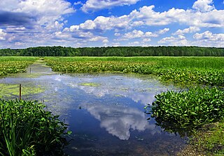
Belle Haven is a town in Accomack and Northampton counties in the U.S. state of Virginia. The population was 532 at the 2010 census.
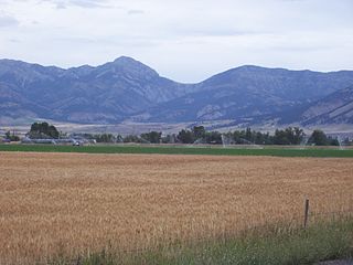
The Bridger Range, also known as the Bridger Mountains, is a subrange of the Rocky Mountains in southwestern Montana in the United States. The range runs mostly in a north–south direction between Bozeman and Maudlow. It is separated from the Gallatin Range to the south by Bozeman Pass; from the Horseshoe Hills to the west by Dry Creek; from the Crazy Mountains to the east by the Shields River valley; and from the Big Belt Mountains to the north by Sixteen Mile Creek. The highest point in the Bridger Range is Sacagawea Peak, which is visible to the northeast from Bozeman.
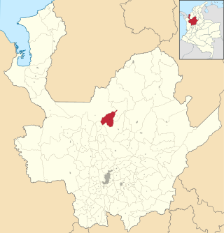
Briceño is a town and municipality in Antioquia Department, Colombia. Part of the subregion of Northern Antioquia.

Gulf of Saros or Saros Bay is a gulf in the Dardanelles, Turkey. Ancient Greeks called it the Gulf of Melas.

Originally called the High Bridge, the Hi-Line Bridge is a historic railroad bridge located over the Sheyenne River in Valley City, North Dakota. The bridge is 3,860 feet (1,180 m) long and 162 feet (49 m) above the river. Construction work began on July 5, 1906 and it was ready for service on May 8, 1908. At the time it was the longest bridge for its height in the world. It currently remains one of the longest and highest single track railroad viaducts in the United States, and was designated as a National Historic Civil Engineering Landmark by the American Society of Civil Engineers in 2005.

Menauhant is a neighborhood at the southern end of Central Avenue in East Falmouth, Massachusetts, United States. The community, which lies between Bournes Pond on the west and Eel Pond on the east, is located across Vineyard Sound from Martha's Vineyard. The community has approximately 105 homes, the earliest of which date to the 1870s, a small chapel that serves the community during the summer months, and the public Menauhant Beach. The neighborhood is the home of the Menauhant Yacht Club, which owns two private beaches, tennis courts and several boats, and hosts a summer program for members.
Lake Park is an unincorporated community in Hudson Township, LaPorte County, Indiana.

Hall is an unincorporated community in Gregg Township, Morgan County, in the U.S. state of Indiana.
Kincaid is an unincorporated community in Alleghany County, Virginia, United States.

Beech Grove is an unincorporated community in Nelson County, Virginia, United States.
Little Rockies National Forest was established by the U.S. Forest Service in Montana on March 2, 1907 with 31,000 acres (130 km2). On July 1, 1908 the entire forest was combined with Little Belt, Snowy Mountains and Highwood Mountains National Forests to establish Jefferson National Forest (Montana) and the name was discontinued. The entire Jefferson National Forest was later consolidated with the Lewis and Clark National Forest. The former Forest Service lands in the LIttle Rockies are now administered by the Bureau of Land Management.
Twifu Praso is a town and is the district capital of Twifu/Atii/Morkwaa District Assembly of the Central Region.

Trimbleville, Pennsylvania, also known as Trimble's Ford and the Trimbleville Historic District is a hamlet of roughly six homes that is located in southern Chester County, Pennsylvania, approximately two miles south of Marshallton.
Haney Corner is an unincorporated community in Shelby Township, Ripley County, in the U.S. state of Indiana.
Downey Corner is an unincorporated community in Cass Township, Ohio County, in the U.S. state of Indiana.
References
- ↑ "Lecato". Geographic Names Information System . United States Geological Survey, United States Department of the Interior . Retrieved February 9, 2014.

37°56′20″N75°33′00″W / 37.93889°N 75.55000°W
| | This Accomack County, Virginia state location article is a stub. You can help Wikipedia by expanding it. |