Northampton County is a county located in the Commonwealth of Virginia. As of the 2020 census, the population was 12,282. Its county seat is Eastville. Northampton and Accomack Counties are a part of the larger Eastern Shore of Virginia.

Accomack County is a United States county located in the eastern edge of the Commonwealth of Virginia. Together, Accomack and Northampton counties make up the Eastern Shore of Virginia, which in turn is part of the Delmarva Peninsula, bordered by the Chesapeake Bay and the Atlantic Ocean. Accomac is the county seat.

Jeffersonville is a home rule-class city in Montgomery County, Kentucky, in the United States. The population was 1,708 as of the 2020 census, up from 1,506 in 2010. It is part of the Mount Sterling micropolitan area.
Accomac is a town in and the county seat of Accomack County, Virginia, United States. The population was 526 at the 2020 census.

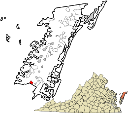
Bloxom is a town in Accomack County, Virginia, United States. The population was 387 at the 2010 census.

Chincoteague is a town in Accomack County, Virginia, U.S. The town includes the whole of Chincoteague Island and an area of adjacent water. The population was 3,344 at the 2020 census. The town is a tourist gateway to the Chincoteague National Wildlife Refuge on adjacent Assateague Island, the location of a popular recreational beach and home of the Virginia herd of Chincoteague Ponies. These ponies and the annual Pony Swim are the subject of Marguerite Henry's 1947 children's book Misty of Chincoteague, which was made into the 1961 family film Misty, filmed on location.

Hallwood is a town in Accomack County, Virginia, in the United States. As of the 2010 census, the town population was 206.
Keller is a town in Accomack County, Virginia, United States. The population was 178 at the 2010 census.
Melfa is a town in Accomack County on the Eastern Shore of Virginia in the United States. The population was 408 at the 2010 census.

Onley is a town in Accomack County, Virginia, United States. The population was 516 at the 2010 census.

Painter is a town in Accomack County, Virginia, United States. The population was recorded at 229 at the 2010 census.

Parksley is a town in Accomack County, Virginia, United States. The population was 842 at the 2010 census. It is home to the Eastern Shore Railway Museum.

Saxis is a town in Accomack County, Virginia, United States. The population was 241 at the 2010 census.

Wachapreague is a town in Accomack County, Virginia, United States. The population was 257 at the 2020 census.
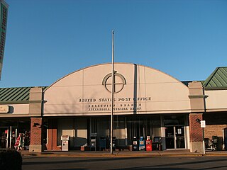
Belle Haven is a census-designated place (CDP) in Fairfax County, Virginia, United States. Nearby CDPs are Huntington (northwest), Groveton (southwest) and Fort Hunt (south). The population of Belle Haven was 6,851 at the 2020 census.
Groveton is a census-designated place (CDP) in Fairfax County, Virginia, United States. The population was 14,598 at the 2010 census, down from 21,296 in 2000 due to a reduction in area. Located south of the city of Alexandria, it encompasses numerous neighborhoods including Groveton, Bucknell Manor, Stoneybrooke, and portions of Hollin Hills. Huntley Meadows Park, Fairfax County's largest park, is located in the southwest part of the CDP.

Huntington is a census-designated place (CDP) in Fairfax County, Virginia, United States. The population was 11,267 at the 2010 census. It is located next to the southern border of the city of Alexandria and is part of the Washington metropolitan area. Its main component is the namesake Huntington subdivision, a late-1940s neighborhood of mainly duplex homes.

Cheriton is a town in Northampton County, Virginia, United States. The population was 486 at the 2020 census.

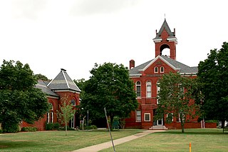
Eastville is a town in Northampton County, Virginia, United States. The population was 300 at the 2020 census. It is the county seat of Northampton County. The Northampton County Courthouse Historic District is part of the Eastville Historic District at the county seat.

New Haven is a town in Mason County, West Virginia, United States, along the Ohio River. The population was 1,485 at the 2020 census. It is part of the Point Pleasant, WV–OH Micropolitan Statistical Area.