Clifton Forge, Virginia

Last updated

Clifton Forge, Virginia
Downtown Clifton Forge, Virginia, January 2008.jpg
Downtown Clifton Forge
Seal of Clifton Forge, Virginia.png
Shenandoah Valley.svg
Red pog.svg
Clifton Forge
USA Virginia location map.svg
Red pog.svg
Clifton Forge
Usa edcp location map.svg
Red pog.svg
Clifton Forge
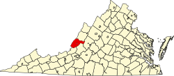
Coordinates: 37°49′11″N79°49′25″W / 37.81972°N 79.82361°W / 37.81972; -79.82361
Country United States
State Virginia
County Alleghany
Settlement1700s
Williamson's StationFebruary 13, 1861
Incorporated (town)October 19, 1884
Incorporated (independent city)March 31, 1906
Incorporated (town)January 21, 2001
Named after The Clifton estate in Lexington
Government
  MayorJeff Irvine
Area
[1]
  Total
3.08 sq mi (7.98 km2)
  Land3.02 sq mi (7.82 km2)
  Water0.06 sq mi (0.15 km2)
Elevation
1,083 ft (330 m)
Population
 (2020)
  Total
3,555
  Density1,200/sq mi (450/km2)
ZIP Code
24422
Area codes 540 and 826
FIPS code 51-17440 [2]
GNIS feature ID1492780 [3]
Website Official website
Masonic Amphitheater in Clifton Forge Clifton Forge - Masonic Amphitheatre.jpg
Masonic Amphitheater in Clifton Forge

Clifton Forge is a town in Alleghany County, Virginia, United States which is part of the greater Roanoke Region. [4] The population was 3,555 at the 2020 census. The Jackson River flows through the town, which as a result was once known as Jackson's River Station.

Contents

Clifton Forge was an independent city during the 2000 census. However, in 2001, Clifton Forge gave up its city status and reverted to a town. In previous decades, the railroad was a major employer. Clifton Forge is known for its mountain views and clear streams.

History

Clifton Forge Commercial Historic District, Clifton Forge Residential Historic District, Clifton Furnace, Jefferson School, and Longdale Furnace Historic District are listed on the National Register of Historic Places. [5] [6]

Geography

Clifton Forge is located at 37°49′11″N79°49′24″W / 37.81972°N 79.82333°W / 37.81972; -79.82333 (37.819801, -79.823584). [7]

According to the United States Census Bureau, the town had a total area of 3.1 square miles (8.0 km2), all land.

Portions of the town were built upon a bridge, elevating the town above a stream.

Climate

The climate in this area is characterized by hot, humid summers and generally mild to cool winters. According to the Köppen Climate Classification system, Clifton Forge has a humid subtropical climate, abbreviated "Cfa" on climate maps. [8]

Demographics

Historical population
CensusPop.Note
1890 1,792
1900 3,57999.7%
1910 5,74860.6%
1920 6,1647.2%
1930 6,83911.0%
1940 6,461−5.5%
1950 5,795−10.3%
1960 5,268−9.1%
1970 5,5014.4%
1980 5,046−8.3%
1990 4,679−7.3%
2000 4,289−8.3%
2010 3,884−9.4%
2020 3,555−8.5%
U.S. Decennial Census [9]

2020 census

As of the census of 2020, there were 3,555 people residing in the town. There were 1,988 housing units. The racial makeup of the town was 82.0% White, 11.7% African American or Black, 0.2% American Indian, 0.4% Asian, 0.1% Pacific Islander, 0.6% from other races, and 5.0% from two or more races. Hispanic or Latino of any race were 1.9% of the population.

2010 census

As of the census [2] of 2010, there were 3,884 people, 1,701 households, and 982 families residing in the town. The population density was 1,252.9 people per square mile (483.7 people/km2). There were 2,004 housing units at an average density of 646.5 units per square mile (249.6 units/km2). The racial makeup of the city was 84.4% White, 11.8% Black or African American, 0.2% Native American, 0.4% Asian, 0.4% from other races, and 2.8% from two or more races. Hispanic or Latino of any race were 1.7% of the population.

There were 1,701 households, out of which 23.9% had children under the age of 18 living with them, 37.8% were married couples living together, 13.8% had a female householder with no husband present, and 42.3% were non-families. 37.4% of all households were made up of individuals, and 19.1% had someone living alone who was 65 years of age or older. The average household size was 2.18 and the average family size was 2.85.

In the city, the population was spread out, with 21.7% under the age of 18, 6.8% from 18 to 24, 20.4% from 25 to 44, 28.5% from 45 to 64, and 22.6% who were 65 years of age or older. The median age was 45.8 years. For every 100 females, there were 87.2 males. For every 100 females age 18 and over, there were 82.7 males.

The median income for a household in the city was $34,256, and the median income for a family was $53,547. Males had a median income of $38,500 versus $29,630 for females. The per capita income for the city was $20,833. About 14.3% of families and 23.3% of the population were below the poverty line, including 33.4% of those under age 18 and 10.4% of those age 65 or over.

Government

Clifton Forge operates a Mayor–council form of government. Clifton Forge Town Council is composed of five council members who are elected at-large and serve overlapping four year terms. A Mayor and Vice Mayor are selected by the Council out of its membership.

Education

Clifton Forge is served by Alleghany Highlands Public Schools. [10] Public school students residing in Clifton Forge are zoned to attend Mountain View Elementary School, Clifton Middle School (until 2023), and Alleghany High School.

Mountain Gateway Community College is located west of the town.

Infrastructure

Public safety

Law enforcement is provided by the Clifton Forge Police Department. Fire protection is provided by the Clifton Forge Fire Department which operates a fire station within the town. Emergency medical services are provided by the Clifton Forge Fire Department and Clifton Forge Rescue Squad.

Transportation

Air

Ingalls Field, located near Hot Springs, is the closest general aviation airport to the town. The Greenbrier Valley Airport and Roanoke-Blacksburg Regional Airport are the closest airports with commercial service.

Roads

Clifton Forge is serviced by three major highways, Interstate 64, U.S. Route 60, and U.S. Route 220.

Amtrak's Cardinal P051 going through Lower Clifton Yard. Amtrak "The Cardinal" - Clifton Forge, VA.png
Amtrak's Cardinal P051 going through Lower Clifton Yard.

Rail

Amtrak, the national passenger rail service, provides service to the Clifton Forge station with the Cardinal route. Clifton Forge also serves a major locomotive fuel facility for CSX Transportation and is home to the Chesapeake & Ohio Historical Society and C&O Railway Heritage Center.

Notable people

Natives

People born in Clifton Forge:

Politics

United States presidential election results for Clifton Forge, Virginia [16]
Year Republican Democratic Third party(ies)
No.%No.%No.%
1908 13324.27%40273.36%132.37%
1912 6313.91%29364.68%9721.41%
1916 10416.99%45574.35%538.66%
1920 27426.52%72770.38%323.10%
1924 22523.22%44746.13%29730.65%
1928 78156.92%59143.08%00.00%
1932 32825.81%91772.15%262.05%
1936 34322.13%1,19977.35%80.52%
1940 35322.88%1,17976.41%110.71%
1944 41527.63%1,08272.04%50.33%
1948 45132.10%81858.22%1369.68%
1952 93653.46%81146.32%40.23%
1956 1,12561.48%63334.59%723.93%
1960 88553.22%77146.36%70.42%
1964 85040.44%1,25259.56%00.00%
1968 92543.59%73434.59%46321.82%
1972 1,12763.17%57532.23%824.60%
1976 77040.68%99352.46%1306.87%
1980 71639.23%1,01255.45%975.32%
1984 96551.44%89647.76%150.80%
1988 75943.65%96155.26%191.09%
1992 63233.74%95851.15%28315.11%
1996 48629.62%97459.35%18111.03%
2000 61340.01%86856.66%513.33%

See also

References

  1. "2019 U.S. Gazetteer Files". United States Census Bureau. Retrieved August 7, 2020.
  2. 1 2 "U.S. Census website". United States Census Bureau . Retrieved May 14, 2011.
  3. U.S. Geological Survey Geographic Names Information System: Clifton Forge, Virginia
  4. Roanoke Region of Virginia
  5. "National Register Information System". National Register of Historic Places . National Park Service. July 9, 2010.
  6. "National Register of Historic Places Listings" (PDF). Weekly List of Actions Taken on Properties: 8/13/12 through 8/17/12. National Park Service. August 24, 2012. Archived from the original on August 11, 2014. Retrieved May 26, 2013.
  7. "US Gazetteer files: 2010, 2000, and 1990". United States Census Bureau. February 12, 2011. Retrieved April 23, 2011.
  8. Climate Summary for Clifton Forge, Virginia
  9. "Census of Population and Housing". Census.gov. Retrieved June 4, 2015.
  10. Geography Division (January 8, 2021). 2020 CENSUS - SCHOOL DISTRICT REFERENCE MAP: Alleghany County, VA (PDF) (Map). U.S. Census Bureau . Retrieved July 1, 2025. - Text list
  11. "Richard L. Hoffman (1927–2012) – Obituary" (PDF). zobodat.at. 2012. Archived (PDF) from the original on October 7, 2022. Retrieved February 15, 2023.
  12. "Johnny Humphries Stats".
  13. "NC State Athletic Hall of Fame: Trudi Lacey".
  14. Gates, Henry Louis Jr.; Higginbotham, Evelyn Brooks (2004). African American Lives . New York: Oxford University Press. ISBN   9780195160246.
  15. "Ira De Augustine Reid papers". New York Public Library. Retrieved September 9, 2016.
  16. "Dave Leip's Atlas of U.S. Presidential Elections".

Further reading

37°49′11″N79°49′25″W / 37.819801°N 79.823584°W / 37.819801; -79.823584