Richlands, Virginia

Last updated
Richlands, Virginia
Richlands-Front-Suffolk-va.jpg
Intersection of Front and Suffolk in Richlands
RichlandsSeal.png
Motto: 
The Center of a Friendly Circle
VAMap-doton-Richlands.PNG
Location in the Commonwealth of Virginia
Coordinates: 37°5′40″N81°48′22″W / 37.09444°N 81.80611°W / 37.09444; -81.80611
Country United States
State Virginia
County Tazewell
Incorporated 1892
Government
   Mayor Rodney “Rod” Cury [1]
Area
[2]
  Total5.71 sq mi (14.77 km2)
  Land5.65 sq mi (14.63 km2)
  Water0.06 sq mi (0.14 km2)
Elevation
[3]
1,933 ft (589 m)
Population
 (2020)
  Total5,261
  Density926.37/sq mi (357.70/km2)
 U.S. Census Bureau, 2000 Population Estimates
Time zone UTC-5 (EST)
  Summer (DST) UTC-4 (EDT)
ZIP code
24641
Area code 276
FIPS code 51-66928 [4]
GNIS feature ID1473194 [3]
Website http://town.richlands.va.us/

Richlands is a town in Tazewell County, Virginia, United States. The population was 5,261 at the 2020 census. It is part of the Bluefield, WV-VA micropolitan area which has a population of 107,578.

Contents

History

Located along the banks of the Clinch River, Richlands began as a farming community and was named for its fertile "rich lands."

Miners at the Virginia-Pocahontas Coal Company Mine #4 near Richlands, 1974 Miners at the Virginia-Pocahontas Coal Company Mine.jpg
Miners at the Virginia-Pocahontas Coal Company Mine #4 near Richlands, 1974

The Clinch Valley Coal & Iron Company began to develop Richlands in 1890, and company officials hoped Richlands' readily available coal, iron, and timber might make it the "Pittsburgh of the South." The company abandoned its plans following the stock market crash of 1893. [5]

In February 1893, Richlands was the site of a mass lynching of five black railroad workers after it was alleged some of the men had robbed and beaten a white man. Four of the railroad workers were arrested and held in the Richlands jail, but the jailor was overpowered by a mob of white townspeople, including James Hurt, a magistrate and member of the Richlands town council, and James Crabtree, a prominent businessman, who removed the four men and hanged them from the same tree. A fifth black railroad worker was later found and lynched. [6]

The Richlands Historic District encompasses much of downtown Richlands, and the Tazewell Avenue Historic District, and Williams House, are both listed on the National Register of Historic Places. [7]

Geography

Richlands is situated along the Clinch River just east of the Tazewell-Russell county line. Cedar Bluff borders Richlands to the east, and the community of Raven lies just to the west. U.S. Route 460 and Virginia State Route 67 both traverse Richlands.

According to the United States Census Bureau, the town has a total area of 2.7 square miles (6.9 km2), all land.

Climate

The Trewartha climate classification for Richlands is temperate oceanic due to five months of winter chill (monthly means below 10 °C (50 °F)), abbreviated "Do" on climate maps.

Climate data for Richlands, Virginia (1991–2020 normals, extremes 1989–present)
MonthJanFebMarAprMayJunJulAugSepOctNovDecYear
Record high °F (°C)72
(22)
77
(25)
85
(29)
91
(33)
90
(32)
96
(36)
96
(36)
93
(34)
95
(35)
91
(33)
82
(28)
79
(26)
96
(36)
Mean daily maximum °F (°C)44.1
(6.7)
47.7
(8.7)
55.7
(13.2)
66.1
(18.9)
74.1
(23.4)
80.4
(26.9)
83.2
(28.4)
82.7
(28.2)
78.1
(25.6)
67.8
(19.9)
57.1
(13.9)
47.6
(8.7)
65.4
(18.6)
Daily mean °F (°C)33.4
(0.8)
36.5
(2.5)
43.2
(6.2)
52.5
(11.4)
61.3
(16.3)
68.9
(20.5)
72.3
(22.4)
71.4
(21.9)
65.7
(18.7)
54.3
(12.4)
44.0
(6.7)
36.8
(2.7)
53.4
(11.9)
Mean daily minimum °F (°C)22.7
(−5.2)
25.2
(−3.8)
30.8
(−0.7)
38.8
(3.8)
48.6
(9.2)
57.4
(14.1)
61.5
(16.4)
60.2
(15.7)
53.4
(11.9)
40.8
(4.9)
31.0
(−0.6)
26.1
(−3.3)
41.4
(5.2)
Record low °F (°C)−16
(−27)
−18
(−28)
−8
(−22)
19
(−7)
27
(−3)
37
(3)
46
(8)
42
(6)
32
(0)
20
(−7)
5
(−15)
−15
(−26)
−18
(−28)
Average precipitation inches (mm)3.35
(85)
3.28
(83)
4.02
(102)
3.98
(101)
4.47
(114)
4.30
(109)
4.75
(121)
3.82
(97)
3.36
(85)
2.72
(69)
2.77
(70)
3.78
(96)
44.60
(1,133)
Average snowfall inches (cm)6.3
(16)
4.4
(11)
2.9
(7.4)
0.3
(0.76)
0.0
(0.0)
0.0
(0.0)
0.0
(0.0)
0.0
(0.0)
0.0
(0.0)
0.0
(0.0)
0.3
(0.76)
3.4
(8.6)
17.6
(45)
Average precipitation days (≥ 0.01 in)13.412.413.412.713.812.813.210.49.29.010.313.0143.6
Average snowy days (≥ 0.1 in)3.42.51.80.20.00.00.00.00.00.00.42.010.3
Source: NOAA [8] [9]

Demographics

Historical population
CensusPop.Note
1900 475
1910 74356.4%
1920 1,17157.6%
1930 1,35515.7%
1940 2,20362.6%
1950 4,648111.0%
1960 4,9636.8%
1970 4,843−2.4%
1980 5,79619.7%
1990 4,456−23.1%
2000 4,144−7.0%
2010 5,82340.5%
2020 5,261−9.7%
U.S. Decennial Census [10]

At the 2000 census there were 4,144 people, 1,882 households, and 1,223 families living in the town. The population density was 1,565.7 people per square mile (603.8/km2). There were 2,137 housing units at an average density of 807.4 per square mile (311.4/km2). The racial makeup of the town was 98.75% White, 0.05% African American, 0.12% Native American, 0.51% Asian, 0.19% from other races, and 0.39% from two or more races. Hispanic or Latino of any race were 0.34%. [4]

Of the 1,882 households 25.2% had children under the age of 18 living with them, 48.7% were married couples living together, 12.8% had a female householder with no husband present, and 35.0% were non-families. 32.1% of households were one person and 15.6% were one person aged 65 or older. The average household size was 2.20 and the average family size was 2.76.

The age distribution was 20.1% under the age of 18, 8.3% from 18 to 24, 27.7% from 25 to 44, 25.4% from 45 to 64, and 18.5% 65 or older. The median age was 41 years. For every 100 females there were 81.9 males. For every 100 females age 18 and over, there were 79.0 males.

The median household income was $23,712 and the median family income was $30,257. Males had a median income of $30,682 versus $18,670 for females. The per capita income for the town was $15,548. About 13.6% of families and 17.8% of the population were below the poverty line, including 24.1% of those under age 18 and 16.9% of those age 65 or over.

Education

Richlands is served by the Tazewell County Public School System. Schools in Richlands include:

It is served by Southwest Virginia Community College, which is located in nearby Wardell, Virginia. King University, based in Bristol, Tennessee, has a satellite campus at SWVCC.

Blues musician Mississippi John Hurt performed Richland Women Blues. The lyrics were risqué for the early 1930s, filled with sexual double entendres. [11] [12]

Virginian singer and pianist Bruce Hornsby wrote a song set in Richlands, entitled "The Road Not Taken". It appears on his 1988 album Scenes from the Southside . [13]

Notable people

Related Research Articles

<span class="mw-page-title-main">Russell County, Virginia</span> County in Virginia, United States

Russell County is a county located in the Commonwealth of Virginia. As of the 2020 census, the population was 25,781. Its county seat is Lebanon.

<span class="mw-page-title-main">Eutaw, Alabama</span> City in and county seat of Greene County, Alabama

Eutaw is a city in and the county seat of Greene County, Alabama, United States. At the 2020 census, the population was 2,937. The city was named in honor of the Battle of Eutaw Springs, the last engagement of the American Revolutionary War in the Carolinas.

<span class="mw-page-title-main">Boyle, Mississippi</span> Town in Mississippi, United States

Boyle is a town in Bolivar County, Mississippi, United States. The population was 650 at the 2010 census.

<span class="mw-page-title-main">Rosedale, Mississippi</span> City in Mississippi, United States

Rosedale is a city in Bolivar County, Mississippi, United States. The population was 1,873 at the 2010 census, down from 2,414 in 2000. Located in an agricultural area, the city had a stop on the Yazoo and Mississippi Valley Railroad, which carried many migrants north out of the area in the first half of the 20th century.

<span class="mw-page-title-main">Tazewell, Tennessee</span> Town in Tennessee, United States

Tazewell is a town in and the county seat of Claiborne County, Tennessee, United States. The population was 2,165 at the 2000 census, 2,218 at the 2010 census, and 2,348 at the 2020 census. The town is named for Tazewell, Virginia, which itself was named for Henry Tazewell (1753–1799), a U.S. senator from Virginia.

<span class="mw-page-title-main">Portland, Tennessee</span> City in Tennessee, United States

Portland is a city in Sumner and Robertson counties in Tennessee. The population was 11,486 in 2010 according to estimates by the U.S. census bureau and in 2020 the population was 13,156. Portland is a part of the Nashville Metropolitan Statistical Area.

<span class="mw-page-title-main">Hallwood, Virginia</span> Town in Virginia, United States

Hallwood is a town in Accomack County, Virginia, in the United States. As of the 2010 census, the town population was 206.

<span class="mw-page-title-main">Appomattox, Virginia</span> Town in Virginia

Appomattox is a town in Appomattox County, Virginia, United States. The population was 1,733 at the 2010 census. It is the county seat of Appomattox County.

<span class="mw-page-title-main">Altavista, Virginia</span> Town in Virginia, United States

Altavista is an incorporated town in Campbell County, Virginia. The town is in the Lynchburg Metropolitan Area, and its population was 3,378 at the 2020 census. It was founded in 1907 by John Edward Lane and Henry L. Lane of the Lane Company, and was chartered in September 1912.

<span class="mw-page-title-main">Haysi, Virginia</span> Town in Virginia, United States

Haysi is a town in Dickenson County, Virginia, United States. The population was 498 at the 2010 census, up from 186 at the 2000 census, over which time period the town's area tripled.

<span class="mw-page-title-main">Cape Charles, Virginia</span> Town in Commonwealth of Virginia, United States

Cape Charles is a town / municipal corporation in Northampton County, Virginia, United States. The population was 1,009 as of the 2010 Census.

<span class="mw-page-title-main">Nassawadox, Virginia</span> Town in Virginia, United States

Nassawadox is a town in Northampton County, Virginia, United States. Per the 2020 census, the population was 533. The town, with an area of 0.4 square miles (1.0 km2), is located on U.S. Route 13 on Virginia's Eastern Shore, approximately five miles south of Exmore and 25 miles (40 km) north of the Chesapeake Bay Bridge-Tunnel.

<span class="mw-page-title-main">Blackstone, Virginia</span> Town in Virginia, United States

Blackstone, formerly named Blacks and Whites, and then Bellefonte, is a town in Nottoway County in the U.S. state of Virginia. The population was 3,621 at the 2010 census.

<span class="mw-page-title-main">Hurt, Virginia</span> Town in Virginia, United States

Hurt is a town in Pittsylvania County, Virginia, United States. Population was 1,269 at the 2020 census. It is included in the Danville, Virginia Metropolitan Statistical Area.

<span class="mw-page-title-main">Cedar Bluff, Virginia</span> Town in Virginia, United States

Cedar Bluff is a town in Tazewell County, Virginia, United States. The population was 1,139 at the 2010 census. It is part of the Bluefield, WV-VA micropolitan area, which has a population of 107,578.

<span class="mw-page-title-main">Tazewell, Virginia</span> Town in Virginia, United States

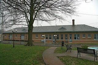
Tazewell is a town in Tazewell County, Virginia, United States. The population was 4,627 at the 2010 census. It is part of the Bluefield, WV-VA micropolitan area, which has a population of 107,578. It is the county seat of Tazewell County.

<span class="mw-page-title-main">Rowlesburg, West Virginia</span> Town in West Virginia, United States

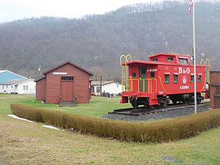
Rowlesburg is a town in southern Preston County, West Virginia, United States, along the Cheat River. The population was 438 at the 2020 census. It is part of the Morgantown metropolitan area. A former railroad town, it is home to the Downtown Rowlesburg Historic District, and was the site of action during the American Civil War.

<span class="mw-page-title-main">Terra Alta, West Virginia</span> Town in West Virginia, United States

Terra Alta is a town in eastern Preston County, West Virginia, United States. The population was 1,415 at the 2020 census. It is part of the Morgantown metropolitan area.

<span class="mw-page-title-main">St. Paul, Virginia</span> Town in Virginia, United States

St. Paul is a town in Russell and Wise counties in the U.S. state of Virginia. The population was 970 at the 2010 census. Virginia City Hybrid Energy Center, which powers 150,000 homes, is located in St. Paul.

<span class="mw-page-title-main">Tazewell County, Virginia</span> County in Virginia, United States

Tazewell County is a county located in the southwestern portion of the U.S. state of Virginia. As of the 2020 census, the population was 40,429. Its county seat is Tazewell.

References

  1. "New mayors elected in Richlands and Tazewell and liquor by the drink approved in Richlands" . Retrieved 9 February 2019.
  2. "2019 U.S. Gazetteer Files". United States Census Bureau. Retrieved August 7, 2020.
  3. 1 2 U.S. Geological Survey Geographic Names Information System: Richlands, Virginia
  4. 1 2 "U.S. Census website". United States Census Bureau . Retrieved 2008-01-31.
  5. Tennis, Joe (2004). Southwest Virginia Crossroads: An Almanac of Place Names And Places to See. Joe Tennis. ISBN   9781570722561.
  6. Brundage, William Fitzhugh (1993). Lynching in the New South: Georgia and Virginia, 1880 - 1930 . University of Illinois.
  7. "National Register Information System". National Register of Historic Places . National Park Service. July 9, 2010.
  8. "NowData – NOAA Online Weather Data". National Oceanic and Atmospheric Administration. Retrieved July 1, 2021.
  9. "Station: Richlands, VA". U.S. Climate Normals 2020: U.S. Monthly Climate Normals (1991-2020). National Oceanic and Atmospheric Administration. Retrieved July 1, 2021.
  10. "Census of Population and Housing". Census.gov. Retrieved June 4, 2015.
  11. Ratcliffe, Philip R. (2011). Mississippi John Hurt: His Life, His Times, His Blues. University Press of Mississippi. ISBN   9781617030093.
  12. "Richland Women Blues". Mississippi John Hurt Museum.
  13. "The Road Not Taken". Bruuuce.com. Retrieved April 16, 2018.
  14. "Michael Eugene Compton". databaseBasketball.com. Archived from the original on October 10, 2012. Retrieved November 10, 2012.