
A ZIP Code is a system of postal codes used by the United States Postal Service (USPS). Introduced on July 1, 1963, the basic format consisted of five digits. In 1983, an extended ZIP+4 code was introduced; it included the five digits of the ZIP Code, followed by a hyphen and four digits that designated a more specific location.

Tazewell County is a county in the U.S. state of Illinois. According to the 2020 census, it had a population of 131,343. Its county seat and largest city is Pekin. It is pronounced with a short "a", to rhyme with "razz" rather than "raze."

Tazewell County is a county located in the southwestern portion of the U.S. state of Virginia. As of the 2020 census, the population was 40,429. Its county seat is Tazewell.
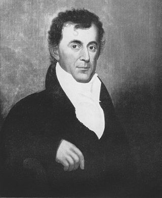
Littleton Waller Tazewell was a Virginia lawyer, plantation owner, and politician who served as U.S. Representative, U.S. Senator and the 26th Governor of Virginia, as well as a member of the Virginia House of Delegates.

Area code 276 is a telephone area code in the North American Numbering Plan (NANP) for the western part of the U.S. state of Virginia. It was established by a split of area code 540 on September 1, 2001.
Bishop is an unincorporated community located in McDowell County, West Virginia, and Tazewell County, Virginia, United States. Bishop lies on the Virginia-West Virginia state line at the intersection of West Virginia Route 16 and West Virginia Route 161.

Knotts Island is a marshy island and a small unincorporated community. The island is shared by Currituck County, North Carolina and Virginia Beach, Virginia, United States, bounded by the Currituck Sound, North Landing River, Back Bay, and Knotts Island Bay. Knotts Island is home to Mackay Island National Wildlife Refuge. Knotts Island is accessible overland from Virginia Beach using Princess Anne Road, or by water from the Currituck County mainland; the North Carolina Department of Transportation operates a free ferry between Knotts Island and Currituck on the mainland. The ZIP Code for Knotts Island is 27950.

State Route 16 is a primary state highway in the southwest part of the U.S. state of Virginia. It runs from the North Carolina border at North Carolina Highway 16 north to the West Virginia border at West Virginia Route 16, passing through the towns of Troutdale, Marion, and Tazewell. Highway 16 is part of a three-state route 16 that connects the Charlotte region with northwestern West Virginia.

State Route 61 is a primary state highway in the U.S. state of Virginia. The state highway runs 48.16 miles (77.51 km) from SR 16 in Tazewell east to U.S. Route 460 in Narrows. SR 61 passes through several narrow creek valleys as it parallels the West Virginia state line through Tazewell, Bland, and Giles counties. The only sizeable community between the highway's endpoints is Rocky Gap, where the highway meets US 52 and Interstate 77 (I-77).

Burke's Garden is an upland valley and unincorporated community in Tazewell County, Virginia.
Jewell Ridge is an unincorporated community and census-designated place in Tazewell County, Virginia, United States. Jewell Ridge is 6.3 miles (10.1 km) north of Richlands. Jewell Ridge has a post office with ZIP code 24622.
Maidsville is an unincorporated community in Monongalia County, West Virginia, United States. Maidsville is located along West Virginia Route 100, 4.5 miles (7.2 km) north-northwest of downtown Morgantown.

Amonate is an unincorporated community and census-designated place (CDP) in Tazewell County, Virginia, United States. Amonate is 8.5 miles (13.7 km) northwest of Tazewell. Its zip code is 24601. It was first listed as a CDP in the 2020 census with a population of 59.
Yards is an unincorporated community straddling the border between Tazewell County, Virginia and Mercer County, West Virginia, United States. Yards is located on the Bluestone River, 4 miles (6.4 km) northwest of Bluefield, Virginia. Yards had a post office on the Virginia side of the border from 1888 until May 28, 1994. The community was named for its railroad yards.
Mount Olive is an unincorporated community in Fayette County, West Virginia, United States. Mount Olive is 5.5 miles (8.9 km) north-northwest of Gauley Bridge. The town itself has no ZIP code; however, Mount Olive Correctional Complex, West Virginia's maximum-security state prison, is located near the town and has a post office with ZIP code 25185.
Rixeyville is an unincorporated community in Culpeper County, Virginia, United States. Rixeyville is located on Virginia State Route 229 7.4 miles (11.9 km) north of Culpeper. Rixeyville has a post office with ZIP code 22737, which opened on February 16, 1818.

Jenkins Bridge is an unincorporated community in Accomack County, Virginia, United States. Jenkins Bridge is located on Holdens Creek 3.6 miles (5.8 km) north-northwest of Hallwood. Jenkins Bridge had a post office until January 20, 2007; it still has its own ZIP code, 23399.
Horsepen is an unincorporated community in Tazewell County, Virginia, United States. Horsepen is located along the West Virginia state line 5.4 miles (8.7 km) north of Tazewell, Virginia. Horsepen has a post office with ZIP code 24619.

Bandy is an unincorporated community in Tazewell County, Virginia, United States. Bandy is located at the junction of State Routes 624 and 627, 3.4 miles (5.5 km) northeast of Richlands. Bandy has a post office with ZIP code 24602.
Doran is an unincorporated community and census-designated place in Tazewell County, Virginia, United States. Doran is located along the Clinch River, U.S. Route 460 and Virginia State Route 67 between Richlands and Raven. Doran has a post office with ZIP code 24612. The community was named for Joseph I. Doran, who was the general counsel for the Norfolk and Western Railway. It was first listed as a CDP in the 2020 census with a population of 113.

