White Stone, Virginia

Last updated

White Stone, Virginia
CentralWhiteStone.jpg
Central White Stone
VAMap-doton-WhiteStone.PNG
Location of White Stone, Virginia
Coordinates: 37°38′43″N76°23′28″W / 37.64528°N 76.39111°W / 37.64528; -76.39111
CountryUnited States
State Virginia
County Lancaster
Area
[1]
  Total0.98 sq mi (2.54 km2)
  Land0.98 sq mi (2.53 km2)
  Water0.00 sq mi (0.01 km2)
Elevation
49 ft (15 m)
Population
 (2020)
  Total380
  Density390/sq mi (150/km2)
Time zone UTC−5 (Eastern (EST))
  Summer (DST) UTC−4 (EDT)
ZIP code
22578
Area code 804
FIPS code 51-85600 [2]
GNIS feature ID1476645 [3]

White Stone is a town in Lancaster County, Virginia, United States. The population was 380 at the 2020 census. White Stone is one of many small towns located in Virginia's Northern Neck region. [4]

Contents

History

White Stone traces its earliest colonial history to the arrival of Epaphroditus Lawson, who was born in Yorkshire, a county in northern England. [5] In 1649-50, Epaphroditus acquired 4,600 acres of land along the Rappahannock River, including the present site of White Stone, where he lived until his death in 1652. [6] For many generations thereafter, the Lawson family "served the community as justices, sheriffs, and vestrymen." [7]

The town of White Stone was founded in 1715, and sits adjacent to the nearby towns of Lancaster and Kilmarnock. [4] However, White Stone was not incorporated until 1953. [4] There are a variety of theories about how White Stone got its distinctive name: one story has the name derived from a nearby stream, where locals would use a white stone to hone their tools. Another story has the town's name deriving from an 1819 church deed, which identified a property boundary as being "near the road leading by the white stone." [6]

The area was involved in the War of 1812 and the Civil War. [8] During the latter conflict, the historic plantation home of Pop Castle was bombarded by a Union gunboat. Pop Castle would later be listed on the National Register of Historic Places in 1989. [9]

Following the Civil War, White Stone had developed a small, thriving business community, including a general store, choral hall, and a hat-maker. [10] By 1921, Albert Terry Wright served as principal for the county's first school for black American students. [11]

Ultimately, the city of White Stone's "heyday" was during the late 19th and early 20th century, with the population having stagnated since the American Census of 1960, the first taken after the town's incorporation. [10] Today, White Stone remains a small, rural town, with a focus on tourism: the area is home to a local seafood market, the Allure Art Center, and other attractions. [12] Additionally, the town has recently received state and federal grants to develop a sewer system and to revitalize its business district. [13] [14]

Geography

White Stone is located at 37°38′43″N76°23′28″W / 37.64528°N 76.39111°W / 37.64528; -76.39111 (37.645182, 76.391242). [15]

According to the United States Census Bureau, the town has a total area of 1.0 square miles (2.6 km2), all of it land.

Historical population
CensusPop.Note
1960 395
1970 381−3.5%
1980 4097.3%
1990 372−9.0%
2000 358−3.8%
2010 352−1.7%
2020 3808.0%
U.S. Decennial Census [16]

Demographics

Racial composition as of 2020 (NH = Non-Hispanic)
Race / EthnicityPop 2020% 2020
White alone (NH)28274.21%
Black or African American alone (NH)6617.37%
Native American or Alaska Native alone (NH)10.26%
Asian alone (NH)51.32%
Pacific Islander alone (NH)00.00%
Some Other Race alone (NH)00.00%
Mixed Race/Multi-Racial (NH)133.42%
Hispanic or Latino (any race)133.42%
Total380100.00%

Note: the US Census treats Hispanic/Latino as an ethnic category. This table excludes Latinos from the racial categories and assigns them to a separate category. Hispanics/Latinos can be of any race.

As of the census [2] of 2000, there were 358 people, 163 households, and 101 families living in the town. The population density was 362.1 people per square mile (139.6/km2). There were 187 housing units at an average density of 189.2 per square mile (72.9/km2). The racial makeup of the town was 86.31% White, 10.34% African American, 2.23% Asian, 0.28% from other races, and 0.84% from two or more races. Hispanic or Latino of any race were 0.84% of the population.

There were 163 households, out of which 27.0% had children under the age of 18 living with them, 52.1% were married couples living together, 8.0% had a female householder with no husband present, and 38.0% were non-families. 32.5% of all households were made up of individuals, and 22.1% had someone living alone who was 65 years of age or older. The average household size was 2.20 and the average family size was 2.73.

In the town, the population was spread out, with 19.8% under the age of 18, 7.0% from 18 to 24, 25.4% from 25 to 44, 26.0% from 45 to 64, and 21.8% who were 65 years of age or older. The median age was 42 years. For every 100 females, there were 88.4 males. For every 100 females aged 18 and over, there were 82.8 males.

The median income for a household in the town was $28,125, and the median income for a family was $31,875. Males had a median income of $31,500 versus $22,000 for females. The per capita income for the town was $17,835. About 6.7% of families and 13.9% of the population were below the poverty line, including 24.7% of those under age 18 and 20.3% of those age 65 or over.

Related Research Articles

<span class="mw-page-title-main">Randolph County, Alabama</span> County in Alabama, United States

Randolph County is a county on the central eastern border of the U.S. state of Alabama. As of the 2020 census, the population was 21,967. Its county seat is Wedowee. Its name is in honor of John Randolph, a member of the United States Senate from Virginia. Randolph County was a prohibition or dry county until 2012, when the citizens of Randolph County voted to repeal prohibition.

<span class="mw-page-title-main">Willow Street, Pennsylvania</span> Census-designated place in Pennsylvania, United States

Willow Street is an unincorporated community and census-designated place (CDP) in Lancaster County, Pennsylvania, United States. The population was 7,578 at the 2010 census. In the early part of the 20th century, the main thoroughfare in town was lined with willow trees on both sides for the length of the town, hence the community's name. As time passed and the town grew, the road was widened and sidewalks were installed, which required the trees be removed. Only a few of the original trees remain to this day.

<span class="mw-page-title-main">Richmond County, Virginia</span> County in Virginia, United States

Richmond County is a county located on the Northern Neck in the U.S. state of Virginia. As of the 2020 census, the population sits at 8,923. Its county seat is Warsaw. The rural county should not be confused with the large city and state capital Richmond, Virginia. It was formed in 1692 when the first Rappahannock County was divided to form Richmond County and Essex County.

<span class="mw-page-title-main">Middlesex County, Virginia</span> County in Virginia, United States

Middlesex County is a county located on the Middle Peninsula in the U.S. state of Virginia. As of the 2020 census, the population was 10,625. Its county seat is Saluda.

<span class="mw-page-title-main">Lancaster County, Virginia</span> County in Virginia, United States

Lancaster County is a county located on the Northern Neck in the Commonwealth of Virginia. As of the 2020 census, the population sits at 10,919. Its county seat is Lancaster.

<span class="mw-page-title-main">Essex County, Virginia</span> County in Virginia, United States

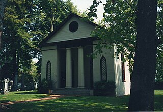
Essex County is a county located in the Middle Peninsula in the U.S. state of Virginia; the peninsula is bordered by the Rappahannock River on the north and King and Queen County on the south. As of the 2020 census, the population was 10,599. Its county seat is Tappahannock.

<span class="mw-page-title-main">Camp Pendleton South, California</span> Census-designated place in California, United States

Camp Pendleton South is a census-designated place (CDP) in San Diego County, California, located at the southwest corner of the Marine Corps Base Camp Pendleton. The population was 10,616 at the 2010 census, up from 8,854 at the 2000 census. Much of the population are residents of Camp Pendleton barracks situated in the area, as well as housing communities for married Marine and Navy personnel and their families. It, along with Camp Pendleton Mainside CDP, is one of two CDPs on the base.

<span class="mw-page-title-main">Magnolia, Minnesota</span> Town in Minnesota, United States

Magnolia is a town in Rock County, Minnesota, United States. The population was 222 at the 2010 census. According to the United States Census Bureau, the city has a total area of 0.78 square miles (2.02 km2), all land.

<span class="mw-page-title-main">Colerain Township, Lancaster County, Pennsylvania</span> Township in Pennsylvania, United States

Colerain Township is a township in southeastern Lancaster County, Pennsylvania, United States. The population was 3,883 at the 2020 census, an increase over the figure of 3,635 tabulated in 2010. It is part of the Solanco School District.

<span class="mw-page-title-main">Paradise Township, Lancaster County, Pennsylvania</span> Township in Pennsylvania, United States

Paradise Township is a township that is located in east-central Lancaster County, Pennsylvania, United States. The population was 5,696 at the time of the 2020 census.

<span class="mw-page-title-main">Reamstown, Pennsylvania</span> Census-designated place in Pennsylvania, United States

Reamstown is an unincorporated community and census-designated place (CDP) in Lancaster County, Pennsylvania, United States. The population was 3,361 at the 2010 census.

<span class="mw-page-title-main">West Lampeter Township, Pennsylvania</span> Township in Pennsylvania, United States

West Lampeter Township is a township that is located in central Lancaster County, Pennsylvania, United States. The population was 17,365 at the time of the 2020 census.

<span class="mw-page-title-main">Laceyville, Pennsylvania</span> Borough in Pennsylvania, United States

Laceyville is a borough that is located in Wyoming County, Pennsylvania, United States. The population was 363 at the time of the 2020 census.

<span class="mw-page-title-main">Port Royal, Virginia</span> Town in Virginia, United States

Port Royal is an incorporated town in Caroline County, Virginia, United States. The population was 126 at the 2010 census.

<span class="mw-page-title-main">Tappahannock, Virginia</span> Town in Virginia, United States

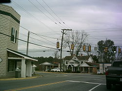
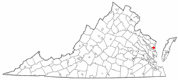
Tappahannock is the oldest town in Essex County, Virginia, United States. The population was 2,375 at the 2010 census, up from 2,068 at the 2000 census. Located on the Rappahannock River, Tappahannock is the county seat of Essex County. Its name comes from an Algonquian language word lappihanne, meaning "Town on the rise and fall of water" or "where the tide ebbs and flows." The Rappahannock is a tidal estuary from above this point and downriver to its mouth on Chesapeake Bay.

<span class="mw-page-title-main">Irvington, Virginia</span> Town in Virginia, United States

Irvington is a town on the Rappahannock River in Lancaster County, Virginia, United States. The population was 432 at the 2010 census. Located on a peninsula known as the Northern Neck, it has been designated a historic district.

<span class="mw-page-title-main">Warsaw, Virginia</span> Town in Virginia, United States

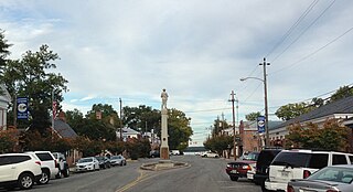
Warsaw is an incorporated town in and the county seat of Richmond County, Virginia, United States. The population was 1,637 at the 2020 census and is estimated to be 2,281 as of 2022.

<span class="mw-page-title-main">Worthington, West Virginia</span> Town in West Virginia, United States

Worthington is a town in Marion County, West Virginia, United States. The population was 158 at the 2010 census. Worthington was incorporated in 1893 and named for Colonel George Worthington, an early settler. U.S. Route 19 passes through the town.

<span class="mw-page-title-main">West Liberty, West Virginia</span> Town in West Virginia, United States

West Liberty is a town in Ohio County, West Virginia, United States. The population was 1,557 at the 2020 census. It is part of the Wheeling metropolitan area.

<span class="mw-page-title-main">Kilmarnock, Virginia</span> Town in Virginia, United States

Kilmarnock is a town in Lancaster and Northumberland counties in the U.S. Commonwealth of Virginia. The population was 1,487 at the 2010 census. It is located near the mouth of the Rappahannock River and is located within the Northern Neck George Washington Birthplace American Viticultural Area winemaking appellation. There is a small hospital in the town. Lancaster Middle School, grades 4–8, is also located in town. Approximately 500 students attend the school.

References

  1. "2019 U.S. Gazetteer Files". United States Census Bureau. Retrieved August 7, 2020.
  2. 1 2 "U.S. Census website". United States Census Bureau . Retrieved January 31, 2008.
  3. "US Board on Geographic Names". United States Geological Survey. October 25, 2007. Retrieved January 31, 2008.
  4. 1 2 3 "White Stone - VIrginia is for Lovers". www.virginia.org. Retrieved March 8, 2023.
  5. "Epaphroditus Lawson b. 1607 Brough Hall, Catterick, Yorkshire, England d. 2 Jun 1652 Lancaster County, Virginia - Inventory: Early Colonial Settlers of Southern Maryland and Virginia's Northern Neck Counties". www.colonial-settlers-md-va.us. Retrieved March 8, 2023.
  6. 1 2 Sabo, Matt (October 15, 2018). "The Comeback of White Stone". The Local Scoop. Retrieved March 8, 2023.
  7. "Lawsons of White Stone and Lawson Bay Farm 1650 to the Present Day (Robison)". Lancaster VA Historical Society-Mary Ball Washington Museum Library. Retrieved March 8, 2023.
  8. "051-0075 Pop Castle". www.dhr.virginia.gov. Retrieved March 19, 2023.
  9. "National Register Information System". National Register of Historic Places . National Park Service. July 9, 2010.
  10. 1 2 Sabo, Matt (October 15, 2018). "The Comeback of White Stone". The Local Scoop. Retrieved March 19, 2023.
  11. "A. T. Wright High School Historical Marker". www.hmdb.org. Retrieved March 19, 2023.
  12. "White Stone - VIrginia is for Lovers". www.virginia.org. Retrieved March 19, 2023.
  13. "White Stone Revitalization" . Retrieved March 19, 2023.
  14. "Looking Forward in White Stone". Rural Development. April 27, 2016. Retrieved March 19, 2023.
  15. "US Gazetteer files: 2010, 2000, and 1990". United States Census Bureau. February 12, 2011. Retrieved April 23, 2011.
  16. "Census of Population and Housing". Census.gov. Retrieved June 4, 2015.