Waverly, Virginia

Last updated

Waverly, Virginia
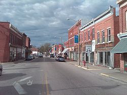
Waverly VA.jpg
Downtown Waverly
VAMap-doton-Waverly.PNG
Location of Waverly, Virginia
Coordinates: 37°2′2″N77°5′43″W / 37.03389°N 77.09528°W / 37.03389; -77.09528
CountryUnited States
State Virginia
County Sussex
Area
[1]
  Total3.08 sq mi (7.99 km2)
  Land3.08 sq mi (7.99 km2)
  Water0.00 sq mi (0.00 km2)
Elevation
112 ft (34 m)
Population
 (2020)
  Total1,955
  Density630/sq mi (240/km2)
Time zone UTC−5 (Eastern (EST))
  Summer (DST) UTC−4 (EDT)
ZIP codes
23890-23891
Area code 804
FIPS code 51-83600 [2]
GNIS feature ID1500286 [3]
Website Official website

Waverly is an incorporated town in Sussex County, Virginia, United States. Per the 2020 census, the population was 1,955. [4]

Contents

History

Popular legend has it that William Mahone (1826–1895), builder of the Norfolk and Petersburg Railroad (now Norfolk Southern), and his cultured wife, Otelia Butler Mahone (1837–1911), traveled along the newly completed Norfolk and Petersburg Railroad naming stations. Otelia was reading Ivanhoe , a book written by Sir Walter Scott. From his historical Scottish novels, Otelia chose the place names of Waverly, as well as Windsor and Wakefield. She tapped the Scottish Clan "McIvor" for the name of Ivor, a small town in neighboring Southampton County. When they could not agree, it is said that they invented a new name in honor of their dispute, which is how the tiny community of Disputanta a few miles west of Waverly was named. The N&P railroad was completed in 1858.

William Mahone became a Major General in the Confederate Army during the American Civil War, and later, a Senator in the United States Congress. A large portion of U.S. Route 460 between Petersburg and Suffolk is named in his honor.

Waverly is the second largest of the towns Gen. Mahone founded. Waverly has supplied the most state senators and delegate members to the Virginia General Assembly of any Virginia town under 3,000 people. They are Junius Edgar West, Delegate (1910–1912) and Senator (1912–1918); Thomas H. Howerton, Delegate (1912–1914); William O. Rogers, Senator (1924–1934); Garland "Peck" Gray, Senator (1942–1945 and 1948–1971); and Elmon T. Gray, Senator (1971–1992).

The Miles B. Carpenter House, Hunting Quarter, and Waverly Downtown Historic District are listed on the National Register of Historic Places. [5]

One of the last lynchings in Virginia happened in Waverly in 1925, when a black man was arrested for allegedly attacking a married white woman and stealing a pistol belonging to her husband. An armed mob of approximately 500 descended on the jail, seized the man, and then strung him up a tree, shot him, and burned him. [6] The following day, Governor E. Lee Trinkle arrived in Waverly and admonished citizens. [6] Negative publicity surrounding the event and the lynching of another black man in Wytheville, Virginia in 1926, led to anti-lynching legislation. [7]

On February 24, 2016, an EF1 tornado moved directly through Waverly, killing three, as verified by the Virginia Department of Game and Inland Fisheries. The storm also caused significant damage to the town, destroying mobile homes, and damaging homes, businesses, trees, and power poles and lines. [8] [9] This was all part of a massive storm system that moved rapidly across the region. [10]

Geography

According to the United States Census Bureau, the town has a total area of 3.1 square miles (8.0 km2), all of it land.

Demographics

Historical population
CensusPop.Note
1880 170
1900 493
1910 1,064115.8%
1920 1,30622.7%
1930 1,3553.8%
1940 1,288−4.9%
1950 1,50216.6%
1960 1,6016.6%
1970 1,7177.2%
1980 2,28433.0%
1990 2,223−2.7%
2000 2,3093.9%
2010 2,149−6.9%
2020 1,955−9.0%
U.S. Decennial Census [11]
2010 [12] 2020 [13]

2020 census

Waverly town, Virginia – Racial and Ethnic Composition
(NH = Non-Hispanic)
Note: the US Census treats Hispanic/Latino as an ethnic category. This table excludes Latinos from the racial categories and assigns them to a separate category. Hispanics/Latinos may be of any race.
Race / EthnicityPop 2010 [12] Pop 2020 [13] % 2010% 2020
White alone (NH)64052429.78%26.80%
Black or African American alone (NH)1,3901,31064.68%67.01%
Native American or Alaska Native alone (NH)150.05%0.26%
Asian alone (NH)1100.51%0.00%
Pacific Islander alone (NH)040.00%0.20%
Some Other Race alone (NH)150.05%0.26%
Mixed Race/Multi-Racial (NH)23551.07%2.81%
Hispanic or Latino (any race)83523.86%2.66%
Total2,1491,955100.00%100.00%

2010 Census

As of the 2010 United States Census, there were 2,149 people living in the town. The racial makeup of the town was 64.7% Black, 29.8% White, 0.0% Native American, 0.5% Asian, 0.0% from some other race and 1.1% from two or more races. 3.9% were Hispanic or Latino of any race.

As of the census [2] of 2000, there were 2,309 people, 880 households, and 570 families living in the town. The population density was 752.6 people per square mile (290.4/km2). There were 960 housing units at an average density of 312.9 per square mile (120.7/km2). The racial makeup of the town was 36.73% White, 61.76% African American, 0.13% Native American, 0.04% Asian, 0.48% from other races, and 0.87% from two or more races. Hispanic or Latino of any race were 1.17% of the population.

There were 880 households, out of which 29.8% had children under the age of 18 living with them, 40.1% were married couples living together, 20.7% had a female householder with no husband present, and 35.2% were non-families. 31.0% of all households were made up of individuals, and 12.7% had someone living alone who was 65 years of age or older. The average household size was 2.47 and the average family size was 3.09.

In the town, the population was spread out, with 25.4% under the age of 18, 6.0% from 18 to 24, 26.6% from 25 to 44, 23.4% from 45 to 64, and 18.6% who were 65 years of age or older. The median age was 40 years. For every 100 females, there were 88.2 males. For every 100 females age 18 and over, there were 80.4 males.

The median income for a household in the town was $33,698, and the median income for a family was $39,792. Males had a median income of $27,414 versus $21,279 for females. The per capita income for the town was $14,848. About 11.7% of families and 15.7% of the population were below the poverty line, including 21.4% of those under age 18 and 17.7% of those age 65 or over.
Notable people

See also

Related Research Articles

<span class="mw-page-title-main">Calhoun County, Alabama</span> County in Alabama, United States

Calhoun County is a county in the east central part of the U.S. state of Alabama. As of the 2020 census, the population was 116,441. Its county seat is Anniston. It was named in honor of John C. Calhoun, noted politician and US Senator from South Carolina.

<span class="mw-page-title-main">Chambers County, Alabama</span> County in Alabama, United States

Chambers County is a county located in the east central portion of the U.S. state of Alabama. As of the 2020 census the population was 34,772. Its county seat is LaFayette. Its largest city is Valley. Its name is in honor of Henry H. Chambers, who served as a United States Senator from Alabama.

<span class="mw-page-title-main">Etowah County, Alabama</span> County in Alabama, United States

Etowah County is a county located in the northeastern part of the U.S. state of Alabama. As of the 2020 census the population was 103,436. Its county seat is Gadsden. Its name is from a Cherokee word meaning "edible tree". In total area, it is the smallest county in Alabama, but one of the most densely populated. Etowah County comprises the Gadsden Metropolitan Statistical Area.

<span class="mw-page-title-main">Southampton County, Virginia</span> County in Virginia, United States

Southampton County is a county located on the southern border of the Commonwealth of Virginia. North Carolina is to the south. As of the 2020 census, the population was 17,996. Its county seat is Courtland.

<span class="mw-page-title-main">Prince George County, Virginia</span> County in Virginia, United States

Prince George County is a county located in the Commonwealth of Virginia. As of the 2020 census, the population was 43,010. Its county seat is Prince George.

<span class="mw-page-title-main">Halifax County, Virginia</span> County in Virginia, United States

Halifax County is a county located in the Commonwealth of Virginia. As of the 2020 census, the population was 34,022. Its county seat is Halifax.

<span class="mw-page-title-main">Mooresville, Indiana</span> Town in Indiana, United States

Mooresville is a town in Brown Township, Morgan County, in the U.S. state of Indiana. As of the 2020 census, the town population was 9,411.

<span class="mw-page-title-main">Princess Anne, Maryland</span> Town in Maryland, United States

Princess Anne is a town in Somerset County, Maryland, United States, that also serves as its county seat. Its population was 3,290 at the 2010 census. It is included in the Salisbury, Maryland–Delaware Metropolitan Statistical Area.

<span class="mw-page-title-main">Lula, Mississippi</span> Town in Mississippi, United States

Lula is a town in Coahoma County, Mississippi, United States. Per the 2020 census, the population was 204.

Sycamore is a town in Allendale County, South Carolina, United States. The population was 180 as of the 2010 census. On April 5, 2022, the town was hit by an EF3 tornado, although it had weakened to EF1 strength by the time it moved through town and only minor damage occurred. One person was injured by this tornado south of Allendale, South Carolina.

<span class="mw-page-title-main">Laguna Heights, Texas</span> Census-designated place in Texas, United States

Laguna Heights is a census-designated place (CDP) in Cameron County, Texas, United States. The population was 3,488 at the 2010 census.

<span class="mw-page-title-main">Bowie, Texas</span> City in Montague County, Texas, US

Bowie is a town in Montague County, Texas, United States. The population was 5,218 at the 2010 census.

<span class="mw-page-title-main">Dendron, Virginia</span> Town in Virginia, United States

Dendron is a town in Surry County, Virginia, United States. The population was 251 at the 2010 census. Sculptor Leslie Garland Bolling was born in Dendron, as was mayor of Hopewell, Virginia, Curtis W. Harris.

<span class="mw-page-title-main">Wakefield, Virginia</span> Town in Virginia, United States

Wakefield is an incorporated town in Sussex County, Virginia, United States. Per the 2020 census, the population was 729.

<span class="mw-page-title-main">Northfork, West Virginia</span> Town in West Virginia, United States

Northfork is a town in McDowell County, West Virginia, United States, located on U.S. Route 52 between Welch and Bluefield.

<span class="mw-page-title-main">Sophia, West Virginia</span> Town in West Virginia, United States

Sophia is a town in Raleigh County, West Virginia, United States. It was incorporated in 1912. The population was 1,124 at the 2020 census.

<span class="mw-page-title-main">Ottawa, Wisconsin</span> Town in Wisconsin, United States

Ottawa is a town in Waukesha County, Wisconsin, United States. The population was 3,646 at the 2020 census.

<span class="mw-page-title-main">Verona, Wisconsin</span> City in Wisconsin, United States

Verona is a city in Dane County, Wisconsin, in the United States and is a suburb of Madison. The population was 14,030 at the 2020 census. The city is located ten miles southwest of downtown Madison within the Town of Verona. It is part of the Madison Metropolitan Statistical Area.

<span class="mw-page-title-main">Wausaukee, Wisconsin</span> Village in Wisconsin, United States

Wausaukee is a village in Marinette County, Wisconsin, in the United States. The population was 575 at the 2010 census. The village is part of the Marinette, WI–MI Micropolitan Statistical Area.

<span class="mw-page-title-main">Sussex County, Virginia</span> County in Virginia, United States

Sussex County is a rural county located in the Commonwealth of Virginia. As of the 2020 census, the population was 10,829. Its county seat is Sussex. It was formed in 1754 from Surry County. The county is named after the county of Sussex, England.

References

  1. "2019 U.S. Gazetteer Files". United States Census Bureau. Retrieved August 7, 2020.
  2. 1 2 "U.S. Census website". United States Census Bureau . Retrieved January 31, 2008.
  3. "US Board on Geographic Names". United States Geological Survey. October 25, 2007. Retrieved January 31, 2008.
  4. "Waverley town, Virginia". United States Census Bureau . Retrieved December 25, 2022.
  5. "National Register Information System". National Register of Historic Places . National Park Service. July 9, 2010.
  6. 1 2 "Memories of 1925 lynching linger in Waverly".
  7. "Anti-Lynching Law of 1928 – Encyclopedia Virginia".
  8. Virginia Event Report: EF1 Tornado (Report). National Centers for Environmental Information. National Weather Service Weather Forecast Office in Wakefield, Virginia. 2016. Retrieved May 29, 2016.
  9. Virginia Event Report: EF1 Tornado (Report). National Centers for Environmental Information. National Weather Service Weather Forecast Office in Wakefield, Virginia. 2016. Retrieved May 29, 2016.
  10. Staff, Web (February 24, 2016). "3 killed, significant damage seen after reported tornado hits Waverly". WTVR. Tribune Broadcasting. Retrieved February 24, 2016.
  11. "Decennial Census by Decade". US Census Bureau.
  12. 1 2 "P2 HISPANIC OR LATINO, AND NOT HISPANIC OR LATINO BY RACE - 2010: DEC Redistricting Data (PL 94-171) - Waverly town, Virginia". United States Census Bureau .
  13. 1 2 "P2 HISPANIC OR LATINO, AND NOT HISPANIC OR LATINO BY RACE - 2020: DEC Redistricting Data (PL 94-171) - Waverly town, Virginia". United States Census Bureau .
  14. "Shirley MacLaine". Yahoo Movies. Retrieved February 25, 2016.