Appomattox, Virginia

Last updated

Appomattox, Virginia
Town of Appomattox
Appomattox Court House, VA, Theater IMG 4179.JPG
The Appomattox Theater in July 2011.
Seal of Appomattox, Virginia.png
USA Virginia location map.svg
Red pog.svg
Appomattox
Location of Appomattox
Usa edcp location map.svg
Red pog.svg
Appomattox
Appomattox (the United States)
Coordinates: 37°21′32″N78°49′35″W / 37.35889°N 78.82639°W / 37.35889; -78.82639
CountryFlag of the United States.svg United States
State Flag of Virginia.svg  Virginia
County Flag of Appomattox County, Virginia.png Appomattox
Area
[1]
  Total2.20 sq mi (5.71 km2)
  Land2.19 sq mi (5.68 km2)
  Water0.01 sq mi (0.02 km2)
Elevation
850 ft (259 m)
Population
 (2010)
  Total1,733
  Estimate 
(2019) [2]
1,794
  Density817.31/sq mi (315.60/km2)
Time zone UTC−5 (Eastern (EST))
  Summer (DST) UTC−4 (EDT)
ZIP code
24522
Area code 434
FIPS code 51-02072 [3]
GNIS feature ID1498448 [4]
Website townofappomattox.com

Appomattox is a town in Appomattox County, Virginia, United States. The population was 1,733 at the 2010 census. It is the county seat of Appomattox County. [5]

Contents

Appomattox is part of the Lynchburg Metropolitan Statistical Area.

History

The Appomattox Visitor Center in July 2011 Appomattox, VA, Visitor Center IMG 4184.JPG
The Appomattox Visitor Center in July 2011

The town is named for the Appomattox River, which was named after the Appomattoc Native American tribe, one of the Algonquian-speaking Powhatan Confederacy, historically based in the coastal area and encountered by the English before the tribes of the Piedmont. The Appamatuck historically lived somewhat to the east of the present town, around the area of present-day Petersburg. At the time of European encounter, the area of Appomattox County above the Fall Line was part of the territory of the Manahoac tribe, who spoke a Siouan language.

At the time of the Civil War, the present community of Appomattox was the site of a railroad depot, called Appomattox Station on the line between Petersburg and Lynchburg, a stop on the Southside Railroad. [6] The station is three miles west of the restored historic village of Appomattox Court House, the site of Confederate General Robert E. Lee's surrender to Union General Ulysses S. Grant on April 9, 1865, which essentially ended the American Civil War. The area is preserved as Appomattox Court House National Historical Park and is administered by the National Park Service.

The town was first named "Nebraska" in 1855. In 1895 it was renamed "West Appomattox". The first postmaster of "Nebraska, Virginia", was Samuel D. McDearmon. [7]

Near the end of the Civil War, Robert E. Lee made a last attempt to reach the depot, hoping to transport the Army of Northern Virginia south by railroad to meet Joseph E. Johnston's larger Army of Tennessee, then located in Greensboro, North Carolina. The arrival of Federal troops and their blocking Lee's army from the depot led to Lee's surrender in the home of Wilmer McLean, on April 9. Johnston later surrendered 98,270 Confederate troops (the largest surrender of the war) on April 26, 1865.

Today, each April, the Appomattox Court House National Historical Park commemorates this event with a luminary ceremony, wherein a lantern is lit for each of the 4,600 slaves freed in Appomattox County alone.

The railroad became the Atlantic, Mississippi and Ohio Railroad in 1870. The inconvenience of the railroad's location to the original Appomattox Court House in the village of Clover Hill led to the decline of the courthouse community. After fire destroyed the courthouse building in 1892, the county relocated the court to the depot area, which formally became the county seat in 1894. The railroad became a line in the Norfolk and Western Railway and then the Norfolk Southern Railway.

In 1990, there were 11,971 residents reported for Appomattox County; the Town of Appomattox had 1,703 residents.

In addition to Appomattox Court House National Historical Park, the Appomattox River Bridge, Appomattox Historic District, Holiday Lake 4-H Educational Center, and Holliday Lake State Park are listed on the National Register of Historic Places. [8]

The 2010 Appomattox shootings occurred from January 17 to 20 and left eight people dead.

Geography

Appomattox is located at 37°21′32″N78°49′35″W / 37.35889°N 78.82639°W / 37.35889; -78.82639 (37.358973, 78.826438). [9]

According to the United States Census Bureau, the town has a total area of 2.2 square miles (5.6 km2).

Demographics

Historical population
CensusPop.Note
1930 704
1940 99240.9%
1950 1,09410.3%
1960 1,1848.2%
1970 1,40018.2%
1980 1,345−3.9%
1990 1,70726.9%
2000 1,7613.2%
2010 1,733−1.6%
2019 (est.)1,794 [2] 3.5%
U.S. Decennial Census [10]

As of the census [3] of 2000, there were 1,761 people, 716 households, and 469 families residing in the town. The population density was 808.7 people per square mile (311.9/km2). There were 767 housing units at an average density of 352.2/sq mi (135.8/km2). The racial makeup of the town was 66.89% White, 32.14% African American, 0.28% Native American, 0.11% from other races, and 0.57% from two or more races. Hispanic or Latino of any race were 0.23% of the population.

There were 716 households, out of which 29.3% had children under the age of 18 living with them, 42.7% were married couples living together, 20.0% had a female householder with no husband present, and 34.4% were non-families. 30.4% of all households were made up of individuals, and 17.2% had someone living alone who was 65 years of age or older. The average household size was 2.35 and the average family size was 2.92.

In the town, the population was spread out, with 23.9% under the age of 18, 8.6% from 18 to 24, 27.4% from 25 to 44, 20.8% from 45 to 64, and 19.2% who were 65 years of age or older. The median age was 39 years. For every 100 females, there were 82.3 males. For every 100 females age 18 and over, there were 75.2 males.

The median income for a household in the town was $24,167, and the median income for a family was $29,188. Males had a median income of $26,515 versus $20,732 for females. The per capita income for the town was $14,355. About 20.9% of families and 18.4% of the population were below the poverty line, including 26.4% of those under age 18 and 22.9% of those age 65 or over.

Government

Town Council

Notable people

Climate

The climate in this area is characterized by hot, humid summers and generally mild to cool winters. According to the Köppen Climate Classification system, Appomattox has a humid subtropical climate, abbreviated "Cfa" on climate maps. [13]

Climate data for Appomattox, Virginia (1991–2020 normals, extremes November 1961–present)
MonthJanFebMarAprMayJunJulAugSepOctNovDecYear
Record high °F (°C)78
(26)
80
(27)
89
(32)
93
(34)
92
(33)
98
(37)
103
(39)
103
(39)
98
(37)
96
(36)
83
(28)
79
(26)
103
(39)
Mean daily maximum °F (°C)44.9
(7.2)
49.2
(9.6)
56.7
(13.7)
68.1
(20.1)
74.9
(23.8)
82.4
(28.0)
86.1
(30.1)
84.2
(29.0)
78.0
(25.6)
68.4
(20.2)
57.2
(14.0)
48.4
(9.1)
66.5
(19.2)
Daily mean °F (°C)35.9
(2.2)
39.0
(3.9)
45.8
(7.7)
56.1
(13.4)
64.1
(17.8)
72.5
(22.5)
76.4
(24.7)
74.7
(23.7)
68.3
(20.2)
57.6
(14.2)
46.8
(8.2)
39.4
(4.1)
56.4
(13.6)
Mean daily minimum °F (°C)26.8
(−2.9)
28.7
(−1.8)
35.0
(1.7)
44.2
(6.8)
53.3
(11.8)
62.6
(17.0)
66.7
(19.3)
65.2
(18.4)
58.6
(14.8)
46.7
(8.2)
36.3
(2.4)
30.4
(−0.9)
46.2
(7.9)
Record low °F (°C)−20
(−29)
−7
(−22)
2
(−17)
16
(−9)
25
(−4)
35
(2)
45
(7)
44
(7)
34
(1)
18
(−8)
8
(−13)
−8
(−22)
−20
(−29)
Average precipitation inches (mm)3.54
(90)
2.79
(71)
3.95
(100)
3.56
(90)
4.65
(118)
3.80
(97)
4.08
(104)
3.55
(90)
4.64
(118)
3.91
(99)
3.63
(92)
4.10
(104)
46.20
(1,173)
Average snowfall inches (cm)3.2
(8.1)
3.2
(8.1)
2.8
(7.1)
0.1
(0.25)
0.0
(0.0)
0.0
(0.0)
0.0
(0.0)
0.0
(0.0)
0.0
(0.0)
0.0
(0.0)
0.0
(0.0)
2.0
(5.1)
11.3
(29)
Average precipitation days (≥ 0.01 in)8.47.39.39.410.99.610.09.18.38.17.79.2107.3
Average snowy days (≥ 0.1 in)1.30.80.80.10.00.00.00.00.00.00.02.011.3
Source: NOAA [14] [15]

Notes:

    Notes

      Related Research Articles

      <span class="mw-page-title-main">Prince Edward County, Virginia</span> County in Virginia, United States

      Prince Edward County is located in the Commonwealth of Virginia. As of the 2020 census, the population was 21,849. Its county seat is Farmville.

      <span class="mw-page-title-main">Petersburg, Virginia</span> Independent city in Virginia, United States

      Petersburg is an independent city in the Commonwealth of Virginia in the United States. As of the 2020 census, the population was 33,458 with a majority black American. The Bureau of Economic Analysis combines Petersburg with Dinwiddie County for statistical purposes. The city is 21 miles (34 km) south of the commonwealth (state) capital city of Richmond.

      <span class="mw-page-title-main">Nottoway County, Virginia</span> County in Virginia, United States

      Nottoway County is a county located in the Commonwealth of Virginia. As of the 2020 census, the population was 15,642. Its county seat is Nottoway. It is situated south of the James River, thus making it a part of the Southside Virginia Region.

      <span class="mw-page-title-main">Emporia, Virginia</span> Independent city in Virginia, United States

      Emporia is an independent city in the Commonwealth of Virginia, surrounded by Greensville County, United States. Emporia and a predecessor town have been the county seat of Greensville County since 1791. As of the 2020 census, the population was 5,766, making it the third-least populous city in Virginia. The Bureau of Economic Analysis combines the city of Emporia with surrounding Greensville County for statistical purposes.

      <span class="mw-page-title-main">Appomattox County, Virginia</span> County in Virginia, United States

      Appomattox County is a United States county located in the Piedmont region and near the center of the Commonwealth of Virginia. The county is part of the Lynchburg, VA Metropolitan Statistical Area, and its county seat is the town of Appomattox.

      <span class="mw-page-title-main">Columbus, Kentucky</span> City in Kentucky, United States

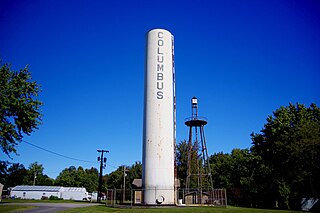
      Columbus is a home rule-class city in Hickman County, Kentucky, in the United States. The population was 140 at the 2020 census, a decline from 229 in 2000. The city lies at the western end of the state, less than a mile from the Mississippi River.

      <span class="mw-page-title-main">Danbury, North Carolina</span> City in North Carolina, United States

      Danbury is a city located in Danbury Township, Stokes County, North Carolina, United States. As of the 2020 census, the city had a total population of 142. It is the county seat of Stokes County. Danbury is located on North Carolina Highway 8/89 approximately 20 miles (32 km) north of Winston-Salem and is the "Gateway to Hanging Rock". The Stokes County Government Center, Arts Council, school board, county jail, a public library, a post office, and other public services are found within the town limits. LifeBrite Community Hospital of Stokes is located about a half mile northwest of the town. North Stokes High School, a big part of town, is located 7.4 miles to the northwest.

      <span class="mw-page-title-main">Matoaca, Virginia</span> CDP in Virginia, United States

      Matoaca is a census-designated place (CDP) in Chesterfield County, Virginia, United States. The population was 2,403 at the 2010 census. It is named after the Pamunkey princess Matoaka who was better known by her nickname "Pocahontas". It was near the site of an Appomattoc village Matoka or Matoks, which was reputedly her girlhood home, and the palace town of the weroansqua Oppussoquionuske.

      <span class="mw-page-title-main">Blackstone, Virginia</span> Town in Virginia, United States

      Blackstone, formerly named Blacks and Whites, and then Bellefonte, is a town in Nottoway County in the U.S. state of Virginia. The population was 3,621 at the 2010 census.

      <span class="mw-page-title-main">Burkeville, Virginia</span> Town in Virginia, United States

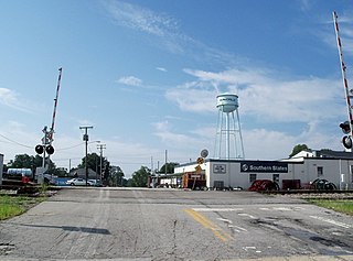
      Burkeville is an incorporated town in Nottoway County, Virginia, United States. The population was 432 at the 2010 census. The source of the town name is disputed. The town is located at the crossroads of U.S. routes 360 and 460.

      <span class="mw-page-title-main">Crewe, Virginia</span> Town in Virginia, United States

      Crewe is a town in Nottoway County, Virginia, United States. The population was 2,262 at the 2020 census.

      <span class="mw-page-title-main">Wise, Virginia</span> Town in Virginia, United States

      Wise is a town in Wise County, Virginia. The population was 3,286 at the 2010 census. It is the county seat of Wise County. It was originally incorporated as the town of Gladeville in 1874. The town's name was changed to Wise in 1924, after Henry A. Wise, the last Virginia governor before the American Civil War and the first governor to hail from the Eastern Shore of Virginia.

      <span class="mw-page-title-main">Romney, West Virginia</span> Town in West Virginia, United States

      Romney is a town in and the county seat of Hampshire County, West Virginia, United States. The population was 1,722 at the 2020 census. It is part of the Winchester, Virginia metropolitan area. The town was established in 1762 along with Shepherdstown; together, they are the two oldest towns in West Virginia.

      <span class="mw-page-title-main">Rowlesburg, West Virginia</span> Town in West Virginia, United States

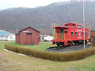
      Rowlesburg is a town in southern Preston County, West Virginia, United States, along the Cheat River. The population was 438 at the 2020 census. It is part of the Morgantown metropolitan area. A former railroad town, it is home to the Downtown Rowlesburg Historic District, and was the site of action during the American Civil War.

      <span class="mw-page-title-main">Morrisville, North Carolina</span> Town in North Carolina, United States

      Morrisville is a town located primarily in Wake County, North Carolina, United States. According to the 2020 census, the population was 29,630. Morrisville is part of the Research Triangle metropolitan region. The regional name originated after the 1959 creation of the Research Triangle Park, located midway between the cities of Raleigh and Durham. The Research Triangle region encompasses the Raleigh-Durham-Cary, NC Combined Statistical Area. The population of the Raleigh-Durham-Cary, NC Combined Statistical Area was 2,106,463 in 2020, while the population of the Raleigh-Cary, NC Metropolitan Statistical Area was 1,413,982 in 2020. The operational headquarters of Lenovo is located in the municipal limits.

      <span class="mw-page-title-main">Pamplin City, Virginia</span> Town in Virginia, United States

      Pamplin City is a town in Appomattox and Prince Edward counties in the U.S. state of Virginia. The population was 138 at the 2020 United States census.

      <span class="mw-page-title-main">Farmville, Virginia</span> Town in Virginia, United States

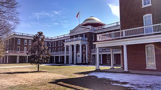
      Farmville is a town in Prince Edward and Cumberland counties in the Commonwealth of Virginia. The population was 7,473 at the 2020 census. It is the county seat of Prince Edward County.

      <span class="mw-page-title-main">Gordonsville, Virginia</span> Town in Virginia, United States

      Gordonsville is a town in Orange County in the Commonwealth of Virginia in the United States. Located about 19 miles northeast of Charlottesville and 65 miles northwest of Richmond, the population was 1,402 at the 2020 census.

      <span class="mw-page-title-main">Appomattox Court House National Historical Park</span> 1,700 acres in Virginia (US) managed by the National Park Service

      The Appomattox Court House National Historical Park is the preserved 19th-century village named Appomattox Court House in Appomattox County, Virginia. The village was named for the presence nearby of what is now preserved as the Old Appomattox Court House. The village is the site of the Battle of Appomattox Court House, and contains the McLean House, where the surrender of the Army of Northern Virginia under Robert E. Lee to Union commander Ulysses S. Grant took place on April 9, 1865, an event widely symbolic of the end of the American Civil War. The village itself began as the community of Clover Hill, which was made the county seat of Appomattox County in the 1840s. The village of Appomattox Court House entered a stage of decline after it was bypassed by a railroad in 1854. In 1930, the United States War Department was authorized to erect a monument at the site, and in 1933 the War Department's holdings there was transferred to the National Park Service. The site was greatly enlarged in 1935, and a restoration of the McLean House was planned but was delayed by World War II. In 1949, the restored McLean House was reopened to the public. Several restored buildings, as well as a number of original 19th-century structures are situated at the site.

      <span class="mw-page-title-main">Concord, Campbell County, Virginia</span> Census-designated place in Virginia, United States

      Concord is a census-designated place (CDP) in Appomattox and Campbell counties in the U.S. state of Virginia. The population as of the 2010 census was 1,458.

      References

      1. "2019 U.S. Gazetteer Files". United States Census Bureau. Retrieved August 7, 2020.
      2. 1 2 "Population and Housing Unit Estimates". United States Census Bureau. May 24, 2020. Retrieved May 27, 2020.
      3. 1 2 "U.S. Census website". United States Census Bureau . Retrieved January 31, 2008.
      4. "US Board on Geographic Names". United States Geological Survey. October 25, 2007. Retrieved January 31, 2008.
      5. "Find a County". National Association of Counties. Archived from the original on May 31, 2011. Retrieved June 7, 2011.
      6. Bright, David L. (2015). "Confederate Railroads - South Side". Confederate Railroads. Retrieved January 25, 2018.
      7. "Appomattox town history". Archived from the original on May 3, 2008. Retrieved January 11, 2009.
      8. "National Register Information System". National Register of Historic Places . National Park Service. July 9, 2010.
      9. "US Gazetteer files: 2010, 2000, and 1990". United States Census Bureau. February 12, 2011. Retrieved April 23, 2011.
      10. "Census of Population and Housing". Census.gov. Retrieved June 4, 2015.
      11. "Abbitt, Watkins Moorman (1908-1998)". Project Vote Smart. Retrieved November 4, 2012.
      12. "Larry Robinson". pro-football-reference.com. Retrieved October 10, 2015.
      13. Climate Summary for Appomattox, Virginia
      14. "NowData – NOAA Online Weather Data". National Oceanic and Atmospheric Administration. Retrieved July 2, 2021.
      15. "Station: Appomattox, VA". U.S. Climate Normals 2020: U.S. Monthly Climate Normals (1991-2020). National Oceanic and Atmospheric Administration. Retrieved July 2, 2021.