Iron Gate, Virginia

Last updated

Iron Gate, Virginia
CSX 1 (1834377743).jpg
A CSX freight train passes through Iron Gate in 2007.
Nickname: 
IG
Motto: 
Gateway to the Alleghany Highlands
VAMap-doton-IronGate.PNG
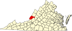
Location of Iron Gate, Virginia
Coordinates: 37°47′55″N79°47′28″W / 37.79861°N 79.79111°W / 37.79861; -79.79111
Country United States
State Virginia
County Alleghany
Government
  Type Mayor–council
   Mayor Gary A. Craig
   Vice Mayor Richard Erskine
Area
  Total0.35 sq mi (0.90 km2)
  Land0.33 sq mi (0.86 km2)
  Water0.02 sq mi (0.05 km2)
Elevation
1,037 ft (316 m)
Population
 (2020)
  Total324
  Density930/sq mi (360/km2)
Time zone UTC-5 (Eastern (EST))
  Summer (DST) UTC-4 (EDT)
ZIP Code
24448
Area code(s) 540 and 826
FIPS code 51-40024 [1]
GNIS feature ID1493127 [2]

Iron Gate is a town in eastern Alleghany County, Virginia, United States. The population was 324 at the 2020 census. The town is located along U.S. Route 220, near Clifton Forge.

Contents

History

The Town of Iron Gate was incorporated in 1889. The town's founding was a direct result of the Iron Age. During the 1880s, iron mines began opening in Alleghany County and the Alleghany Iron and Ore Company opened its blast furnace in the northern end of Iron Gate. The proximity to the railroad made the site of Iron Gate an optimal location. Many men were employed by the company until 1919 when operations ceased. [3]

Geography

Iron Gate is located at 37°47′55″N79°47′28″W / 37.79861°N 79.79111°W / 37.79861; -79.79111 (37.798484, -79.791219). [4]

According to the United States Census Bureau, the town has a total area of 0.3 square miles (0.9 km²), all of it land. Iron Gate is also where the head waters of the James River arise.

Climate

The climate in this area has mild differences between highs and lows, and there is adequate rainfall year-round. According to the Köppen Climate Classification system, Iron Gate has a marine west coast climate, abbreviated "Cfb" on climate maps. [5]

Demographics

Historical population
CensusPop.Note
1890 199
1900 39297.0%
1910 60053.1%
1920 69916.5%
1930 77711.2%
1940 719−7.5%
1950 7250.8%
1960 716−1.2%
1970 692−3.4%
1980 620−10.4%
1990 417−32.7%
2000 404−3.1%
2010 388−4.0%
2020 324−16.5%
Source: U.S. Census Bureau

2020 census

As of the census of 2020, there were 324 people residing in the town. There were 170 housing units. The racial makeup of the town was 87.3% White, 5.2% African American or Black, 0.3% American Indian, 0.3% Asian, 0.0% Pacific Islander, 0.0% from other races, and 6.8% from two or more races. Hispanic or Latino of any race were 1.5% of the population.

2010 census

As of the census of 2010, there were 388 people residing in the town. There were 183 housing units. The racial makeup of the town was 94.8% White, 3.9% Black or African American, 0.0% Native American, 0.0% Asian, 0.3% Pacific Islander, 0.0% from other races, and 1.0% from two or more races. 1.0% of the population were Hispanic or Latino of any race.

2000 census

At the 2000 census there were 404 people, 185 households, and 121 families living in the town. The population density was 1,170.6 people per square mile (445.7/km²). There were 197 housing units at an average density of 570.8 per square mile (217.3/km²). The racial makeup of the town was 94.55% White, 5.20% African American, and 0.25% from two or more races. [1] Of the 185 households 17.3% had children under the age of 18 living with them, 54.6% were married couples living together, 7.6% had a female householder with no husband present, and 34.1% were non-families. 31.9% of households were one person and 17.8% were one person aged 65 or older. The average household size was 2.18 and the average family size was 2.73.

The age distribution was 16.6% under the age of 18, 8.2% from 18 to 24, 24.0% from 25 to 44, 27.5% from 45 to 64, and 23.8% 65 or older. The median age was 46 years. For every 100 females, there were 96.1 males. For every 100 females aged 18 and over, there were 94.8 males.

The median household income was $26,094 and the median family income was $34,464. Males had a median income of $27,222 versus $17,500 for females. The per capita income for the town was $16,703. About 7.4% of families and 9.9% of the population were below the poverty line, including 8.8% of those under age 18 and 13.7% of those age 65 or over.

Economy

Iron Gate is predominately a bedroom community of Clifton Forge and Covington. Garten Trucking operates a large trucking terminal and warehouse in the town.

Recreation

The Virginia Department of Wildlife Resources maintains a public access point to the James River south of the town limits. The Iron Gate public access point is one of twelve that make up the Upper James River Water Trail, a blueway along the James River.

Government

Iron Gate operates a Mayor–council form of government. Iron Gate Town Council is composed of a mayor and six council members who are elected at-large.

Education

Iron Gate is served by Alleghany County Public Schools. Public school students residing in Iron Gate are zoned to attend Sharon Elementary School, Clifton Middle School (until 2023), and Alleghany High School.

Mountain Gateway Community College in nearby Clifton Forge is the closest higher education institution to the town.

Infrastructure

Public safety

Law enforcement is provided by the Alleghany County Sheriff's Office. Fire protection is provided by the Iron Gate Volunteer Fire Department which operates a fire station within the town. Emergency medical services are provided by the Iron Gate Volunteer Fire Department and Clifton Forge Rescue Squad.

Transportation

Air

Ingalls Field, located near Hot Springs is the closest general aviation airport to the town. The Greenbrier Valley Airport and Roanoke-Blacksburg Regional Airport are the closest airports with commercial service.

Roads

Rail

The CSX operated James River Subdivision runs through the town. The closest passenger rail service is located in Clifton Forge.

Related Research Articles

<span class="mw-page-title-main">Covington, Virginia</span> Independent city in Virginia, United States

Covington is an independent city in the Commonwealth of Virginia. As of the 2020 census, the population was 5,737, making it the second-least populous city in Virginia. It is surrounded by Alleghany County, of which it is also the county seat. Located at the confluence of Jackson River and Dunlap Creek, Covington is one of three cities in the Roanoke Regional Partnership. The Bureau of Economic Analysis combines the city of Covington with Alleghany county for statistical purposes.

<span class="mw-page-title-main">Clifton Forge, Virginia</span> Town in Virginia, United States

Clifton Forge is a town in Alleghany County, Virginia, United States which is part of the greater Roanoke Region. The population was 3,555 at the 2020 census. The Jackson River flows through the town, which as a result was once known as Jackson's River Station.

<span class="mw-page-title-main">Botetourt County, Virginia</span> County in Virginia, United States

Botetourt County is a US county that lies in the Roanoke Region of the Commonwealth of Virginia. Located in the mountainous portion of the state, the county is bordered by two major ranges, the Blue Ridge Mountains and the Appalachian Mountains.

<span class="mw-page-title-main">Alleghany County, Virginia</span> County in Virginia, United States

Alleghany County is an American county located on the far western edge of Commonwealth of Virginia. It is bordered by the Allegheny Mountains, from which the county derives its name, and it is the northernmost part of the Roanoke Region. The county seat is Covington. As of the 2020 census, the population was 15,223.

<span class="mw-page-title-main">Iron River, Michigan</span> City in Michigan, United States

Iron River is a city in Iron County in the U.S. state of Michigan. As of the 2020 census, the city population was 3,007. The city is situated at the southeast corner of Iron River Township, but is administratively autonomous. Iron River is the birthplace and home of four-time US Olympian and 2022 gold medalist Nick Baumgartner.

<span class="mw-page-title-main">Low Moor, Virginia</span> Census-designated place in Virginia, United States

Low Moor is a census-designated place (CDP) in Alleghany County, Virginia. The population was 258 at the 2010 census.

<span class="mw-page-title-main">Selma, Virginia</span> CDP in Virginia, United States

Selma is a census-designated place (CDP) in Alleghany County, Virginia, United States. The population was 529 at the 2010 census.

North Shore is a census-designated place (CDP) in Franklin County, Virginia, United States. The community lies along State Route 616. It is part of the Roanoke Metropolitan Statistical Area.

<span class="mw-page-title-main">Goshen, Virginia</span> Town in Virginia, United States

Goshen is a town in Rockbridge County, Virginia, United States. The population was 361 in the 2010 census.

<span class="mw-page-title-main">Belington, West Virginia</span> City in West Virginia

Belington is a town in Barbour County, West Virginia, United States, situated along the Tygart Valley River. The population was 1,804 as of the 2020 census.

<span class="mw-page-title-main">White Sulphur Springs, West Virginia</span> City in West Virginia, United States

White Sulphur Springs is a city in Greenbrier County in southeastern West Virginia, United States. The population was 2,231 at the 2020 census. The city emblem consists of five dandelion flowers and the citizens celebrate spring with an annual Dandelion Festival.

<span class="mw-page-title-main">Henderson, West Virginia</span> Unincorporated Town in West Virginia, United States

Henderson is an unincorporated community and former town in Mason County, West Virginia, United States, at the confluence of the Ohio and Kanawha Rivers. The population was 231 at the 2020 census. It is part of the Point Pleasant, WV–OH Micropolitan Statistical Area. The town was incorporated in 1893 and named for Samuel Bruce Henderson, who owned the townsite at the time. The town was unincorporated following a public hearing on August 11, 2022.

<span class="mw-page-title-main">Piedmont, West Virginia</span> Town in West Virginia, United States

Piedmont is a town in Mineral County, West Virginia, United States. It is part of the Cumberland, MD-WV metropolitan statistical area. The population was 716 at the 2020 census. Piedmont was chartered in 1856 and the town is the subject of Colored People: A Memoir by Piedmont native Henry Louis Gates Jr.

<span class="mw-page-title-main">Granville, West Virginia</span> Town in West Virginia

Granville is a town in Monongalia County, West Virginia, United States. The population was 1,355 at the 2020 census. It is included in the Morgantown metropolitan area.

<span class="mw-page-title-main">Albright, West Virginia</span> Town in West Virginia, United States

Albright is a town in central Preston County, West Virginia, United States, along the Cheat River. The population was 260 at the 2020 census. A former coal town, it is part of the Morgantown metropolitan area.

<span class="mw-page-title-main">Rowlesburg, West Virginia</span> Town in West Virginia, United States

Rowlesburg is a town in southern Preston County, West Virginia, United States, along the Cheat River. The population was 438 at the 2020 census. It is part of the Morgantown metropolitan area. A former railroad town, it is home to the Downtown Rowlesburg Historic District, and was the site of action during the American Civil War.

<span class="mw-page-title-main">Davis, West Virginia</span> Town in West Virginia, United States

Davis is a town in Tucker County, West Virginia, United States, situated along the Blackwater River. The population was 595 at the 2020 census.

<span class="mw-page-title-main">Hambleton, West Virginia</span> Town in West Virginia, United States

Hambleton is a town in Tucker County, West Virginia, United States. The population was 216 at the 2020 census. Hambleton was established in 1889, but not incorporated until 1905. It was named by then United States Senator Stephen B. Elkins in honor of a stockholder by this name in the West Virginia Central Railroad Company. The town was previously known as Hulings.

<span class="mw-page-title-main">Gates, Oregon</span> City in Oregon, United States

Gates is a city on the border of Linn and Marion counties in Oregon, United States. The population was 548 at the 2020 census. The greater part of Gates' population is in Marion County and the city is primarily under Marion County's jurisdiction.

Glen Wilton is a census-designated place (CDP) in northern Botetourt County, Virginia, United States. The population was 129 at the 2020 census. The CDP is located along the James River, between Eagle Rock and Iron Gate. It is part of the Roanoke Metropolitan Statistical Area.

References

  1. 1 2 "U.S. Census website". United States Census Bureau . Retrieved January 31, 2008.
  2. U.S. Geological Survey Geographic Names Information System: Iron Gate, Virginia
  3. "The History of the Town of Iron Gate". Town of Iron Gate. Retrieved November 2, 2022.
  4. "US Gazetteer files: 2010, 2000, and 1990". United States Census Bureau. February 12, 2011. Retrieved April 23, 2011.
  5. Climate Summary for Iron Gate, Virginia