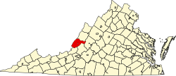
Rich Patch Mines, Virginia

Last updated

Rich Patch Mines is an unincorporated community in Alleghany County, Virginia, United States.

Alleghany County, Virginia county in Virginia, United States

Alleghany County is an American county located on the far western edge of Commonwealth of Virginia. It is bordered by the Allegheny Mountains, from which the county derives its name, and it is the northernmost part of the Roanoke Region. The county seat is Covington.

Virginia State of the United States of America

Virginia, officially the Commonwealth of Virginia, is a state in the Southeastern and Mid-Atlantic regions of the United States located between the Atlantic Coast and the Appalachian Mountains. Virginia is nicknamed the "Old Dominion" due to its status as the first English colonial possession established in mainland North America and "Mother of Presidents" because eight U.S. presidents were born there, more than any other state. The geography and climate of the Commonwealth are shaped by the Blue Ridge Mountains and the Chesapeake Bay, which provide habitat for much of its flora and fauna. The capital of the Commonwealth is Richmond; Virginia Beach is the most populous city, and Fairfax County is the most populous political subdivision. The Commonwealth's estimated population as of 2017 is over 8.4 million.

United States federal republic in North America

The United States of America (USA), commonly known as the United States or America, is a country composed of 50 states, a federal district, five major self-governing territories, and various possessions. At 3.8 million square miles, the United States is the world's third or fourth largest country by total area and is slightly smaller than the entire continent of Europe's 3.9 million square miles. With a population of over 327 million people, the U.S. is the third most populous country. The capital is Washington, D.C., and the largest city by population is New York City. Forty-eight states and the capital's federal district are contiguous in North America between Canada and Mexico. The State of Alaska is in the northwest corner of North America, bordered by Canada to the east and across the Bering Strait from Russia to the west. The State of Hawaii is an archipelago in the mid-Pacific Ocean. The U.S. territories are scattered about the Pacific Ocean and the Caribbean Sea, stretching across nine official time zones. The extremely diverse geography, climate, and wildlife of the United States make it one of the world's 17 megadiverse countries.

Related Research Articles

Thompsonville, Illinois Village in Illinois, United States

Thompsonville is a village in Franklin County, Illinois, United States. The population was 543 at the 2010 census.

Allegany Township, Potter County, Pennsylvania Township in Pennsylvania, United States

Allegany Township is a township in Potter County, Pennsylvania, United States. The population was 402 at the 2000 census.

Rodopi Peak

Rodopi Peak is an ice-covered peak rising to approximately 500 m in Delchev Ridge, Tangra Mountains, eastern Livingston Islandin the South Shetland Islands, Antarctica.

Moscow Institute of Electronics and Mathematics

Moscow Institute of Electronics and Mathematics, MIEM — Russian higher educational institution in the field of electronics, computer engineering, and applied mathematics. Founded in 1962 as Moscow Institute of Electronic Machine Building, in 2011 joined with National Research University Higher School of Economics.

Ventarron cultural heritage site in Peru

Ventarrón is the site of a 4,500-year-old temple with painted murals, which was excavated in Peru in 2007 near Chiclayo, in the Lambayeque region on the northern coast. The site was inhabited by the Early Cupisnique, Cupisnique, Chavin and Moche cultures.

Lipiny, Hajnówka County Village in Podlaskie, Poland

Lipiny is a village in the administrative district of Gmina Hajnówka, within Hajnówka County, Podlaskie Voivodeship, in north-eastern Poland, close to the border with Belarus. It lies approximately 5 kilometres (3 mi) north-east of Hajnówka and 51 km (32 mi) south-east of the regional capital Białystok.

Manordeilo is a village in Carmarthenshire, Wales.

Alpout, Lachin Place in Lachin, Azerbaijan

Alpout is a village in the Lachin Rayon of Azerbaijan.

Bronisławki, Gostyń County Village in Greater Poland, Poland

Bronisławki is a village in the administrative district of Gmina Gostyń, within Gostyń County, Greater Poland Voivodeship, in west-central Poland. It lies approximately 7 kilometres (4 mi) west of Gostyń and 59 km (37 mi) south of the regional capital Poznań.

Smithflat, California Unincorporated community in California, United States

Smithflat is an unincorporated community in El Dorado County, California, USA. It lies 4 km (2.5 mi) east of Placerville and 7.2 km (4.5 mi) west of Camino at an elevation of 2224 feet.

Martins Ferry, California Former settlement in California, United States

Martins Ferry is a former settlement in Klamath County and later in Humboldt County, California. It lay on the Klamath River, at an elevation of 315 feet. It still appeared on maps as of 1983.

Hamzadere Dam is a dam in Turkey. The development was backed by the Turkish State Hydraulic Works.

Souani is a town and commune in Tlemcen Province in north-western Algeria.

Weber City, Fluvanna County is an unincorporated community in Fluvanna County, in the U.S. state of Virginia. One of the last remaining working Drive-In Movie Theaters in Virginia was in Weber City.

Kayoulah is an unincorporated community in Pulaski County, in the U.S. state of Virginia.

The APEX Museum is a museum of history presented from the black perspective. It is located on Auburn Avenue in the Sweet Auburn historic district of Atlanta, Georgia.

Jewish Museum in Oslo museum covering Jewish history in Norway

The Jewish Museum in Oslo aims at informing about Jews in Norway. It was established as a foundation in 2003, supported by the Det mosaiske trossamfunn and Oslo City Museum.

Davis Crossroads is an unincorporated community in Walker County, in the U.S. state of Georgia.

Wilson Corner, Indiana Unincorporated community in Indiana, United States

Wilson Corner is an unincorporated community in Shelby and Washington townships, Shelby County, in the U.S. state of Indiana.

Como is an unincorporated community in New Madrid County, in the U.S. state of Missouri.

References

Coordinates: 37°45′19″N79°54′59″W / 37.75528°N 79.91639°W / 37.75528; -79.91639

Geographic coordinate system Coordinate system

A geographic coordinate system is a coordinate system that enables every location on Earth to be specified by a set of numbers, letters or symbols. The coordinates are often chosen such that one of the numbers represents a vertical position and two or three of the numbers represent a horizontal position; alternatively, a geographic position may be expressed in a combined three-dimensional Cartesian vector. A common choice of coordinates is latitude, longitude and elevation. To specify a location on a plane requires a map projection.