Rocky Mount, Virginia

Last updated

Rocky Mount, Virginia
Town
Franklin County Courthouse Rocky Mount Virginia.JPG
Franklin County courthouse, built 1909
Rocky Mount Seal.jpg
Motto(s): 
Crescit eundo
It grows as it goes
VAMap-doton-RockyMount.PNG
Location of Rocky Mount in Franklin County
Coordinates: 36°59′44″N79°53′20″W / 36.99556°N 79.88889°W / 36.99556; -79.88889
CountryUnited States
State Virginia
County Franklin
Founded1786
Government
  MayorC. Holland Perdue III
Area
[1]
  Total6.85 sq mi (17.74 km2)
  Land6.82 sq mi (17.65 km2)
  Water0.04 sq mi (0.09 km2)
Elevation
1,200 ft (400 m)
Population
 (2020)
  Total4,903
  Density693.0/sq mi (267.58/km2)
Time zone UTC−5 (Eastern (EST))
  Summer (DST) UTC−4 (EDT)
ZIP code
24151
FIPS code 51-68496
GNIS feature ID1499983
Website www.rockymountva.org

Rocky Mount is a town in and the county seat of Franklin County, Virginia, United States. [2] The town is part of the Roanoke Metropolitan Statistical Area, and had a population of 4,903 as of the 2020 census. It is located in the Roanoke Region of Virginia. [3]

Contents

History

Robert Hill built a block house (fortified residence and trading post) in the 1740s, for trading with Native Americans. English settlers did not arrive until 1760. They named Rocky Mount for a steep cliff near the town. The area originally consisted of two adjacent villages, Rocky Mount and Mount Pleasant.

Washington Iron Furnace was built by James Callaway and Jeremiah Early; its site was on what is now Main Street. It was operated by Callaway's heirs and Peter Saunders until 1850, when it was damaged by a flood. Repairs and rebuilding were stopped by the breakout of Civil War.

The first court session was held at Rocky Mount in 1786 following the Revolutionary War. It was held in Callaway's home until he deeded land to the town on which to build the courthouse. The first was made of logs. Rocky Mount was assigned a post office in 1795.

The town was divided into lots in 1804. Jeremiah's son John Early represented the county (part-time) in the Virginia House of Delegates and served as sheriff. He operated a plantation nearby. The courthouse was replaced in 1831.

By 1836 the iron furnace employed 100 people. The town had about 275 residents; it had 30 houses and several businesses, including three grocery stores and a newspaper/printing office. The oldest dwelling is "Mount Pleasant", built overlooking the courthouse in 1829 for Caleb Tate (the court clerk for nearly 40 years, from 1797-1835). Its detached brick kitchen, built circa 1820, is the oldest building in town. The Rocky Mount Turnpike Company incorporated in 1846 and a bank was founded shortly afterward, but neither prospered. [4]

During the Civil War, numerous planter families from the Tidewater region sought refuge in Rocky Mount. Many brought numerous black American slaves with them, in part trying to ensure they did not escape to Union forces. Among these were the immediate past governor, Henry A. Wise, who settled his family here from his plantation on the Elizabeth River before he started serving as a Confederate general. Jubal Anderson Early, who became a Confederate general during the war, was born on a plantation nearby. Before the war, he served one term representing Franklin County in the Virginia House of Delegates and more than a decade as Commonwealth's attorney (prosecutor). After the war, he resumed his legal practice here and in Lynchburg, Virginia. His office building in Rocky Mount was demolished in 1937.

The only building constructed in that era that survives today was built for Dr. Thomas Greer in 1861. Two other buildings constructed in 1850-1854 and used as law offices still survive.

The town's clerk, Robert A. Scott, issued scrip to assist families of Confederate soldiers during the Civil War. The Confederate government requisitioned slaves from various planters in the county to work on Richmond's defenses. Rocky Mount had no battles, although Union Gen. George Stoneman and troops passed through the county in the war's final days.

In 1867, the Freedmen's Bureau under William F. DeKnight opened a Sunday school in Rocky Mount; about a third of the residents were black American freedmen. No day school was established for freedmen's children until much later. Booker Taliaferro Washington was born enslaved in Franklin County. After the war, his mother moved with him to the free state of West Virginia for his education. He later studied at the Hampton Institute, established in eastern Virginia for the education of blacks. [5]

The area's major cash crop both before and after the Civil War was tobacco. In 1873, Rocky Mount incorporated as a town and absorbed the smaller village of Mount Pleasant, establishing its present boundaries. [6] Former court clerk Robert Scott was elected as the first mayor.

Rocky Mount's population was about 400 people in 1870, 600 in 1897, and about 1100 in 1920. In 1880, the Franklin and Pittsylvania Railroad connected Rocky Mount to Danville and Lynchburg via Pittsylvania County, Virginia. Most of the buildings in town burned in a destructive fire in 1889.

Another railroad was constructed through town about 1892, and stimulated industrial and commercial development. The railroad (known as the Norfolk and Western Railway) was nicknamed the "Pumpkin Vine" because of its route between Roanoke, Virginia and Winston-Salem, North Carolina. Canadawas y Mills (a gristmill and box factory) was built in 1898.

Nathanial V. Angle, a former schoolteacher who became an entrepreneur, built the Bald Knob furniture factory in 1903. (It became the Lane Furniture Company in 1957 and is known as the MW Manufacturing Company in the 21st century). By World War I, N.V. Angle owned a furniture and grocery stores, a lumberyard, tobacco house, agricultural implement store, and the area's first Ford automobile dealership.

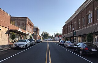
Much of the town's historic architecture, both residential and commercial, dates from the first decades of the 20th century. Only the Lodge Rooms (Colored), built in 1900, remains of the former thriving black American community on West Court Street. The furniture and textile workers needed housing, and contractors also built more elaborate (including Victorian-style) dwellings for managers and professionals. Rocky Mount is roughly halfway between Roanoke and Martinsville, Virginia, which likewise developed furniture manufacturing and textile industries early in the 20th century.

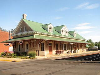
The present Franklin County courthouse was constructed in 1909 (two years after the Norfolk and Western freight and passenger station). It was modeled on the Roanoke County courthouse in Salem, Virginia.

The town's growth was reflected in construction of new churches. Trinity Episcopal Church and its Rectory were both built in 1874 and survived the 1889 fire. The church was moved back from Main Street in 1906. The African Methodist Episcopal Church, built before the fire, no longer exists. The Presbyterian Church (built by 1880) reopened shortly after the fire. The Methodists rebuilt their church of brick; they replace Scott Memorial Church again in 1925. The Baptist Church (colored) built in 1907 was later deconsecrated and became a business. The Bethel AME church, built before World War I, continues to be in active use.

A Coca-Cola bottling plant opened in town circa 1920. The area's oldest car dealership (Chevrolet) dates from 1926 (although housed in a building from 1916). Ryland Goode also established a car dealership for Dodges and Hudsons that year. The building for the International Harvester dealership dates from 1946; the John Deere dealership (built 1940) has been adapted for use as the county's Developmental Center. New industries continued to be established before World War II. Around 1940 Sealtest established a dairy bottling plant and Exchange Milling opened an animal feed processing plant. [7]

The Art Deco-style People's National Bank was built in 1928.

Public schools were segregated, and those for black students were underfunded. In 1915, Rocky Mount appropriated $2,200 to build an eight-room brick school for white students, complete with central heating and indoor plumbing. The same year black residents built Rocky Mount Colored School and dormitory, at their own expense, on Bald Knob outside the town limits. The town became a school district and in 1924 built a high school for white students. By 1940 the town's white students had 16 teachers.

Only seven black American teachers "struggled with the problems of their race in their own schools." [8] Around that time, a foundation was established to mark Booker T. Washington's birthplace. In 1952 it donated 6 acres of land on which to build a modern, four-room school for black students. That opened shortly before the start of Massive Resistance to school desegregation in Virginia. It was operated until 1966, when the U.S. Supreme Court found subsidies for segregated schools (much used by the county's white schoolchildren) to be unconstitutional. This structure has been adapted for use as an administrative building of the National Park Service. [9]

Rocky Mount's brick Municipal Building was built in 1929. The Works Progress Administration of the President Franklin D. Roosevelt administration built the United States Post Office in 1936, during the Great Depression. The county jail was built in the Art Moderne style in 1938, also a depression project.

Investment in infrastructure was increased by the federal government. The town applied for funds to upgrade its sewer system. The New Deal project with most effects may have been work on U.S. Route 220 and state route 40 near the town. The WPA and prominent local businessman N. V. Angle drained a swamp and developed the land for Mary Elizabeth Park, named for Angle's wife. It is now maintained by the local Presbyterian church (although Angle was a Methodist).

Before World War II, Rocky Mount's industries included a silk mill and a door and sash window factory, in addition to Angle's furniture company.

The library, constructed in 1940, was one of ten funded by an anonymous donor in rural Virginia counties in that era. It now serves as an administration building. The county's administration building, built in 1967, is along the same street and is named for Virgil Goode Sr., former Virginia House delegate and Commonwealth's attorney. In 1990, local residents saved the former Norfolk and Western station. It has been redeveloped as a tourist information center. [10]

The Booker T. Washington National Monument, Evergreen-Callaway-Deyerle House, The Farm, Greer House, Rocky Mount Historic District, Washington Iron Furnace, and Woods-Meade House are listed on the National Register of Historic Places. [11]

Geography

Rocky Mount is located at the center of Franklin County at 36°59′59″N79°53′23″W / 36.99972°N 79.88972°W / 36.99972; -79.88972 (36.999855, 79.889673). [12] U.S. Route 220 passes through the east side of town as a limited-access bypass, leading north 23 miles (37 km) to Roanoke and south 26 miles (42 km) to Martinsville. Virginia State Route 40 passes through the center of Rocky Mount as Pell Avenue and Franklin Street, leading east 32 miles (51 km) to Gretna and southwest 10 miles (16 km) to Ferrum.

According to the United States Census Bureau, the town has a total area of 6.9 square miles (17.8 km2), of which 0.03 square miles (0.07 km2), or 0.39%, is water. [13] The Pigg River, an east-flowing tributary of the Roanoke River, forms the southern border of the town. The 1,934-foot (589 m) summit of Grassy Hill is in the northern part of town.

Climate

The climate in this area is characterized by hot, humid summers and generally mild to cool winters. According to the Köppen Climate Classification system, Rocky Mount has a humid subtropical climate, abbreviated "Cfa" on climate maps. [14]

Climate data for Rocky Mount, Virginia (1991–2020 normals, extremes 1894–present)
MonthJanFebMarAprMayJunJulAugSepOctNovDecYear
Record high °F (°C)80
(27)
81
(27)
92
(33)
96
(36)
101
(38)
103
(39)
103
(39)
101
(38)
100
(38)
98
(37)
95
(35)
82
(28)
103
(39)
Mean daily maximum °F (°C)47.0
(8.3)
50.8
(10.4)
58.8
(14.9)
69.6
(20.9)
76.2
(24.6)
83.2
(28.4)
86.6
(30.3)
85.2
(29.6)
78.6
(25.9)
69.7
(20.9)
59.1
(15.1)
50.0
(10.0)
67.9
(19.9)
Daily mean °F (°C)36.7
(2.6)
39.0
(3.9)
46.2
(7.9)
55.6
(13.1)
63.9
(17.7)
71.8
(22.1)
75.7
(24.3)
74.1
(23.4)
67.3
(19.6)
56.7
(13.7)
46.3
(7.9)
39.5
(4.2)
56.1
(13.4)
Mean daily minimum °F (°C)26.4
(−3.1)
27.2
(−2.7)
33.6
(0.9)
41.7
(5.4)
51.6
(10.9)
60.3
(15.7)
64.8
(18.2)
63.0
(17.2)
56.0
(13.3)
43.8
(6.6)
33.5
(0.8)
29.0
(−1.7)
44.2
(6.8)
Record low °F (°C)−11
(−24)
−5
(−21)
0
(−18)
12
(−11)
18
(−8)
27
(−3)
44
(7)
36
(2)
30
(−1)
15
(−9)
7
(−14)
−4
(−20)
−11
(−24)
Average precipitation inches (mm)3.88
(99)
3.11
(79)
3.99
(101)
4.07
(103)
4.49
(114)
4.86
(123)
4.49
(114)
4.10
(104)
5.00
(127)
3.40
(86)
3.66
(93)
4.13
(105)
49.18
(1,249)
Average snowfall inches (cm)3.6
(9.1)
4.9
(12)
2.5
(6.4)
0.2
(0.51)
0.0
(0.0)
0.0
(0.0)
0.0
(0.0)
0.0
(0.0)
0.0
(0.0)
0.0
(0.0)
0.0
(0.0)
1.4
(3.6)
12.6
(32)
Average precipitation days (≥ 0.01 in)9.98.910.311.012.311.013.111.610.38.78.89.9125.8
Average snowy days (≥ 0.1 in)2.01.40.90.10.00.00.00.00.00.00.01.15.5
Source: NOAA [15] [16]

Demographics

Historical population
CensusPop.Note
1880 315
1890 62899.4%
1900 612−2.5%
1910 96758.0%
1920 1,07611.3%
1930 1,33924.4%
1940 1,3662.0%
1950 1,4324.8%
1960 1,412−1.4%
1970 4,002183.4%
1980 4,1984.9%
1990 4,098−2.4%
2000 4,066−0.8%
2010 4,79918.0%
2020 4,9032.2%
U.S. Decennial Census [17]
State historical marker for Rocky Mount Rocky Mount Virginia state historical marker.JPG
State historical marker for Rocky Mount

2020 census

As of the census of 2020, there were 4,903 people and 2,063 households residing in the town. There were 2,307 housing units. The racial makeup of the town was 72.4% White, 20.3% Black, 0.2% American Indian, 1.4% Asian, 0.0% Pacific Islander, 2.0% from other races, and 3.7% from two or more races. Hispanic or Latino of any race were 3.6% of the population.

The median income for a household in the town was $46,021 and the median income for a family was $56,250.

2000 census

As of the census [18] of 2000, there were 4,066 people, 1,698 households, and 1,018 families residing in the town. The population density was 886.5 people per square mile (342.0/km2). There were 1,796 housing units at an average density of 391.6 per square mile (151.1/km2). The racial makeup of the town was 74.50% White, 22.26% African American, 0.27% Native American, 1.11% Asian, 0.10% Pacific Islander, 0.49% from other races, and 1.28% from two or more races. Hispanic or Latino of any race were 1.67% of the population.

There were 1,698 households, out of which 26.4% had children under the age of 18 living with them, 40.2% were married couples living together, 15.8% had a female householder with no husband present, and 40.0% were non-families. 36.5% of all households were made up of individuals, and 18.7% had someone living alone who was 65 years of age or older. The average household size was 2.21 and the average family size was 2.87.

In the town, the population was spread out, with 21.4% under the age of 18, 7.7% from 18 to 24, 25.2% from 25 to 44, 22.1% from 45 to 64, and 23.6% who were 65 years of age or older. The median age was 42 years. For every 100 females, there were 85.0 males. For every 100 females age 18 and over, there were 81.1 males.

The median income for a household in the town was $26,927, and the median income for a family was $38,688. Males had a median income of $30,947 versus $22,472 for females. The per capita income for the town was $16,207. About 16.6% of families and 14.1% of the population were below the poverty line, including 17.6% of those under age 18 and 14.0% of those age 65 or over.

Notable people

Further reading

Related Research Articles

<span class="mw-page-title-main">Salem, Virginia</span> Independent city in Virginia, United States

Salem is an independent city in the U.S. commonwealth of Virginia. As of the 2020 census, the population was 25,346. It is the county seat of Roanoke County, although the two are separate jurisdictions. The Bureau of Economic Analysis combines the city of Salem with Roanoke County, which surrounds both Salem and the neighboring City of Roanoke, for statistical purposes. Salem has its own courthouse and sheriff's office, but shares a jail with Roanoke County, which is located in the Roanoke County Courthouse complex in Salem. The Roanoke County Sheriff's Office and Roanoke County Department of Social Services are also located within Salem, though the county administrative offices are located in unincorporated Cave Spring.

<span class="mw-page-title-main">Roanoke County, Virginia</span> County in Virginia, United States

Roanoke County is a county located in the U.S. state of the Commonwealth of Virginia. As of the 2020 census, the population was 96,929. Its county seat is Salem, but the county administrative offices are located in the census-designated place of Cave Spring.

<span class="mw-page-title-main">Grayson County, Virginia</span> County in Virginia, United States

Grayson County is a county located in the southwestern part of the Commonwealth of Virginia. As of the 2020 census, the population was 15,333. Its county seat is Independence. Mount Rogers, the state's highest peak at 5,729 feet (1,746 m), is in Grayson County.

<span class="mw-page-title-main">Galax, Virginia</span> Independent city in Virginia, United States

Galax is an independent city in the southwestern part of the Commonwealth of Virginia. As of the 2020 census, the population was 6,720.

<span class="mw-page-title-main">Franklin County, Virginia</span> County in Virginia, United States

Franklin County is located in the Blue Ridge foothills of the Commonwealth of Virginia. As of the 2020 census, the population was 54,477. Its county seat is Rocky Mount. Franklin County is part of the Roanoke Metropolitan Statistical Area and is located in the Roanoke Region of Virginia. The Roanoke River forms its northeast boundary with Bedford County.

<span class="mw-page-title-main">Floyd County, Virginia</span> County in Virginia, United States

Floyd County is a county located in the Commonwealth of Virginia. As of the 2020 census, the population was 15,476. Its county seat is the town of Floyd. Floyd County is included in the Blacksburg-Christiansburg, VA Metropolitan Statistical Area. Named after Virginia politician John Floyd, the county was established in 1831. The county is located on the high plateau of the Blue Ridge Mountains and surrounded by the Little River. In the 1960s and 1970s, Floyd proved popular with people in the era's counterculture, particularly those who wanted to live in closer contact with nature.

<span class="mw-page-title-main">Emporia, Virginia</span> Independent city in Virginia, United States

Emporia is an independent city in the Commonwealth of Virginia, surrounded by Greensville County, United States. Emporia and a predecessor town have been the county seat of Greensville County since 1791. As of the 2020 census, the population was 5,766, making it the third-least populous city in Virginia. The Bureau of Economic Analysis combines the city of Emporia with surrounding Greensville County for statistical purposes.

<span class="mw-page-title-main">Mount Sterling, Kentucky</span> City in Kentucky, United States

Mount Sterling, often written as Mt. Sterling, is a home rule-class city in Montgomery County, Kentucky, United States. The population was 7,558 as of the 2020 census, up from 6,895 in 2010. It is the county seat of Montgomery County and the principal city of the Mount Sterling micropolitan area.

<span class="mw-page-title-main">Weldon, North Carolina</span> Town in North Carolina, United States

Weldon is a town in Halifax County, North Carolina, United States. The population was 1,655 at the 2010 census. It is part of the Roanoke Rapids, North Carolina Micropolitan Statistical Area.

<span class="mw-page-title-main">Plymouth, North Carolina</span> Town in North Carolina, United States

Plymouth is the largest town in Washington County, North Carolina, United States. The population was 3320 at the 2020 Census. It is the county seat of Washington County. Plymouth is located on the Roanoke River about seven miles (11 km) upriver from its mouth into the Albemarle Sound in North Carolina's Inner Banks region.

<span class="mw-page-title-main">Fincastle, Virginia</span> Town in Virginia, United States

Fincastle is a town in Botetourt County, Virginia, United States. The population was 755 at the 2020 census. It is the county seat of Botetourt County.

<span class="mw-page-title-main">Lawrenceville, Virginia</span> Town in Virginia, United States

Lawrenceville is a town in Brunswick County, Virginia, United States. Per the 2020 census, the population was 1,014. Located by the Meherrin River, it is the county seat of Brunswick County. In colonial times, Lieutenant Governor Alexander Spotswood had a stockade built nearby, called Fort Christanna, where converted Native American allies were housed and educated.

<span class="mw-page-title-main">Boones Mill, Virginia</span> Town in Virginia, United States

Boones Mill is a town in Franklin County, Virginia, United States. The population was 239 in 2018, down from 285 at the 2000 census. It is part of the Roanoke Metropolitan Statistical Area.

Penhook is a census-designated place (CDP) in Franklin County, Virginia, United States. The population was 801 at the 2010 census, up from 726 in 2000. It is part of the Roanoke Metropolitan Statistical Area.

<span class="mw-page-title-main">Independence, Virginia</span> Town in Virginia, United States

Independence is a town located in and the county seat of Grayson County, Virginia. At the 2020 U.S. census, it had a population of 1,001. It is situated on Virginia's Crooked Road, a heritage trail celebrating the musical heritage of Southwest Virginia.

<span class="mw-page-title-main">Christiansburg, Virginia</span> Town in Montgomery County, Virginia, USA

Christiansburg is a town in Montgomery County, Virginia, United States.The population was 21,041 at the 2010 census. It is the county seat of Montgomery County. Christiansburg, Blacksburg and the city of Radford are the three principal municipalities of the Blacksburg–Christiansburg Metropolitan Statistical Area, which encompasses those municipalities, all of Montgomery County, and three other counties.

<span class="mw-page-title-main">Orange, Virginia</span> Town in Virginia, United States

Orange is a town and the county seat of Orange County, Virginia, United States. The population was 5,062 at the 2020 census, representing a 7.2% increase since the 2010 census. Orange is 28 miles (45 km) northeast of Charlottesville, 88 miles (142 km) southwest of Washington, D.C., and 4 miles (6 km) east of Founding Father and fourth U.S. president James Madison's plantation of Montpelier.

<span class="mw-page-title-main">Franklin, West Virginia</span> Town in West Virginia, United States

Franklin is a town in and the county seat of Pendleton County, West Virginia, United States. The population was 486 at the 2020 census. Franklin was established in 1794 and named for Francis Evick, an early settler.

<span class="mw-page-title-main">Saltville, Virginia</span> Town in Virginia, United States

Saltville is a town in Smyth and Washington counties in the U.S. state of Virginia. The population was 2,077 at the 2010 census. It is part of the Kingsport–Bristol (TN)–Bristol (VA) Metropolitan Statistical Area, which is a component of the Johnson City–Kingsport–Bristol, TN-VA Combined Statistical Area – commonly known as the "Tri-Cities" region.

<span class="mw-page-title-main">Roanoke metropolitan area</span> Metropolitan area in Virginia, United States

The Roanoke Metropolitan Statistical Area is a Metropolitan Statistical Area (MSA) in Virginia as defined by the United States Office of Management and Budget (OMB). The Roanoke MSA is sometimes referred to as the Roanoke Valley, even though the Roanoke MSA occupies a larger area than the Roanoke Valley. It is geographically similar to the area known as the Roanoke Region of Virginia, but while the latter includes Alleghany County, the former does not. As of the 2020 census, the MSA had a population of 315,251.

References

  1. "2019 U.S. Gazetteer Files". United States Census Bureau. Retrieved August 7, 2020.
  2. "Find a County". National Association of Counties. Retrieved June 7, 2011.
  3. "Roanoke Regional Partnership". roanoke.org.
  4. Rocky Mount NRIS Section 7, pp. 3-4, 54-56
  5. NRIS pp. 57-58
  6. Frank H. Gille (ed.). The Encyclopedia of Virginia 1999; Volume One. Somerset Publishers. p. 329. ISBN   0-403-09753-3.
  7. NRIS section 7 pp. 9-14, 18, 23, 33, 37-39, 51, 59-60
  8. NRIS p. 62, quoting WPA writer Essie Smith
  9. "Booker T. Washington Memorial NRIS, at p. ix, available at www.nps.gov" (PDF).
  10. Rocky Mount NRIS section 7 pp. 16-17, 28-32, 49, 52, 61-62
  11. "National Register Information System". National Register of Historic Places . National Park Service. July 9, 2010.
  12. "US Gazetteer files: 2010, 2000, and 1990". United States Census Bureau. February 12, 2011. Retrieved April 23, 2011.
  13. "Geographic Identifiers: 2010 Demographic Profile Data (G001): Rocky Mount town, Virginia". U.S. Census Bureau, American Factfinder. Retrieved October 20, 2016.[ dead link ]
  14. "Rocky Mount, Virginia Köppen Climate Classification (Weatherbase)". Weatherbase.
  15. "NowData – NOAA Online Weather Data". National Oceanic and Atmospheric Administration. Retrieved July 1, 2021.
  16. "Station: Rocky MT, VA". U.S. Climate Normals 2020: U.S. Monthly Climate Normals (1991-2020). National Oceanic and Atmospheric Administration. Retrieved July 1, 2021.
  17. "Census of Population and Housing". Census.gov. Retrieved June 4, 2015.
  18. "U.S. Census website". United States Census Bureau . Retrieved January 31, 2008.