Westmoreland County, Virginia

Last updated

Westmoreland County
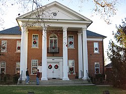
Montross courthouse.jpg
Westmoreland County Courthouse in Montross
Westmoreland Seal.jpg
Map of Virginia highlighting Westmoreland County.svg
Location within the U.S. state of Virginia
Virginia in United States.svg
Virginia's location within the U.S.
Coordinates: 38°07′N76°48′W / 38.11°N 76.8°W / 38.11; -76.8
CountryFlag of the United States.svg United States
StateFlag of Virginia.svg  Virginia
Founded1653
Named for Westmorland
Seat Montross
Largest town Colonial Beach
Area
  Total253 sq mi (660 km2)
  Land229 sq mi (590 km2)
  Water24 sq mi (60 km2)  9.3%
Population
 (2020)
  Total18,477
  Density73/sq mi (28/km2)
Time zone UTC−5 (Eastern)
  Summer (DST) UTC−4 (EDT)
Congressional district 1st
Website www.westmoreland-county.org

Westmoreland County is a county located in the Northern Neck of the Commonwealth of Virginia. As of the 2020 census, the population sits at 18,477. [1] Its county seat is Montross. [2]

Contents

History

Nomini Hall, the Carter family plantation in Westmoreland County, was built in 1730 on land purchased from heirs of Nicholas Spencer by Robert "King" Carter Nomini Hall Westmoreland County Virginia.jpg
Nomini Hall, the Carter family plantation in Westmoreland County, was built in 1730 on land purchased from heirs of Nicholas Spencer by Robert "King" Carter

As originally established by the Virginia colony's House of Burgesses, this area was separated from Northumberland County in 1653 and named for the English county of Westmorland; both counties are coastal. [3] The territory of Westmoreland County encompassed much of what later became the various counties and cities of Northern Virginia, including the city of Alexandria, Arlington County, Fairfax County, and Prince William County. These areas comprised part of Westmoreland until the formation of Stafford County in 1664.

Westmoreland County on Northern Neck was the birthplace of George Washington, who later became the first President of the United States (born at the former settlement of Bridges Creek, Virginia); [4] of James Monroe, the fifth President; and of Robert E. Lee, general and commander of the Confederate armies during the American Civil War of 1861–1865.

Colonel Nicholas Spencer (1633-1689) resided in this county. He patented the land at Mount Vernon in 1674 with his friend Lt. Col. John Washington, ancestor of George Washington. Spencer, who served as President of the Council and acting Governor (in office: 1683–1684) of the Colony of Virginia, was the cousin of, and agent for, the Barons Colepeper, proprietors of the Northern Neck. Spencer lived at his plantation, Nomini, which his descendants later sold to Robert Carter I (1662/63 – 1732) .

Robert Carter's grandson, Robert Carter III, is known for voluntarily freeing almost 500 slaves from Nomini Hall, beginning in 1791. He also provided for their settlement on land that he bought for them in Ohio Country.[ citation needed ] This manumission was the largest known release of slaves in North America prior to the American Civil War and involved the largest number ever manumitted by an individual in the U.S. [5]

Geography

Rural Westmoreland County Westmoreland County water tower.jpg
Rural Westmoreland County

According to the U.S. Census Bureau, the county has a total area of 253 square miles (660 km2), of which 229 square miles (590 km2) is land and 24 square miles (62 km2) (9.3%) is water. [6] Located on the Northern Neck, the county is within the Northern Neck George Washington Birthplace AVA winemaking appellation.

Adjacent counties

National protected areas

Demographics

Historical population
CensusPop.Note
1820 6,901
1830 8,39621.7%
1840 8,019−4.5%
1850 8,0800.8%
1860 8,2822.5%
1870 7,682−7.2%
1880 8,84615.2%
1890 8,399−5.1%
1900 9,24310.0%
1910 9,3130.8%
1920 10,24010.0%
1930 8,497−17.0%
1940 9,51211.9%
1950 10,1486.7%
1960 11,0428.8%
1970 12,14210.0%
1980 14,04115.6%
1990 15,48010.2%
2000 16,7188.0%
2010 17,4544.4%
2020 18,4775.9%
U.S. Decennial Census [7]
1790-1960 [8] 1900-1990 [9]
1990-2000 [10] 2010 [11] 2020 [12]

2020 census

Westmoreland County, Virginia - Demographic Profile
(NH = Non-Hispanic)
Race / EthnicityPop 2010 [11] Pop 2020 [12] % 2010% 2020
White alone (NH)11,08711,75863.52%63.64%
Black or African American alone (NH)4,8554,47027.82%24.19%
Native American or Alaska Native alone (NH)64670.37%0.36%
Asian alone (NH)911460.52%0.79%
Pacific Islander alone (NH)3110.02%0.06%
Some Other Race alone (NH)14680.08%0.37%
Mixed Race/Multi-Racial (NH)3389081.94%4.91%
Hispanic or Latino (any race)1,0021,0495.74%5.68%
Total17,45418,477100.00%100.00%

Note: the US Census treats Hispanic/Latino as an ethnic category. This table excludes Latinos from the racial categories and assigns them to a separate category. Hispanics/Latinos can be of any race.

2000 Census

At the 2000 census, [13] there were 16,718 people, 6,846 households and 4,689 families residing in the county. The population density was 73/sq mi (28/km2). There were 9,286 housing units at an average density of 40/sq mi (15/km2). The racial makeup of the county was 65.41% White, 30.89% Black or African American, 0.28% Native American, 0.36% Asian, 0.01% Pacific Islander, 1.75% from other races, and 1.29% from two or more races. 3.46% of the population were Hispanic or Latino of any race.

There were 6,846 households, of which 25.70% had children under the age of 18 living with them, 50.70% were married couples living together, 13.50% had a female householder with no husband present, and 31.50% were non-families. 26.90% of all households were made up of individuals, and 13.60% had someone living alone who was 65 years of age or older. The average household size was 2.43 and the average family size was 2.91.

23.00% of the population were under the age of 18, 6.30% from 18 to 24, 23.90% from 25 to 44, 27.80% from 45 to 64, and 19.00% who were 65 years of age or older. The median age was 43 years. For every 100 females, there were 92.30 males. For every 100 females age 18 and over, there were 88.90 males.

The median household income was $35,797 and the median family income was $41,357. Males had a median income of $31,333 and females $22,221. The per capita income was $19,473. About 11.20% of families and 14.70% of the population were below the poverty line, including 21.10% of those under age 18 and 12.50% of those age 65 or over.
Economy

The county's economy is largely based on agriculture. Tourism is another significant economic driver, related to historical sites such as George Washington Birthplace National Monument and Robert E. Lee's birthplace, Stratford Hall Plantation, and the Westmoreland County Museum as well as gambling activities available in Colonial Beach. The county is also an extended exurb of Washington, D.C.

Northern Neck Coca-Cola Bottling Inc. (makers of Northern Neck Ginger Ale) and the weekly Westmoreland News are located in Montross.

Notable people

George Washington Birthplace National Monument Geo Washington birthplace.jpg
George Washington Birthplace National Monument
View of the main facade of Stratford Hall, the ancestral home of the Lee family of Westmoreland County Stratford Hall .entrance Westmoreland Virginia.jpg
View of the main facade of Stratford Hall, the ancestral home of the Lee family of Westmoreland County

Communities

Towns

Politics

Westmoreland County is a notable bellwether for U.S. presidential politics, having voted for the winner in every election since 1928 except 1948, 1960, and 2020.

United States presidential election results for Westmoreland County, Virginia [14]
Year Republican Democratic Third party
No.%No.%No.%
2020 5,31853.54%4,50145.31%1141.15%
2016 4,44851.88%3,83644.74%2903.38%
2012 3,73145.95%4,29552.89%941.16%
2008 3,71944.40%4,57754.64%810.97%
2004 3,43350.13%3,37049.21%450.66%
2000 2,93248.66%2,92248.49%1722.85%
1996 2,33340.31%2,94950.95%5068.74%
1992 2,55441.04%2,75844.32%91114.64%
1988 2,97455.38%2,31143.04%851.58%
1984 3,21956.84%2,36341.73%811.43%
1980 2,51050.31%2,27145.52%2084.17%
1976 1,90941.79%2,35551.55%3046.65%
1972 2,33166.00%1,11331.51%882.49%
1968 1,40239.99%1,15632.97%94827.04%
1964 1,18147.26%1,31252.50%60.24%
1960 1,17653.00%1,03446.60%90.41%
1956 1,03354.45%69536.64%1698.91%
1952 1,11759.51%75440.17%60.32%
1948 56844.51%50339.42%20516.07%
1944 53239.58%80860.12%40.30%
1940 35729.68%84570.24%10.08%
1936 29625.36%87174.64%00.00%
1932 21224.74%64174.80%40.47%
1928 55458.50%39341.50%00.00%
1924 15723.97%48473.89%142.14%
1920 13325.09%39674.72%10.19%
1916 12627.10%33872.69%10.22%
1912 6915.16%34174.95%459.89%

See also

Related Research Articles

<span class="mw-page-title-main">Frederick County, Virginia</span> County in Virginia, United States

Frederick County is located in the Commonwealth of Virginia. As of the 2020 census, the population was 91,419. Its county seat is Winchester. The county was formed in 1743 by the splitting of Orange County. It is Virginia's northernmost county. Frederick County is included in the Winchester, VA-WV Metropolitan Statistical Area, which is also included in the Washington-Baltimore-Northern Virginia, DC-MD-VA-WV-PA Combined Statistical Area.

<span class="mw-page-title-main">Macon County, Alabama</span> County in Alabama, United States

Macon County is a county located in the east central part of the U.S. state of Alabama. As of the 2020 census, the population was 19,532. Its county seat is Tuskegee. Its name is in honor of Nathaniel Macon, a member of the United States Senate from North Carolina.

<span class="mw-page-title-main">Rockbridge County, Virginia</span> County in Virginia, United States

Rockbridge County is a county in the Shenandoah Valley on the western edge of the Commonwealth of Virginia. As of the 2020 census, the population was 22,650. Its county seat is the city of Lexington. Rockbridge County completely surrounds the independent cities of Buena Vista and Lexington. The Bureau of Economic Analysis combines the independent cities of Buena Vista and Lexington with Rockbridge County for statistical purposes.

<span class="mw-page-title-main">Richmond County, Virginia</span> County in Virginia, United States

Richmond County is a county located on the Northern Neck in the U.S. state of Virginia. As of the 2020 census, the population sits at 8,923. Its county seat is Warsaw. The rural county should not be confused with the large city and state capital Richmond, Virginia. It was formed in 1692 when the first Rappahannock County was divided to form Richmond County and Essex County.

<span class="mw-page-title-main">Northumberland County, Virginia</span> County in Virginia, United States

Northumberland County is a county located in the Commonwealth of Virginia. At the 2020 census, the population was 11,839. Its county seat is Heathsville. The county is located on the Northern Neck and is part of the Northern Neck George Washington Birthplace AVA winemaking appellation.

<span class="mw-page-title-main">Lancaster County, Virginia</span> County in Virginia, United States

Lancaster County is a county located on the Northern Neck in the Commonwealth of Virginia. As of the 2020 census, the population sits at 10,919. Its county seat is Lancaster.

<span class="mw-page-title-main">King George County, Virginia</span> County in Virginia, United States

King George County is a county located in the Commonwealth of Virginia. As of the 2020 census, the population sits at 26,723. Its county seat is the town of King George.

<span class="mw-page-title-main">Henry County, Virginia</span> County in Virginia, United States

Henry County is a county located in the U.S. state of Virginia. As of the 2020 census, the population was 50,948. The county seat is usually identified as Martinsville; however, the administration building, county courthouse, and Henry County Sheriff's Office are located on Kings Mountain Road in Collinsville.The Henry County Adult Detention Center is located on DuPont Road in Martinsville.

<span class="mw-page-title-main">Essex County, Virginia</span> County in Virginia, United States

Essex County is a county located in the Middle Peninsula in the U.S. state of Virginia; the peninsula is bordered by the Rappahannock River on the north and King and Queen County on the south. As of the 2020 census, the population was 10,599. Its county seat is Tappahannock.

<span class="mw-page-title-main">Dinwiddie County, Virginia</span> County in Virginia, United States

Dinwiddie County is a county located in the Commonwealth of Virginia. As of the 2020 census, the population was 27,947. Its county seat is Dinwiddie.

<span class="mw-page-title-main">Charles City County, Virginia</span> County in Virginia, United States

Charles City County is a county located in the U.S. commonwealth of Virginia. The county is situated southeast of Richmond and west of Jamestown. It is bounded on the south by the James River and on the east by the Chickahominy River.

<span class="mw-page-title-main">Appomattox County, Virginia</span> County in Virginia, United States

Appomattox County is a United States county located in the Piedmont region and near the center of the Commonwealth of Virginia. The county is part of the Lynchburg, VA Metropolitan Statistical Area, and its county seat is the town of Appomattox.

<span class="mw-page-title-main">Chantilly, Virginia</span> CDP in Virginia, United States

Chantilly is a census-designated place (CDP) in western Fairfax County, Virginia. The population was 24,301 as of the 2020 census. Chantilly is named after an early-19th-century mansion and farm, which in turn took the name of an 18th-century plantation that was located in Westmoreland County, Virginia. The name "Chantilly" originated in France with the Château de Chantilly, about 28 miles north of Paris.

<span class="mw-page-title-main">Great Falls, Virginia</span> Census-designated place in Virginia, United States

Great Falls is a census-designated place in Fairfax County, Virginia, United States. The population at the 2020 census was 15,953.

<span class="mw-page-title-main">Warsaw, Virginia</span> Town in Virginia, United States

Warsaw is an incorporated town in and the county seat of Richmond County, Virginia, United States. The population was 1,637 at the 2020 census and is estimated to be 2,281 as of 2022.

<span class="mw-page-title-main">Colonial Beach, Virginia</span> Town in Virginia, United States

Colonial Beach, Virginia (CBVA) is a river and beach town located in the northwestern part of Westmoreland County on Virginia's Northern Neck peninsula. It is bounded by the Potomac River, Monroe Bay and Monroe Creek. It is located 65 mi (105 km) from Washington, D.C.; 70 mi (110 km) from the state capital of Richmond; and 35 nautical miles from the Chesapeake Bay.

<span class="mw-page-title-main">Montross, Virginia</span> Town in Virginia, United States

Montross is a town in Westmoreland County, Virginia, United States. The population was 553 at the 2020 census. It is the county seat of Westmoreland County. Located in the historic Northern Neck of Virginia, Montross is near the George Washington Birthplace National Monument and the Stratford Hall Plantation. The town's slogan is return to the village.

<span class="mw-page-title-main">Northern Neck</span> Region in Virginia, United States

The Northern Neck is the northernmost of three peninsulas on the western shore of the Chesapeake Bay in the Commonwealth of Virginia. The Potomac River forms the northern boundary of the peninsula; the Rappahannock River demarcates it on the south. The land between these rivers was formed into Northumberland County in 1648, prior to the creation of Westmoreland County and Lancaster County. The Northern Neck encompasses the following Virginia counties: Lancaster, Northumberland, Richmond, King George and Westmoreland; it had a total population of 50,158 as of the 2020 census.

<span class="mw-page-title-main">Robert Carter III</span> American planter and politician (1728–1804)

Robert Carter III was an American planter and politician from the Northern Neck of Virginia. During the colonial period, he sat on the Virginia Governor's Council for roughly two decades. After the American Revolutionary War saw the Thirteen Colonies gain independence from the British Empire as the United States, Carter, influenced by his belief in Baptism, began the largest manumission in the history of the United States prior to the American Civil War.

<span class="mw-page-title-main">Heathsville, Virginia</span> Census-designated place in Virginia, United States

Heathsville is a census-designated place (CDP) in and the county seat of Northumberland County, Virginia, United States. Heathsville is in the easternmost county of the Northern Neck of Virginia, which was the birthplace of three of the first five Presidents of the United States - George Washington, James Madison, and James Monroe. It is the county seat of Northumberland County, and has housed four county courthouses since the first was built in 1663.

References

  1. "Westmoreland County, Virginia". United States Census Bureau . Retrieved January 30, 2022.
  2. "Find a County". National Association of Counties. Retrieved June 7, 2011.
  3. "Virginia County Names - A History". September 21, 2013.
  4. Marquis, A.N. Company. Who's Who In America, vol. 1:Historical Volume (1607-1896), revised ed., Marquis, A.N. Company., 1967.
  5. Levy, Andrew (2005). The First Emancipator: The Forgotten Story of Robert Carter, the Founding Father Who Freed His Slaves. Random House. p. 147. ISBN   978-1-58836-469-2. he undertook the largest private emancipation in American history
  6. "US Gazetteer files: 2010, 2000, and 1990". United States Census Bureau. February 12, 2011. Retrieved April 23, 2011.
  7. "Census of Population and Housing from 1790-2000". US Census Bureau . Retrieved January 24, 2022.
  8. "Historical Census Browser". University of Virginia Library. Retrieved January 5, 2014.
  9. "Population of Counties by Decennial Census: 1900 to 1990". United States Census Bureau. Retrieved January 5, 2014.
  10. "Census 2000 PHC-T-4. Ranking Tables for Counties: 1990 and 2000" (PDF). United States Census Bureau. Archived (PDF) from the original on October 9, 2022. Retrieved January 5, 2014.
  11. 1 2 "P2 HISPANIC OR LATINO, AND NOT HISPANIC OR LATINO BY RACE - 2010: DEC Redistricting Data (PL 94-171) - Westmoreland County, Virginia". United States Census Bureau .
  12. 1 2 "P2 HISPANIC OR LATINO, AND NOT HISPANIC OR LATINO BY RACE - 2020: DEC Redistricting Data (PL 94-171) - Westmoreland County, Virginia". United States Census Bureau .
  13. "U.S. Census website". United States Census Bureau . Retrieved May 14, 2011.
  14. Leip, David. "Dave Leip's Atlas of U.S. Presidential Elections". uselectionatlas.org.

38°07′N76°48′W / 38.11°N 76.80°W / 38.11; -76.80