Culpeper County, Virginia

Last updated

Culpeper County
Culpeper County Courthouse, Culpeper (Culpeper County, Virginia).jpg
Culpeper County Courthouse
Flag of the Culpeper Minutemen.svg
Culpeper Seal.png
Map of Virginia highlighting Culpeper County.svg
Location within the U.S. state of Virginia
Virginia in United States.svg
Virginia's location within the U.S.
Coordinates: 38°29′N77°58′W / 38.49°N 77.96°W / 38.49; -77.96
CountryFlag of the United States.svg United States
StateFlag of Virginia.svg  Virginia
Founded1749
Named for Thomas Colepeper
Seat Culpeper
Largest townCulpeper
Area
  Total383 sq mi (990 km2)
  Land379 sq mi (980 km2)
  Water3.3 sq mi (9 km2)  0.9%
Population
 (2020)
  Total52,552
  Density140/sq mi (53/km2)
Time zone UTC−5 (Eastern)
  Summer (DST) UTC−4 (EDT)
Congressional district 7th
Website www.culpepercounty.gov

Culpeper County is a county located along the borderlands of the northern and central region of the Commonwealth of Virginia. As of the 2020 United States Census, the population was 52,552. [1] Its county seat and only incorporated community is Culpeper. [2]

Contents

Culpeper County is included in the Washington–Baltimore–Arlington, DC–MD–VA–WV–PA Combined Statistical Area.

History

At the time of European encounter, the inhabitants of future Culpeper County were a Siouan-speaking sub-group of the Manahoac tribe called the Tegninateo. [3] Culpeper County was established in 1749, with territory partitioned from Orange County. The county is named for Thomas Colepeper, 2nd Baron Colepeper, colonial governor of Virginia from 1677 to 1683.

In May 1749, the first Culpeper Court convened in the home of Robert Tureman, near the present location of the Town of Culpeper. In July 1749, Tureman commissioned 17-year-old George Washington as the first County surveyor. [4] One of his first duties was to lay out the county's courthouse complex, which included the courthouse, jail, stocks, gallows and accessory buildings. By 1752 the complex stood at the present northeast corner of Davis and Main Streets. The courthouse village was named Town of Fairfax for Thomas Fairfax, 6th Lord Fairfax of Cameron (1693–1781). [5]

Cornfields east of Culpeper Cornfields east of Culpeper, VA IMG 4315.JPG
Cornfields east of Culpeper

During the Virginia convention held in May 1775, the colony was divided into sixteen districts. Each district had instructions to raise a battalion of men "to march at a minute's notice." Culpeper, Orange and Fauquier, forming one district, raised 350 men in "Clayton's old field" on the Catalpa estate; they were called the Culpeper Minute Men. In December, the Minute Men, marching under their flag depicting a rattlesnake and inscribed with the words "Liberty or Death" and "Don't Tread on Me", took part in the Battle of Great Bridge, the first Revolutionary battle on Virginia soil. The Culpeper Minute Men reorganized in 1860 in response to the impending Civil War and became part of 13th Infantry's Company B, fighting against the US Government forces. The Culpeper Minutemen were again organized for World War I, and joined the 116th Infantry.

In 1833, based on the county's growing population and the need of those in the northwestern area for easier access to a county seat, the upper 267 square miles (690 km2) of Culpeper County was partitioned off to create Rappahannock County, Virginia, which was founded by an act of the Virginia General Assembly.

During the Civil War the Battle of Cedar Mountain took place on 9 August 1862, and the Battle of Brandy Station occurred on 9 June 1863, in Culpeper County.

Culpeper was the boyhood home of Civil War General A. P. Hill, who fought against Union forces.

The negative impact of the Massive Resistance campaign against school integration led to the statewide election of a pro-desegregation governor. By the middle of the 1970s, [6] Culpeper was the last county in Virginia to desegregate its public schools. In 2018 Culpeper County Public Schools [7] has six elementary, two middle schools and two high schools. In 1935 the Rotary Club of Culpeper began a college loan fund, which in 1966 became a four-year scholarship based on academic achievement. The group also provides a Technical School scholarship based on academic achievement. [8]

Culpeper County is home to Commonwealth Park, site for many world-class equestrian events. It was here that actor Christopher Reeve suffered his 1995 accident during a competition.

The town of Culpeper was rated #10 by Norman Crampton, author of "The 100 Best Small Towns in America," in February, 1993.

In April 2016, the county Board of Supervisors denied a routine request from the Islamic Center of Culpeper for a pump and haul permit to serve their envisioned mosque. This resulted in a lawsuit by the US Department of Justice in December. [9]

Economy

Culpeper County has a civilian workforce of 24,313. [10] 30% of residents live and work within the county while 70% of workers commute out of the locality. The most residents are commuting to Fairfax or Fauquier counties. In comparison, the equivalent of 45% are in-commuters. The most in-commuters are coming from Orange County. [11]

The Top 10 non-governmental Culpeper employers as of March 2023: [11]

  1. Culpeper Memorial Hospital
  2. Walmart
  3. Masco (Cabinetworks)
  4. S.W.I.F.T.
  5. Bingham and Taylor Corporation
  6. Continental Automotive
  7. Cintas Corporation
  8. Virginia Baptist Homes (The Culpeper Senior Living)
  9. Communications Corporation of America
  10. LaborReady Mid-Atlantic

Geography

US 15/US 29 near Culpeper in Culpeper County 2019-09-02 12 07 55 View north along U.S. Route 15 and U.S. Route 29 (James Madison Highway) from the overpass for U.S. Route 522 and Virginia State Route 3 (Germanna Highway) just southeast of Culpeper in Culpeper County, Virginia.jpg
US 15/US 29 near Culpeper in Culpeper County
Charlottesville to Merrifield.svg
Albemarle
Louisa
Greene
Page
Madison
Rappahannock
Red pog.svg
Charlottesville
Fauquier
Red pog.svg
Manassas
Red pog.svg
Manassas Park
Prince William
Spotsylvania
Stafford
Red pog.svg
Fredericksburg
Culpeper
Orange
Caroline
King George
Culpeper County, Virginia (Charlottesville to Merrifield)

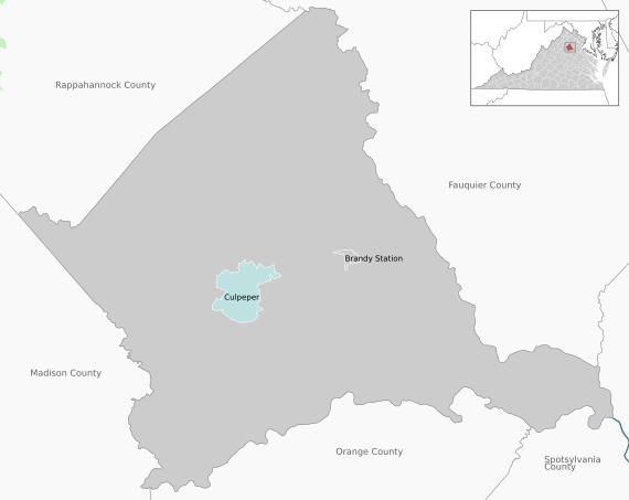
The northeast border of Culpeper County is defined by the Rappahannock River which flows east-southeastward along its border, while the south border of the county is similarly defined by the meanders of the Rapidan River. The Hazel River flows eastward through the county, discharging into the Rappahannock on the county's east border, while the Thornton River also flows eastward through the county, discharging into the Hazel in the north part of the county. The county is in the foothills of the Blue Ridge Mountains, which are quickly accessed beginning with Old Rag Mountain and the Skyline Drive just up Route 522. [12] The rolling hills generally slope to the south and east, with its highest point near its west corner at 705 ft (215 m) ASL. [13] The county has a total area of 383 square miles (990 km2), of which 379 square miles (980 km2) is land and 3.3 square miles (8.5 km2) (0.9%) is water. [14]

Major highways

Adjacent counties

Protected areas

  • Brandy Station Battlefield Park
  • Mountain Run Lake Park

[12]

Lakes

  • Balds Run Reservoir
  • Brandy Rock Farm Lake
  • Caynor Lake
  • Lake Culpeper
  • Merrimac/Mountain Run Lake

[12]

Government

Board of Supervisors

Constitutional Offices

State representatives

Culpeper County is represented by Republicans Bryce E. Reeves, Emmett W. Hanger Jr., and Jill Holtzman Vogel in the Virginia Senate, Republicans Michael J. Webert and Nicholas J. (Nick) Freitas in the Virginia House of Delegates, and Democrat Abigail Spanberger in the U.S. House of Representatives.

Culpeper County has been a Republican precinct for several decades. In only one national election since 1948 has the county selected the Democratic Party candidate (as of 2020).

United States presidential election results for Culpeper County, Virginia [27]
Year Republican Democratic Third party
No.%No.%No.%
2020 16,01259.05%10,61739.15%4871.80%
2016 13,34960.08%7,75934.92%1,1105.00%
2012 11,58057.30%8,28540.99%3461.71%
2008 10,71154.26%8,80244.59%2281.15%
2004 10,02664.25%5,47635.09%1030.66%
2000 7,44060.76%4,36435.64%4403.59%
1996 5,68853.90%3,90737.02%9589.08%
1992 5,22649.93%3,44432.91%1,79617.16%
1988 5,89668.57%2,55529.71%1481.72%
1984 5,59670.60%2,25528.45%750.95%
1980 4,31259.43%2,51934.72%4245.84%
1976 3,65954.64%2,89243.19%1452.17%
1972 3,70772.80%1,31625.84%691.36%
1968 2,22947.49%1,23926.40%1,22626.12%
1964 1,77548.43%1,88651.46%40.11%
1960 1,63054.86%1,33244.83%90.30%
1956 1,50256.44%96636.30%1937.25%
1952 1,50760.33%98739.51%40.16%
1948 68240.14%80447.32%21312.54%
1944 75042.30%1,02257.64%10.06%
1940 57932.27%1,20867.34%70.39%
1936 55130.21%1,26669.41%70.38%
1932 41723.40%1,34975.70%160.90%
1928 75347.39%83652.61%00.00%
1924 19017.15%87679.06%423.79%
1920 33025.27%97374.50%30.23%
1916 18417.73%84981.79%50.48%
1912 10811.80%75282.19%556.01%

Procurement

Recent media investigations regarding law enforcement procurement of military equipment through the "1033" program offered by the Defense Logistics Agency identified Culpeper County as having received, as donations, a "Mine Resistant Vehicle" in 2013 worth $412,000 and 20 night-vision optics worth an additional $136,000.00. [28]

Demographics

Historical population
CensusPop.Note
1790 22,105
1800 18,100−18.1%
1810 18,9674.8%
1820 20,94410.4%
1830 24,02714.7%
1840 11,393−52.6%
1850 12,2827.8%
1860 12,063−1.8%
1870 12,2271.4%
1880 13,4089.7%
1890 13,233−1.3%
1900 14,1236.7%
1910 13,472−4.6%
1920 13,292−1.3%
1930 13,3060.1%
1940 13,3650.4%
1950 13,242−0.9%
1960 15,08813.9%
1970 18,21820.7%
1980 22,62024.2%
1990 27,79122.9%
2000 34,26223.3%
2010 46,68936.3%
2020 52,55212.6%
U.S. Decennial Census [29]
1790–1960 [30] 1900–1990 [31]
1990–2000 [32] 2010 [33] 2020 [34]

2020 census

Culpeper County, Virginia – Racial and ethnic composition
Note: the US Census treats Hispanic/Latino as an ethnic category. This table excludes Latinos from the racial categories and assigns them to a separate category. Hispanics/Latinos may be of any race.
Race / Ethnicity (NH = Non-Hispanic)Pop 2010 [33] Pop 2020 [34] % 2010% 2020
White alone (NH)33,48234,84071.71%66.30%
Black or African American alone (NH)7,2126,45315.45%12.28%
Native American or Alaska Native alone (NH)1291100.28%0.21%
Asian alone (NH)5937671.27%1.46%
Pacific Islander alone (NH)12200.03%0.04%
Some Other Race alone (NH)1002330.21%0.44%
Mixed Race or Multi-Racial (NH)1,0042,6202.15%4.99%
Hispanic or Latino (any race)4,1577,5098.90%14.29%
Total46,68952,552100.00%100.00%

2000 census

As of the 2000 United States Census, there were 34,262 people, 12,141 households, and 9,045 families in the county. The population density was 90.4 people per square mile (34.9 people/km2). There were 12,871 housing units at an average density of 34.0 units per square mile (13.1 units/km2). The racial makeup of the county was 68.27% White, 28.15% Black or African American, 0.33% Native American, 0.66% Asian, 0.01% Pacific Islander, 1.15% from other races, and 1.43% from two or more races. 2.50% of the population were Hispanic or Latino of any race.

There were 12,141 households, out of which 35.00% had children under the age of 18 living with them, 58.50% were married couples living together, 11.30% had a female householder with no husband present, and 25.50% were non-families. 20.60% of all households were made up of individuals, and 7.90% had someone living alone who was 65 years of age or older. The average household size was 2.68 and the average family size was 3.08.

The county population contained 25.70% under the age of 18, 8.10% from 18 to 24, 31.10% from 25 to 44, 23.30% from 45 to 64, and 11.90% who were 65 years of age or older. The median age was 36 years. For every 100 females, there were 103.30 males. For every 100 females age 18 and over, there were 103.20 males.

The median income for a household in the county was $45,290, and the median income for a family was $51,475. Males had a median income of $36,621 versus $25,985 for females. The per capita income for the county was $20,162. About 27.00% of families and 29.20% of the population were below the poverty line, including 38.30% of those under age 18 and 28.60% of those age 65 or over.

Education

Culpeper County Public Schools

Elementary schools

  • A.G. Richardson Elementary
  • Culpeper Christian
  • Emerald Hill Elementary
  • Epiphany Catholic School
  • Farmington Elementary
  • Pearl Sample Elementary
  • Sycamore Park Elementary
  • Yowell Elementary

Middle schools

High schools

Communities

Municipalities in Culpeper County.svg

Town

Unincorporated communities

[12]

U.S. Route 211 as it passes through Culpeper County US Route 211 in Culpeper County.jpg
U.S. Route 211 as it passes through Culpeper County

Notable people

See also

Related Research Articles

<span class="mw-page-title-main">Frederick County, Virginia</span> County in Virginia, United States

Frederick County is located in the Commonwealth of Virginia. As of the 2020 census, the population was 91,419. Its county seat is Winchester. The county was formed in 1743 by the splitting of Orange County. It is Virginia's northernmost county. Frederick County is included in the Winchester, VA-WV Metropolitan Statistical Area, which is also included in the Washington-Baltimore-Northern Virginia, DC-MD-VA-WV-PA Combined Statistical Area.

<span class="mw-page-title-main">Westmoreland County, Virginia</span> County in Virginia, United States

Westmoreland County is a county located in the Northern Neck of the Commonwealth of Virginia. As of the 2020 census, the population sits at 18,477. Its county seat is Montross.

<span class="mw-page-title-main">Warren County, Virginia</span> County in Virginia, United States

Warren County is a U.S. county located in the Commonwealth of Virginia. The 2020 census places Warren County within the Washington-Arlington-Alexandria, DC-VA-MD-WV Metropolitan Statistical Area with a population of 40,727. The county was established in 1836. The county seat is Front Royal.

<span class="mw-page-title-main">Spotsylvania County, Virginia</span> County in Virginia, United States

Spotsylvania County is a county in the U.S. state of Virginia. As of the July 2021 estimate, the population was 145,300. Its county seat is Spotsylvania Courthouse.

<span class="mw-page-title-main">Richmond County, Virginia</span> County in Virginia, United States

Richmond County is a county located on the Northern Neck in the U.S. state of Virginia. As of the 2020 census, the population sits at 8,923. Its county seat is Warsaw. The rural county should not be confused with the large city and state capital Richmond, Virginia. It was formed in 1692 when the first Rappahannock County was divided to form Richmond County and Essex County.

<span class="mw-page-title-main">Rappahannock County, Virginia</span> County in Virginia, United States

Rappahannock County is a county located in the northern Piedmont region of the Commonwealth of Virginia, US, adjacent to Shenandoah National Park. As of the 2020 Census, the population was 7,348. Its county seat is Washington. The name "Rappahannock" comes from the Algonquian word lappihanne, meaning "river of quick, rising water" or "where the tide ebbs and flows." The county is included in the Washington-Arlington-Alexandria, DC-VA-MD-WV Metropolitan Statistical Area.

<span class="mw-page-title-main">Prince William County, Virginia</span> County in Virginia, United States

Prince William County is located on the Potomac River in the U.S. state of Virginia. As of the 2020 census, the population sits at 482,204, making it Virginia's second-most populous county. Its county seat is the independent city of Manassas.

<span class="mw-page-title-main">Middlesex County, Virginia</span> County in Virginia, United States

Middlesex County is a county located on the Middle Peninsula in the U.S. state of Virginia. As of the 2020 census, the population was 10,625. Its county seat is Saluda.

<span class="mw-page-title-main">Madison County, Virginia</span> County in Virginia, United States

Madison County is a county located in the Commonwealth of Virginia. As of the 2020 census, the population was 13,837. Its county seat is Madison.

<span class="mw-page-title-main">Fauquier County, Virginia</span> County in Virginia, United States

Fauquier County is a county in the Commonwealth of Virginia. As of the 2020 census, the population was 72,972. The county seat is Warrenton.

<span class="mw-page-title-main">Essex County, Virginia</span> County in Virginia, United States

Essex County is a county located in the Middle Peninsula in the U.S. state of Virginia; the peninsula is bordered by the Rappahannock River on the north and King and Queen County on the south. As of the 2020 census, the population was 10,599. Its county seat is Tappahannock.

<span class="mw-page-title-main">Clarke County, Virginia</span> County in Virginia, United States

Clarke County is a county in the Commonwealth of Virginia. As of the 2020 census, the population was 14,783. Its county seat is Berryville. Clarke County is included in the Washington-Arlington-Alexandria, DC-VA-MD-WV Metropolitan Statistical Area.

<span class="mw-page-title-main">Culpeper, Virginia</span> Town in Virginia, United States

Culpeper is an incorporated town in Culpeper County, Virginia, United States. The population was 20,062 at the 2020 census, up from 16,379 at the 2010 census. It is the county seat of Culpeper County.

<span class="mw-page-title-main">Great Falls, Virginia</span> Census-designated place in Virginia, United States

Great Falls is a census-designated place in Fairfax County, Virginia, United States. The population at the 2020 census was 15,953.

<span class="mw-page-title-main">Remington, Virginia</span> Town in Virginia, United States

Remington is a small incorporated town in Fauquier County, Virginia, United States. The population was 598 at the 2010 census. It is near the highways, U.S. Route 15, U.S. Route 17, U.S. Route 29, and Virginia State Route 28. Remington is less than a mile northeast of the Culpeper County line.

<span class="mw-page-title-main">Warrenton, Virginia</span> Town in Virginia, United States

Warrenton is a town in Fauquier County, Virginia, of which it is the seat of government. The population was 10,057 as of the 2020 census, an increase from 9,611 at the 2010 census and 6,670 at the 2000 census. The estimated population in July 2021 was 10,109. It is at the junction of U.S. Route 15, U.S. Route 17, U.S. Route 29, and U.S. Route 211. The town is in the Piedmont region of Virginia just east of the Blue Ridge Mountains. The well-known Airlie Conference Center is 3 miles (5 km) north of Warrenton, and the historic Vint Hill Farms military facility is 9 miles (14 km) east. Fauquier Hospital is located in the town. Surrounded by Virginia wine and horse country, Warrenton is a popular destination outside Washington, D.C.

<span class="mw-page-title-main">Warsaw, Virginia</span> Town in Virginia, United States

Warsaw is an incorporated town in and the county seat of Richmond County, Virginia, United States. The population was 1,637 at the 2020 census and is estimated to be 2,281 as of 2022.

Bealeton is a census-designated place (CDP) in Fauquier County, Virginia, United States, at the intersection of U.S. Route 17 and State Route 28. The population was 4,435 at the 2010 census.

<span class="mw-page-title-main">Opal, Virginia</span> Census-designated place in Virginia, United States

Opal is an unincorporated community and census-designated place (CDP) in Fauquier County, Virginia, United States. It is on U.S. Highway 15/U.S. Route 17 and U.S. Route 29, at an elevation of 449 feet (137 m). The population as of the 2010 census was 691.

Jonathan Catlett Gibson, Jr. was a nineteenth-century Virginia lawyer, farmer and Confederate soldier who represented Fauquier County in the Virginia Constitutional Convention of 1868 and later Culpeper County in the Virginia House of Delegates.

References

  1. "2020 Population and Housing State Data". United States Census Bureau. August 12, 2021. Archived from the original on August 12, 2021. Retrieved October 26, 2021.
  2. "Find a County". National Association of Counties. Archived from the original on May 31, 2011. Retrieved June 7, 2011.
  3. Swanton, John R. (1952), The Indian Tribes of North America, Smithsonian Institution, pp. 61–62, ISBN   0-8063-1730-2, OCLC   52230544
  4. Abbott, W.W., editor. The Papers of George Washington: Colonial Series, Vol. 1 (University Press of Virginia: 1983) p. 9
  5. Culpeper County Comprehensive Plan, 2005 Archived October 24, 2007, at the Wayback Machine
  6. Encyclopedia Virginia: Desegregation in Public Schools, accessed March 2018.
  7. Culpeper County Public Schools official website, accessed March 2018.
  8. Rotary Club of Culpeper: Scholarships, accessed 2018.
  9. Washington Post (15 December 2016)
  10. "Estimated Labor Force Components, August 2021" (PDF). Virginia Employment Commission. VEC. Archived (PDF) from the original on October 9, 2022.
  11. 1 2 "Community Profile" (PDF). Virginia Works. VEC.
  12. 1 2 3 4 Culpeper County VA Google Maps (accessed 14 April 2019)
  13. ""Find an Altitude/Culpeper County VA" Google Maps (accessed 14 April 2019)". Archived from the original on May 21, 2019. Retrieved April 14, 2019.
  14. "US Gazetteer files: 2010, 2000, and 1990". US Census Bureau. February 12, 2011. Retrieved April 23, 2011.
  15. "Catalpa District". Culpeper County Virginia. Retrieved July 18, 2023.
  16. "Cedar Mountain District". Culpeper County Virginia. Retrieved July 18, 2023.
  17. "East Fairfax District". Culpeper County Virginia. Retrieved July 18, 2023.
  18. "Jefferson District". Culpeper County Virginia. Retrieved July 18, 2023.
  19. "Salem District". Culpeper County Virginia. Retrieved July 18, 2023.
  20. "Stevensburg District". Culpeper County Virginia. Retrieved July 18, 2023.
  21. "West Farifax District". Culpeper County Virginia. Retrieved July 18, 2023.
  22. "Circuit Court Contact Information". Culpeper County Virginia. Retrieved July 18, 2023.
  23. "Commissioner of the Revenue Contact Information". Culpeper County Virginia. Retrieved July 18, 2023.
  24. "Commonwealth Attorney Contact Information". Culpeper County Virginia. Retrieved July 18, 2023.
  25. "Culpeper County Sheriff's Office". culpepersheriff. Retrieved July 18, 2023.
  26. "Treasurer Contact Information". Culpeper County Virginia. Retrieved July 18, 2023.
  27. David Leip. "Dave Leip's Atlas of U.S. Presidential Elections". Uselectionatlas.org. Retrieved December 8, 2020.
  28. DHS 1033 Program Database http://www.freep.com/article/20140817/NEWS06/140726001
  29. "Census of Population and Housing from 1790-2000". US Census Bureau . Retrieved January 24, 2022.
  30. "Historical Census Browser". University of Virginia Library. Archived from the original on August 11, 2012. Retrieved January 1, 2014.
  31. "Population of Counties by Decennial Census: 1900 to 1990". US Census Bureau. Retrieved January 1, 2014.
  32. "Census 2000 PHC-T-4. Ranking Tables for Counties: 1990 and 2000" (PDF). US Census Bureau. Archived (PDF) from the original on October 9, 2022. Retrieved January 1, 2014.
  33. 1 2 "P2 Hispanic or Latino, and Not Hispanic or Latino by Race – 2010: DEC Redistricting Data (PL 94-171) - Culpeper County, Virginia". United States Census Bureau .
  34. 1 2 "P2 Hispanic or Latino, and Not Hispanic or Latino by Race – 2020: DEC Redistricting Data (PL 94-171) - Culpeper County, Virginia". United States Census Bureau .

38°29′N77°58′W / 38.49°N 77.96°W / 38.49; -77.96