Virginia, officially the Commonwealth of Virginia, is a state in the Southeastern and Mid-Atlantic regions of the United States between the Atlantic Coast and the Appalachian Mountains. The state's capital is Richmond and its most populous city is Virginia Beach. Its most populous subdivision is Fairfax County, part of Northern Virginia, where slightly over a third of Virginia's population of 8.7 million live.

Adeline Virginia Woolf was an English writer. She is considered one of the most important modernist 20th-century authors. She pioneered the use of stream of consciousness as a narrative device.

West Virginia is a landlocked state in the Southern and Mid-Atlantic regions of the United States. It is bordered by Pennsylvania and Maryland to the northeast, Virginia to the southeast, Kentucky to the southwest, and Ohio to the northwest. West Virginia is the 10th-smallest state by area and ranks as the 12th-least populous state, with a population of 1,793,716 residents. The capital and most populous city is Charleston with a population of 49,055.

Richmond is the capital city of the Commonwealth of Virginia in the United States. Incorporated in 1742, Richmond has been an independent city since 1871. The city's population in the 2020 census was 226,610, up from 204,214 in 2010, making it Virginia's fourth-most populous city. The Richmond metropolitan area, with over 1.3 million residents, is the Commonwealth's third-most populous.

Virginia Beach, officially the City of Virginia Beach, is the most populous city in the Commonwealth of Virginia in the United States. The population was 459,470 at the 2020 census. Located on the southeastern coast of Virginia, it is the sixth-most populous city in the Mid-Atlantic and the 42nd-most populous city in the U.S. Located on the Atlantic Ocean at the mouth of the Chesapeake Bay, Virginia Beach is a principal city in the Hampton Roads metropolitan area which has more than 1.8 million inhabitants and is the 37th-largest metropolitan area in the U.S.

Culpeper County is a county located along the borderlands of the northern and central region of the Commonwealth of Virginia. As of the 2020 United States Census, the population was 52,552. Its county seat and only incorporated community is Culpeper.

The Colony of Virginia was a British colonial settlement in North America from 1606 to 1776.

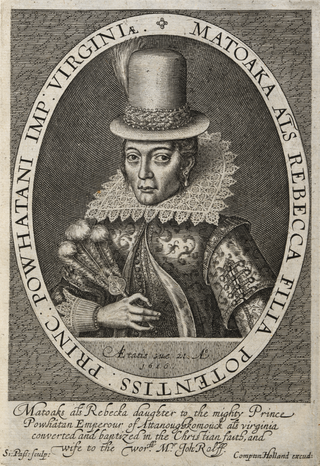
Pocahontas was a Native American woman belonging to the Powhatan people, notable for her association with the colonial settlement at Jamestown, Virginia. She was the daughter of Powhatan, the paramount chief of a network of tributary tribes in the Tsenacommacah, encompassing the Tidewater region of what is today the U.S. state of Virginia.

The Rappahannock River is a river in eastern Virginia, in the United States, approximately 195 miles (314 km) in length. It traverses the entire northern part of the state, from the Blue Ridge Mountains in the west where it rises, across the Piedmont to the Fall Line, and onward through the coastal plain to flow into the Chesapeake Bay, south of the Potomac River.
Richardville may refer to:
Most gold mining in Virginia was concentrated in the Virginia Gold-Pyrite belt in a line that runs northeast to southwest through the counties of Fairfax, Prince William, Stafford, Fauquier, Culpeper, Spotsylvania, Orange, Louisa, Fluvanna, Goochland, Cumberland, and Buckingham. Some gold was also mined in Halifax, Floyd, and Patrick counties.

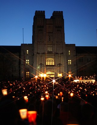
The Virginia Tech shooting was a spree shooting that occurred on Monday, April 16, 2007, comprising two attacks on the campus of the Virginia Polytechnic Institute and State University in Blacksburg, Virginia, United States. Seung-Hui Cho, an undergraduate student at the university, killed 32 people and wounded 17 others with two semi-automatic pistols before committing suicide. Six others were injured jumping out of windows to escape Cho.

The King Iron Bridge & Manufacturing Company was a late-19th-century bridge building company located in Cleveland, Ohio. It was founded by Zenas King (1818–1892) in 1858 and subsequently managed by his sons, James A. King and Harry W. King and then his grandson, Norman C. King, until the mid-1920s. Many of the bridges built by the company were used during America's expansion west in the late 19th century and early 20th century, and some of these bridges are still standing today.

Kentucky Route 526 is a state highway that provides a short rural connecting route between KY 185 and US 31W/US 68/KY 80 north of Bowling Green. Running through the north-central part of Warren County, the route is known locally as Mt. Olivet Road.
Richardsville is an unincorporated community in Jefferson County, in the U.S. state of Pennsylvania.
Richardsville may refer to:
Richardsville is an unincorporated community in Warren County, in the U.S. state of Kentucky.
Glenmore is an unincorporated community located in northern Warren County, Kentucky, United States. Glenmore is part of the Bowling Green Metropolitan Statistical Area.
Warren County Public Schools is a school division that serves students living in Warren County, Kentucky.
Dicktown is an American adult animated sitcom created and written by John Hodgman and David Rees for FXX. Hodgman and Rees also star, and serve as executive producers alongside Matt Thompson. The show's concept has been described as a mix of "a little Encyclopedia Brown, a little Scooby-Doo, and a lot of heart."


