Washington County is a county located in the southeastern part of the U.S. state of Missouri. As of the 2020 United States census, the population was 23,514. The county seat and largest city is Potosi. The county was officially organized on August 21, 1813, and was named in honor of George Washington, the first President of the United States.

Hillsboro is an unincorporated community in Sierra County, New Mexico, United States, located in the southwestern part of the state. It was founded in 1877, following the discovery of gold. The community was the county seat of Sierra County from 1884 until 1936, when Hot Springs became the county seat.

Hatcher Pass is a mountain pass through the southwest part of the Talkeetna Mountains, Alaska. It is named after Robert Hatcher, a prospector and miner. The nearest cities are Palmer and Wasilla approximately 12 miles (19 km) to the south, and Willow approximately 26 mi (42 km) to the west. The communities are at an elevation of approximately 250 ft (76 m) in the Mat-Su valley.

Palmer is a town just east of the Adelaide Hills region of South Australia along the Adelaide-Mannum Road, 70 kilometres east-north-east of the state capital, Adelaide and 15 km west-north-west of Mannum. It is located in the Mid Murray Council local government area.

Tukgahgo Mountain (TUG-a-ho) is a mountain in the Takshanuk Mountains in the U.S. state of Alaska with a peak elevation of 4,675 feet (1,425 m). It is located in Haines Borough, 3.5 miles (5.6 km) to the southwest of Chilkoot Lake and 16 miles (26 km) to the southwest of Skagway. Geological investigations of the veins in the mountain have revealed silver, gold, platinum, and palladium mineralization, derived from mid-Cretaceous events.
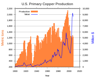
In the United States, copper mining has been a major industry since the rise of the northern Michigan copper district in the 1840s. In 2017, the US produced 1.27 million metric tonnes of copper, worth $8 billion, making it the world's fourth largest copper producer, after Chile, China, and Peru. Copper was produced from 23 mines in the US. Top copper producing states in 2014 were Arizona, Utah, New Mexico, Nevada, and Montana. Minor production also came from Idaho, and Missouri. As of 2014, the US had 45 million tonnes of known remaining reserves of copper, the fifth largest known copper reserves in the world, after Chile, Australia, Peru, and Mexico.

In the United States, gold mining has taken place continually since the discovery of gold at the Reed farm in North Carolina in 1799. The first documented occurrence of gold was in Virginia in 1782. Some minor gold production took place in North Carolina as early as 1793, but created no excitement. The discovery on the Reed farm in 1799 which was identified as gold in 1802 and subsequently mined marked the first commercial production.

Uranium mining in Colorado, United States, goes back to 1872, when pitchblende ore was taken from gold mines near Central City, Colorado. The Colorado uranium industry has seen booms and busts, but continues to this day. Not counting byproduct uranium from phosphate, Colorado is considered to have the third largest uranium reserves of any US state, behind Wyoming and New Mexico.
Gold mining in Alaska, a state of the United States, has been a major industry and impetus for exploration and settlement since a few years after the United States acquired the territory in 1867 from the Russian Empire. Russian explorers discovered placer gold in the Kenai River in 1848, but no gold was produced. Gold mining started in 1870 from placers southeast of Juneau, Alaska.

Bodie is a ghost town in Okanogan County, Washington, United States.

Paint Bank is an unincorporated community in northern Craig County, Virginia, United States. It is located at the intersection of State Route 18 and State Route 311 northwest of the town of New Castle, the county seat. The village is located between Potts Mountain and Peters Mountain. It is one of the westernmost communities of the Roanoke metropolitan area.
The South Pass greenstone belt is located within the Wyoming craton in the US. The region was the site of Wyoming's initial gold discovery in 1842.
The Devonian Old Port Formation is a mapped bedrock unit in Pennsylvania, USA. Details of the type section and of stratigraphic nomenclature for this unit as used by the U.S. Geological Survey are available on-line at the National Geologic Map Database. Current nomenclature usage by U.S. Geological Survey restricts the name Old Port Formation to Pennsylvania, but correlative units are present in adjacent states.
Fine Gold Creek, in Fine Gold Gulch, is a creek in a gulch in Madera County, California that is a river tributary of the San Joaquin River. It is approximately 18 miles (29 km) from its mouth on the San Joaquin through where it has two forks to its headwaters.
Mars may contain ores that would be very useful to potential colonists. The abundance of volcanic features together with widespread cratering are strong evidence for a variety of ores. While nothing may be found on Mars that would justify the high cost of transport to Earth, the more ores that future colonists can obtain from Mars, the easier it would be to build colonies there.

The Black Hills of Yavapai County are a large mountain range of central Arizona in southeast Yavapai County. It is bordered by the Verde Valley to the east. The northwest section of the range is bisected from the southeast section by Interstate 17, which is the main route connecting Phoenix to Sedona, Oak Creek Canyon, and Flagstaff. This bisection point is the approximate center of the mostly northwest by southeast trending range. The northwest section contains a steep escarpment on the northeast with the Verde Valley, the escarpment being the location of the fault-block that created the historic mining district at Jerome. The United Verde Mine was one of the largest copper mines in the United States, producing large quantities of copper, gold, silver and zinc.

The Bass Formation, also known as the Bass Limestone, is a Mesoproterozoic rock formation that outcrops in the eastern Grand Canyon, Coconino County, Arizona. The Bass Formation erodes as either cliffs or stair-stepped cliffs. In the case of the stair-stepped topography, resistant dolomite layers form risers and argillite layers form steep treads. In general, the Bass Formation in the Grand Canyon region and associated strata of the Unkar Group-rocks dip northeast (10°–30°) toward normal faults that dip 60+° toward the southwest. This can be seen at the Palisades fault in the eastern part of the main Unkar Group outcrop area. In addition, thick, prominent, and dark-colored basaltic sills intrude across the Bass Formation.

Resurrection Creek is a waterway in the Kenai Peninsula, Alaska, US. Along with Bear Creek, Sixmile Creek, and Glacier Creek, it is a tributary of Turnagain Arm. The stream's watershed drains 161 square miles (420 km2) on the north side of the Kenai Peninsula, and the community of Hope, Alaska is located at the creek's mouth. The Hope Highway passes alongside Resurrection Creek.

Palmer Creek is a waterway in the Kenai Peninsula, Alaska, US. It is an affluent of Resurrection Creek, itself a tributary of Turnagain Arm.
Roderick R. Asher (1931-1997) was an American geologist and mining engineer, best known for his field work in Mexico, Alaska, and the Great Basin region of the United States as well as his published works.