Transportation in Virginia

Last updated
The current Virginia passenger vehicle license plate, introduced in 2002. 1993 Virginia license plate YHT-9919.jpg
The current Virginia passenger vehicle license plate, introduced in 2002.

Transportation in the Commonwealth of Virginia is by land, sea and air. Virginia's extensive network of highways and railroads were developed and built over a period almost 400 years, beginning almost immediately after the founding of Jamestown in 1607, and often incorporating old established trails of the Native Americans.

Contents

History

Colonial period, 19th century

During the colonial period, the Virginia Colony was dependent upon the waterways as avenues of commerce, and James River Plantations such as John Rolfe's Varina Farms with their own wharfs on the rivers of the Fall Line (at present-day Richmond were soon shipping tobacco and other export crops abroad. Other important navigable rivers in this period were the Elizabeth, York, and Potomac.

By the 19th century, the Virginia Board of Public Works was funding transportation infrastructure improvements, stimulating such private enterprises as the James River and Kanawha Canal, the Chesterfield Railroad, and the Valley Turnpike. Claudius Crozet's innovative tunnels under the Blue Ridge Mountains were a key link in Collis P. Huntington's railroad linking Virginia to the Ohio River Valley in 1873. Soon thereafter, Pocahontas coal was riding the rails from the mountains eastbound for export via the Chesapeake and Ohio, Norfolk and Western and Virginian Railways with coal piers on Hampton Roads.

20th-21st centuries

With urging from the state chapter founded in Roanoke in 1894 of the National Good Roads Movement, in 1906 the Virginia General Assembly created the first State Highway Commission. In 1932, the state's role was expanded when the provisions of the Byrd Road Act during the Great Depression brought most secondary roads in the counties into the scope of state control and maintenance.

In the mid-20th century, Virginia's Henry G. Shirley Memorial Highway in Northern Virginia pioneered HOV and reversible traffic lanes. Prior to the creation of the Interstate Highway System, Virginia had some other notable roads to handle heavy traffic including Military Highway in South Hampton Roads, Mercury Boulevard on the Virginia Peninsula, and State Route 168, which extended from west of Williamsburg to the North Carolina border near the eastern edge of the Great Dismal Swamp, including Tidewater Drive in the Norfolk area. The Richmond-Petersburg Turnpike was built to relieve heavy traffic on US1-301 between those two cities.

In 1957, The Hampton Roads Bridge-Tunnel, first of its kind, was completed, and was soon incorporated into Interstate 64. The Chesapeake Bay Bridge-Tunnel completed in 1964 is the longest bridge-tunnel in the world. Interstate highways I-81 and I-95 are some of the busiest roads of commerce on the East Coast.

Of course, people and property continue to travel by ship, as the first settlers did. The Atlantic Ocean is accessed by the more sheltered Chesapeake Bay and Hampton Roads, with 5 major navigable rivers offering a wide choice of ports and industrial sites. International shipping traffic continues to grow as intermodal port and rail facilities are expanded. The Virginia Port Authority even operates an inland port in the Shenandoah Valley.

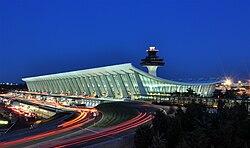
The Wright Brothers are credited with first flight just south of Virginia at Kitty Hawk, North Carolina. Other early flights took place at Willoughby Spit near Norfolk. In modern times, major commercial airports are located around the state, with many additional general aviation facilities.

For those who wish to live in the past, at least for a visit, the Colonial Parkway, carefully shielded from commercial development, joins Colonial Williamsburg with Yorktown and Jamestown, the three points of the Historic Triangle. By riding the toll free Jamestown Ferry service across the James River, it is even possible to arrive at Jamestown Island by water, with a similar view to that of the first colonists. Virginia's scenic byways include the Skyline Drive in Shenandoah National Park and the Blue Ridge Parkway. Even in busy Northern Virginia, a bucolic interlude is available inside the beltway on the George Washington Memorial Parkway. The state has literally dozens of other stretches of roads designated as scenic byways, and VDOT distributes a free map showing them.

Highways and bridges

Map of Virginia's major cities and roads National-atlas-virginia crop.png
Map of Virginia's major cities and roads

The Virginia State Highway System is an integrated system of roads maintained by the Virginia Department of Transportation (VDOT). As of 2005, the VDOT maintains 57,082 miles (91,865 km) of state highways the third largest system in the United States, after Texas and North Carolina. Interstate 95 and Interstate 81 are the two major north-south highways through Virginia. The Capital Beltway, Interstate 495 crosses the Potomac River in Alexandria and McLean. The Springfield Interchange at the junction of I-95, I-395, and the Capital Beltway, in Springfield, Virginia, south of Washington, D.C. has been reconstructed to improve traffic flow; widening of Woodrow Wilson Bridge was finished in mid-2008. [1] Interstate 66, another heavily traveled route into Washington, DC, connects the Capital Beltway to I81 at Front Royal, Virginia. Interstate 64 runs east-west through the state, from the terminus in Virginia's southeast in Chesapeake running northwest into Richmond, then west through Charlottesville and into West Virginia and beyond. Interstate 77 runs north-south through the state running from the North Carolina state line, goes through Wytheville heads through the Big Walker Mountain and then reaches the West Virginia state line.

Interstate highways

I-81 looking southbound near milepost 245 in Harrisonburg I 81 harrisonburg.jpg
I-81 looking southbound near milepost 245 in Harrisonburg

Virginia has an extensive network of Interstate Highways. The Interstate Highways, totaling 1,118 miles (1,799 km) in Virginia, [2] are freeways designated by the Federal Highway Administration and numbered by the American Association of State Highway and Transportation Officials. They are in a special class with respect to federal funding. These Interstate Highways are as follows:

I-495 (Capital Beltway) in Tysons Corner, with HOT lanes under construction VA 07 2012 I495 HOT facility 3664.JPG
I-495 (Capital Beltway) in Tysons Corner, with HOT lanes under construction

Primary highways

US 301 entering Virginia from Maryland US301southfromMD.jpg
US 301 entering Virginia from Maryland

Primary highways, totaling 8,111 miles (13,053 km), [2] consist of U.S. Routes, designated and numbered by the American Association of State Highway and Transportation Officials, and primary State Routes, designated and numbered by VDOT. Alternate, business, and bypass special routes, as well as wye connections (with a "Y" suffix appended to the number), are all considered primary routes. [3]

Primary routes are generally given numbers under 600. The two exceptions - State Route 785 and State Route 895 - are numbered as Interstate Highway spurs.

Major U.S. highways in Virginia include:

Secondary highways

Virginia has 48,305 miles (77,739 km) of secondary routes. [2] These roads, numbered 600 and up, receive less funding than primary routes. Numbers are only unique within each county, though routes that cross county lines generally keep their numbers.

Under the provisions of the Byrd Road Act of 1932, the secondary roads in most of Virginia's counties are maintained by the Virginia Department of Transportation, an arrangement that a 1998 study found " unusual among the 50 states." (The study also identified such issues as drainage, speed limits, and planning and coordination of roads with development as those local leaders felt should be within their control). [4]

The streets and roads in two counties, Arlington and Henrico, as well as some of the incorporated towns, and all of the independent cities are maintained by the various localities. In the early 21st century, the Virginia General Assembly was considering legislation to allow some additional counties (most likely those in fast-growing areas) to choose to resume control and care for the secondary highways within their boundaries.

National parkways

Skyline Drive Shenandoah SkylineDrive Milemarker103 FallColors.jpg
Skyline Drive

Several national parkways are located in Virginia. These include:

Beltways and bypasses

Northern Virginia

The Capital Beltway circles Washington D.C. through Northern Virginia, Maryland, and a tiny edge of the District of Columbia. The road is signed with Inner Loop and Outer Loop designations.

Hampton Roads

The Hampton Roads Beltway extends 56 miles (90 km) on a long loop through the region, crossing the harbor on two toll-free bridge-tunnel facilities. These crossings are the Hampton Roads Bridge–Tunnel between Phoebus in Hampton and Willoughby Spit in Norfolk and the Monitor–Merrimac Memorial Bridge–Tunnel between Newport News and Suffolk. The Beltway connects with another Interstate highway and three arterial U.S. Highways at Bower's Hill near the northeastern edge of the Great Dismal Swamp. The road is signed with Inner Loop and Outer Loop designations.

Also in Hampton Roads, the Williamsburg area has State Route 199, a semi-circular limited access roadway also named the Humelsine Parkway, which is sometimes locally referred to as the "Williamsburg Beltway."

Richmond

The Richmond area does not officially have a beltway. However, it has two roads that effectively form portions of a beltway, though they do not completely encircle Richmond. These are Interstate 295 in the northwest, northern, and eastern portions, and State Route 288 in the southwest and western areas.

Staunton

Staunton, Virginia's Staunton Beltway is a freeway-style 5-10 mile beltway highway making a complete circle around the city, except for about 5 miles (8.0 km) where it merges on with Interstate 81. The road is currently a 2 lane road, except for some areas to the far east and far west. In the future, the road will be expanded into a full 4 lane road.

Bypasses

Many urban areas in Virginia have roads that bypass the central portions. In some cases, semi-circumferential roadways exist, such as State Route 37 in the Winchester area, and State Route 199 in the Williamsburg and Historic Triangle area.

River and waterway crossings

Major bridges, tunnels, and bridge-tunnels

Chesapeake Bay Bridge-Tunnel 2017-07-12 11 23 10 View south along U.S. Route 13 (Chesapeake Bay Bridge-Tunnel) crossing the North Channel of the Chesapeake Bay in Northampton County, Virginia.jpg
Chesapeake Bay Bridge-Tunnel
James River Bridge, near Hampton Roads in Virginia. When completed in 1928, it was the longest bridge in the world over water. James-river-bridge.jpg
James River Bridge, near Hampton Roads in Virginia. When completed in 1928, it was the longest bridge in the world over water.

In the Hampton Roads area, there are three bridge-tunnel complexes known as the Hampton Roads Bridge–Tunnel, the Monitor–Merrimac Memorial Bridge–Tunnel, and the Chesapeake Bay Bridge–Tunnel. The Chesapeake Bay Bridge–Tunnel in particular is a toll facility that links the region with Virginia's Eastern Shore, which carries US 13. Completed in 1964, at over 17 miles (27 km), it is the longest bridge-tunnel in the world. Two tunnels and numerous bridges span portions of the Elizabeth River. The James River Bridge, opened in 1928, and rebuilt in the 1970s, spans the James River near its mouth and north of the Monitor–Merrimac Memorial Bridge–Tunnel. [5]

Virginia has many crossings of its rivers and waterways. Listed alphabetically, some of the larger named crossings include:

Ferry systems

Motor vehicle services
Jamestown Ferry JamestownFerry.jpg
Jamestown Ferry

The Jamestown Ferry (also known as the Jamestown-Scotland Ferry) is an automobile ferry system on the James River connecting Jamestown in James City County with Scotland in Surry County. It carries State Route 31. Operated by VDOT, it is the only 24-hour state-run ferry operation in Virginia and has over 90 employees. It operates four ferryboats, the Pocahontas, the Williamsburg, the Surry, and the Virginia. The facility is toll-free.

The VDOT operates other toll-free cable-guided ferries: the Merry Point ferry, which crosses the western end of the Corrotoman River in Lancaster County; the Sunnybank Ferry, crossing the Little Wicomico River in Northumberland County; and the Hatton Ferry, one of the last two poled ferries in the United States.

Pedestrian ferry services

Additionally, Hampton Roads Transit's Paddlewheel Ferry on the Elizabeth River operates service (no motor vehicles) between Portsmouth and Norfolk and boasts the world's first natural gas-powered pedestrian ferry.

Commuter bus service

Northern Virginia has several commuter bus operations. They include

Local public transportation

Transit bus and paratransit systems

A Hampton Roads Transit bus travels northbound on Pacific Avenue in Virginia Beach. Hampton Roads Transit 937.jpg
A Hampton Roads Transit bus travels northbound on Pacific Avenue in Virginia Beach.

Virginia has a number of publicly funded providers of transit bus and paratransit services. They include:

Subway systems

Subway service is available to residents of northern Virginia. The Washington Metro connects suburban communities to Washington, D.C., Dulles International Airport, and National Airport. Four lines operate in Virginia: the Silver Line, the Orange Line, the Blue Line, and the Yellow Line.

Light rail and streetcar projects

The Tide light rail Tidelrt 01142011.JPG
The Tide light rail

Light rail service, called The Tide, started full service in Norfolk on August 19, 2011. A future extension to the Virginia Beach oceanfront was under consideration until it was voted down in a 2016 city referendum.

A study undertaken in 2010 examined the possibility of a rapid transit line along Broad Street in Richmond, for which light rail was considered. Instead, a Bus Rapid Transit option was chosen for its lower capital costs, and the GRTC Pulse BRT line opened in 2018.

Intercity bus services

Intercity bus service is provided by Greyhound Lines, Megabus, OurBus, and a few Chinatown bus lines. In 2017 the Virginia Department of Rail and Public Transportation started the Virginia Breeze, contracted to Megabus, and it now has three routes, from the North Carolina border to Washington, DC. [6]

Railroads

Passenger rail

Virginia passenger rail
BSicon CONTg.svg
BSicon INT.svg
Crystal City
WMATA Metro Logo small.svg
BSicon INT.svg
Alexandria
BSicon LOGO Amtrak2.svg WMATA Metro Logo small.svg
BSicon KRW+l.svg
BSicon KRWr.svg
BSicon KRWl.svg
BSicon KRW+r.svg
Backlick Road
BSicon HST.svg
BSicon INT.svg
Franconia–Springfield
WMATA Metro Logo small.svg
Rolling Road
BSicon HST.svg
BSicon HST.svg
Lorton
BSicon LOGO Amtrak2.svg
Burke Centre
BSicon HST.svg
BSicon KBHFaq.svg
BSicon ABZg+r.svg
Lorton
Clifton
events
only
BSicon pHST.svg
BSicon HST.svg
Woodbridge
BSicon LOGO Amtrak2.svg
Manassas Park
BSicon HST.svg
BSicon HST.svg
Rippon
BSicon LOGO Amtrak2.svg
Manassas
BSicon HST.svg
BSicon HST.svg
Quantico
BSicon LOGO Amtrak2.svg
Broad Run
BSicon HST.svg
BSicon HST.svg
Brooke
Culpeper
BSicon HST.svg
BSicon HST.svg
Leeland Road
BSicon BS2l.svg
BSicon STRl.svg
BSicon BS2c3.svg
BSicon STR+r.svg
BSicon HST.svg
Fredericksburg
BSicon LOGO Amtrak2.svg
Charlottesville
BSicon STRc2.svg
BSicon BHF.svg
BSicon STR3+1h.svg
BSicon BS2c4.svg
BSicon HST.svg
Spotsylvania
Staunton
BSicon HST+1.svg
BSicon STR+c4.svg
BSicon HST.svg
Ashland
Clifton Forge
BSicon HST.svg
BSicon STR.svg
BSicon BHF.svg
Richmond
Staples Mill Road
BSicon CONT3+g.svg
BSicon STR.svg
BSicon bSHI2lr.svg
Lynchburg
BSicon BHF.svg
BSicon STR.svg
BSicon HST.svg
Richmond
Main Street
Roanoke
BSicon KBHFaq.svg
BSicon ABZgr.svg
BSicon STR.svg
BSicon HST.svg
Williamsburg
Danville
BSicon BHF.svg
BSicon STR.svg
BSicon KBHFe.svg
Newport News
BSicon CONTf.svg
BSicon HST.svg
Petersburg
BSicon ABZgl.svg
BSicon KINTeq.svg
Norfolk
BSicon TRAM.svg
BSicon STR.svg
BSicon CONTf.svg

Key
BSicon LOGO Amtrak2.svg
BSicon HST.svg
Amtrak only
Virginia Railway Express.svg
BSicon HST.svg
Virginia Railway Express
Virginia Railway Express commuter train Virginia Railway Express train.jpg
Virginia Railway Express commuter train

Virginia is served by passenger rail service provided by Amtrak and Virginia Railway Express commuter rail. The Virginia Department of Rail and Public Transportation (DRPT) has projects underway for establishing high speed passenger rail service from Washington, D.C., to Hampton Roads and Raleigh, North Carolina, as part of the Southeast High Speed Rail Corridor (SEHSR). In addition, Virginia expands Amtrak service through grants to freight railroads to upgrade track, in exchange for more passenger carriage, and it purchases under-used or abandoned right-of-way from the railroads (rail-banking). [7] North Carolina also does this, as well as supporting Amtrak lines directly and owning a railroad, [8] and is in a rail compact with Virginia. Ridership levels tend to bear out the investment, which is incremental and focused on areas with high demand. [9] The Amtrak Northeast Regional has been enhanced to Newport News and extended to a new Norfolk station. Another new station opened in Roanoke, and the Lynchburg station was rehabilitated to serve both the Crescent and the Northeast Regional . The busiest stations are in Richmond, Northern Virginia and Charlottesville. [10] Lorton, Virginia, is the northern terminus for Amtrak's non-stop Auto Train , which allows passengers to take a motor vehicle on an overnight trip between there and Sanford, Florida, just outside of Orlando. The thrice-weekly Cardinal runs through Piedmont and Western Virginia to Chicago.

A Transdominion Express was proposed in the early 2000's to serve Southside Virginia.

Freight railroads

Virginia is served by major Class I railroads Norfolk Southern and CSX. There are many short line railroads, including the Buckingham Branch Railroad, the state's largest. Norfolk Southern, a Fortune 500 company, has its headquarters in Norfolk.

Ports

Air and Space

Washington Dulles International Airport Washington Dulles International Airport at Dusk.jpg
Washington Dulles International Airport

Virginia is served by a number of major commercial airports.

Top Virginia airports by total passengers boarded

AirportMetropolitan areaCityIATA airport codeCY 2008
Boarding [11]
National rank
Washington Dulles International Airport Washington, DC Dulles IAD11,348,77521
Ronald Reagan Washington National Airport Washington, DC Arlington DCA8,704,46628
Norfolk International Airport Hampton Roads Norfolk ORF1,786,59469
Richmond International Airport Richmond Richmond RIC1,733,66870
Newport News/Williamsburg International Airport Hampton Roads Newport News PHF504,292116

Other important airports include:

The state is also home to two spaceports:

Nautical

Elizabeth River in Norfolk Elizabeth River at NNSY.jpg
Elizabeth River in Norfolk

Hampton Roads has become known as the "world's greatest natural harbor". The port is located only 18 miles (29 km) from open ocean on one of the world's deepest, natural ice-free harbors. Since 1989, Hampton Roads has been the mid-Atlantic leader in U.S. waterborne foreign commerce and is ranked second nationally behind the Port of South Louisiana based on export tonnage. When import and export tonnage are combined, the Port of Hampton Roads ranks as the third largest port in the country (following the ports of New Orleans/South Louisiana and Houston. In 1996, Hampton Roads was ranked ninth among major U.S. ports in vessel port calls with approximately 2,700. In addition, this port is the U.S. leader in coal exports. The coal loading facilities in the Port of Hampton Roads are able to load in excess of 65 million tons annually, giving the port the largest, most efficient and modern coal loading facilities in the world.

The Hampton Roads region's economic base is largely port-related, including shipbuilding, ship repair, naval installations, cargo transfer and storage, and manufacturing related to the processing of imports and exports. Associated with the ports' military role are almost 50,000 federal civilian employees.

The harbor of Hampton Roads is an important highway of commerce, especially for the cities of Norfolk, Portsmouth, and Newport News. In Portsmouth, a few miles up the Elizabeth River, Norfolk Naval Shipyard is located Newport News Shipbuilding & Dry Dock Company is located a short distance up the James River. There are also several smaller shipyards, numerous docks and terminals. Massive coal loading piers and facilities were established in the late 19th and early 20th centuries by the Chesapeake and Ohio Railway (C&O), Norfolk and Western Railway (N&W), and Virginian Railway (VGN). The latter two were predecessors of the Norfolk Southern Railway, a Class I railroad headquartered in Norfolk that exports coal from a large facility at Lambert's Point on the Elizabeth River. CSX Transportation now serves the former C&O facility at Newport News.

Virginia has extensive waterways. In addition to the lower portion of the Chesapeake Bay and the harbor of Hampton Roads, navigable rivers include:

The Atlantic Intracoastal Waterway passes through eastern Virginia.

The state operates an inland port facility near Front Royal.

See also

Related Research Articles

<span class="mw-page-title-main">Interstate 66</span> Interstate in Virginia and DC

Interstate 66 (I-66) is an east–west Interstate Highway in the eastern United States. The highway runs from an interchange with I-81 near Middletown, Virginia, on its western end to an interchange with U.S. Route 29 (US 29) in Washington, D.C., at the eastern terminus. Much of the route parallels US 29 or State Route 55 (SR 55) in Virginia. I-66 has no physical or historical connection to the famous US 66, which was located in a different region of the United States.

<span class="mw-page-title-main">Hampton Roads</span> Body of water and metropolitan area in the U.S. states of Virginia and North Carolina

Hampton Roads is the name of both a body of water in the United States that serves as a wide channel for the James, Nansemond and Elizabeth rivers between Old Point Comfort and Sewell's Point where the Chesapeake Bay flows into the Atlantic Ocean, and the surrounding metropolitan region located in the southeastern Virginia and northeastern North Carolina portions of the Tidewater Region.

<span class="mw-page-title-main">James River</span> River in Virginia, United States

The James River is a river in Virginia that begins in the Appalachian Mountains and flows 348 miles (560 km) to the Chesapeake Bay. The river length extends to 444 miles (715 km) if the Jackson River is included, the longer of its two headwaters. It is the longest river in Virginia. Jamestown and Williamsburg, Virginia's first colonial capitals, and Richmond, Virginia's current capital, lie on the James River.

<span class="mw-page-title-main">Interstate 664</span> Highway in Virginia

Interstate 664 (I-664) is an auxiliary Interstate Highway in the US state of Virginia. The Interstate runs 20.79 miles (33.46 km) from I-64 and I-264 in Chesapeake north to I-64 in Hampton. I-664 forms the west side of the Hampton Roads Beltway, a circumferential highway serving the Hampton Roads metropolitan area. The Interstate crosses Hampton Roads via the Monitor–Merrimac Memorial Bridge–Tunnel (MMMBT) between Suffolk and Newport News. I-664 is connected to the other major cities of the metropolitan area—Portsmouth, Norfolk, and Virginia Beach—by I-264. The Interstate also has a connection to Portsmouth through State Route 164 (SR 164) and to Suffolk via U.S. Route 13 (US 13), US 58, and US 460.

<span class="mw-page-title-main">Hampton Roads Bridge–Tunnel</span> Bridge–tunnel connecting Virginia cities Norfolk and Hampton

The Hampton Roads Bridge–Tunnel (HRBT) is a 3.5-mile-long (5.6 km) Hampton Roads crossing for Interstate 64 (I-64) and US Route 60 (US 60). It is a four-lane facility comprising bridges, trestles, artificial islands, and tunnels under the main shipping channels for Hampton Roads harbor in the southeastern portion of Virginia in the United States.

The Hampton Roads Beltway is a loop of Interstate 64 and Interstate 664, which links the communities of the Virginia Peninsula and South Hampton Roads which surround the body of water known as Hampton Roads and comprise much of the region of the same name in the southeastern portion of Virginia in the United States. It crosses the harbor of Hampton Roads at two locations on large four-laned bridge-tunnel facilities: the eastern half carries Interstate 64 and uses the Hampton Roads Bridge-Tunnel and the western half carries Interstate 664 and uses the Monitor-Merrimac Memorial Bridge-Tunnel. The beltway has the clockwise direction signed as the Inner Loop, and the counter-clockwise direction signed as the Outer Loop. The entire beltway, including the bridge-tunnels, is owned and operated by the Virginia Department of Transportation.

The Virginia Department of Transportation (VDOT) is the agency of the state government responsible for transportation in the state of Virginia in the United States. VDOT is headquartered at the Virginia Department of Highways Building in downtown Richmond. VDOT is responsible for building, maintaining, and operating the roads, bridges, and tunnels in the commonwealth. It is overseen by the Commonwealth Transportation Board, which has the power to fund airports, seaports, rail, and public transportation.

<span class="mw-page-title-main">Interstate 264 (Virginia)</span> Highway in Virginia

Interstate 264 (I-264) is an Interstate Highway in the US state of Virginia. It serves as the primary east–west highway through the South Hampton Roads region in southeastern Virginia. The route connects the central business districts of Chesapeake, Portsmouth, Norfolk, and Virginia Beach and serves as the most direct link between those cities and the resort beaches along Virginia's Atlantic coast.

<span class="mw-page-title-main">Jamestown Ferry</span>

The Jamestown Ferry is a free automobile and bus ferry service across a navigable portion of the James River in Virginia. It carries State Route 31, connecting Jamestown in James City County with Scotland Wharf in Surry County.

<span class="mw-page-title-main">Interstate 564</span>

Interstate 564 (I-564) is an Interstate Highway in the US state of Virginia. Known as Admiral Taussig Boulevard, after US Navy Rear Admiral Edward D. Taussig, the Interstate runs 3.03 miles (4.88 km) from State Route 337 (SR 337) east to I-64 within the city of Norfolk. I-564 is the primary access highway to Naval Station Norfolk, the world's largest naval base. The Interstate also links I-64 with Norfolk International Terminals via SR 406 and the Wards Corner area of Norfolk through connections with U.S. Route 460 (US 460) and SR 165.

<span class="mw-page-title-main">Transportation in Richmond, Virginia</span>

Transportation in Richmond, Virginia and its immediate surroundings include land, sea and air modes. This article includes the independent city and portions of the contiguous counties of Henrico and Chesterfield. While almost all of Henrico County would be considered part of the Richmond area, southern and eastern portions of Chesterfield adjoin the three smaller independent cities of Petersburg, Hopewell, and Colonial Heights, collectively commonly called the Tri-Cities area. A largely rural section of southwestern Chesterfield may be considered not a portion of either suburban area.

<span class="mw-page-title-main">Virginia State Route 168</span> State highway in Virginia, United States

State Route 168 is a primary state highway in the South Hampton Roads region of the U.S. state of Virginia. It runs from the border with North Carolina through the independent cities of Chesapeake and Norfolk where it ends in the Ocean View area near the Hampton Roads Bridge-Tunnel.

<span class="mw-page-title-main">U.S. Route 17 in Virginia</span> State highway in Virginia

U.S. Route 17 (US 17) is a part of the United States Numbered Highway System that runs from Punta Gorda, Florida, to Winchester, Virginia. In Virginia, the U.S. Highway runs 255.83 miles (411.72 km) from the North Carolina state line in Chesapeake north to its northern terminus at US 11, US 50, and US 522 in Winchester. US 17 is a major highway in the eastern half of Virginia. The U.S. Highway connects the Albemarle Region of North Carolina with the Hampton Roads metropolitan area. Within the urban area, US 17 passes through the South Hampton Roads cities of Chesapeake, Portsmouth, and Suffolk and the Virginia Peninsula city of Newport News. Between Yorktown and Fredericksburg, the U.S. Highway serves as the primary highway of the Middle Peninsula. At Fredericksburg, US 17 leaves the Atlantic Plain; the highway passes through the Piedmont town of Warrenton and crosses the Blue Ridge Mountains on its way to Winchester in the Shenandoah Valley. The route from Tappahannock to Winchester roughly follows the Confederate march during the Civil War to Gettysburg.

Transportation in New York is made up of some of the most extensive and one of the oldest transportation infrastructures in the country. Engineering difficulties because of the terrain of the State of New York and the unique issues of New York City brought on by urban crowding have had to be overcome since the state was young. Population expansion of the state generally followed the path of the early waterways, first the Hudson River and then the Erie Canal. Today, railroad lines and the New York State Thruway follow the same general route.

<span class="mw-page-title-main">Interstate 64 in Virginia</span> Highway in Virginia

Interstate 64 (I-64) in the US state of Virginia runs east–west through the middle of the state from West Virginia to the Hampton Roads region, for a total of 299 miles (481 km). From the West Virginia state line to Chesapeake, it passes through the major cities of Lexington, Staunton, Charlottesville, the state capital of Richmond, Newport News, Hampton, and Norfolk. It is notable for crossing the mouth of the harbor of Hampton Roads on the Hampton Roads Bridge–Tunnel (HRBT), the first bridge–tunnel to incorporate artificial islands, concurrent with U.S. Route 60 (US 60). Also noteworthy is a section through Rockfish Gap, a wind gap in the Blue Ridge Mountains, which was equipped with an innovative system of airport-style runway lighting embedded into the pavement to aid motorists during periods of poor visibility due to fog or other conditions.

Located in the southeastern corner of the state, Norfolk is economically and culturally important to Virginia. A variety of transportation modes have developed around the city's importance and somewhat unusual geography.

Virginia Beach, Virginia's development is tied to the establishment of a transportation infrastructure that allowed access to the Atlantic shoreline.

The city of Williamsburg, Virginia has a full range of transport facilities. Williamsburg is served by the Newport News/Williamsburg International Airport, and by two larger but more distant airports. The city is linked to several Interstate and State highways. A transport hub - the Williamsburg Transportation Center - serves bus and rail passengers. Motor traffic is restricted in the historic area, and the city as a whole is more "walkable" than the US norm. Cycling routes are also being provided.

<span class="mw-page-title-main">Transportation in Hampton Roads</span>

Historically, the harbor was the key to the Hampton Roads area's growth, both on land and in water-related activities and events. Ironically, the harbor and its tributary waterways were both important transportation conduits and obstacles to other land-based commerce and travel. For hundreds of years, state and community leaders have worked to develop solutions to accommodate both.

<span class="mw-page-title-main">Bowers Hill Interchange</span> Interchange in Virginia

The Bowers Hill interchange is a large interchange complex where the Hampton Roads Beltway intersects with Interstate 264 (I-264) as well as Military Highway, which carries the three U.S. Highways. It is named for the unincorporated community surrounding it, Bowers Hill, Virginia, which itself is a part of the independent city of Chesapeake.

References

  1. "Project Overview - Schedule". October 9, 2007. Archived from the original on 2007-11-27. Retrieved 2007-12-08.
  2. 1 2 3 "Virginia's Highway System". Virginia Department of Transportation. 2007-06-28. Retrieved 2008-04-19. Interstate - 1,118 miles (1,799 km) of four-to-ten lane highways that connect states and major cities. Primary - 8,111 miles (13,053 km) of two-to-six-lane roads that connect cities and towns with each other and with interstates. Secondary - 48,305 miles (77,739 km) of local connector or county roads. These generally are numbered 600 and above. Arlington and Henrico counties maintain their own county roads. Frontage - 333 miles (536 km) of frontage roads. A separate system includes 10,561 miles (16,996 km) of urban streets, maintained by cities and towns with the help of state funds. Virginia's cities are independent of its counties. Henrico County (1,279 miles) and Arlington County (359 miles) maintain their own roads with VDOT funds. There is an additional 39 miles (63 km) of toll roads maintained by others.
  3. "Virginia Route Index" (PDF). (239 KB), revised July 1, 2003
  4. http://www.virginiadot.org/vtrc/main/online_reports/pdf/98-r29.pdf [ bare URL PDF ]
  5. "James River Bridge (US-17)". Roads to the Future. 2004-06-05. Retrieved 2007-12-08.
  6. "Daily interstate bus service returns to Martinsville and Danville and Washington, D.C."
  7. "Former Virginia Governor Ralph Northam - December".
  8. North Carolina Railroad
  9. "Lynchburg-to-D.C. Train among Amtrak's few profitable routes".
  10. https://www.amtrak.com/content/dam/projects/dotcom/english/public/documents/corporate/statefactsheets/VIRGINIA17.pdf [ bare URL PDF ]
  11. FAA - Passenger Boarding and All-Cargo Data for U.S. Airports