
Chesterfield County is located just south of Richmond in the Commonwealth of Virginia. The county's borders are primarily defined by the James River to the north and the Appomattox River to the south. Its county seat is Chesterfield Court House.
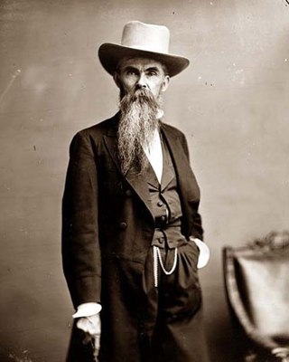
William Mahone was an Confederate States Army General, civil engineer, railroad executive, prominent Virginia Readjuster and ardent supporter of former slaves.
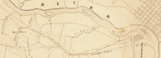
The Chesterfield Railroad was located in Chesterfield County, Virginia. It was a 13-mile (21-kilometer) long mule-and-gravity powered line that connected the Midlothian coal mines with wharves that were located at the head of navigation on the James River just below the Fall Line at Manchester. It began operating in 1831 as Virginia's first common carrier railroad.

Claude "Claudius" Crozet was a soldier, educator, and civil engineer.

The Readjuster Party was a bi-racial state-level political party formed in Virginia across party lines in the late 1870s during the turbulent period following the Reconstruction era that sought to reduce outstanding debt owed by the state. Readjusters aspired "to break the power of wealth and established privilege" among the planter elite of whites in the state and to promote public education. The party's program attracted support among both white people and African-Americans.
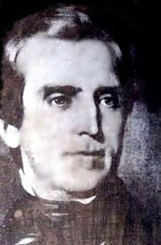
Moncure Robinson was an American civil engineer and railroad executive. He was one of the leading engineers for railroad survey and construction projects from the 1820s to the 1840s. He conducted surveys for and constructed multiple railroad lines including the Danville and Pottsville Railroad, the Allegheny Portage Railroad, the Chesterfield Railroad, the Petersburg Railroad, the Richmond and Petersburg Railroad, the Richmond, Fredericksburg and Potomac Railroad, the Winchester and Potomac Railroad, the Raleigh and Gaston Railroad, and the Philadelphia & Reading Railroad.
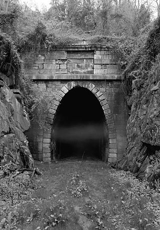
The Blue Ridge Tunnel is a historic railroad tunnel built during the construction of the Blue Ridge Railroad in the 1850s. The tunnel was the westernmost and longest of four tunnels engineered by Claudius Crozet to cross the Blue Ridge Mountains at Rockfish Gap in central Virginia.
The Southside Railroad was formed in Virginia in 1846. Construction was begun in 1849 and completed in 1854. The 5 ft gauge railroad connected City Point, a port on the James River with the farm country south and west of Petersburg, Virginia, to Lynchburg, Virginia, a distance of about 132 miles (212 km).
The James River and Kanawha Turnpike was built to facilitate portage of shipments of passengers and freight by water between the western reaches of the James River via the James River and Kanawha Canal and the eastern reaches of the Kanawha River.
The Northwestern Turnpike is a historic road in West Virginia, important for being historically one of the major roads crossing the Appalachians, financed by the Virginia Board of Public Works in the 1830s. In modern times, west of Winchester, Virginia, U.S. Route 50 follows the path of the Northwestern Turnpike into West Virginia, whose major Corridor D project follows the western section of the original Northwestern Turnpike.

Transportation in the Commonwealth of Virginia is by land, sea and air. Virginia's extensive network of highways and railroads were developed and built over a period almost 400 years, beginning almost immediately after the founding of Jamestown in 1607, and often incorporating old established trails of the Native Americans.

Transportation in Richmond, Virginia and its immediate surroundings include land, sea and air modes. This article includes the independent city and portions of the contiguous counties of Henrico and Chesterfield. While almost all of Henrico County would be considered part of the Richmond area, southern and eastern portions of Chesterfield adjoin the three smaller independent cities of Petersburg, Hopewell, and Colonial Heights, collectively commonly called the Tri-Cities area. A largely rural section of southwestern Chesterfield may be considered not a portion of either suburban area.

Harrison Holt Riddleberger was a Virginia lawyer, newspaper editor and politician from Shenandoah County. A Confederate States Army officer who at various times aligned with the Conservative Party of Virginia, the Readjuster Party and the Democratic Party, Riddleberger served in both houses of the Virginia General Assembly, which elected him for one term as U.S. Senator.

Covington and Ohio Railroad was part of a planned railroad link between Eastern Virginia and the Ohio River in the 1850s. The mountainous region of the Allegheny Front of the Appalachian Plateau between an existing canal, railroads and navigable rivers represented a formidable obstacle.
The Petersburg Railroad ran from Petersburg, Virginia, south to Garysburg, North Carolina, from which it ran to Weldon via trackage rights over the Seaboard and Roanoke Railroad.

U.S. Route 50 is a transcontinental highway which stretches from Ocean City, Maryland to West Sacramento, California. In the U.S. state of Virginia, US 50 extends 86 miles (138 km) from the border with Washington, D.C. at a Potomac River crossing at Rosslyn in Arlington County to the West Virginia state line near Gore in Frederick County.

Lemuel Chenoweth was a carpenter, legislator and self-taught architect. He is best known as one of 19th century America's master covered bridge builders.
The Staunton–Parkersburg Turnpike was built in what is now the U.S. states of Virginia and West Virginia during the second quarter of the 19th century to provide a roadway from Staunton, Virginia and the upper Shenandoah Valley to the Ohio River at present-day Parkersburg, West Virginia. Engineered by Claudius Crozet through the mountainous terrain, it was a toll road partially funded by the Virginia Board of Public Works. Control of this road became crucial during the American Civil War. Today, the Staunton-Parkersburg Turnpike can be largely traversed by following West Virginia Route 47 east from Parkersburg to Linn, then U.S. Route 33 east through Weston and Buckhannon to Elkins, then U.S. Route 250 southeast through Beverly, Huttonsville, crossing the West Virginia/Virginia state line to Staunton, Virginia.

The history of turnpikes and canals in the United States began with work attempted and accomplished in the original thirteen colonies, predicated on European technology. After gaining independence, the United States grew westward, crossing the Appalachian Mountains with the admission of new states and then doubling in size with the Louisiana Purchase in 1803. The only means of transportation at the time between the coastal states and interior lands remained on water, by canoe, boat and ship, or over land on foot and by pack animal. Recognizing the success of Roman roads in unifying that empire, political and business leaders in the United States began to construct roads and canals to connect the disparate parts of the nation.
Moorefield and North Branch Turnpike was a turnpike in the U.S. state of Virginia built to facilitate travel and commerce between the Baltimore and Ohio Railroad at Green Spring on the North Branch Potomac River and Moorefield. Today, Green Spring Road, Harriott-Wappocomo Road, and West Virginia Route 28 encompass most of the Moorefield and North Branch Turnpike's original route.