Transportation in New York (state)

Last updated
Transportation in the State of New York
Overview
LocaleThe State of New York and surrounding regions
Transit type Rapid transit, commuter rail, buses, private automobile, ferry, Taxicab, bicycle, pedestrian

Transportation in New York is made up of some of the most extensive and one of the oldest transportation infrastructures in the country. Engineering difficulties because of the terrain of the State of New York and the unique issues of New York City brought on by urban crowding have had to be overcome since the state was young. Population expansion of the state generally followed the path of the early waterways, first the Hudson River and then the Erie Canal. Today, railroad lines and the New York State Thruway follow the same general route.

Contents

History

The Post Road in New York BPR NY map.png
The Post Road in New York

Transportation was used early on to support industry and commerce in the State of New York. The Boston Post Road, between what then the relatively small City of New York and Boston, began as a path to deliver the post using post riders (the first ride to lay out the Upper Post Road starting January 22, 1673), and developed into a wagon, or stage road in later colonial times. During the 19th century, pieces of the road were taken over and improved by turnpike companies. In the 1910s and 1920s, the Lower Post Road alignment (and realignments made to the route) was a National Auto Trail known as the Boston Post Road. Large sections of the various routes are still given the name Boston Post Road, much of it is now U.S. Route 1.

By the American Revolutionary War, the colonial Province of New York was still small and relatively sparsely populated. In the 1790 United States Census, the state had a population of 340,120, placing it behind Virginia (747,610), Pennsylvania (434,373), Massachusetts (378,787). [1] The state grew rapidly after this as New York City grew to become the country's shipping epicenter. On October 24, 1825, the Erie Canal opened and over the next century would make boom towns out of the Upstate cities of Buffalo, Rochester, Syracuse, Rome, Utica and Schenectady. Use of the canal would only decline after 1950. Cities in the State of New York would frequently show up as amongst the largest in the United States during the 19th, and into the early 20th century.

The other major contribution to New York's transportation system was its extensive railroad network. The New York Central Water Level Route was advertised as the world's first four-track railroad, and connected New York City, Buffalo, and the cities in between.

Canals

Early transportation in the State of New York was primarily by rivers and canals. Today, the canals are primarily used for recreation.

Urban mass transit

One of the most famous urban mass transit systems in the world is the New York City Subway. New York City is also served by Port Authority Trans-Hudson (PATH), and an extensive bus system.

Besides New York City, many of the other cities have mass transit systems.

Buffalo Metro Rail serves Buffalo, the second largest city in the state. However, this service also resembles a light rail system.

Defunct

Rochester had a subway system, although it is mostly destroyed. Only a small part exists under the old Erie Canal Aqueduct. In its day, the system would carry people underground on what were essentially streetcars. If the system still existed today, it would probably be described as a light rail service.

Rochester, Utica, and other upstate cities once had streetcar and interurban systems.

Commuter railroads

NJ Transit and Amtrak also serve New York City and its suburbs.

Intercity and International rail

Like most of United States, the only intercity rail passenger service is provided by Amtrak. New York City's Pennsylvania Station is the busiest of Amtrak's rail stations. The most successful of Amtrak's routes, the Northeast Corridor, operates between Washington, D.C., and Boston, Massachusetts. The most popular and heavily used routes in the Amtrak system are those on the Northeast Corridor, which include the Acela Express , and the Northeast Regional .

Amtrak's Empire Service trains provide frequent daily service along the 460-mile (740 km) Empire Corridor between New York City and Niagara Falls. The route was formerly the Water Level Route of the New York Central Railroad to Buffalo and then the former Buffalo and Niagara Falls Railroad. One train, known as the Maple Leaf , continues beyond Niagara Falls to Toronto, Ontario, Canada.

Recently, the state has taken more interest in increasing the frequency and speed of intercity rail, going so far as to propose the creation of a statewide high-speed rail network.

Intercity Bus

New York City is a hub for intercity bus networks in the northeastern United States. The rest of the state is served by intercity buses run by companies such as Megabus, Greyhound Lines, Trailways of New York, OurBus, [2] North Fork Express, [3] Hampton Jitney, Coach USA Short Line and others.

Automobile transportation

New York Thruway

New York State Thruway NYS Thruway Sign.svg
New York State Thruway

The largest single artery in the State of New York is the New York State Thruway, which is more than 400 miles from The Bronx to Buffalo. It follows the Hudson River between New York City and Albany with an Interstate 87 designation and the Erie Canal between Albany and the Pennsylvania border with an Interstate 90 designation.

Parkways

New York is home to many parkways built by Robert Moses. Among his projects are the Brooklyn-Queens Expressway, the Staten Island Expressway, the Cross-Bronx Expressway, the Belt Parkway, the Laurelton Parkway, and many more.

Other parkways include the Cross County Parkway and Saw Mill River Parkway in Westchester, the Taconic State Parkway, the Palisades Interstate Parkway, the Northern State Parkway and the Southern State Parkway (the latter two both in Long Island).

Bridges

New York City

Elsewhere in the State of New York

Tunnels

Most tunnels in the state of New York are within New York City.

Interstates

North-South Interstates

The principal north–south highways are as follows:

  • I-81.svg
  • I-87.svg
  • I-95.svg
  • I-99.svg

Interstate 81 has two auxiliary routes, Interstate 481 and Interstate 781.

Interstate 87 has three auxiliary routes: Interstate 287, Interstate 587, and Interstate 787.

Interstate 95 has three auxiliary routes: Interstate 295, Interstate 495, and Interstate 695.

East-West Interstates

The principal east–west highways are as follows:

Interstate 78 has four auxiliary routes: Interstate 278, Interstate 478, Interstate 678, and Interstate 878. All were planned to connect to Interstate 78, but none of them currently do.

Interstate 84 has one auxiliary route, Interstate 684.

Interstate 86 and Interstate 88 have no auxiliary routes.

Interstate 90 has nine auxiliary routes: Interstate 190, Interstate 290, Interstate 390, Interstate 490, Interstate 590, Interstate 690, Interstate 790, Interstate 890, and Interstate 990.

Other highways

Safety

Between 2010 and 2014, NYS has between 1039 and 1202 yearly road traffic fatalities, that is between 8 and 8.3 fatalities by billion miles traveled. Pedestrian fatalities are between yearly 263 and 336. [6]

In the NY state, pedestrians are one out of 4 fatalities, each year. Those fatalities are due to unsafe actions both from motorists and from pedestrians. [6]

NY state is one of the fives US states with the most pedestrian fatalities: 879 fatalities of which 294 (33%) occurred at intersections. [7]

Bicycle

New York has a system of numbered state bicycle routes. [8]

Transportation in New York City

New York City boasts one of the most extensive urban transportation systems in the world, including two distinct mass transit systems:

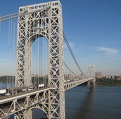
New York City's automobile network is also extensive. It includes many bridges and limited access highways built by Robert Moses, and is integrated with a street grid that dates to the early 19th century.

While extensive, much of New York City's infrastructure is aging and in need of capital investment. Despite the lack of expansion and investment during the past few decades, many infrastructure projects including the Second Avenue Subway, 7 Subway Extension, Fulton Center, and the East Side Access have already started construction during the 2000s.

Transportation on Long Island

Every major form of transportation serves Long Island, including three major airports, railroads and subways, and several major highways. There are historic and modern bridges, recreational and commuter trails, and ferries as well.

The Long Island Expressway, Northern State Parkway, and Southern State Parkway, all products of the automobile-centered planning of Robert Moses, make east–west travel on the island straightforward, if not always quick. Indeed, locals refer to Long Island Expressway as "The World's Longest Parking Lot".

There are currently ten road crossings out of Long Island, all within New York City limits at the extreme western end of the island. Plans for a Long Island Sound link at various locations in Nassau and Suffolk Counties have been discussed for decades, but there are currently no firm plans to construct such a crossing.

The Long Island Rail Road is the busiest commuter railroad system in North America, carrying an average of 282,400 customers each weekday on 728 daily trains. Chartered on April 24, 1834, it is also the oldest railroad still operating under its original name. [9]

Proposals

Commuter rail

See:

Mass transit

Proposed light rail systems

New York presently only boasts the Buffalo Metro Rail, which is arguably a light rail system. Proposals include:

See also

Related Research Articles

<span class="mw-page-title-main">Transportation in Boston</span> Overview of transportation in Boston, Massachusetts, United States

Transportation in Boston includes roadway, subway, regional rail, air, and sea options for passenger and freight transit in Boston, Massachusetts. The Massachusetts Port Authority (Massport) operates the Port of Boston, which includes a container shipping facility in South Boston, and Logan International Airport, in East Boston. The Massachusetts Bay Transportation Authority (MBTA) operates bus, subway, short-distance rail, and water ferry passenger services throughout the city and region. Amtrak operates passenger rail service to and from major Northeastern cities, and a major bus terminal at South Station is served by varied intercity bus companies. The city is bisected by major highways I-90 and I-93, the intersection of which has undergone a major renovation, nicknamed the Big Dig.

<span class="mw-page-title-main">New York Central Railroad</span> American Class I railroad (1853–1968)

The New York Central Railroad was a railroad primarily operating in the Great Lakes and Mid-Atlantic regions of the United States. The railroad primarily connected greater New York and Boston in the east with Chicago and St. Louis in the Midwest, along with the intermediate cities of Albany, Buffalo, Cleveland, Cincinnati, Detroit, Rochester and Syracuse. New York Central was headquartered in New York City's New York Central Building, adjacent to its largest station, Grand Central Terminal.

The Lake Shore and Michigan Southern Railway, established in 1833 and sometimes referred to as the Lake Shore, was a major part of the New York Central Railroad's Water Level Route from Buffalo, New York, to Chicago, Illinois, primarily along the south shore of Lake Erie and across northern Indiana. The line's trackage remains a major rail transportation corridor used by Amtrak passenger trains and several freight lines; in 1998, its ownership was split at Cleveland between CSX Transportation to the east and Norfolk Southern Railway in the west.

<span class="mw-page-title-main">New York Connecting Railroad</span> Freight train infrastructure in Queens

The New York Connecting Railroad or NYCR is a rail line in the borough of Queens in New York City. It links New York City and Long Island by rail directly to the North American mainland. Amtrak, CSX, Canadian Pacific Railway, Providence and Worcester Railroad and New York and Atlantic Railway (NYAR) currently use the line. It runs from the Hell Gate Bridge over the East River to Fresh Pond Junction yard in Glendale in Queens. It was completed in 1917. Amtrak uses the northernmost section of the line from Sunnyside Junction in the Woodside section of Queens to the Hell Gate Bridge into the Bronx from which it follows the line north to Boston.

<span class="mw-page-title-main">Rochester subway</span> Former light rail rapid transit line in the city of Rochester, New York

The Rochester Industrial and Rapid Transit Railway, more commonly known as the Rochester subway, was a light rail rapid transit line in the city of Rochester, New York, from 1927 to 1956. The subway was constructed in the bed of the old Erie Canal, which allowed the route to be grade-separated for its entire length. Two miles (3.2 km) of the route through downtown were constructed in a cut-and-cover tunnel that became Broad Street, and the only underground portion of the subway. The Rochester Subway was designed to reduce interurban traffic on city streets, and to facilitate freight interchange between the railroads. The line was operated on a contract basis by New York State Railways until Rochester Transit Corporation (RTC) took over in 1938. The last day of passenger service was June 30, 1956. Portions of the right-of-way were used for expressway construction, while the rest was abandoned and filled in over the years. The largest remaining section is a stretch of tunnel under Broad Street from Exchange Street to the intersection of Court Street and South Avenue.

<span class="mw-page-title-main">Interstate 190 (New York)</span> Highway in New York

Interstate 190 is a north–south auxiliary Interstate Highway in the United States that connects I-90 in Buffalo, New York, with the Canadian border at Lewiston, New York, near Niagara Falls. Officially, I-190 from I-90 north to New York State Route 384 (NY 384) is named the Niagara Thruway and is part of the New York State Thruway system. The remainder, from NY 384 to Lewiston, is known as the Niagara Expressway and is maintained by the New York State Department of Transportation (NYSDOT).

<span class="mw-page-title-main">Transportation in New York City</span> Overview of urban transportation network

The transportation system of New York City is a network of complex infrastructural systems. New York City, being the most populous city in the United States, has a transportation system which includes one of the largest subway systems in the world; the world's first mechanically ventilated vehicular tunnel; and an aerial tramway. New York City is home to an extensive bus system in each of the five boroughs; citywide and Staten Island ferry systems; and numerous yellow taxis and boro taxis throughout the city. Private cars are less used compared to other cities in the rest of the United States.

<span class="mw-page-title-main">Schuylkill Expressway</span> Highway in Pennsylvania

The Schuylkill Expressway, locally known as "the Schuylkill", is a freeway through southern Montgomery County and the city of Philadelphia. It is the easternmost segment of Interstate 76 (I-76) in the U.S. state of Pennsylvania. It extends from the Valley Forge interchange of the Pennsylvania Turnpike in King of Prussia, paralleling its namesake Schuylkill River for most of the route, southeast to the Walt Whitman Bridge over the Delaware River in South Philadelphia. It serves as the primary corridor into Philadelphia from points west. Maintenance and planning are administered through Pennsylvania Department of Transportation (PennDOT) District 6, with the Delaware River Port Authority (DRPA) maintaining the approach to the Walt Whitman Bridge.

<span class="mw-page-title-main">Transportation in Virginia</span> Overview of land sea and air transport systems in Virginia

Transportation in the Commonwealth of Virginia is by land, sea and air. Virginia's extensive network of highways and railroads were developed and built over a period almost 400 years, beginning almost immediately after the founding of Jamestown in 1607, and often incorporating old established trails of the Native Americans.

<span class="mw-page-title-main">Transportation in Richmond, Virginia</span>

Transportation in Richmond, Virginia and its immediate surroundings include land, sea and air modes. This article includes the independent city and portions of the contiguous counties of Henrico and Chesterfield. While almost all of Henrico County would be considered part of the Richmond area, southern and eastern portions of Chesterfield adjoin the three smaller independent cities of Petersburg, Hopewell, and Colonial Heights, collectively commonly called the Tri-Cities area. A largely rural section of southwestern Chesterfield may be considered not a portion of either suburban area.

<span class="mw-page-title-main">Transportation in Pittsburgh</span> Transportation in Pittsburgh, Pennsylvania, United States

Pittsburgh, surrounded by rivers and hills, has a unique transportation infrastructure that includes roads, tunnels, bridges, railroads, inclines, bike paths, and stairways.

<span class="mw-page-title-main">Proposed expansion of the Buffalo Metro Rail</span> Grass-roots organization in Buffalo, New York

Since the Buffalo Metro Rail light rail was proposed in the 1970s, there have been multiple proposals for expanding the system, which is currently a single 6.4-mile (10.3 km) long line. Public officials, agencies and advocacy groups have created plans, with the most recent and formidable being an extension to the town of Amherst. One organization, the Citizens Regional Transportation Corporation (CRTC), promotes the implementation and expansions of light-rail service for the City of Buffalo and the surrounding Buffalo/Niagara region in New York State.

Transportation in Erie, Pennsylvania includes access to most major forms of transportation, including automobile, bus, train, taxi, airplane, and ship. The city generates income through the transportation industry, including train manufacturing and port operations.

<span class="mw-page-title-main">History of transportation in New York City</span> Aspect of history

Transportation in New York City has ranged from strong Dutch authority in the 17th century, expansionism during the industrial era in the 19th century and half of the 20th century, to cronyism during the Robert Moses era. The shape of New York City's transportation system changed as the city did, and the result is an expansive modern-day system of industrial-era infrastructure. New York City, being the most populous city in the United States, has a transportation system which includes one of the largest subway systems in the world; the world's first mechanically ventilated vehicular tunnel; and an aerial tramway.

<span class="mw-page-title-main">Transportation on Long Island</span> Overview of transportation on Long Island

Nearly every major type of transportation serves Long Island, including three major airports, railroads and subways, and several major highways. The New York City Subway only serves the New York City boroughs of Brooklyn and Queens. There are historic and modern bridges, recreational and commuter trails, and ferries, that connect the boroughs of Queens and Brooklyn to Manhattan, the south shore with Fire Island and Long Island's north shore and east end with the state of Connecticut.

<span class="mw-page-title-main">Transportation in New Jersey</span> Overview of the transportation in New Jersey

Transportation in New Jersey utilizes a combination of road, rail, air, and water modes. New Jersey is situated between Philadelphia and New York City, two major metropolitan centers of the Boston-Washington megalopolis, making it a regional corridor for transportation. As a result, New Jersey's freeways carry high volumes of interstate traffic and products. The main thoroughfare for long distance travel is the New Jersey Turnpike, the nation's fifth-busiest toll road. The Garden State Parkway connects the state's densely populated north to its southern shore region. New Jersey has the 4th smallest area of U.S. states, but its population density of 1,196 persons per sq. mi causes congestion to be a major issue for motorists.

Cincinnati has several modes of transportation including sidewalks, roads, public transit, bicycle paths and regional and international airports. Most trips are made by car, with transit and bicycles having a relatively low share of total trips; in a region of just over 2 million people, less than 80,000 trips are made with transit on an average day. The city is sliced by three major interstate highways, I-71, I-74 and I-75, and circled by a beltway several miles out from the city limits. The region is served by two separate transit systems, one on each side of the river. SORTA, on the Ohio side is about 6 times larger than TANK on the Kentucky side. The transit system is largely radial with almost all lines terminating in or departing from Downtown Cincinnati. The city's hills preclude the regular street grid common to many cities built up in the 19th century, and outside of the downtown basin, regular street grids are rare except for in patches of flat land where they're small and oriented according to topography.

<span class="mw-page-title-main">Transportation in Buffalo, New York</span>

Transportation in Buffalo, New York is dominated by automobile use, but other modes of transportation exist in the city.

References

  1. "Heads of Families at the First Census : 1790" (PDF). 2.census.gov. Retrieved September 3, 2019.
  2. "OurBus- the Smart Commuter". ourbus.com. Archived from the original on 17 November 2017. Retrieved 17 January 2022.
  3. "North Fork Express". Northforkexpress.com. Retrieved September 3, 2019.
  4. "Port Authority of New York and New Jersey - George Washington Bridge". Panynj.gov. Retrieved 2010-03-25.
  5. George Washington Bridge turns 75 years old: Huge flag, cake part of celebration, Times Herald-Record , October 24, 2006. "The party, however, will be small in comparison to the one that the Port Authority of New York and New Jersey organized for 5,000 people to open the bridge to traffic in 1931. And it won't even be on 'what is now the world's busiest bridge' for fear of snarling traffic."
  6. 1 2 "New York State : Highway Safety Strategic Plan" (PDF). Nhtsa.gov. 2017. Retrieved September 3, 2019.
  7. "Pedestrian Traffic Fatalities by State : Preliminary Data" (PDF). Ghsa.org. 2017. Retrieved September 3, 2019.
  8. "New York State Bicycle Maps". New York State Department of Transportation . Retrieved February 2, 2011.
  9. "LIRR General Information Page". mta.info. Archived from the original on 22 June 2003. Retrieved 17 January 2022.