Flushing Bay

Last updated
Looking east at Flushing Bay from the promenade near LaGuardia Airport. Flushing Bay.jpg
Looking east at Flushing Bay from the promenade near LaGuardia Airport.

Flushing Bay is a tidal embayment in New York City. It is located on the south side of the East River and stretches to the south near the neighborhood of Flushing, Queens. It is bordered on the west by LaGuardia Airport and the Grand Central Parkway, on the south by Northern Boulevard, and on the east by the neighborhood of College Point. The Flushing River empties into the bay at its southeast corner. A 150-foot-wide navigational channel (46 m) dredged at a depth of 14 feet (4.3 m) runs along much of the bay's length. [1]

Contents

History

Flushing Bay was an important source of food for the Matinecock tribe of Native Americans and early European settlers, providing fish, shellfish, and waterfowl. After the American Civil War, the area surrounding the bay became waterfront resort for the wealthy. The World's Fair Marina, constructed for the 1964 New York World's Fair, is located on the southern end of the bay beside the East Elmhurst neighborhood. The marina is part of Flushing Meadows–Corona Park and it is bordered by the 1.4-mile-long (2.3 km) Flushing Bay Promenade. [2]

On September 21, 1776, the Colonial patriot Nathan Hale was captured by the British Army near a tavern at Flushing Bay after being fingered as a spy. [3] He was hanged the next day on Manhattan Island.[ citation needed ]

The Williamsburgh Yacht Club is located on the east side of Flushing Bay in College Point. It was established in Brooklyn in 1865, but then the yacht club moved to North Beach (now part of the LaGuardia Airport) in 1896. [4]

Wahnetah Boat Club training on Flushing Bay, 1917. Wahnetah Boat Club training on Flushing Bay (1917).jpg
Wahnetah Boat Club training on Flushing Bay, 1917.

The New York City Department of Sanitation's North Shore Marine Transfer Station is located in College Point on the eastern shore of Flushing Bay. From 1954 to 2001, this site was used to transfer garbage from trucks to barges. A new transfer station at the site opened in 2015. [5]

Incidents

Wreckage of USAir Flight 405 lies in the bay on March 22, 1992. F28laguardiacrash1992.jpg
Wreckage of USAir Flight 405 lies in the bay on March 22, 1992.

On March 22, 1992, USAir Flight 405 crashed in the bay shortly after takeoff, and 27 out of the 51 people on board were killed. [6]

On March 5, 2015, Delta Air Lines Flight 1086 skidded off the runway at LaGuardia Airport and stopped a few feet away from Flushing Bay. 24 people were injured and the aircraft was damaged. [7]

Proximity to LaGuardia Airport

The present shoreline of Flushing Bay has been largely altered by the development of LaGuardia Airport. Before the airport opened in December 1939, millions of cubic yards of landfill were added to the western shoreline of the bay to create space for runways. [8] In 1966, the Port Authority extended the northern end of Runway 4 (or 22) by 2,000 feet (610 m) and the western end of Runway 13 (or 31) by 1,500 feet (460 m) by constructing a 50-acre (20 ha), pile-supported concrete deck over parts of Flushing Bay, including the Rikers Island Channel. [9] In the 1990s, about 20 acres (8 ha) of Flushing Bay were filled in to create an overrun at the eastern end of Runway 13 (or 31). To offset the loss of wetlands, new wetlands were constructed adjacent to the airport in Flushing Bay and in Little Neck Bay. [10]

Concerns have arisen given the proximity to a flight path into LaGuardia Airport, [11] although the government of New York City has stated that the design includes adequate safeguards to prevent the facility from attracting flocks of birds that might be harmful to airliners. [12]

Pollution

The Bowery Bay Wastewater Treatment Plant is seen along the Queens shoreline just above the Rikers Island Bridge. LaGuardia Airport and Rikers Island (4430036264).jpg
The Bowery Bay Wastewater Treatment Plant is seen along the Queens shoreline just above the Rikers Island Bridge.

In 1964, a 2,800 ft (850 m)-long dike, commonly known as “the Finger,” was built to protect boats docked at the World's Fair Marina from strong waves. Protruding from LaGuardia Airport, the dike is often cited as the cause for the bad smell that emanates from the bay, especially in the summertime. [13] Flushing Bay and Flushing River have a long history of being used as dumping areas for sewage discharges and industrial waste. While this pollution is a problem in itself, the dike prevents the water in the bay from circulating naturally. Plans to increase circulation have included slicing a waterway through the dike; however, dredging of the bay floor has been the most frequent proposal. [14]

Plans for a 1.7-mile (2.7 km) promenade on Flushing Bay were approved by Queens Community Board 7 in 1987, but were delayed due to a lack of funds. [15] In 1994, a Key House Appropriations subcommittee authorized the money for the U.S. Army Corps of Engineers (USACE) to study dredging the Flushing Bay near where the dike was built. The measure of this plan was drafted by Rep. Thomas J. Manton and was aided by Rep. Nita Lowey. The Port Authority of New York and New Jersey sought final approval during the summer of that year from the City Council to build the $41-million safety overrun on a 20-acre (8.1 ha) landfill. [16] The USACE subsequently allocated $2.7 million toward a feasibility study for a cleanup. [13] In 1999, the Parks Department negotiated a deal with the New York City Department of Environmental Protection. This plan was also to build a 28.5-million-gallon sewer overflow tank under the river to relieve flooding in the area. [15] A redesigned, refurbished Flushing Bay promenade began that May. [17] Though the promenade was reopened in 2001, [17] its "rotten egg" smell remained. [18]

Following repeated complaints about Flushing Bay's "rotten egg smell", a $47 million cleanup of the bay was announced in 2015. [19] [20] As part of the cleanup, a $15.4 million dredging project near the World's Fair Marina was undertaken in 2017. Also during the cleanup, old pilings were removed and replaced with wetlands, a project completed in mid-2018. [21] [22] The city also rebuilt sewer lines leading to the Bowery Bay Wastewater Treatment Plant in nearby Bowery Bay, reducing Flushing Bay's combined sewer overflows by about 225,000,000 US gal (850,000,000 L) per year. [22]

Related Research Articles

<span class="mw-page-title-main">Queens</span> Borough and County in New York, United States

Queens is a borough of New York City, coextensive with Queens County, in the U.S. state of New York. Located on Long Island, it is the largest New York City borough by area. It is bordered by the borough of Brooklyn at the western tip of Long Island, with Nassau County to its east. Queens shares water borders with the boroughs of Manhattan, the Bronx, and Staten Island and with New Jersey.

<span class="mw-page-title-main">Flushing Meadows–Corona Park</span> Public park in Queens, New York

Flushing Meadows–Corona Park, often referred to as Flushing Meadows Park, or simply Flushing Meadows, is a public park in the northern part of Queens in New York City, New York, U.S. It is bounded by I-678 on the east, Grand Central Parkway on the west, Flushing Bay on the north, and Union Turnpike on the south. Flushing Meadows–Corona Park is the fourth-largest public park in New York City, with a total area of 897 acres (363 ha).

<span class="mw-page-title-main">LaGuardia Airport</span> Airport in Queens, New York City

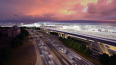
LaGuardia Airport is a civil airport in East Elmhurst, Queens, New York City. Covering 680 acres (280 ha) as of July 1, 2023, the facility was established in 1929 and began operating as a public airport in 1939. It is named after former New York City mayor Fiorello La Guardia.

<span class="mw-page-title-main">Floyd Bennett Field</span> Historic former airport in Brooklyn, New York

Floyd Bennett Field is an airfield in the Marine Park neighborhood of southeast Brooklyn in New York City, along the shore of Jamaica Bay. The airport originally hosted commercial and general aviation traffic before being used as a naval air station. Floyd Bennett Field is currently part of the Gateway National Recreation Area's Jamaica Bay Unit, and is managed by the National Park Service (NPS). While no longer used as an operational commercial, military, or general aviation airfield, a section is still used as a helicopter base by the New York City Police Department (NYPD), and one runway is reserved for hobbyists flying radio-controlled aircraft.

<span class="mw-page-title-main">Land reclamation</span> Creating new land from oceans, seas, riverbeds or lakes

Land reclamation, usually known as reclamation, and also known as land fill, is the process of creating new land from oceans, seas, riverbeds or lake beds. The land reclaimed is known as reclamation ground,reclaimed land, or land fill.

<span class="mw-page-title-main">Grand Central Parkway</span> Highway in New York

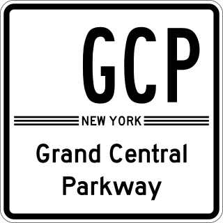
The Grand Central Parkway (GCP) is a 14.61-mile (23.51 km) long parkway that stretches from the Triborough Bridge in New York City to Nassau County on Long Island. At the Queens–Nassau border, it becomes the Northern State Parkway, which runs across the northern part of Long Island through Nassau County and into Suffolk County, where it ends in Hauppauge. The westernmost stretch also carries a short stretch of Interstate 278 (I-278). The parkway runs through Queens and passes the Cross Island Parkway, Long Island Expressway, LaGuardia Airport and Citi Field, home of the New York Mets. The parkway is designated New York State Route 907M (NY 907M), an unsigned reference route. Despite its name, the Grand Central Parkway was not named after Grand Central Terminal.

<span class="mw-page-title-main">East Elmhurst, Queens</span> Neighborhood of Queens in New York City

East Elmhurst is a residential neighborhood in the northwest section of the New York City borough of Queens. It is bounded to the south by Jackson Heights and Corona, to the north and east by Bowery Bay, and to the west by Woodside and Ditmars Steinway. The area also includes LaGuardia Airport, located on the shore of Flushing Bay, LaGuardia Landing Lights Fields, and Astoria Heights.

<span class="mw-page-title-main">College Point, Queens</span> Neighborhood of Queens in New York City

College Point is a working-middle-class neighborhood in the New York City borough of Queens. It is bounded to the south by Whitestone Expressway and Flushing; to the east by 138th Street and Malba/Whitestone; to the north by the East River; and to the west by Flushing Bay. College Point is a mostly residential ethnically diverse community with some industrial areas. The neighborhood is served by several parks and contains two yacht clubs.

The World's Fair Marina is a public marina in Flushing Bay, Queens, New York. It is located at the northern edge of Flushing Meadows–Corona Park, next to a 1.4-mile (2.3 km) long stretch of promenade around Flushing Bay, and near LaGuardia Airport and Citi Field. It is operated by the Marine Division of the Department of Parks and Recreation.

<span class="mw-page-title-main">Flushing River</span> Creek in Queens, New York

The Flushing River, also known as Flushing Creek, is a waterway that flows northward through the borough of Queens in New York City, mostly within Flushing Meadows–Corona Park, emptying into the Flushing Bay and the East River. The river runs through a valley that may have been a larger riverbed before the last Ice Age, and it divides Queens into western and eastern halves. Until the 20th century, the Flushing Creek was fed by three tributaries: Mill Creek and Kissena Creek on the eastern bank, and Horse Brook on the western bank.

<span class="mw-page-title-main">Flushing Airport</span> Airport in College Point, Queens

Flushing Airport is a decommissioned airfield in northern Queens in New York City. It is located in the neighborhood of College Point, near Flushing. The airfield was in operation from 1929 to 1984.

Ditmars Boulevard, originally known as Ditmars Avenue, is a street located in northwest Queens, New York City. It is divided into two segments; one travels through the neighborhood of Ditmars, located within Astoria, and the other acts as a service road for the Grand Central Parkway near LaGuardia Airport in East Elmhurst.

<span class="mw-page-title-main">Bowery Bay</span> Bay in Queens, New York

Bowery Bay is a bay off the East River in New York City. It is located near the Ditmars Steinway area in the neighborhood of Astoria in the New York City borough of Queens. It is bordered on the west by the Bowery Bay Water Pollution Control Plant and on the south and east by LaGuardia Airport.

Hornblower Cruises & Events NOW City Experiences, more commonly known simply as Hornblower is a San Francisco-based charter yacht, dining cruise and ferry service company.

<span class="mw-page-title-main">Aviation in the New York metropolitan area</span>

The New York metropolitan area has the busiest airport system in the United States and the second busiest in the world after London. It is also the most frequently used port of entry and departure for international flights. In 2011, more than 104 million passengers used the airports under the auspices of the Port Authority of New York and New Jersey (PANYNJ). The number increased to 117 million in 2014.

<span class="mw-page-title-main">AirTrain LaGuardia</span> Unbuilt people mover system at LaGuardia Airport in New York City

AirTrain LaGuardia was a proposed 1.5-mile-long (2.4 km) people mover system and elevated railway in New York City, United States, that would provide service to LaGuardia Airport in Queens. It would have connected with the New York City Subway and Long Island Rail Road (LIRR) in Willets Point, similar to how the existing AirTrain JFK system connects John F. Kennedy International Airport’s six terminals to the LIRR in southern Queens at Jamaica station and to the subway at both Sutphin Boulevard–Archer Avenue–JFK Airport station and Howard Beach-JFK Airport station; and how the existing AirTrain Newark station connects Newark Liberty International Airport’s three terminals to NJ Transit Rail Operations and Amtrak at a dedicated station.

<span class="mw-page-title-main">Q72 (New York City bus)</span> Bus route in Queens, New York

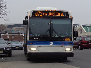
The Q72 bus route constitutes a public transit route along Junction Boulevard and 94th Street in Queens, New York City. It operates between the Rego Park and East Elmhurst neighborhoods of Queens, and extends into LaGuardia Airport at the north end of the borough. It is city-operated under the MTA Bus Company brand of MTA Regional Bus Operations.

<span class="mw-page-title-main">Edgemere Landfill</span> Former landfill in Queens, New York

Edgemere Landfill is a former municipal landfill located in Edgemere on the Rockaway peninsula in Queens, New York City. It is located on a man-made peninsula on the Jamaica Bay shoreline, at the eastern end of the Rockaway peninsula. A portion of the site is currently open to the public as Rockaway Community Park. The entire site is owned by the New York City Department of Parks and Recreation.

References

  1. Chart 12339 (Map). 1 : 10,000. NOAA. June 1, 2008. Retrieved 2009-08-09.
  2. "Flushing Bay Promenade - Historical Sign". New York City Department of Parks & Recreation. Retrieved 2009-08-09.
  3. Dwyer, Jim (June 29, 2010). "New York Spycraft, From Nathan Hale to the Cold War, and Beyond". The New York Times. Retrieved 2011-12-19.
  4. "Williamsburgh Yacht Club History". Williamsburgh Yacht Club. Retrieved 2009-08-09.[ permanent dead link ]
  5. Rosengren, Cole (May 18, 2015). "New York's Garbage System Faces Mounting Challenges of Cost, Carbon and Equity". City Limits. Retrieved 2019-06-03.
  6. "Accident description at the ASN". Aviation Safety Network. March 11, 2008. Retrieved July 16, 2010.
  7. Botelho, Greg (March 5, 2015). "LaGuardia runway reopens after flight skids off it". CNN. Retrieved 2019-06-03.
  8. "LaGuardia Field - predecessor to bigger and better things in the air". Daily News. New York. April 29, 2009. Archived from the original on 2009-05-02. Retrieved 2009-08-09.
  9. "Air Cargo". Port Authority of New York & New Jersey. Archived from the original on April 6, 2009. Retrieved 2009-08-09.
  10. "Birds and Fish Return to Park on Little Neck Bay" (Press release). Port Authority of New York & New Jersey. May 5, 1999. Archived from the original on 2008-12-03. Retrieved 2009-08-09.
  11. Hall, James E. (June 27, 2011). "No Trash, No Crash". The New York Times. Retrieved 2012-01-19.
  12. "Statement by Sanitation Commissioner John J. Doherty on the North Shore Marine Transfer Station Project in College Point, Queens" (Press release). New York City Department of Sanitation. June 9, 2009. Archived from the original on August 7, 2012. Retrieved 2012-01-19.
  13. 1 2 Woodberry Jr., Warren (October 29, 2000). "Big Stink Over Flushing Bay: To Many It Smells of Garbage". Daily News. New York. Retrieved 2016-12-09.
  14. Woodberry Jr., Warren (October 14, 2005). "Let's Flush-Out Bay. Growing Cry to Clean Up Foul Mess". Daily News. The Archives @ Queens Library. New York.
  15. 1 2 Bertrand, Donald (February 4, 1999). "Flushing Bay walkway set to become reality". Daily News. New York. p. 645. Retrieved January 9, 2020 via newspapers.com Open Access logo PLoS transparent.svg .
  16. Bunch, William (May 28, 1994). "Flushing Bay Plan OK'd". Newsday. p. A12. ProQuest   278742236.
  17. 1 2 "A NEW PARK FOR WALKERS, TALKERS, AND PEOPLE WATCHERS : NYC Parks". Flushing Meadows Corona Park News. New York City Department of Parks and Recreation. June 21, 2001. Retrieved January 9, 2020.
  18. Martinez, Jose (August 14, 2002). "A foul smell grows in city". Daily News. New York. p. 2. Retrieved January 9, 2020 via newspapers.com Open Access logo PLoS transparent.svg .
  19. Plitt, Amy (August 26, 2015). "$47M Cleanup Will Rid Flushing Bay of Its Horrible Stench". Curbed NY. Retrieved 2019-06-03.
  20. Honan, Katie (August 26, 2015). "City Launching $47M Clean-Up To End Rotten Egg Smell Near LaGuardia". DNAinfo New York. Archived from the original on 2019-06-03. Retrieved 2019-06-03.
  21. Colangelo, Lisa L. (June 29, 2018). "Bid farewell to Flushing Bay's infamous stench". am New York. Retrieved 2019-06-03.
  22. 1 2 Mohamed, Carlotta (July 16, 2018). "Ecological upgrades clean up polluted Flushing Bay". QNS.com. Retrieved 2019-06-03.

40°46′44″N73°51′24″W / 40.77889°N 73.85667°W / 40.77889; -73.85667