North River (Hudson River)

Last updated

The North River portion of the Hudson River highlighted in red between North Jersey and Manhattan Wpdms terra northriver.jpg
The North River portion of the Hudson River highlighted in red between North Jersey and Manhattan
The river seen from atop The Palisades in New Jersey North River Gutenberg jeh.JPG
The river seen from atop The Palisades in New Jersey

North River (Dutch : Noort Rivier) is an alternative name for the southernmost portion of the Hudson River in the vicinity of New York City and northeastern New Jersey in the United States. [1] [2] [3] [4] [5] [6]

Contents

History

Name

A 1781 map, developed during the Revolutionary War, that refers to the "North River or Hudson River", using both names interchangeably Manhattan1781.jpg
A 1781 map, developed during the Revolutionary War, that refers to the "North River or Hudson River", using both names interchangeably

In the early 17th century, the entire watercourse was named the North River (Dutch: Noort Rivier") by the Dutch colonial empire; by the early 18th century, the term fell out of general use for most of the river's 300+ mile course. [7] The name remains in limited use among local mariners and others [8] [9] [10] and on some nautical charts [11] and maps. The term is also used to describe infrastructure on and under the river, including the North River piers, North River Tunnels, and Riverbank State Park.

The origin of the name North River is generally attributed to the Dutch. [12] In describing the major rivers in the New Netherland colony, they called the present-day Hudson River the "North River", the present-day Connecticut River the "Fresh River", and the Delaware River the "South River". [13] Another theory is that the North River and East River were so named for the direction of travel they permitted once having entered the Upper New York Bay. [14]

At various times, North River has referred to:

The river's history is strongly connected to the shipping industry in the Port of New York and New Jersey, which shifted primarily to Port Newark in the mid-20th century due to the construction of the Holland Tunnel and other river crossings and the advent of containerization. [16] Throughout this multi-century history, the name for the lower portion of the river has remained interchangeable with both North River and Hudson River used to describe it.

19th century

In 1808, U.S. Secretary of the Treasury Albert Gallatin issued a report of proposed locations for transportation and communication internal improvements of national importance. The North River figured prominently among his proposals as the best route toward western and northern lands; similar routes were chosen for the Erie Canal and other early canals built by the New York state.

Gallatin noted the following in reference to the North and Hudson Rivers, writing: [17]

What is called the North River is a narrow and long bay, which in its northwardly course from the harbor of New York breaks through or turns all the mountains, affording a tide navigation for vessels of eighty tons to Albany and Troy, one hundred and sixty miles above New York. This peculiarity distinguishes the North River from all the other bays and rivers of the United States. The tide in no other ascends higher than the granite ridge or comes within thirty miles of the Blue Ridge or eastern chain of mountains. In the North River it breaks through the Blue Ridge at West Point and ascends above the eastern termination of the Catskill or great western chain. A few miles above Troy, and the head of the tide, the Hudson from the north and the Mohawk from the west unite their waters and form the North River. The Hudson in its course upwards approaches the waters of Lake Champlain, and the Mohawk those of Lake Ontario.

20th century

In 1909, two tunnels were under construction: one was called the North River Tunnels, the other, the Hudson Tubes. That year the Hudson–Fulton Celebration was held, commemorating Henry Hudson, the first European to record navigating the river, and Robert Fulton, the first man to use a paddle steamer in America, named the North River Steamboat , to sail up it, leading to controversy over what the waterway should be called. [18] [19] [20]

Much of the shoreline previously used for maritime, rail, and industrial activities has given way to recreational promenades and piers. On the Hudson Waterfront in New Jersey, the Hudson River Waterfront Walkway runs for about 18 miles. In Manhattan, the Hudson River Park runs from Battery Park to 59th Street.

North River on maps

The label "North River" used on a 1997 Hagstrom Map to describe the stretch of the Hudson River between Hudson County, New Jersey and Lower Manhattan North River (Hagstrom map of Manhattan 1997).png
The label "North River" used on a 1997 Hagstrom Map to describe the stretch of the Hudson River between Hudson County, New Jersey and Lower Manhattan

The National Oceanic and Atmospheric Administration's current charts call the lower river the "Hudson", [21] and the United States Geological Survey lists "North River" as an alternative name of the Hudson River without qualifying it as any particular portion of the river. [22]

Hagstrom Maps, formerly the leading mapmaker in the New York metropolitan area and known for occasional quirky and anachronistic names, features, and artifacts on their maps, has labeled all or part of the Hudson adjacent to Manhattan as "North River" on several of its products. For instance, on a 1997 Hagstrom Map of Manhattan, the stretch of river between Hudson County, New Jersey, and Lower Manhattan, roughly corresponding to the location of the North River piers, was labeled "North River", with the label "Hudson River" used above Midtown Manhattan.

On a 2000 map of "Northern Approaches to New York City" included in Hagstrom's New York [State] Road Map, the entire river adjacent to Manhattan was labeled "Hudson River (North River)" with the river further north at Tappan Zee labeled the "Hudson River".

North River piers

Piers along the Hudson shore of Manhattan were formerly used for shipping and berthing ocean-going ships. [23] In shipping notices, they were designated as, for example, "Pier 14, North River". As with the river, the name "North River piers" has largely been supplanted by "Hudson River piers", or just by a pier and number, e.g., "Pier 54". Pier 40 is located at Houston Street, and the numbering of the piers to the north correspond to the nearest numbered street plus 40 – thus, for example, North River Pier 86 is at West 46th Street.

Most of the piers that once existed in lower Manhattan fell into disuse or were destroyed in the last half of the 20th century. The remaining piers are Pier A at the Battery and piers ranging from Pier 25 at North Moore Street to Pier 99 at 59th Street. Many of these piers and the waterfront between them are part of the Hudson River Park which stretches from 59th Street to the Battery. The park, a joint project between New York City and New York State commenced in 1998, consists of several non-contiguous parcels of land and piers totaling 125 acres (0.51 km2), plus another 400 acres (1.6 km2) of the river itself. [24] Several piers were rebuilt for adaptive re-use as part of the park project, with approximately 70% of the planned work complete by 2011. [25]

Status

Chelsea Piers with the RMS Lusitania docked, c. 1910 Chelsea-lusitania.png
Chelsea Piers with the RMS Lusitania docked, c.1910
Rebuilding of Pier 97 in Hudson River Park in July 2011 Pier 97 pile hoisting jeh.jpg
Rebuilding of Pier 97 in Hudson River Park in July 2011
Javits Center behind NY Waterway's West Midtown Ferry Terminal at Pier 79; Weehawken Terminal was located across the river at the base of the Hudson Palisades from its opening in 1884 and its closing in 1959. HudsonRiverJavitsCenter.agr.JPG
Javits Center behind NY Waterway's West Midtown Ferry Terminal at Pier 79; Weehawken Terminal was located across the river at the base of the Hudson Palisades from its opening in 1884 and its closing in 1959.

Railroads and ferries

Railroad and ferry terminals along the North River, c. 1900 New York City Railroads ca 1900.png
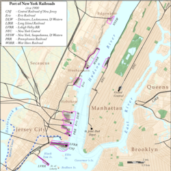
Railroad and ferry terminals along the North River, c.1900

Prior to the opening of the North River Tunnels and the Hudson and Manhattan Railroad tubes in the early 1900s, [85] passengers and freight were required to cross the river for travel to points east. This led to an extensive network of intermodal terminals, railyards, ferry slips, docks, barges, and carfloats. The west shore of the river from the mid 19th to the mid 20th century was home to expansive facilities operated by competing railroads. [86] Most are now gone, allowing for public access to the waterfront at piers, parks, promenades and marinas along the Hudson River Waterfront Walkway. New ferry slips and terminals exclusively for pedestrian use have been built.

Fixed crossings

CrossingCarriesLocationCoordinates
Downtown Hudson Tubes PATH Exchange Place and World Trade Center
Holland Tunnel I-78.svg I-78
Ellipse sign 139.svg Route 139
Jersey City and Lower Manhattan 40°43′39″N74°01′16″W / 40.72750°N 74.02111°W / 40.72750; -74.02111
Uptown Hudson Tubes PATH Jersey City and Midtown Manhattan
North River Tunnels Amtrak
New Jersey Transit
Weehawken and Midtown Manhattan 40°45′32″N74°00′46″W / 40.75889°N 74.01278°W / 40.75889; -74.01278
(part of New York Tunnel Extension between North Bergen and Long Island City)
Lincoln Tunnel Ellipse sign 495.svg Route 495
I-495.svgNY-495.svg I-495  / NY 495
Weehawken and Midtown Manhattan 40°45′47″N74°00′36″W / 40.76306°N 74.01000°W / 40.76306; -74.01000
George Washington Bridge I-95.svg I-95
US 1.svg US 1
US 9.svg US 9
US 46.svg US 46
Fort Lee and Upper Manhattan 40°51′05″N73°57′09″W / 40.85139°N 73.95250°W / 40.85139; -73.95250

The last crossing to be built was the south tube of the Lincoln Tunnel in 1957, but in 1962, another deck was added to the George Washington Bridge. [87] Since 2003, various proposals have been made to add a new train line. This includes an extension of the completed 7 Subway Extension, the canceled Access to the Region's Core, and the proposed Gateway Project.

See also

Related Research Articles

<span class="mw-page-title-main">Hoboken Terminal</span> Commuter station in Hoboken, New Jersey

Hoboken Terminal is a commuter-oriented intermodal passenger station in Hoboken, Hudson County, New Jersey. One of the New York metropolitan area's major transportation hubs, it is served by eight NJ Transit (NJT) commuter rail lines, an NJ Transit event shuttle to Meadowlands Sports Complex, one Metro-North Railroad line, various NJT buses and private bus lines, the Hudson–Bergen Light Rail, the Port Authority Trans Hudson (PATH) rapid transit system, and NY Waterway-operated ferries.

<span class="mw-page-title-main">West Side Highway</span> Boulevard in Manhattan, New York

The Joe DiMaggio Highway, commonly called the West Side Highway and formerly the Miller Highway, is a 5.42-mile-long (8.72 km) mostly surface section of New York State Route 9A (NY 9A), running from West 72nd Street along the Hudson River to the southern tip of Manhattan in New York City. It replaced the West Side Elevated Highway, built between 1929 and 1951, which was shut down in 1973 due to neglect and lack of maintenance, and was dismantled by 1989. North of 72nd Street the roadway continues north as the Henry Hudson Parkway.

<span class="mw-page-title-main">Timeline of Jersey City, New Jersey-area railroads</span>

For the purposes of this article, the Jersey City area extends North to Edgewater, South to Bayonne and includes Kearny Junction and Harrison but not Newark. Many routes east of Newark are listed here.

<span class="mw-page-title-main">Paulus Hook</span> Neighborhood of Jersey City, New Jersey, U.S.

Paulus Hook is a community on the Hudson River waterfront in Jersey City, New Jersey. It is located one mile across the river from Manhattan. The name Hook comes from the Dutch word "hoeck", which translates to "point of land." This "point of land" has been described as an elevated area, the location of which today is bounded by Montgomery, Hudson, Dudley, and Van Vorst Streets.

Exchange Place is a district of Downtown Jersey City, New Jersey that is sometimes referred to as Wall Street West due to the concentration of financial companies that have offices there. The namesake is a square, about 200 feet long, at the foot of Montgomery Street at the waterfront of the Hudson River. This square was created by landfilling the shore at Paulus Hook, and has been a major transportation hub since the colonial era.

<span class="mw-page-title-main">Exchange Place station (Pennsylvania Railroad)</span> Former intermodal terminal in Jersey City (closed 1961)

The Pennsylvania Railroad Station was the intermodal passenger terminal for the Pennsylvania Railroad's (PRR) vast holdings on the Hudson River and Upper New York Bay in Jersey City, New Jersey. By the 1920s the station was called Exchange Place. The rail terminal and its ferry slips were the main New York City station for the railroad until the opening in 1910 of New York Pennsylvania Station, made possible by the construction of the North River Tunnels. It was one of the busiest stations in the world for much of the 19th century.

<span class="mw-page-title-main">Lincoln Harbor station</span> Hudson–Bergen Light Rail station in Weehawken, New Jersey

Lincoln Harbor is a station on the Hudson–Bergen Light Rail (HBLR) located at Waterfront Terrace, north of 19th Street, in Weehawken, New Jersey. The station opened on September 7, 2004. There are two tracks and an island platform.

<span class="mw-page-title-main">Central Railroad of New Jersey Terminal</span> Former intermodal terminal in Jersey City, New Jersey

The Central Railroad of New Jersey Terminal, also known as Communipaw Terminal and Jersey City Terminal, was the Central Railroad of New Jersey's waterfront passenger terminal in Jersey City, New Jersey. The terminal was built in 1889, replacing an earlier one that had been in use since 1864. It operated until April 30, 1967.

<span class="mw-page-title-main">Pavonia Terminal</span> Former intermodal terminal in Jersey City, New Jersey

Pavonia Terminal was the Erie Railroad terminal on the Hudson River located in the Harsimus section of Jersey City, New Jersey. The station opened in 1861 and closed in 1958 when the Erie Railroad moved its passenger services to nearby Hoboken Terminal. The New York, Susquehanna and Western Railway also ran commuter trains from the terminal and various street cars, ferries and the underground Hudson and Manhattan Railroad serviced the station. The station was abandoned in 1958 and demolished in 1961. The site was eventually redeveloped into the Newport district in the late 20th century.

<span class="mw-page-title-main">Hudson River Park</span> Public park in Manhattan, New York

Hudson River Park is a waterfront park on the North River that extends from 59th Street south to Battery Park in the New York City borough of Manhattan. The park, a component of the Manhattan Waterfront Greenway, stretches 4.5 miles (7.2 km) and comprises 550 acres (220 ha), making it the second-largest park in Manhattan after the 843-acre (341 ha) Central Park.

<span class="mw-page-title-main">Hudson River Waterfront Walkway</span> Park in the United States of America

The Hudson River Waterfront Walkway, also known as the Hudson River Walkway, is a promenade along the Hudson Waterfront in New Jersey. The ongoing and incomplete project located on Kill van Kull and the western shore of Upper New York Bay and the Hudson River was implemented as part of a New Jersey state-mandated master plan to connect the municipalities from the Bayonne Bridge to the George Washington Bridge with an urban linear park and provide contiguous unhindered access to the water's edge.

<span class="mw-page-title-main">Weehawken Terminal</span> Former intermodal terminal in Weehawken, New Jersey

Weehawken Terminal was the waterfront intermodal terminal on the North River in Weehawken, New Jersey for the New York Central Railroad's West Shore Railroad division, whose route traveled along the west shore of the Hudson River. It opened in 1884 and closed in 1959. The complex contained five ferry slips, sixteen passenger train tracks, car float facilities, and extensive yards. The facility was also used by the New York, Ontario and Western Railway. The terminal was one of five passenger railroad terminals that lined the Hudson Waterfront during the 19th and 20th centuries; the others were located at Hoboken, Pavonia, Exchange Place and Communipaw, with Hoboken being the only one still in use.

<span class="mw-page-title-main">Pavonia Ferry</span>

The Pavonia Ferry was a ferry service on the Hudson River, operating between New York City and Jersey City, New Jersey, United States. It was launched in 1854. It was sold to the Pavonia Ferry Company of Jersey City for $9,050 at New York City Hall in February 1854.

<span class="mw-page-title-main">Hudson Waterfront</span> Place in Hudson and Bergen

The Hudson Waterfront is an urban area of northeastern New Jersey along the lower reaches of the Hudson River, the Upper New York Bay and the Kill van Kull. Though the term can specifically mean the shoreline, it is often used to mean the contiguous urban area between the Bayonne Bridge and the George Washington Bridge that is approximately 19 miles (31 km) long. Historically, the region has been known as Bergen Neck, the lower peninsula, and Bergen Hill, lower Hudson Palisades. It has sometimes been called the Gold Coast.

<span class="mw-page-title-main">Port Imperial</span> Intermodal transit hub in Weehawken, New Jersey, US

Port Imperial is a community centered around an intermodal transit hub on the Weehawken, New Jersey, waterfront of the Hudson River across from Midtown Manhattan, served by New York Waterway ferries and buses, Hudson–Bergen Light Rail, and NJT buses. The district lies under and at the foot of Pershing Road, a thoroughfare traveling along the face of the Hudson Palisades, which rise to its west. The Hudson River Waterfront Walkway runs along the shoreline and is abutted by recently constructed residential neighborhoods, Lincoln Harbor to the south and Bulls Ferry to the north.

<span class="mw-page-title-main">West Midtown Ferry Terminal</span> New York City passenger bus and ferry terminal

The West Midtown Ferry Terminal is a passenger bus and ferry terminal serving ferries along the Hudson River in New York City and northeastern New Jersey. It is located at Pier 79 in Hudson River Park adjacent to the West Side Highway at West 39th Street in Midtown Manhattan. The facility first opened in 1986 with the start of NY Waterway commuter ferry service.

<span class="mw-page-title-main">Battery Park City Ferry Terminal</span>

The Battery Park City Ferry Terminal, is a passenger ferry terminal in Battery Park City, Manhattan, serving ferries along the Hudson River in New York City and northeastern New Jersey. It provides slips to ferries, water taxis, and sightseeing boats in the Port of New York and New Jersey.

<span class="mw-page-title-main">Pier 11/Wall Street</span> Ferry and excursion boat stop in Lower Manhattan

Pier 11/Wall Street is a pier providing slips to ferries and excursion boats on the East River in the Port of New York and New Jersey. It is located east of South Street and FDR Drive just south of Wall Street in Lower Manhattan, New York City. The ferry terminal has five landings, each with two berths, and is used by four privately owned companies.

<span class="mw-page-title-main">Ridgefield Park station</span> Railroad station in New Jersey, U.S.

Ridgefield Park station, also known as West Shore Station, was a railroad station in Ridgefield Park, New Jersey, at the foot of Mount Vernon Street served by the New York, Susquehanna and Western Railroad (NYSW) and the West Shore Railroad, a division of New York Central (NYCRR). The New York, Ontario and Western Railway (NYO&W) had running rights along the West Shore and sometimes stopped at Ridgefield Park. First opened in 1872 it was one of three passenger stations in the village, the others being the Little Ferry station to the south and Westview station to the north. Service on the West Shore Railroad began in 1883. The station house, built at a cost $100,000 opened in 1927. Southbound service crossed Overpeck Creek and continued to terminals on the Hudson River waterfront where there was connecting ferry service across the Hudson River to Manhattan. Northbound near Bogota the parallel NYSW and West Shore lines diverge and continue into northern New Jersey, Pennsylvania, and upstate New York. Passenger service ended in 1966.

<span class="mw-page-title-main">Chambers Street Ferry Terminal</span>

The Chambers Street Ferry Terminal was the Erie Railroad's main ferry slip on Manhattan and the point of departure and embarkation for passengers in New York City. The terminal was one of several operated by ferry companies and railroads that lined the western shore of Manhattan during the 19th and 20th centuries. The Pavonia Ferry operated for over 100 years from the terminal, which was demolished about three years after the Erie Railroad stopped its ferry service to Chambers Street in December, 1958.

References

  1. The Random House Dictionary (2009) ("Part of the Hudson River between NE New Jersey and SE New York.")
  2. The American Heritage Dictionary of the English Language,'Fourth Edition (2006) ("An estuary of the Hudson River between New Jersey and New York City flowing into Upper New York Bay.")
  3. Webster's New World College Dictionary (2005) ("The lower course of the Hudson River, between New York City & NE N.J.")
  4. The Merriam-Webster Online Dictionary (2009) Archived May 13, 2011, at the Wayback Machine ("An estuary of Hudson River between SE New York & NE New Jersey" )
  5. Joint Report With Comprehensive Plan and Recommendations New York, New Jersey Port and Harbor Development Commission (1926)
  6. McCarten, John (July 4, 1959). "Harbor Display". The New Yorker. Retrieved January 27, 2011.
  7. Steinhauer, Jennifer."F.Y.I", The New York Times , May 15, 1994. Accessed January 17, 2008. "The North River was the colonial name for the entire Hudson River, just as the Delaware was known as the South River. These names went out of use sometime early in the century, said Norman Brouwer, a historian at the South Street Seaport Museum."
  8. "North River Historic Ship Society". Archived from the original on July 28, 2009.
  9. The Great North River Tugboat Race and Competition Archived December 1, 2008, at the Wayback Machine
  10. "North River Sail & Power Squadron (NRSPS)". www.northriversquadron.org. Retrieved March 3, 2018.
  11. "Lopez, Doerner, Malloy and friends brave the Hudson to raise autism awareness, SEA PADDLE NYC - SURFLINE.COM". www.surfline.com. Retrieved March 3, 2018.
  12. "The North River in New Netherland". World Digital Library . Retrieved February 15, 2013.
  13. Roberts, Sam. "Brooklyn Murders, Depression Love, a Glamorous Librarian", The New York Times , June 24, 2007. Accessed January 6, 2008. "You may even be directed to the sewage treatment plant in West Harlem, practically the last vestige of the name that, legend has it, the Dutch bestowed on the tidal estuary navigated by Henry Hudson to distinguish it from the South River, now known as the Delaware."
  14. Dougherty, Steve. "MY MANHATTAN; Away From the Uproar, Before a Strong Wind", The New York Times , May 31, 2002. Accessed January 17, 2008. "'Because it's the river you sail to go north,' Captain Freitas explained. 'To sail east, to Long Island Sound, you would take the East River.'"
  15. Baxter, Raymond J.; Adams, Arthur G. (1999), Railroad Ferries of the Hudson: And Stories of a Deckhand, Fordham University Press, p. 5, ISBN   9780823219544
  16. Glanz, James; Lipton, Eric (November 12, 2003). City in the Sky: The Rise and Fall of the World Trade Center. Macmillan. ISBN   9780805074284 . Retrieved March 3, 2018 via Google Books.
  17. Portions of the Gallatin Report, 1808, Included in the Preliminary Report of the Inland Waterways Commission , 1908
  18. Pettengill, G. T. (March 2, 1908), "Hudson, Not North River" (PDF), The New York Times, retrieved January 25, 2011
  19. Cox, Edwin M. (October 6, 1909), "Hudson or North River" (PDF), The New York Times, retrieved January 25, 2011
  20. "Hudson and not North River" (PDF), The New York Times, September 26, 1909, retrieved January 25, 2011
  21. "Chart 12335". www.charts.noaa.gov. Retrieved March 3, 2018.
  22. "U.S. Board on Geographic Names | U.S. Geological Survey". www.usgs.gov.
  23. "Pier 1". March 29, 1976. Retrieved March 3, 2018 via www.newyorker.com.
  24. Stewart, Barbara (June 1, 2000). "Hudson River Park On Restored Piers Approved By U.S". The New York Times. Retrieved May 20, 2010.
  25. "Planning & Construction - Hudson River Park" . Retrieved March 3, 2018.
  26. Khabiri, Layla (November 15, 2014). "Megalithic Restaurant Complex, Pier A Harbor House, Opens in Battery Park City". Eater. Retrieved August 31, 2019.
  27. "Pier 25 - Hudson River Park". hudsonriverpark.org.
  28. Graeber, Laurel (September 30, 2020). "At the End of the New Pier 26, a Surprise". The New York Times. ISSN   0362-4331 . Retrieved February 20, 2023.
  29. "Historic Structures Report: Holland Tunnel" (PDF). National Register of Historic Places, National Park Service. November 4, 1993. p. 5. Retrieved November 2, 2019.
  30. Berkvist, Robert (April 28, 1963). "Peerless Pier 40 – City's Newest West Side Ship Terminal Represents a Dockside Revolution" (PDF). The New York Times . Retrieved March 22, 2015.
  31. Ryan, Joseph J (September 12, 1957). "Holland-America Line Signs 20-Year Contract for New Pier; Four-Ship Terminal Costing $18,723,000 to Rise at West Houston St.--Lease Ends Two Years of Negotiation 6 Per Cent Rental Set" (PDF). The New York Times . Retrieved March 22, 2015.
  32. "WORK BEGINS SOON ON MAMMOTH PIER: Contract Signing Will Clear Way for Holland-America Facility, Port's Biggest" (PDF). The New York Times . March 28, 1958. Retrieved March 22, 2015.
  33. Bagli, Charles V. (May 16, 2014). "Possible Deal May Bring Money to Repair Pier 40 in Manhattan". The New York Times . Retrieved March 19, 2015.
  34. "PIER 40: Construction and Design Status". hudsonriverpark.org. Hudson River Park. Retrieved March 19, 2015.
  35. "Explore The Park - Hudson River Park". hudsonriverpark.org.
  36. "Chelsea Waterside Play Area - Hudson River Park". hudsonriverpark.org.
  37. "Examining the Hudson River and Evolving Coastline: How Can We Address Changes to Our Environment?".
  38. Attanasio, Cedar; Italiano, Laura (January 31, 2019). "Manhattan is getting its own beach". New York Post. Retrieved October 31, 2022.
  39. Young, Michael (July 9, 2022). "Tree Planting Begins at Gansevoort Peninsula Park on the West Village Waterfront, Manhattan". New York YIMBY. Retrieved October 31, 2022.
  40. "Marine 1 F.D.N.Y." marine1fdny.com. Retrieved March 3, 2018.
  41. "New York Architecture Images- Hell's Kitchen History". www.nyc-architecture.com. Retrieved March 3, 2018.
  42. Foderaro, Lisa W. (April 3, 2015). "How Diller and von Furstenberg Got Their Island in Hudson River Park". The New York Times . Retrieved May 12, 2015.
  43. West, Melanie G. (November 17, 2014). "Hudson River Park Gets $100 Million Launch". The Wall Street Journal. Retrieved November 17, 2014.
  44. Bagli, Charles V. (September 13, 2017). "Billionaire Diller's Plan for Elaborate Pier in the Hudson is Dead". The New York Times. ISSN   0362-4331 . Retrieved September 14, 2017.
  45. Bagli, Charles V. (October 25, 2017). "'Diller Island' Is Back From the Dead". The New York Times. ISSN   0362-4331 . Retrieved October 26, 2017.
  46. Spivack, Caroline (November 13, 2019). "Meet 'Little Island': The $250M floating park on the Hudson River". Curbed NY. Retrieved June 24, 2020.
  47. Offenhartz, Jake (May 20, 2021). "Photos: Explore Little Island, NYC's Luxurious New Floating Park On The Hudson". Gothamist. Retrieved October 31, 2022.
  48. "Once-Neglected Pier 57 Prepares for Its SuperPier Moment". Curbed. January 17, 2014. Retrieved August 4, 2014.
  49. Testimony by State Senator José M. Serrano given before the City Council Transportation Committee Hearing on MTA Environmental Practices Archived September 28, 2007, at the Wayback Machine , October 18, 2006
  50. David W. Chen, Hoping for a Waterfront Makeover Just South of Chelsea Piers, The New York Times , October 15, 2003, section B, page 6
  51. "Pier's Developer Looks for a Creative Tenant Mix". The New York Times . September 13, 2013. Retrieved August 4, 2014.
  52. "Google keeps gobbling up space in Chelsea; Takes more of Pier 57". The Villager Newspaper. February 21, 2018. Retrieved December 9, 2018.
  53. "Governor Kathy Hochul and Mayor Eric Adams Join Hudson River Park Trust, RXR and Google to Open 80,000-Square-Foot Public Park on Roof of Historic Pier 57" (PDF). April 18, 2022.
  54. "Chelsea Piers History 101". chelseapiers.com . Chelsea Piers . Retrieved May 23, 2015.
  55. Weber, Bruce (August 9, 1995). "For Huge Recreation Complex, It's Time to Start Playing All". The New York Times. ISSN   0362-4331 . Retrieved November 2, 2019.
  56. Baxter, Raymond J.; Adams, Arthur G. (1999). Railroad Ferries of the Hudson: And Stories of a Deckhand. Fordham University Press. p. 91. ISBN   9780823219544.
  57. Adams, Arthur G. (1996). The Hudson Through the Years . Fordham University Press. pp.  307. ISBN   9780823216772.
  58. Amateau, Albert (February 22, 2010). "John Krevey, 62; Activist enlivened the waterfront". The Villager. Retrieved November 2, 2019.
  59. "New York City Water Trail : New York City Department of Parks & Recreation : NYC Parks". New York City Department of Parks & Recreation. June 26, 1939. Retrieved November 2, 2019.
  60. "Pier 66". Hudson River Park. May 21, 2019. Retrieved November 2, 2019.
  61. Gannon, Devin (March 24, 2021). "Hudson River tow pound at Pier 76 to open as a public park in June". 6sqft. Retrieved September 17, 2021.
  62. "Other Piers". Hudson River Park. Retrieved August 23, 2023.
  63. Staff, W. S. J. (June 4, 2012). "What's the Deal: Private Hudson Pier Sold". Wall Street Journal. ISSN   0099-9660 . Retrieved August 23, 2023.
  64. 1 2 Route 9A Reconstruction Project, Battery Place to 59th St., New York County: Environmental Impact Statement. Route 9A Reconstruction Project, Battery Place to 59th St., New York County: Environmental Impact Statement. 1994. Retrieved November 2, 2019.
  65. Thompson, Teri; Gendar, Alison; Hutchinson, Bill (January 16, 2009). "Ferry changed course to help save passengers of US Airways Flight 1549". nydailynews.com . Daily News . Retrieved June 3, 2015.
  66. 1 2 3 "Pier 84". hudsonriverpark.org. Hudson River Park Trust, Friends of Hudson River Park. Retrieved June 3, 2015.
  67. "Pier 84 Play Area - Hudson River Park". hudsonriverpark.org.
  68. 1 2 "The Intrepid's History and Hardware, Berthed at Pier 86". The New York Times. November 7, 2008. ISSN   0362-4331 . Retrieved November 2, 2019.
  69. "Intrepid, USS (Aircraft Carrier)". National Historic Landmark summary listing. National Park Service. Archived from the original on 28 July 2007. Retrieved 26 January 2008.
  70. See, for instance:
  71. Roberts, Sam (September 16, 2013). "A Salvage Job in the Hudson Long Before a Cruise Ship Ran Aground in Italy". City Room. Retrieved November 2, 2019.
  72. "The History Press | The brief but glorious career of SS Normandie". www.thehistorypress.co.uk. Retrieved November 2, 2019.
  73. Goldbaum, Christina (February 24, 2019). "Manhattan Pier Is Deemed Unsafe, Forcing Cancellation of an Art Show". The New York Times. Retrieved September 17, 2021.
  74. "Piers 92/94 New York - BizBash". BizBash. Archived from the original on February 22, 2015. Retrieved January 29, 2009.
  75. Fried, Joseph P. (August 13, 2009). "The City Hopes to Double the Size of Manhattan's No. 2 Convention Center, in the West 50s". The New York Times . Retrieved January 30, 2009.
  76. Haag, Matthew; Rubinstein, Dana (June 11, 2023). "A Pier Deal Is Full of Developer Perks, but Is It Good for the City?" via NYTimes.com.
  77. "Manhattan Community Boathouse" . Retrieved February 16, 2024.
  78. "Pier 97". salship.se. Lars Hemingstam, A tribute to the Swedish American Line. Retrieved February 8, 2016.
  79. "JBL Live Pier 97: Introducing New York City's newest music venue - NY Daily News". New York Daily News . Retrieved June 21, 2015.
  80. Spivack, Caroline (November 19, 2019). "Hudson River Park's Pier 97 will transform into 'otherworldly' green space". Curbed NY. Retrieved June 24, 2020.
  81. "!melk develops 'pier 97' for hudson river park in new york". designboom | architecture & design magazine. September 9, 2020. Retrieved April 23, 2021.
  82. "Not All Piers Are for Play: Keeping the Steam Up and the Lights On". West Side Rag. June 2, 2022. Retrieved October 31, 2022.
  83. "Pier I |". riversideparknyc.org. Retrieved November 3, 2019.
  84. "National Register of Historic Places Listings July 11, 2003". nps.gov. Retrieved June 24, 2015.
  85. Open Pennsylvania Station To-night, The New York Times November 26, 1910 page 5
  86. "GREAT RAILROADS AT WAR Fighting to Secure Lands on Jersey Shore" (PDF). New York Times. December 15, 1889. Retrieved November 16, 2010.
  87. PANYNJ, "History Across the Hudson", The Star Ledger, archived from the original on July 14, 2011, retrieved March 15, 2011

40°47′12″N73°59′31″W / 40.78667°N 73.99194°W / 40.78667; -73.99194