Tuckahoe is a village in Westchester County, New York, United States. One-and-a-half miles long and three-fourths of a mile wide, with the Bronx River serving as its western boundary, the Village of Tuckahoe is approximately sixteen miles north of midtown Manhattan in Southern Westchester County. As of the 2010 census, the village's population was 6,486.

Poole Harbour is a large natural harbour in Dorset, southern England, with the town of Poole on its shores. The harbour is a drowned valley (ria) formed at the end of the last ice age and is the estuary of several rivers, the largest being the Frome. The harbour has a long history of human settlement stretching to pre-Roman times. The harbour is extremely shallow, with one main dredged channel through the harbour, from the mouth to Holes Bay.

The New York–New Jersey Harbor Estuary, also known as the Hudson-Raritan Estuary, is in the northeastern states of New Jersey and New York on the East Coast of the United States. The system of waterways of the Port of New York and New Jersey forms one of the most intricate natural harbors in the world and one of the busiest ports of the United States. The harbor opens onto the New York Bight in the Atlantic Ocean to the southeast and Long Island Sound to the northeast.

The Hutchinson River Parkway is a north–south parkway in southern New York in the United States. It extends for 18.71 miles (30.11 km) from the massive Bruckner Interchange in the Throggs Neck section of the Bronx to the New York–Connecticut state line at Rye Brook. The parkway continues south from the Bruckner Interchange as the Whitestone Expressway (Interstate 678) and north into Greenwich, Connecticut, as the Merritt Parkway. The roadway is named for the Hutchinson River, a 10-mile-long (16 km) stream in southern Westchester County that the road follows alongside. The river, in turn, was named for English colonial religious leader Anne Hutchinson.

Pelham Bay Park is a municipal park located in the northeast corner of the New York City borough of the Bronx. It is, at 2,772 acres (1,122 ha), the largest public park in New York City. The park is more than three times the size of Manhattan's Central Park. The park is operated by the New York City Department of Parks and Recreation.

The Pelham Islands are a group of islands in western Long Island Sound that belonged to Thomas Pell in the 17th century. The islands, and most of the surrounding area, were purchased from the Siwanoy Indians by Pell in 1654, creating Pelham Manor. This large tract of land would eventually become the present-day Town and Village of Pelham and Pelham Manor, Town of Eastchester, cities of New Rochelle and Mount Vernon in Westchester County, and the Pelham Bay and Eastchester neighborhoods of the Bronx in New York City.

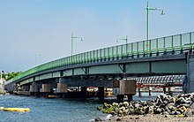
The Pelham Bridge is a bascule bridge located in the New York City borough of the Bronx, just downstream of the railroad Pelham Bay Bridge. It carries Shore Road and a walkway along the downstream side, over the Hutchinson River. The bridge is operated and maintained by the New York City Department of Transportation. Crossing the mouth of the river, it is variously called Pelham Bay Bridge and Pelham Bridge. The BL45 to/from Eastchester in Westchester County as well as the Bx29, which operates between City Island and Co-op City, operates over this bridge.
Cuban Ledge is a reef or islet composed chiefly of sand and small rocks in Eastchester Bay, the Bronx, in Long Island Sound. It is located between Rodman's Neck and Country Club in Eastchester Bay and is visible only during periods of low tide. It is a hazard to boats, and is marked with a signal tower.
Rodman's Neck refers to a peninsula of land in the New York City borough of the Bronx that juts out into Long Island Sound. The southern third of the peninsula is used as a firing range by the New York City Police Department; the remaining wooded section is part of Pelham Bay Park. The north side is joined to what used to be Hunters Island and Twin Island to form Orchard Beach and a parking lot.

The Hutchinson River, also known as Aqueanouncke in the Munsee language, is a 10 mile-long (16 km) freshwater stream located in the New York City borough of the Bronx and Southern Westchester County, New York, United States. It forms on the New Rochelle–Scarsdale municipal line off Brookline Road in the latter community and flows south, draining a 19.4-square-mile (50 km2) area. It continues to serve as New Rochelle's city line with Eastchester; further downstream; its lower reaches divide Mount Vernon and Pelham until it enters the Bronx and empties into Long Island Sound's Eastchester Bay.

Country Club is a residential neighborhood located in the East Bronx in New York City. The neighborhood's boundaries are Middletown Road and Watt Avenue to the north, Eastchester Bay to the east, Layton Avenue and the Throggs Neck neighborhood to the south, and the New England Thruway and Pelham Bay neighborhood to the west. Pelham Bay Park, the largest public park in New York City, is located just north of Country Club.

U.S. Route 1 (US 1) is a part of the U.S. Highway System that extends from Key West, Florida, to the Canada–United States border at Fort Kent, Maine. In the U.S. state of New York, US 1 extends 21.54 miles (34.67 km) from the George Washington Bridge in Manhattan to the Connecticut state line at Port Chester. It closely parallels Interstate 95 (I-95) for much of its course and does not serve as a major trunk road within the state. It is not concurrent with any other highways besides I-95 and (briefly) US 9, and few other state highways intersect it.

The East Bronx is the part of the New York City borough of the Bronx which lies east of the Bronx River; this roughly corresponds to the eastern half of the borough. Neighborhoods include: Baychester, Castle Hill, City Island, Co-op City, Country Club, Eastchester, Edenwald, Edgewater Park, Harding Park, Morris Park, Parkchester, Pelham Bay, Pelham Parkway, Soundview, Throggs Neck, Van Nest, Wakefield, Westchester Square, and Williamsbridge.

Victoria Harbour is a harbour, seaport, and seaplane airport in the Canadian city of Victoria, British Columbia. It serves as a cruise ship and ferry destination for tourists and visitors to the city and Vancouver Island. It is both a port of entry and an airport of entry for general aviation. Historically it was a shipbuilding and commercial fishing centre. While the Inner Harbour is fully within the City of Victoria, separating the city's downtown on its east side from the Victoria West neighbourhood, the Upper Harbour serves as the boundary between the City of Victoria and the district municipality of Esquimalt. The inner reaches are also bordered by the district of Saanich and the town of View Royal. Victoria is a federal "public harbour" as defined by Transport Canada. Several port facilities in the harbour are overseen and developed by the Greater Victoria Harbour Authority, however the harbour master's position is with Transport Canada.
Westchester Creek is a tidal inlet of the East River located in the south eastern portion of the Bronx in New York City. It is 2.1 miles (3.39 km) in length. The creek formerly traveled further inland, to what is now Pelham Parkway, extending almost to Eastchester Bay and making Throggs Neck into an island during heavy storms. However, much of the route has been filled in, replaced by such structures as the New York City Subway's Westchester Yard and the Hutchinson Metro Center. Westchester Creek's present-day head is at Herbert H. Lehman High School; the remaining portion is largely inaccessible and surrounded by industrial enterprises or empty lots. Westchester Creek is traversed by the Bruckner Interchange at about its midpoint.

The Pelham Bay Bridge, also known as the Amtrak Hutchinson River Bridge, is a two-track movable railroad bridge that carries the Northeast Corridor (NEC) over the Hutchinson River in the Bronx, New York, upstream from the vehicular/pedestrian Pelham Bridge. It is owned by Amtrak, which provides passenger service, and is used by CSX Transportation and the Providence & Worcester Railroad for freight traffic.
The Nativity of Our Blessed Lady is a Roman Catholic parish church under the authority of the Roman Catholic Archdiocese of New York, located at 1510 East 233rd Street and the corner of Secor Avenue, Bronx, New York in the Eastchester neighborhood of the northern Bronx. The church was designed by Don Shepherd, a designer and not an architect. The AIA Guide to New York City described it as "a minor work but one which calls attention to itself because of its location and the rusted steel crucifix that dominates the corner of the site."

From the start of railroading in America through the first half of the 20th century, New York City and Long Island were major areas for rail freight transportation. However, their relative isolation from the mainland United States has always posed problems for rail traffic. Numerous factors over the late 20th century have caused further declines in freight rail traffic. Efforts to reverse this trend are ongoing, but have been met with limited success.
Pelham Road, known as Shore Road within the Bronx, is a historic 4.1-mile (6.6 km) east-west arterial road that runs along the Long Island Sound shoreline from Pelham Bay Park in the Bronx through the southern Westchester County, New York communities of New Rochelle and Pelham Manor. The thoroughfare had its beginning as a Native American trail linking the important villages on Davenport Neck to those on Pelham Neck in Pelham. Between these points along the shore line there was an almost continuous chain of small Indian villages and camps. This waterfront area was especially advantageous, with many small coves in secure harbors and protected by adjacent islands and many small streams of water and abundant springs.