Related Research Articles
The French Frigate Shoals is the largest atoll in the Northwestern Hawaiian Islands. Its name commemorates French explorer Jean-François de La Pérouse, who nearly lost two frigates when attempting to navigate the shoals. It consists of a 20-mile (32 km) long crescent-shaped reef, twelve sandbars, and the 120-foot (37 m) high La Perouse Pinnacle, the only remnant of its volcanic origins. The total land area of the islets is 61.508 acres (24.891 ha). Total coral reef area of the shoals is over 232,000 acres (94,000 ha). Tern Island, with an area of 26.014 acres (10.527 ha), has a landing strip and permanent habitations for a small number of people. It is maintained as a field station in the Hawaiian Islands National Wildlife Refuge by the United States Fish and Wildlife Service. The French Frigate Shoals are about 487 nautical miles northwest of Honolulu.

The Pelham Islands are a group of islands in western Long Island Sound that belonged to Thomas Pell in the 17th century. The islands, and most of the surrounding area, were purchased from the Siwanoy Indians by Pell in 1654, creating Pelham Manor. This large tract of land would eventually become the present day Town & Village of Pelham and Pelham Manor, Town of Eastchester, and cities of New Rochelle and Mount Vernon in Westchester County, and the Pelham Bay and Eastchester neighborhoods of the Bronx in New York City.

Eastchester Bay is a sound between City Island and the mainland Bronx in New York City, New York. Technically, it is not a bay, since it is open to larger bodies of water at both ends. The northern end connects via a narrow channel to Pelham Bay. The Hutchinson River empties into Eastchester Bay near the northern end. The lower portion of the bay opens onto the East River, Little Neck Bay, and Long Island Sound. Eastchester Bay is designated an Essential Fish Habitat by the National Marine Fisheries Service.
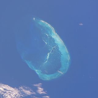
Saint Brandon, also known as the Cargados Carajos Shoals, is an Indian Ocean archipelago about 430 kilometres (270 mi) northeast of Mauritius consisting of a number of sand banks, shoals and islets. Saint Brandon consists of five island groups, with about 28–40 islands and islets in total, depending on seasonal storms and related sand movements. There are 22 named islands and shoals. The archipelago is low-lying and is prone to substantial submersion in severe weather. It has an aggregate land area estimated variously at 1.3 km2 (0.50 sq mi) and 500 acres (2.0 km2). Economic activity in the region is limited to fishing on the very extensive shallow bank covering approximately 900 sq mi (2,300 km2) around the islands. By the early 19th century, most of the islands were in use as fishing stations. Geographically, the archipelago is part of the Mascarene Islands and is situated on the Mascarene Plateau formed by the separation of the Mauritia microcontinent during the separation of India and Madagascar about 60 million years ago.

USCGC Mesquite (WAGL/WLB-305) was the lead ship in the Mesquite class of seagoing buoy tenders operated by the United States Coast Guard. She served in the Pacific during World War II, and spent the rest of her Coast Guard career in the Great Lakes. She ran aground and was wrecked in December 1989 off the Keweenaw Peninsula in Lake Superior. She was scuttled nearby as a recreational diving attraction.
Penfield Reef is a partially submerged reef that extends a mile into Long Island Sound from the coast of Fairfield, Connecticut. The reef is one of the most dangerous areas of Long Island Sound and continues to menace boaters despite the presence of the Penfield Reef Lighthouse. The area was a peninsula a few centuries ago, gradually worn down to a series of islands and eventually to a shoal. Sand and stones collected from the reef for use as ballast on ships contributed to the rapid erosion. Cows once grazed on the peninsula, and two of the groups of rocks were later named "Cows" and "Calves" in recognition of the early history. The reef is known as an ideal fishing spot for bluefish, flounder and striped bass. It was the site of the first civilian helicopter rescue.

SSMeteor is the sole surviving ship of the unconventional "whaleback" design. The design, created by Scottish captain Alexander McDougall, enabled her to carry a maximum amount of cargo with a minimum of draft. Meteor was built in 1896 in Superior, Wisconsin, United States, and, with a number of modifications, sailed until 1969. She is now a museum ship in the city of her birth.

Cay Sal Bank is the third largest and the westernmost of the Bahama Banks. It is located between 23º27'N - 24º10'N and 079º25'W – 080º35'W. In a geographical sense, it is separate from the Bahamas proper as it is much closer to Cuba than to the closest Bahamian island. It is separated by Santaren Channel from the Great Bahama Bank, the western rim of which is 50 km (31 mi) to the east. The Straits of Florida separate it from the United States mainland and the Florida Keys.

Cape Town lies at the south-western corner of the continent of Africa. It is bounded to the south and west by the Atlantic Ocean, and to the north and east by various other municipalities in the Western Cape province of South Africa.
Shark River Reef is an artificial reef located in the Atlantic Ocean, 15.6 miles southeast of Manasquan Inlet, off of the coast of Ocean County, New Jersey. The site contains almost 4 million cubic yards of dredge rock material. Although 96% of the total reef material is rock, the site also contains numerous subway cars.

SS Mataafa was an American steamship that had a lengthy career on the Great Lakes of North America, first as a bulk carrier and later as a car carrier. She was wrecked in 1905 in Lake Superior just outside the harbor at Duluth, Minnesota, during a storm that was named after her. She was built as SS Pennsylvania in 1899, and renamed Mataafa when she was purchased in the same year by the Minnesota Steamship Company. After her 1905 wreck, she was raised and repaired, and served for another sixty years before being scrapped.

Sevona was a steel-hulled lake freighter that sank in Lake Superior off the coast of Sand Island in Bayfield County, Wisconsin, United States. The wreckage site was added to the National Register of Historic Places in 1993.
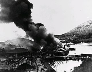
The SS Northwestern, originally SS Oriziba, was a passenger and freight steamship launched in 1889 by the Delaware River Iron Ship Building and Engine Works, Chester, Pennsylvania which spent most of its career in service in the waters of the Territory of Alaska. The ship from early in its career had a reputation for trouble, and was frequently involved in groundings, collisions with other ships, and with port facilities. She first served as a transport in the West Indies as Oriziba, and was acquired by the Northwestern Steamship Company in 1906, sailed around Cape Horn, and renamed Northwestern. For the next thirty years she worked along the Alaska coast, transporting people, mail, and goods, as well as ore from mining operations at Kennecott.

The Black Middens is a reef at the mouth of the River Tyne in North East England, noted for the danger it poses to shipping.

Royal Captain Shoal, also known as Kanduli Shoal ; Mandarin Chinese: 艦長礁/舰长礁; pinyin: Jiànzhǎng Jiāo; Vietnamese: Bãi Đồi Mồi, is a shoal in the South China Sea and a part of Spratly Islands. It is located in the vicinity of Northeast Investigator Shoal and Half Moon Shoal, at the eastern edge of the area named "Dangerous Ground".
References
- 1 2 3 Kalyanaraman (May 2003). "Clam Diggers and Mussel Suckers". Beyond Manhattan: New York's Other Islands. NYC24, Columbia University Graduate School of Journalism. Archived from the original on 2014-11-17.
- 1 2 3 4 Sharon Seitz, Stuart Miller (2011). The Other Islands of New York City: A History and Guide. The Countryman Press. p. 148. ISBN 9780881509458.
- 1 2 John McNamara (1978). History in Asphalt: The Origin of Bronx Street and Place Names. Bronx County Historical Society and Harbor Hill Books. p. 53. ISBN 978-0-916346-31-7.
| Major islands |  | |
|---|---|---|
| Pelham Islands | ||
| New York Bay | ||
| Jamaica Bay | ||
| East River | ||
| Other | ||
Former islands shown in italics | ||