The Bronx is a borough of New York City, coextensive with Bronx County, in the U.S. state of New York. It is south of Westchester County; north and east of the New York City borough of Manhattan, across the Harlem River; and north of the New York City borough of Queens, across the East River. The Bronx is the only New York City borough not primarily located on an island. The Bronx has a land area of 42 square miles (109 km2) and a population of 1,472,654 in the 2020 census. If each borough were ranked as a city, the Bronx would rank as the ninth-most-populous in the U.S. Of the five boroughs, it has the fourth-largest area, fourth-highest population, and third-highest population density. The population density of the Bronx was 32,718.7 inhabitants per square mile (12,632.8/km2) in 2022, the third-highest population density of any county in the United States, behind Manhattan and Brooklyn. With a population that is 54.8% Hispanic as of 2020, it is the only majority-Hispanic county in the Northeastern United States and the fourth-most-populous nationwide.

Westchester County is a county located in the U.S. state of New York. It is the seventh most populous county in the State of New York and the most populous north of New York City. According to the 2020 United States Census, the county had a population of 1,004,456, its highest decennial count ever and an increase of 55,344 (5.8%) from the 949,113 counted in 2010. Westchester covers an area of 450 square miles (1,200 km2), consisting of six cities, 19 towns, and 23 villages. Established in 1683, Westchester was named after the city of Chester, England. The county seat is the city of White Plains, while the most populous municipality in the county is the city of Yonkers, with 211,569 residents per the 2020 census. The county is part of the Hudson Valley region of the state.
Yonkers is the third-most populous city in the U.S. state of New York and the most-populous city in Westchester County. A centrally located municipality within the New York metropolitan area, Yonkers had a population of 211,569 at the 2020 United States census. Yonkers is classified as an inner suburb of New York City, immediately north of the Bronx and approximately 2.4 miles (4 km) north of Marble Hill.
The Bronx River Parkway is a 19.12-mile (30.77 km) limited-access parkway in downstate New York in the United States. It is named for the nearby Bronx River, which it parallels. The southern terminus of the parkway is at Story Avenue near the Bruckner Expressway in the Bronx neighborhood of Soundview. The northern terminus is at Kensico Circle in North Castle, Westchester County, where the parkway connects to the Taconic State Parkway and via a short connector, New York State Route 22 (NY 22). Within the Bronx, the parkway is maintained by the New York State Department of Transportation and is designated New York State Route 907H (NY 907H), an unsigned reference route. In Westchester County, the parkway is maintained by the Westchester County Department of Public Works and is designated unsigned County Route 9987 (CR 9987).

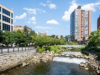
The Bronx River, is a river that is approximately 24 miles (39 km) long, and flows through southeastern New York in the United States and drains an area of 38.4 square miles (99 km2). It is named after colonial settler Jonas Bronck.

Spuyten Duyvil Creek is a short tidal estuary in New York City connecting the Hudson River to the Harlem River Ship Canal and then on to the Harlem River. The confluence of the three water bodies separate the island of Manhattan from the Bronx and the rest of the mainland. Once a distinct, turbulent waterway between the Hudson and Harlem rivers, the creek has been subsumed by the modern ship canal.

The Westchester County Bee-Line System, branded on the buses in lowercase as the bee-line system, is a bus system serving Westchester County, New York. The system is owned by the county's Department of Public Works and Transportation.
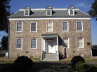
The Van Cortlandt House, also known as the Van Cortlandt Mansion, is the oldest known surviving house in the Bronx in New York City. It is located in the southwestern portion of Van Cortlandt Park. The house is operated as a historic house museum known as the Van Cortlandt House Museum. Built by Frederick Van Cortlandt and completed in 1749, the house is a 2+1⁄2-story Georgian building with a rubblestone facade and Georgian-style interiors. It served as a residence of one branch of the Van Cortlandt family for 140 years before it reopened as a museum in 1897.
The New York and Putnam Railroad, nicknamed the Old Put, was a railroad line that operated between the Bronx and Brewster in New York State. It was in close proximity to the Hudson River Railroad and New York and Harlem Railroad. All three came under ownership of the New York Central system in 1894. The railroad was abandoned starting in 1958, and most of the former roadbed has been converted to rail trail use.

The Saw Mill River Parkway is a limited-access parkway that extends for 28.93 miles (46.56 km) through Westchester County, New York, in the United States. It begins at the border between Westchester County and the Bronx, as the continuation of the Henry Hudson Parkway leaving New York City, and heads generally northeastward to an interchange with Interstate 684 (I-684). At its north end, the parkway serves as a collector/distributor road as it passes east of the hamlet of Katonah. The parkway is named for the Saw Mill River, which the highway parallels for most of its length.

Getty Square is the name for downtown Yonkers, New York, centered on the public square. Getty Square is the civic center, central business district, and transit hub of the City of Yonkers. A dense and growing residential area, it is located in southern Westchester County, New York. The square is named after prominent 19th-century merchant Robert Getty.
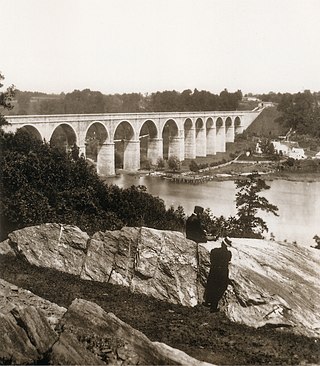
The Croton Aqueduct or Old Croton Aqueduct was a large and complex water distribution system constructed for New York City between 1837 and 1842. The great aqueducts, which were among the first in the United States, carried water by gravity 41 miles (66 km) from the Croton River in Westchester County to reservoirs in Manhattan. It was built because local water resources had become polluted and inadequate for the growing population of the city. Although the aqueduct was largely superseded by the New Croton Aqueduct, which was built in 1890, the Old Croton Aqueduct remained in service until 1955.

Van Cortlandt Park is a 1,146-acre (464 ha) park located in the borough of the Bronx in New York City. Owned by the New York City Department of Parks and Recreation, it is managed with assistance from the Van Cortlandt Park Alliance. The park, the city's third-largest, was named for the Van Cortlandt family, which was prominent in the area during the Dutch and English colonial periods.
Colen Donck was a 24,000 acre (97 km2) patroonship in New Netherland along the southern Hudson River in today's Bronx and Yonkers established by Dutch-American lawyer and land developer Adriaen van der Donck.

Mosholu Parkway is a 3.03-mile-long (4.88 km) parkway in the borough of the Bronx in New York City, constructed from 1935 to 1937 as part of the roadway network created under Robert Moses. The roadway extends between the New York Botanical Garden and Van Cortlandt Park. The New York City Department of Transportation is responsible for the operation and maintenance of the roadway while the New York City Department of Parks and Recreation is responsible for the surrounding rights-of-way. The parkway is designated as New York State Route 908F (NY 908F), an unsigned reference route, by the New York State Department of Transportation.

The Saw Mill River is a 23.5-mile (37.8 km) tributary of the Hudson River in Westchester County, New York, United States. It flows from an unnamed pond north of Chappaqua to Getty Square in Yonkers, where it empties into the Hudson as that river's southernmost tributary. It is the only major stream in southern Westchester County to drain into the Hudson instead of Long Island Sound. It drains an area of 26.5 square miles (69 km2), most of it heavily developed suburbia. For 16 miles (26 km), it flows parallel to the Saw Mill River Parkway, a commuter artery, an association that has been said to give the river an "identity crisis."
The West Bronx is a region in the New York City borough of the Bronx. The region lies west of the Bronx River and roughly corresponds to the western half of the borough.

The South County Trailway is a 14.1-mile (22.7 km) long rail trail stretching from the Putnam Trail in Van Cortlandt Park in the Bronx to the North County Trailway in East View, New York. Westchester County Parks constructed the trailway in segments beginning in 1990 and completed it on October 31, 2017.

New York State Route 164 (NY 164) was a state highway in the New York City Metropolitan Area. It extended for 5 miles (8 km) from U.S. Route 9 (US 9) and NY 9A in Yonkers to US 1 in the New York City borough of the Bronx. The route ran mostly along the New York City line and indirectly met both the Saw Mill River Parkway and the New York State Thruway in Yonkers. NY 164 followed McLean Avenue in Yonkers and Nereid and Baychester Avenues in the Bronx.

Tibbetts Brook Park is a 161-acre (65 ha) park located in the Lincoln Park section of Yonkers in Westchester County, New York. Opened in 1927, it was one of the first developed parks in Westchester County and is accessible only to County residents, with activities that include swimming, hiking, sports, nature watching and fishing.