Kissena Creek

Last updated

An 1873 map of Queens showing the route of Kissena Creek (blue) and the Central Railroad. 1873 Beers Map of Flushing and College Point, Queens, New York - Geographicus - Kissena Creek & Central RR 2A.jpg
An 1873 map of Queens showing the route of Kissena Creek (blue) and the Central Railroad.

Kissena Creek (also Mill Creek or Ireland Mill Creek) is a buried stream located in the neighborhoods of Flushing, Fresh Meadows, Hillcrest, and Kew Gardens Hills in the New York City borough of Queens. Kissena Creek originates in a now-filled swamp within Kew Gardens Hills and Pomonok in central Queens, flowing east to Hillcrest. The creek then travels mostly north and west, largely flowing beneath Kissena Park Golf Course, Kissena Park, Kissena Corridor Park, and Queens Botanical Garden, before merging with the Flushing River in Flushing Meadows–Corona Park. [1]

Contents

The name "Kissena" comes from the Chippewa language term for "it is cold", "cold place", or "cool water". Much of the creek was covered or diverted into sewers in the 20th century, and the only extant above-ground portion of the creek is Kissena Lake in Kissena Park.

Headwaters

The creek, also known historically as Mill Creek or Ireland Mill Creek, [2] [3] begins at what was formerly a swamp in the modern Kew Gardens Hills and Pomonok areas. [2] [4] The swamp was variously known as "Peat Bog Swamp", "Old Crow Swamp", "Doughty's Swamp", and "Gutman's Swamp". [5] [6] [7] The 140-acre (57 ha) swamp [2] [4] [6] was bound by Vleigh Place near Main Street to its west, and Kissena Boulevard and Parsons Boulevard to the east. [2] [4] When Parsons and Kissena Boulevards were laid out as the combined "Jamaica and Flushing Road", [8] the route curved around the north edge of the swamp. [2] [4] [9] The curve later became known as "Dead Man's Bend", due to the frequent accidents that would appear there, until a bypass was made by extending Kissena Boulevard southeast to Parsons Boulevard. [9] The original alignment between Kissena and Parsons Boulevards remains as the two-block Aguilar Avenue. [2] [10] [4]

In the late 19th century, the swamp served as a source for peat, a fossil fuel related to coal that forms from decayed plant matter. As Kew Gardens Hills gradually developed, the swamp shrunk in size with the street grid resting on top of it. The swamp was completely drained by 1918, except for a small section under a barn, whose owner had bought the barn from the city government and moved it to the swamp's "easement area". [11] The last remaining section of the swamp, covering 23 acres (9.3 ha), remained undeveloped through the end of the 20th century. [6] Lander College for Men was built on the site in 2000, [6] while Opal Apartments was developed in 2004. [2] [6] [12]

Fresh Meadows

Past the swamp, the creek travels east parallel to 72nd Avenue. [2] [13] It turns north in modern Fresh Meadows, at the site of Francis Lewis High School, then travels parallel to today's Utopia Parkway to the modern Kissena Park Golf Course, just south of Flushing Cemetery. [14] [3] [15] The creek runs under Fresh Meadow Lane, which forms the Kissena Park Golf Course's eastern border, and then turns westward underneath the golf course's northern border. [16]

A tributary flowed northward from a kettle pond in present-day Utopia Playground and merged with the main creek at Utopia Parkway. [14] [10] The pond was located at the junction of Fresh Meadow Lane and 73rd Avenue, which was known as Black Stump Road. This road took its name from a local landmark along current Fresh Meadows Lane: the remnants of a large tree that had burned after being struck by lightning, and that was known as the "Black Stump". [14] [17] The kettle pond was infilled in 1941. [14] [10]

Kissena Park

Kissena Lake Kissena Park pond.jpg
Kissena Lake

The creek then turns west and flows into Kissena Lake. [16] [3] Located at the northwestern corner of Kissena Park, Kissena Lake is fed by the creek and was also fed by a smaller stream from the north that has since been buried with a playground built on top. [16] In its center is a bird sanctuary isle constructed following the lake's most recent restoration in 2003. [18] The name of the lake, park, and creek comes from the Chippewa language meaning "it is cold", "cold place", or "cool water". [19] [20]

The site of Flushing Meadows–Corona Park, slightly west of Kissena Park, was originally part of the ancestral path of the Hudson River, and the present-day Kissena Lake was located on the eastern shore of the river. [21] [22] A glacier covered much of Long Island, where Queens is located, and formed a terminal moraine through the center of the island. When the glacier receded, it created several recesses in the land; some of these recesses, such as Kissena Lake, were filled with water. [23] [24] The lake was used as an ice skating and ice harvesting site for much of the 19th century. Its use as a recreational site led the city to purchase land around it for a park in 1906. [25] The glaciation also created a natural source of well water for the area. [23]

Originally, the western end of Kissena Lake drained into the creek and was traversed by a bridge, similar to Central Park's Gapstow Bridge. [26] Kissena Lake was dredged in 1942 as part of a Works Progress Administration initiative. This transformed Kissena Lake into a "bathtub lake" with a concrete shoreline. [26] [27] [19] Prior to the renovation, Kissena Lake was part of a wetland, which was believed to be a worthless type of land during the 20th century. [28] Lacking natural aeration and warmed by its shallower depth and concrete shoreline, the lake suffered a buildup of algae. This necessitated another restoration project, which was undertaken in 1983. [26] [27] In 2003, a $2.3 million restoration drained the lake in stages, resulting in its current appearance. The city water was replaced with well water, an aeration system was installed, the concrete bulkheads were replaced with natural-looking materials such as rocks and plants, and a small island for birds and turtles was built within the lake. [26] [18]

Kissena Corridor Park

Located underneath Kissena Park and the western portion of Kissena Corridor Park is the Kissena Corridor Sewer. The combined sewer receives water from as far east as Little Neck, near New York City's border with Nassau County. [27] [29] [30] It was adapted from the path of Kissena Creek, which had been gradually diverted into the sewer during the mid-20th century. [31] In 1934, the creek was placed in a culvert at its crossing with Main Street (then called Jagger Avenue), as part of a widening project for the street. [3]

The Kissena Corridor project was initiated in the 1930s as a greenbelt to link several parks in eastern Queens. It included the construction of a major storm sewer through the corridor, [32] [33] which the Parks Department said was necessitated as a result of "the great extent of this natural drainage basin." [33] In 1942, the federal War Production Board barred the construction of the Corridor Sewer, due to steel requirements for the World War II effort. [34] Groundbreaking ceremonies for the sewer project were held on April 1, 1947, at the intersection of Lawrence Street and Fowler and Blossom Avenues, near the modern-day Queens Botanical Garden west of Kissena Park. [35] On February 19, 1948, the final contract for the project, including the trunk line from 188th Street to Francis Lewis Boulevard, was authorized from the Board of Estimate. [36] Eight days later, the Queens borough sewer engineer announced that the cost of the sewer project would run to over $10,000,000, $2.25 million higher than the previous figure. [37] The main trunk of the Corridor Sewer was completed by September 1948, although many of the feeder lines had yet to be constructed. [38]

The western stretch of Kissena Corridor Park was landfilled in the 1950s from dirt excavated for the construction of the Long Island Expressway. [39] [40] [41] Prior to the filling operations, the creek was still visible within the western portion of the park, and occasionally caused flooding in the surrounding neighborhoods. [39] By 1960, about 550,000 cubic yards (420,000 m3) of dirt were deposited on the park from the Long Island Expressway. [41] Additionally, in 1959, New York City parks commissioner Robert Moses had announced that more fill would come from the Clearview Expressway, which would raise the grade of the park and end garbage landfilling. [41] [42]

Queens Botanical Garden

The sewers from Kissena Corridor Park flow west through the Queens Botanical Garden. [43] From there, the sewers cross College Point Boulevard and enter the Flushing Bay Combined Sewer Outfall (CSO) Retention Facility, located in Flushing Meadows underneath the Al Oerter Recreation Center. The facility can hold up to 43.4 million US gallons (164 Ml) of water from overflows during storms, before pumping the water to the Tallman Island Waste Water Treatment Plant in College Point. [43] [29] [44] Otherwise, the water empties into the Flushing River (also known as Flushing Creek). [43] The Flushing River flows north into Flushing Bay, part of the East River, which in turn is an arm of the Atlantic Ocean. Formerly, Kissena Creek flowed from the Botanical Garden site directly into Flushing Meadows, merging with the Flushing River near the site of the present-day Fountain of the Planets. [43] [3]

Prior to the 1964−1965 New York World's Fair, the western portion of Kissena Corridor Park between Lawrence Street/College Point Boulevard and Main Street adjacent to Flushing Meadows Park was leased to the World's Fair Corporation, along with most of Flushing Meadows. [45] In 1961, as part of $3 million in development for the World's Fair, the Queens Botanical Garden was planned to be relocated from the fair grounds in Flushing Meadows to the west end of Kissena Corridor Park adjacent to the World's Fair Grounds. [46] [47] [48] [49] This site was originally planned to be used as parking space for the fair. [50] Instead, the Queens Botanical Garden was built, and it was dedicated on October 19, 1963. [51] [52]

The QBG's 2001 Master Plan included the construction of a self-sustaining ecosystem. The plan consisted of a stream forming from rainwater collected atop the roof of its administration building, flowing through pools towards a wetland at the garden's western edge. Runoff collected in the garden's parking lot and other locations would also contribute to the stream. Part of the stream follows the path of Kissena Creek. [3]

Related Research Articles

<span class="mw-page-title-main">Flushing Meadows–Corona Park</span> Public park in Queens, New York

Flushing Meadows–Corona Park, often referred to as Flushing Meadows Park, or simply Flushing Meadows, is a public park in the northern part of Queens in New York City, New York, U.S. It is bounded by I-678 on the east, Grand Central Parkway on the west, Flushing Bay on the north, and Union Turnpike on the south. Flushing Meadows–Corona Park is the fourth-largest public park in New York City, with a total area of 897 acres (363 ha).

<span class="mw-page-title-main">Flushing, Queens</span> Neighborhood of northern Queens in New York City

Flushing is a neighborhood in the north-central portion of the New York City borough of Queens. The neighborhood is the fourth-largest central business district in New York City. Downtown Flushing is a major commercial and retail area, and the intersection of Main Street and Roosevelt Avenue at its core is the third-busiest in New York City, behind Times Square and Herald Square.

<span class="mw-page-title-main">Flushing–Main Street station (IRT Flushing Line)</span> New York City Subway station in Queens

The Flushing–Main Street station is the eastern terminal on the IRT Flushing Line of the New York City Subway, located at Main Street and Roosevelt Avenue in Downtown Flushing, Queens. It is served by the 7 local train at all times and the <7> express train during rush hours in the peak direction.

<span class="mw-page-title-main">Newtown Creek</span> Tributary of the East River in New York City

Newtown Creek, a 3.5-mile (6-kilometer) long tributary of the East River, is an estuary that forms part of the border between the boroughs of Brooklyn and Queens, in New York City. Channelization made it one of the most heavily-used bodies of water in the Port of New York and New Jersey and thus one of the most polluted industrial sites in the United States, containing years of discarded toxins, an estimated 30,000,000 US gallons of spilled oil, including the Greenpoint oil spill, raw sewage from New York City's sewer system, and other accumulation from a total of 1,491 sites.

<span class="mw-page-title-main">Fresh Meadows, Queens</span> Neighborhood of Queens in New York City

Fresh Meadows is a neighborhood in the northeastern section of the New York City borough of Queens. Fresh Meadows used to be part of the broader town of Flushing and is bordered to the north by the Horace Harding Expressway and Auburndale; to the west by Pomonok, St. John's University, Hillcrest, and Utopia; to the east by Cunningham Park and the Clearview Expressway; and to the south by the Grand Central Parkway.

<span class="mw-page-title-main">Queens Botanical Garden</span> Botanical garden in New York City

Queens Botanical Garden is a botanical garden located at 43-50 Main Street in Flushing, Queens, New York City. The 39-acre (16 ha) site features rose, bee, herb, wedding, and perennial gardens; an arboretum; an art gallery; and a LEED-certified Visitor & Administration Building. Queens Botanical Garden is located on property owned by the City of New York, and is funded from several public and private sources. It is operated by Queens Botanical Garden Society, Inc.

<span class="mw-page-title-main">Kew Gardens Hills, Queens</span> Neighborhood in Queens, New York City

Kew Gardens Hills is a neighborhood in the middle of the New York City borough of Queens. The borders are Flushing Meadows-Corona Park to the west, the Long Island Expressway to the north, Union Turnpike to the south, and Parsons Boulevard to the east.

<span class="mw-page-title-main">Kissena Park</span> Public park in Queens, New York

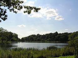
Kissena Park is a 235-acre (95 ha) park located in the neighborhood of Flushing in Queens, New York City. It is located along the subterranean Kissena Creek, which flows into the Flushing River. It is bordered on the west by Kissena Boulevard; on the north by Rose, Oak, Underhill, and Lithonia Avenues; on the east by Fresh Meadow Lane; and on the south by Booth Memorial Avenue. The park contains the city's only remaining velodrome, a lake of the same name, two war memorials, and various playgrounds and sports fields.

<span class="mw-page-title-main">Alley Pond Park</span> Public park in Queens, New York

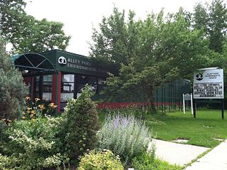
Alley Pond Park is the second-largest public park in Queens, New York City, occupying 655.3 acres (265.2 ha). The park is bordered to the east by Douglaston, to the west by Bayside, to the north by Little Neck Bay, and to the south by Union Turnpike. The Cross Island Parkway travels north-south through the park, while the Long Island Expressway and Grand Central Parkway travel east-west through the park. The park primarily consists of woodlands south of the Long Island Expressway and meadowlands north of the expressway. It is run and operated by the New York City Department of Parks and Recreation.

<span class="mw-page-title-main">Flushing River</span> Creek in Queens, New York

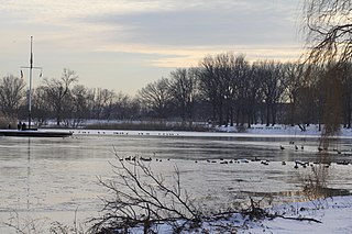
The Flushing River, also known as Flushing Creek, is a waterway that flows northward through the borough of Queens in New York City, mostly within Flushing Meadows–Corona Park, emptying into the Flushing Bay and the East River. The river runs through a valley that may have been a larger riverbed before the last Ice Age, and it divides Queens into western and eastern halves. Until the 20th century, the Flushing Creek was fed by three tributaries: Mill Creek and Kissena Creek on the eastern bank, and Horse Brook on the western bank.

<span class="mw-page-title-main">Q17 (New York City bus)</span> Bus route in Queens, New York

The Q17 bus route constitutes a public transit line in Queens, New York City, running primarily along Kissena Boulevard, the Long Island Expressway service road and 188th Street between two major bus-subway hubs in the neighborhoods of Jamaica and Flushing. It is one of the busiest local bus routes in Queens. Operated by the North Shore Bus Company until 1947, the route is now operated by MTA Regional Bus Operations under the New York City Transit brand.

The Q74 bus route constituted a public transit line in Queens, New York City. It ran primarily along Main Street, Vleigh Place, and Union Turnpike between Queens College and the Kew Gardens–Union Turnpike subway station. Operated by the North Shore Bus Company from the 1930s to March 1947, the route was later city operated by MTA Regional Bus Operations under the New York City Transit brand until June 27, 2010, when it was discontinued under system-wide service cuts.

The North Shore Bus Company operated public buses in Queens, New York City. It was established in 1920 as the successor to the New York and North Shore Traction Company trolley system, and operated until 1947 when it went bankrupt, and its operations were taken over by the New York City Board of Transportation.

The Brooklyn–Queens Greenway is a bicycling and pedestrian path connecting parks and roads in the New York City boroughs of Brooklyn and Queens, connecting Coney Island in the south to Fort Totten in the north, on Long Island Sound. The route connects major sites in the two boroughs, such as the New York Aquarium, Brooklyn Museum, the Brooklyn Botanic Garden, the New York Hall of Science, and Citi Field.

<span class="mw-page-title-main">Main Street (Queens)</span> Street in Queens, New York

Main Street is a major north–south street in the borough of Queens in New York City, extending from Queens Boulevard in Briarwood to Northern Boulevard in Flushing. Created in the 17th century as one of Flushing's main roads, Main Street has been lengthened at various points in its existence.

<span class="mw-page-title-main">Baisley Pond Park</span> Public park in Queens, New York

Baisley Pond Park is a public park located in the southeastern part of Queens, New York City, bordering the neighborhoods of South Jamaica, Rochdale, and St. Albans. It covers 109.61 acres (44.36 ha), including the 30-acre (12 ha) Baisley Pond in the center of the park. It is maintained by the New York City Department of Parks and Recreation.

<span class="mw-page-title-main">Q65 (New York City bus)</span> Bus route in Queens, New York

The Q65 bus route constitutes a public transit line in Queens, New York City. The south-to-north route runs primarily on 164th Street, operating between two major bus-subway hubs: Sutphin Boulevard–Archer Avenue station in Jamaica and Flushing–Main Street station in Flushing. It then extends north along College Point Boulevard to College Point at the north end of the borough. The route is city-operated under the MTA Bus Company brand of MTA Regional Bus Operations.

<span class="mw-page-title-main">Q20 and Q44 buses</span> Bus routes in Queens and the Bronx, New York

The Q20A and Q20B and Q44 bus routes constitute the Main Street Line, a public transit line in Queens, New York City, running primarily along Main Street between two major bus-subway hubs in the neighborhoods of Jamaica and Flushing. The Q20A/B terminates in College Point at the north end of Queens. The Q44 continues north into the borough of the Bronx, terminating in the West Farms neighborhood near the Bronx Zoo. The Q44 is one of two Queens bus routes to operate between the two boroughs.

<span class="mw-page-title-main">Q64, QM4 and QM44 buses</span> Bus routes in Queens, New York

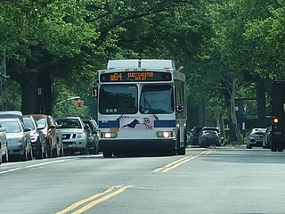
The Q64, QM4 and QM44 bus routes constitute a public transit line in Queens, New York City. The east-to-west Q64 route runs primarily on Jewel Avenue operating between the Forest Hills–71st Avenue subway station in Forest Hills and 164th Street in Electchester. The QM4 route is an express bus route running from Midtown Manhattan to Electchester running via Sixth Avenue in Manhattan and Jewel Avenue in Queens. The QM44 route is an express bus route running from Midtown Manhattan to Electchester via Third Avenue in Manhattan and Jewel Avenue in Queens.

<span class="mw-page-title-main">Spring Creek Park</span> Public park in New York City

Spring Creek Park is a public park along the Jamaica Bay shoreline between the neighborhoods of Howard Beach, Queens, and Spring Creek, Brooklyn, in New York City. Created on landfilled former marshland, the park is mostly an undeveloped nature preserve, with only small portions accessible to the public for recreation.

References

  1. Kadinsky 2016, pp. 109–116.
  2. 1 2 3 4 5 6 7 8 Kadinsky 2016, p. 109.
  3. 1 2 3 4 5 6 "Queens Botanical Garden Master Plan" (PDF). Queens Botanical Garden, Conservation Design Forum, Atelier Dreiseitl. 2002. pp. 96–101. Archived (PDF) from the original on February 3, 2019. Retrieved May 31, 2018.
  4. 1 2 3 4 5 Kadinsky, Sergey (January 3, 2018). "Likely Namesake Of KGH's Aguilar Avenue? An English Jewish Poetess". Queens Jewish Link. Archived from the original on June 17, 2018. Retrieved July 6, 2018.
  5. "Start Drainage of 'Old Crow Swamp,' 3rd Ward Menace" (PDF). Brooklyn Daily Star. June 14, 1918. p. 2. Retrieved July 7, 2018 via Fultonhistory.com.
  6. 1 2 3 4 5 Lasky, Julie (March 7, 2018). "Kew Gardens Hills: A Little Town in Central Queens". The New York Times. ISSN   0362-4331. Archived from the original on January 26, 2020. Retrieved January 9, 2020.
  7. New York (State) (1809). Laws of the State of New York. p. 149. Archived from the original on October 26, 2023. Retrieved March 2, 2020.
  8. La Guardia International Airport and John F. Kennedy International Airport, Port Authority of New York and New Jersey Airport Access Program, Automated Guideway Transit System (NY, NJ): Environmental Impact Statement. Port Authority of New York and New Jersey, United States Department of Transportation, Federal Aviation Administration, New York State Department of Transportation. June 1994. Archived from the original on October 26, 2023. Retrieved July 23, 2016.
  9. 1 2 "Roadway Hazard To Be Eliminated: Kink in Jamaica Line to Be Straightened" (PDF). North Shore Daily Journal. June 24, 1938. p. 5. Retrieved July 6, 2018 via Fultonhistory.com.
  10. 1 2 3 "Utopia Playground : NYC Parks". New York City Department of Parks and Recreation. Archived from the original on October 26, 2023. Retrieved November 25, 2013.
  11. "Gutman's Swamp Drained". Brooklyn Daily Eagle. June 16, 1918. p. 44. Archived from the original on October 26, 2023. Retrieved January 9, 2020 via Brooklyn Public Library; newspapers.com.
  12. Yaniv, Oren (November 21, 2004). "New Opal's a real gem Kew Gardens gets luxury apartments". New York Daily News. Archived from the original on October 9, 2020. Retrieved January 9, 2020.
  13. Herbert, Lionel (April 13, 1933). "200-Year-Old Flushing-Hillcrest House Links Motor Age With Colonial Days" (PDF). Greenpoint Daily Star. p. 18. Retrieved July 7, 2018 via Fultonhistory.com.
  14. 1 2 3 4 Kadinsky 2016, p. 110.
  15. "Flushing Creek Bridge to Open: Big Celebration Planned for Tomorrow, When New $400,000 Span Is Commissioned; To Commemorate City' Gaining Kissena Park; Seventy-Five Acre Tract, Including Lake, Acquired and Prominent Officials Will Dedicate It" (PDF). New York Evening Telegram . October 16, 1906. p. 15. Retrieved June 2, 2018 via Fultonhistory.com.
  16. 1 2 3 Kadinsky 2016, p. 111.
  17. Beyer, Gregory (June 19, 2009). "An Outpost of the City, Within the City" . The New York Times. ISSN   0362-4331. Archived from the original on February 23, 2012. Retrieved August 29, 2009.
  18. 1 2 "Kissena Lake Project Ahead Of Schedule In Flushing Park". Queens Chronicle. Archived from the original on October 26, 2023. Retrieved January 9, 2020.
  19. 1 2 "Kissena Park". New York City Department of Parks and Recreation. Archived from the original on May 7, 2018. Retrieved June 2, 2018.
  20. "Kissena Lake Received Its Name By Being Cold" (PDF). North Shore Daily Journal. March 5, 1934. p. 12. Retrieved June 2, 2018 via Fultonhistory.com.
  21. "Queens Botanical Garden Master Plan" (PDF). Queens Botanical Garden, Conservation Design Forum, Atelier Dreiseitl. 2002. Archived (PDF) from the original on February 3, 2019. Retrieved May 31, 2018.
  22. Feller 1988, p. 2.
  23. 1 2 Feller 1988, pp. 1–3.
  24. "Kissena Lake Site for Proposed Park; Valuable Source of Pure Water Supply That Should Be Secured by City". Brooklyn Daily Eagle . Flushing, Queens. May 15, 1904. p. 46. Archived from the original on February 4, 2019. Retrieved July 7, 2018 via Newspapers.com.
  25. "Kissena Park Map : NYC Parks". NYC.gov. The City of New York. Archived from the original on December 9, 2013. Retrieved July 25, 2013.
  26. 1 2 3 4 Kadinsky 2016, p. 113.
  27. 1 2 3 Natural Resources Group. "Natural Area Mapping and Inventory of Kissena Park November 1986 Survey" (PDF). New York City Parks Department. p. 2. Archived (PDF) from the original on February 3, 2018. Retrieved June 2, 2018.
  28. Feller 1988, p. 6.
  29. 1 2 "Combined Sewer Overflow Long Term Control Plan for Alley Creek and Little Neck Bay" (PDF). New York City Department of Environmental Protection, AECOM USA, Inc. November 2013. pp. 2–12, 2-15 to 2-18. Archived (PDF) from the original on November 1, 2019. Retrieved June 4, 2018.
  30. Flushing Bay Report, pp. 3-18 to 3-19, 3-23 to 3-25, 1-1 to 1-2 (PDF pp. 77−78, 82−84, 401−402).
  31. Kadinsky 2016, p. 112.
  32. "Moses Backs Corridor to Link Parks: Approves Harvey Plan for Kissena – Flushing Meadow Strip" (PDF). Long Island Daily Press. August 19, 1940. Retrieved May 28, 2018 via Fultonhistory.com.
  33. 1 2 "For Release: Monday, August 19, 1940" (PDF). New York City Department of Parks and Recreation . August 19, 1940. Archived (PDF) from the original on February 17, 2017. Retrieved May 29, 2018.
  34. "WPB Rules Out Park Corridor Sewer Project: Home Owners Are Told They'll Have to Wait Till After War" (PDF). Long Island Star-Journal. August 10, 1942. p. 3. Retrieved May 31, 2018 via Fultonhistory.com.
  35. See:
  36. "Final Contract Ordered For Corridor Sewer" (PDF). Long Island Star-Journal. February 20, 1948. p. 1. Retrieved May 31, 2018 via Fultonhistory.com.
  37. "Corridor Sewer Cost Upped by $2,250,000" (PDF). Long Island Star-Journal. February 28, 1948. p. 1. Retrieved May 31, 2018 via Fultonhistory.com.
  38. See:
  39. 1 2 Kadinsky 2016, p. 114.
  40. See:
  41. 1 2 3 ""Why," Asked as Project Lags" (PDF). Long Island Star-Journal. January 11, 1960. p. 24. Retrieved May 28, 2018 via Fultonhistory.com.
  42. "Dirt From Expressway To Fill Corridor Park" (PDF). Long Island Star-Journal. June 8, 1959. p. 3. Retrieved June 6, 2018 via Fultonhistory.com.
  43. 1 2 3 4 Kadinsky 2016, p. 115.
  44. Flushing Bay Report, pp. 1-1 to 1-2 (PDF pp. 401−402).
  45. City of New York 1960, p. 3.
  46. City of New York 1960, pp. 10–13.
  47. "Mova Botanical Gardens" (PDF). Bayside Times. November 9, 1961. p. 2. Retrieved May 30, 2018 via Fultonhistory.com.
  48. "City Ponders Funds for World's Fair" (PDF). Long Island Star-Journal. November 22, 1961. p. 35. Retrieved May 31, 2018 via Fultonhistory.com.
  49. "Garden Bill Given Push; By City Council" (PDF). Long Island Star-Journal. March 10, 1961. p. 5. Retrieved May 31, 2018 via Fultonhistory.com.
  50. "World's Fair Parking Plan Hit: Setup Branded as 'Frightening' to Neighborhood" (PDF). Long Island Star-Journal. April 19, 1960. p. 5. Retrieved June 4, 2018 via Fultonhistory.com.
  51. "To Be Dedicated" (PDF). Long Island Star-Journal. October 18, 1963. p. 8. Retrieved May 31, 2018 via Fultonhistory.com.
  52. 30 Years of Progress: 1934–1965 (PDF). New York City Department of Parks and Recreation. June 9, 1964. p. 42. Archived (PDF) from the original on October 9, 2022. Retrieved March 31, 2017.

Sources

40°44′59″N73°49′33″W / 40.74972°N 73.82583°W / 40.74972; -73.82583