
Jamaica Bay Wildlife Refuge is a wildlife refuge in New York City managed by the National Park Service as part of Gateway National Recreation Area. It is composed of the open water and intertidal salt marshes of Jamaica Bay. It lies entirely within the boundaries of New York City, divided between the boroughs of Brooklyn to the west and Queens to the east.

Woodhaven is a neighborhood in the southwestern section of the New York City borough of Queens. It is bordered on the north by Park Lane South and Forest Park, on the east by Richmond Hill, on the south by Ozone Park and Atlantic Avenue, and the west by the Cypress Hills neighborhood of Brooklyn.

Glendale is a neighborhood in the west-central portion of the New York City borough of Queens. It is bounded by Forest Hills to the east, Ridgewood to the west, Woodhaven to the south, and Middle Village to the north.

Richmond Hill is a commercial and residential neighborhood located in the southeastern section of the New York City borough of Queens. The area borders Kew Gardens and Forest Park to the north, Jamaica and South Jamaica to the east, South Ozone Park to the south, and Woodhaven and Ozone Park to the west. The neighborhood is split between Queens Community Board 9 and 10.

LeFrak City is a 4,605-apartment development in the southernmost region of Corona and the easternmost part of Elmhurst, a neighborhood in the New York City borough of Queens. It is located between Junction Boulevard to the west, 57th Avenue to the north, 99th Street to the east, and the Long Island Expressway to the south.
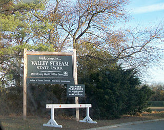
Valley Stream State Park is a 97-acre (0.39 km2) state park located in the village of Valley Stream in Nassau County, New York. The park is one of three state parks located in the Town of Hempstead on Long Island. Like Hempstead Lake State Park, Valley Stream State Park contained Cornell's Pond, a feeder reservoir for the Ridgewood Reservoir.

Forest Park is a park in the New York City borough of Queens, spanning 538 acres (218 ha). It is the tenth-largest park in New York City and the third-largest in Queens. Created on August 9, 1895, it was originally referred to as Brooklyn Forest Park, as the area was part of Brooklyn at the time.
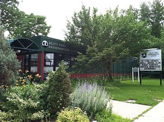
Alley Pond Park is the second-largest public park in Queens, New York City, occupying 655.3 acres (265.2 ha). The park is bordered to the east by Douglaston, to the west by Bayside, to the north by Little Neck Bay, and to the south by Union Turnpike. The Cross Island Parkway travels north-south through the park, while the Long Island Expressway and Grand Central Parkway travel east-west through the park. The park primarily consists of woodlands south of the Long Island Expressway and meadowlands north of the expressway. It is run and operated by the New York City Department of Parks and Recreation.

Hammels is an area within Rockaway Beach on the Rockaway Peninsula in the New York City borough of Queens. It is located west of Arverne and east of Seaside, and is centered on Beach 84th Street. Its main thoroughfare is Beach Channel Drive. The New York City Subway's A train travels through the neighborhood on the IND Rockaway Line. The Hammel Houses, a public housing project built in 1954, is located in the neighborhood.
The Brooklyn–Queens Greenway is a bicycling and pedestrian path connecting parks and roads in the New York City boroughs of Brooklyn and Queens, connecting Coney Island in the south to Fort Totten in the north, on Long Island Sound. The route connects major sites in the two boroughs, such as the New York Aquarium, Brooklyn Museum, the Brooklyn Botanic Garden, the New York Hall of Science, and Citi Field.

The Forest Park Carousel is a historic carousel at Forest Park in Queens, New York City. The carousel, one of two known surviving carousels built by Daniel Carl Muller, was built c. 1903 and contains 52 figures and its original band organ. Originally located in Dracut, Massachusetts, the carousel was relocated to Forest Park in 1972, replacing an earlier carousel on the site. The ride, operated by NY Carousel since 2012, is part of a seasonal amusement center called Forest Park Carousel Amusement Village. The Forest Park Carousel was listed on the National Register of Historic Places in 2004 and has been a New York City designated landmark since 2013.
Baisley Pond Park is a public park located in the southeastern part of Queens, New York City, bordering the neighborhoods of South Jamaica, Rochdale, and St. Albans. It covers 109.61 acres (44.36 ha), including the 30-acre (12 ha) Baisley Pond in the center of the park. It is maintained by the New York City Department of Parks and Recreation.

College Point Fields is a public park in College Point, Queens, New York City. It is bounded by Ulmer and 130th Streets to the west, 23rd Avenue to the north, Linden Place to the east, and 26th Avenue and the remains of Mill Creek to the south. The park contains two fields each for Little League Baseball and regular baseball; a soccer field; a roller hockey rink; and bleachers.
Linden Park, officially known as Park of the Americas, is a 3.08-acre (1.25 ha) park located in the center of the Corona neighborhood of Queens, New York City. It has stood out as a green square block on maps since the village of West Flushing was first mapped out in 1853, long before the village became the suburb or urban neighborhood known as Corona.

Seth Low Playground is a five-acre park located in the Bensonhurst neighborhood of Brooklyn. The park is named after Seth Low, a former mayor of New York City and president of Columbia University. The City acquired this playground in 1924 as a park. Prior to this, it was the site of Indian Pond, a historical watering hole and ice skating location near the border of the former towns of New Utrecht and Gravesend. The park is bounded by Stillwell Avenue, Bay Parkway, West 12th Street and Avenue P. In 1896, the pond was filled with ash from a trash incinerator, covering it entirely.

Captain Tilly Park is a 9.16-acre (3.71 ha) park in Jamaica Hills, Queens, New York, north of downtown Jamaica. It is bordered by 165th Street to the west, 85th Avenue to the north, Chapin Parkway and Gothic Drive to the northeast, and Highland Avenue to the south. The park consists of a kettle pond named Goose Pond, the only remaining kettle pond in Jamaica Hills.


