Geography of New York City

Last updated

Satellite image showing most of the five boroughs, portions of eastern New Jersey, and the main waterways around New York Harbor Core of New York City by Sentinel-2.jpg
Satellite image showing most of the five boroughs, portions of eastern New Jersey, and the main waterways around New York Harbor

The geography of New York City is characterized by its coastal position at the meeting of the Hudson River and the Atlantic Ocean in a naturally sheltered harbor. The city's geography, with its scarce availability of land, is a contributing factor in making New York the most densely populated major city in the United States. Environmental issues are chiefly concerned with managing this density, which also explains why New York is among the most energy-efficient and least automobile-dependent cities in the United States. The city's climate is temperate.

Contents

Geography

The five boroughs of New York City Usgs photo New York five boroughs.jpg
The five boroughs of New York City

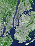
New York City is located on the coast of the Northeastern United States at the mouth of the Hudson River in southeastern New York state. It is located in the New York–New Jersey Harbor Estuary, the centerpiece of which is the New York Harbor, whose deep waters and sheltered bays helped the city grow in significance as a trading city. Much of New York is built on the three islands of Manhattan, Staten Island, and western Long Island, making land scarce and encouraging a high population density.

Population density and elevation above sea level in Greater NYC, U.S. (2010) New York City is especially vulnerable to sea level rise. Urban-Rural Population and Land Area Estimates, v2, 2010 Greater NYC, U.S. (13873743475).jpg
Population density and elevation above sea level in Greater NYC, U.S. (2010) New York City is especially vulnerable to sea level rise.

The Hudson River flows from the Hudson Valley into New York Bay, becoming a tidal estuary that separates the Bronx and Manhattan from Northern New Jersey. The Harlem River, another tidal strait between the East and Hudson Rivers, separates Manhattan from the Bronx.

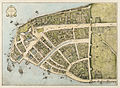
The city's land has been altered considerably by human intervention, with substantial land reclamation along the waterfronts since Dutch colonial times. Reclamation is most notable in Lower Manhattan with modern developments like Battery Park City. Much of the natural variations in topography have been evened out, particularly in Manhattan. [1] The West Side of Manhattan retains some hilliness, especially in Upper Manhattan, while the East Side has been considerably flattened. Duffy's Hill in East Harlem is one notable exception to the East Side's relatively level grade.

The city's land area is estimated to be 321 square miles (830 km2). [2] However, a more recent estimate calculates a total land area of 304.8 square miles (789.4 km2). [3] Icebergs are often compared in size to the area of Manhattan. [4] [5] [6]

The highest natural point in the city is Todt Hill on Staten Island, which at 409.8 ft (124.9 m) above sea level is the highest hill on the Eastern Seaboard south of Maine. The summit of the ridge is largely covered in woodlands as part of the Staten Island Greenbelt. Many places have been identified as the geographic center of the city, including a plaque in the center of Queens Boulevard and 58th Street, in Woodside, Queens. [7]

Geology

The boroughs of New York City straddle the border between two geologic provinces of eastern North America. Brooklyn and Queens, located on Long Island, are part of the eastern coastal plain. Long Island is a massive moraine which formed at the southern fringe of the Laurentide Ice Sheet during the last ice age. The Bronx and Manhattan lie on the eastern edge of the Newark Basin, a block of the Earth's crust which sank downward during the disintegration of the supercontinent Pangaea during the Triassic period. The Palisades Sill on the New Jersey shore of the Hudson River exposes ancient, once-molten rock that filled the basin. The bedrock underlying much of Manhattan is a mica schist known as Manhattan schist [8] of the Manhattan Prong physiographic region. It is a strong, competent metamorphic rock that was produced when Pangaea formed. It is well suited for the foundations of tall buildings. In Central Park, outcrops of Manhattan schist occur and Rat Rock is one rather large example. [9] [10] [11]

Geologically, a predominant feature of the substrata of Manhattan is that the underlying bedrock base of the island rises considerably closer to the surface near Midtown Manhattan, dips down lower between 29th Street and Canal Street, then rises toward the surface again in Lower Manhattan. It has been widely believed that the depth to bedrock was the primary underlying reason for the clustering of skyscrapers in the Midtown and Financial District areas, and their absence over the intervening territory between these two areas. [12] [13] However, research has shown that economic factors played a bigger part in the locations of these skyscrapers. [14] [15] [16]

According to the United States Geological Survey, an updated analysis of seismic hazard in July 2014 revealed a "slightly lower hazard for tall buildings" than previously assessed. Scientists estimated this lessened risk based upon a lower likelihood than previously thought of slow shaking near New York City, which would be more likely to cause damage to taller structures from an earthquake in the vicinity of the city. [17]

Adjacent counties

New York

New Jersey

Boroughs

Map of Manhattan, the most densely populated borough of New York City, and the economic, cultural and administrative center of the city. Manhattan NYC OpenStreetMap 2023-08-21.png
Map of Manhattan, the most densely populated borough of New York City, and the economic, cultural and administrative center of the city.

New York City comprises five boroughs, an unusual form of government used to administer the five constituent counties that make up the city. Throughout the boroughs there are hundreds of distinct neighborhoods, many with a definable history and character all their own. If the boroughs were each independent cities, four of the boroughs (Brooklyn, Queens, Manhattan, and the Bronx) would be among the ten most populous cities in the United States.

Environmental issues

Central Park is nearly twice as big as the world's second-smallest country, Monaco. Historically its reservoirs were important components of the city's water supply. Centralpark 20040520 121402 1.1504.jpg
Central Park is nearly twice as big as the world's second-smallest country, Monaco. Historically its reservoirs were important components of the city's water supply.

New York City plays an important role in the green policy agenda because of its size. Environmental groups make large efforts to help shape legislation in New York because they see the strategy as an efficient way to influence national programs. New York City's economy is larger than Switzerland's, a size that means the city has potential to set new de facto standards. Manufacturers are also attuned to the latest trends and needs in the city because the market is simply too big to ignore.

Although cities like San Francisco or Portland, Oregon are most commonly associated with urban environmentalism in the United States, New York City's unique urban footprint and extensive transportation systems make it more sustainable than most American cities.

Maps and satellite images

See also

Related Research Articles

<span class="mw-page-title-main">Manhattan</span> Borough in New York City coextensive with county in the State of New York

Manhattan is the most densely populated and geographically smallest of the five boroughs of New York City. The borough is coextensive with New York County, the smallest county by geographical area in the U.S. state of New York. Located almost entirely on Manhattan Island near the southern tip of the state, Manhattan constitutes the geographical and demographic center of the Northeast megalopolis and the urban core of the New York metropolitan area. Manhattan serves as New York City's economic and administrative center and has been described as the cultural, financial, media, and entertainment capital of the world.

<span class="mw-page-title-main">New York metropolitan area</span> Metro area surrounding New York City

The New York metropolitan area, broadly referred to as the Tri-State area and often also called Greater New York City Area, is the largest metropolitan area in the world by urban landmass, encompassing 4,669.0 sq mi (12,093 km2). The New York metropolitan area is one of the most populous metropolitan areas in the world and the only U.S. metropolitan area larger than twenty million residents as of the 2020 United States census. The vast metropolitan area includes New York City, the nation's most populous city, Long Island, the Mid- and Lower Hudson Valley in New York State; fourteen counties and eleven of the largest cities in New Jersey; and six of the seven largest cities in Connecticut. The phrase "Tri-State area" usually refers to New York / New Jersey / Connecticut, although an increasing number of people who work in New York City commute from Pennsylvania, particularly from the Lehigh Valley, Bucks County, and Poconos regions in eastern Pennsylvania, making the metropolitan area span four states. The New York metropolitan area is the geographic and demographic hub of the larger Northeast megalopolis.

<span class="mw-page-title-main">City of Greater New York</span> Term for New York City following the 1898 consolidation with surrounding cities and towns

The City of Greater New York was the term used by many politicians and scholars for the expanded City of New York created on January 1, 1898, by consolidating the existing City of New York with Brooklyn, western Queens County, and Staten Island. The section of the Bronx west of the Bronx River had been annexed to the City and County of New York in 1874 and was known as the Annexed District. The section of the Bronx east of the Bronx River had been annexed to the City and County of New York in 1895.

<span class="mw-page-title-main">New York City</span> Most populous city in the United States

New York, often called New York City or simply NYC, is the most populous city in the United States, located at the southern tip of New York State on one of the world's largest natural harbors. The city comprises five boroughs, each of which is coextensive with a respective county. It is a global city and a cultural, financial, high-tech, entertainment, and media center with a significant influence on commerce, health care, scientific output, life sciences, research, technology, education, politics, tourism, dining, art, fashion, and sports. Home to the headquarters of the United Nations, New York is an important center for international diplomacy, and is sometimes described as the world's most important city and the capital of the world.

<span class="mw-page-title-main">Transportation in New York City</span>

The transportation system of New York City is a network of complex infrastructural systems. New York City, being the most populous city in the United States, has a transportation system which includes one of the largest and busiest subway systems in the world; the world's first mechanically ventilated vehicular tunnel; and an aerial tramway. New York City is home to an extensive bus system in each of the five boroughs; citywide and Staten Island ferry systems; and numerous yellow taxis and boro taxis throughout the city. Private cars are less used compared to other cities in the rest of the United States.

The borough president are the chief executives of the five boroughs of New York City. For most of the city's history, the office exercised significant executive powers within each borough, and the five borough presidents also sat on the New York City Board of Estimate. Since 1990, the borough presidents have been stripped of a majority of their powers in the government of New York City.

<span class="mw-page-title-main">Transportation Alternatives</span>

Transportation Alternatives is a non-profit organization in New York City which works to change New York City's transportation priorities to encourage and increase non-polluting, quiet, city-friendly travel and decrease automobile use. TransAlt seeks a transportation system based on a "Green Transportation Hierarchy" giving preference to modes of travel based on their relative benefits and costs to society. To achieve these goals, T.A. works in five areas: Cycling, Walking and Traffic Calming, Car-Free Parks, Safe Streets and Sustainable Transportation. Promotional activities include large group bicycle rides.

<span class="mw-page-title-main">Architecture of New York City</span>

The building form most closely associated with New York City is the skyscraper, which has shifted many commercial and residential districts from low-rise to high-rise. Surrounded mostly by water, the city has amassed one of the largest and most varied collection of skyscrapers in the world.

<span class="mw-page-title-main">Flags of New York City</span> Official flags of the U.S. city of New York City

The flags of New York City include the flag of New York City, the respective flags of the boroughs of The Bronx, Brooklyn, Manhattan, Queens, and Staten Island, and flags of certain city departments. The city flag is a vertical tricolor in blue, white, and orange and charged in the center bar with the seal of New York City in blue. The tricolor design is derived from the flag of the Dutch Monarchy—the Prince's Flag—as used in New Amsterdam in 1625.

<span class="mw-page-title-main">Boroughs of New York City</span> Administrative divisions of New York City

The Boroughs of New York City are the five major governmental districts that compose New York City. The boroughs are the Bronx, Brooklyn, Manhattan, Queens, and Staten Island. Each borough is coextensive with a respective county of the State of New York: The Bronx is Bronx County, Brooklyn is Kings County, Manhattan is New York County, Queens is Queens County, and Staten Island is Richmond County.

<span class="mw-page-title-main">New York City ethnic enclaves</span> Ethnic group in New York City

Since its founding in 1625 by Dutch traders as New Amsterdam, New York City has been a major destination for immigrants of many nationalities who have formed ethnic enclaves, neighborhoods dominated by one ethnicity. Freed African American slaves also moved to New York City in the Great Migration and the later Second Great Migration and formed ethnic enclaves. These neighborhoods are set apart from the main city by differences such as food, goods for sale, or even language. Ethnic enclaves provide inhabitants security in work and social opportunities, but limit economic opportunities, do not encourage the development of English speaking, and keep immigrants in their own culture.

New York City has the largest population of Italian Americans in the United States as well as North America, many of whom inhabit ethnic enclaves in Brooklyn, the Bronx, Manhattan, Queens, and Staten Island. New York is home to the third largest Italian population outside of Italy, behind Buenos Aires, Argentina (first) and São Paulo, Brazil (second). Over 2.6 million Italians and Italian-Americans live in the greater New York metro area, with about 800,000 living within one of the five New York City boroughs. This makes Italian Americans the largest ethnic group in the New York metro area.

In the United States, the Manhattan Prong of the New England Uplands is a smaller belt of ancient rock in southern New York, parts of Westchester County, and upland portions of southwestern Connecticut. The bedrock underlying much of Manhattan consists of three rock formations: Inwood marble, Fordham gneiss, Manhattan schist, and Tuckahoe marble, which are well suited for the foundations of Manhattan's skyscrapers.

The following is an alphabetical list of articles related to New York City. New York City is a city in the United States state of New York.

References

Notes

    Sources

    1. Lopate, Phillip (2004). Waterfront: A Walk Around Manhattan. Anchor Press. ISBN   0-385-49714-8.
    2. "Land Use Facts". New York City Department of City Planning. Archived from the original on 2007-03-30. Retrieved 2007-03-13.
    3. Roberts, Sam (2008-05-22). "It's Still a Big City, Just Not Quite So Big". The New York Times . Retrieved 2008-05-22.
    4. Zamira Rahim (September 14, 2020). "A chunk of ice twice the size of Manhattan has broken off Greenland in the last two years". CNN. Retrieved September 19, 2020.
    5. Maddie Stone (February 21, 2019). "An Iceberg 30 Times the Size of Manhattan Is About to Break Off Antarctica". Gizmodo . Archived from the original on October 27, 2019. Retrieved October 27, 2019.
    6. Lorraine Chow (November 1, 2018). "An iceberg 5 times bigger than Manhattan just broke off from Antarctica". Business Insider . Archived from the original on October 27, 2019. Retrieved October 27, 2019.
    7. "This Spot in Queens Claims to be the Center of NYC. It's Not". www.ny1.com. Retrieved 2021-10-04.
    8. The fact that the immediate layer of bedrock in the Bronx is Fordham gneiss, while that of Manhattan is schist has led to the expression: "The Bronx is gneiss (nice) but Manhattan is schist." Eldredge, Niles and Horenstein, Sidney (2014). Concrete Jungle: New York City and Our Last Best Hope for a Sustainable Future. Berkeley, California: University of California Press. p. 42, n1. ISBN   978-0-520-27015-2.
    9. "Manhattan Schist in Bennett Park". February 4, 2019. Archived from the original on February 12, 2012.
    10. John H. Betts The Minerals of New York City Archived March 13, 2020, at the Wayback Machine originally published in Rocks & Minerals magazine, Volume 84, No. 3 pages 204–252 (2009).
    11. Samuels, Andrea. "An Examination of Mica Schist by Andrea Samuels, Micscape magazine. Photographs of Manhattan schist". Microscopy-uk.org.uk. Archived from the original on January 2, 2013. Retrieved April 20, 2013.
    12. "Manhattan Schist in New York City Parks – J. Hood Wright Park". New York City Department of Parks & Recreation. Archived from the original on March 3, 2014. Retrieved February 27, 2014.
    13. Quinn, Helen (June 6, 2013). "How ancient collision shaped New York skyline". BBC Science. BBC.co.uk. Archived from the original on June 13, 2013. Retrieved June 13, 2013. These rocks are Manhattan schist, part of that ancient supercontinent, fragments of Pangaea left behind when the continent split. They are just glimpses of what is below the surface in abundance in Downtown and Midtown. And it is these fragments of very hard rock that provide the perfect foundations for New York's highest buildings. Where Manhattan schist can be found very close to the surface you can build high, and so Downtown and Midtown have become home to Manhattan's tallest buildings.
    14. Jason Barr; Tassier, Troy; and Trendafilov, Rossen. "Depth to Bedrock and the Formation of the Manhattan Skyline, 1890–1915" Archived April 25, 2016, at the Wayback Machine , The Journal of Economic History , December 2011 – Volume 71, Issue 04. Accessed August 3, 2016.
    15. Chaban, Matt (January 17, 2012). "Uncanny Valley: The Real Reason There Are No Skyscrapers in the Middle of Manhattan". The New York Observer. Archived from the original on March 2, 2014. Retrieved February 26, 2014.
    16. Chaban, Matt (January 25, 2012). "Paul Goldberger and Skyscraper Economist Jason Barr Debate the Manhattan Skyline" (PDF). The New York Observer. Archived from the original on March 2, 2014. Retrieved February 26, 2014.
    17. Jessica Robertson & Mark Petersen (July 17, 2014). "New Insight on the Nation's Earthquake Hazards". United States Geological Survey. Archived from the original on August 11, 2014. Retrieved August 12, 2014.
    18. 1 2 3 4 5 "New York State Department of Labor - Population Estimates". Archived from the original on 2007-01-04. Retrieved 2006-11-02.
    19. Toop, David (1992). Rap Attack 2: African Rap to Global Hip-Hop. Serpents Tail. ISBN   1-85242-243-2.
    20. Frazier, Ian (2006-06-26). "Utopia, the Bronx". The New Yorker. Retrieved 2007-03-26.
    21. O'Donnell, Michelle (2006-07-04). "In Queens, It's the Glorious 4th, and 6th, and 16th, and 25th..." New York Times. Retrieved 2006-07-19.
    22. Roberts, Sam (2006-01-10). "Black Incomes Surpass Whites in Queens". The New York Times. Retrieved 2007-03-28.

    Further reading