Rockaway Inlet is a strait connecting Jamaica Bay, wholly within New York City, with the Atlantic Ocean. It separates the Rockaway Peninsula in Queens from the Floyd Bennett Field (formerly Barren Island) in Brooklyn.
Rockaway Inlet is a strait connecting Jamaica Bay, wholly within New York City, with the Atlantic Ocean. It separates the Rockaway Peninsula in Queens from the Floyd Bennett Field (formerly Barren Island) in Brooklyn.
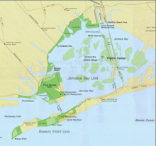
Rockaway Inlet is bounded by Brooklyn to the north and Rockaway Peninsula to the south. It is the entrance to Jamaica Bay, and most of the inlet is within the boundary of Gateway National Recreation Area. Its entrance is marked by a light on a jetty extending southward from Rockaway Point. The entrance channel extends westward of the jetty and is marked by lighted buoys. It has a depth of about 15 feet midchannel with a shoal of only one foot. In 1968 a light failed and the tanker Mary A. Whalen ran aground, resulting in a case entitled United States v. Reliable Transfer Co. about dividing damage payments. [1]
The inlet is spanned by the Marine Parkway–Gil Hodges Memorial Bridge.
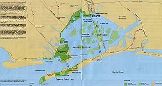
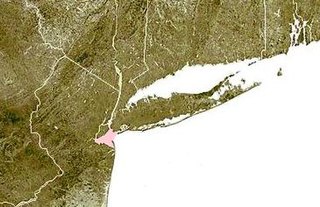
Jamaica Bay is an estuary on the southern portion of the western tip of Long Island, in the U.S. state of New York. The estuary is partially man-made, and partially natural. The bay connects with Lower New York Bay to the west, through Rockaway Inlet, and is the westernmost of the coastal lagoons on the south shore of Long Island. Politically, it is primarily divided between the boroughs of Brooklyn and Queens in New York City, with a small part touching Nassau County.
Lower New York Bay is a section of New York Bay south of the Narrows. The eastern end of the Bay is marked by two spits of land, Sandy Hook, New Jersey, and Rockaway, Queens. The waterway between the spits connects the Bay to the Atlantic Ocean at the New York Bight. Traversing the floor of the Bay southeasterly from the Narrows to the Bight and beyond is Hudson Canyon.

The New York–New Jersey Harbor Estuary, also known as the Hudson-Raritan Estuary, is in the northeastern states of New Jersey and New York on the East Coast of the United States. The system of waterways of the Port of New York and New Jersey forms one of the most intricate natural harbors in the world and one of the busiest ports of the United States. The harbor opens onto the New York Bight in the Atlantic Ocean to the southeast and Long Island Sound to the northeast.
Barren Island is a peninsula and former island on the southeast shore of Brooklyn in New York City. Located on Jamaica Bay, it was geographically part of the Outer Barrier island group on the South Shore of Long Island. The island was occupied by the Lenape Native Americans prior to the arrival of Dutch settlers in the 17th century. Its name is a corruption of Beeren Eylandt, the Dutch-language term for "Bears' Island".

Neponsit is a small affluent neighborhood located on the western half of the Rockaway Peninsula, the southernmost area of the New York City borough of Queens. The area starts at Beach 142nd Street and ends at Beach 149th Street. It borders the neighborhood of Belle Harbor to the east and Jacob Riis Park on the west. Jamaica Bay and the Atlantic Ocean are the northern and southern borders. The neighborhood is part of Queens Community Board 14. As of January 1, 2007, the neighborhood's population reached just over 2,000, making it one of the smallest communities on the peninsula and in the entire borough of Queens.

The Far Rockaway Branch is an electrified rail line and service owned and operated by the Long Island Rail Road in the U.S. state of New York. The branch begins at Valley Interlocking, just east of Valley Stream station. From Valley Stream, the line heads south and southwest through southwestern Nassau County, ending at Far Rockaway in Queens, thus reentering New York City. LIRR maps and schedules indicate that the Far Rockaway Branch service continues west along the Atlantic Branch to Jamaica. This two-track branch provides all day service in both directions to Grand Central Madison and Penn Station, both in Midtown Manhattan.
Shinnecock Inlet is the easternmost of five major inlets connecting bays to the Atlantic Ocean through the narrow 100-mile-long (160 km) Outer Barrier that stretches from New York City to Southampton, New York on the south shore of Long Island. It splits Westhampton Island from the peninsula extending from Southampton Village. The inlet was formed by the 1938 New England hurricane, which killed several people when it permanently broke through the island in Hampton Bays, New York. The name comes from the Shinnecock Indian Nation.

The Outer Barrier, also known as the Long Island and New York City barrier islands, refers to the string of barrier islands that divide the lagoons south of Long Island, New York from the Atlantic Ocean. These islands include Long Beach Barrier Island, Barnum Island, Jones Beach Island, Fire Island and Westhampton Island. The outer barrier extends 75 miles (121 km) along the South Shore of Long Island, from the Rockaway Peninsula in New York City to the east end of Shinnecock Bay in Suffolk County.

The Montauk Branch is a rail line owned and operated by the Long Island Rail Road in the U.S. state of New York. The line runs the length of Long Island, 115 miles (185 km) from Long Island City to Montauk. However, in LIRR maps and schedules for public use, the term Montauk Branch refers to the line east of Babylon; service from Jamaica to Babylon is covered by separate Babylon Branch schedules, while the line west of Jamaica is currently unused for passenger service. A select number of Montauk Branch trains operate via the Main Line during peak hours.

Dead Horse Bay is a small body of water off Barren Island, between the Gerritsen Inlet and Rockaway Inlet in the New York City borough of Brooklyn.

Jacob Riis Park, also called Jacob A. Riis Park and Riis Park, is a seaside park on the southwestern portion of the Rockaway Peninsula in the New York City borough of Queens. It lies at the foot of the Marine Parkway–Gil Hodges Memorial Bridge, east of Fort Tilden, and west of Neponsit and Rockaway Beach. Originally run by the New York City Department of Parks and Recreation, it later became part of the Jamaica Bay Unit of the Gateway National Recreation Area, and is managed by the National Park Service (NPS). It features an extensive sand beach along the Atlantic Ocean coastline and several historic Art Deco structures.

Barnegat Inlet is a small inlet connecting the Barnegat Bay with the Atlantic Ocean in Ocean County, New Jersey. It separates Island Beach State Park and the Barnegat Peninsula from Long Beach Island. The Barnegat Lighthouse sits at the northern end of Long Beach Island along the inlet.
Bergen Basin is a tributary inlet to Jamaica Bay in Queens, New York, at the northern extremity of Grassy Bay, along the western boundary of John F. Kennedy International Airport. The airport was built on the marshes of Jamaica Bay surrounding Bergen Basin in 1942. Bergen Basin was previously known as Bergen's Landing Aqueduct or Bergen Creek.

Green Bus Lines, also referred to simply as Green Lines, was a private bus company in New York City, United States. It operated local service in Queens and express service to Manhattan until January 9, 2006, when the city-operated MTA Bus Company took over its routes. It was managed most recently by Jerome Cooper (1928–2015).

The East Rockaway Inlet is an arm of the Atlantic Ocean which separates the Rockaway Peninsula from the barrier island which includes the Nassau County, New York communities of Atlantic Beach, Long Beach and Lido Beach. The inlet is on the south shore of Long Island. It provides for a channel 12 feet deep and 250 feet wide. A 3,000 foot jetty on the western side of the channel was authorized but never constructed, and was eventually deauthorized by Congress in 1977.

Rockaway Parkway is a major commercial street in the Canarsie and Brownsville neighborhoods of Brooklyn, New York.

Springfield Junction was a junction between the Long Island Rail Road's Montauk Branch and Atlantic Branch in Laurelton, Queens, New York City, United States. It was located at the place where those two branches now begin to parallel, just east of Laurelton station and half a mile east of Springfield Boulevard. No rail station was located at the junction itself, however Springfield Gardens station was located nearby.

Perdido Pass, separating Alabama Point from Florida Point, is the mouth of the Perdido River. Perdido Pass forms a water passage that connects Perdido Bay with the Gulf of Mexico to the south, in the U.S. state of Alabama, 2 miles (3 km) west of the Alabama/Florida state line. A bridge spans Perdido Pass, connecting Alabama Point with Florida Point in Alabama. At the entrance into the Gulf, the 2 rock barriers, extending from the white beaches, are the west jetty & east jetty. The surrounding area is heavily developed, with high-rise condominiums. However, there are nearby beach-front parks, with Gulf State Park on the eastern side of Perdido Pass.

The Heights of Guan is a historical name given to a series of hills extending in a ridge along western Long Island in New York State. The ridge extends in an east-northeast direction across the modern-day New York City boroughs of Brooklyn and Queens, with hills varying in height from 100 to 150 feet. The southern slope of the ridge has a relatively steep drop and the northern slope is more gradual. Further to the south is an outwash plain bordered by the Atlantic Ocean. Geologically, the ridge is part of the Harbor Hill Moraine formed 13,000 to 12,000 years ago during the Wisconsin glaciation.

Howard was a former Long Island Rail Road station on the Rockaway Beach Branch. Located on marshland along the coast of Jamaica Bay south of the "WD Tower" near Hawtree Creek, it had no fixed address, and was south of what is today 165th Avenue, evidently within the Gateway National Recreation Area's Hamilton Beach Park.
40°34′24″N73°54′49″W / 40.5732°N 73.9136°W
| | This article about a location in Queens, New York is a stub. You can help Wikipedia by expanding it. |
| | This article about a location in Brooklyn, New York is a stub. You can help Wikipedia by expanding it. |