Crocheron Park

Last updated

Crocheron Park is a public park situated at 214th Street and 35th Avenue in Bayside, Queens, New York City. [1]

Contents

A view from the eastern end of Crocheron Park, overlooking Little Neck Bay and the Cross Island Parkway Crocheron5.jpg
A view from the eastern end of Crocheron Park, overlooking Little Neck Bay and the Cross Island Parkway
A gazebo at the eastern end of Crocheron Park Crocheron6.jpg
A gazebo at the eastern end of Crocheron Park
A field, walking path and small forested area in Crocheron Park Crocheron7.jpg
A field, walking path and small forested area in Crocheron Park
Playground equipment in Crocheron Park Crocheron8.jpg
Playground equipment in Crocheron Park
The western entrance to Crocheron Park Crocheron9.jpg
The western entrance to Crocheron Park

Hotel usage

Before becoming a park, the area facing Little Neck Bay was the summer hotel called the Crocheron House, which stood for nearly half a century. [2] The building resembled an Italian villa and included a square tower at one corner, large windows, and a broad piazza facing the water. [2] This hotel, prior to its destruction, drew attention around 1868: this was when Joseph Crocheron purchased Brown's Bayside House, enlarged it and turned it into a watering hole for politicians, theatrical people, and financiers. [3] Furthermore, this hotel included festivals and seafood dinners. [3] This place also became a magnet for a criminal named William Marcy "Boss" Tweed, the notorious Tammany Hall leader, who hid there following his escape in 1875. [3] Boss Tweed had escaped to this place from the Ludlow St. debtor's jail in December 1875 and it was said that Tweed, while heading for Spain, embarked to Cuba aboard a schooner brought to anchor in the bay by his friends [2]

The hotel's owner, Joseph Crocheron, was a well-known and experienced racer of horses along with Cornelius Vanderbilt, August Belmont, and more. [1] There is also a distinct number of Crocheron family members such as John Crocheron, who was a planter, whose will was dated December 13, 1695 and died a year after that date; another was Henry Crocheron (1829-1931), a member of Congress. [1] However, around 1907–08, the hotel was leveled in a fire and was since never rebuilt. [3] After it was burned down in 1908, the community took it upon themselves and raised funds to purchase 42 acres and gave them to the city to become Crocheron Park. [2]

Park

The original parcel of land was acquired during 1924. [1] Prior to its opening, Crocheron Park cost New York City $17,769 for each of its 51 acres; it also cost property owners in the local area of assessment in Bayside exactly $181,252.09. [4] The park was to comprise the entire area bounded by Crocheron avenue from 214th place, Maxwell avenue, 215th place, Vista avenue, and other blocks in the surrounding area. [4]

During the 1960s, the Parks Department intended to rebuild Crocheron Park; this included the repair or construction of new tennis courts. [5] The day before this answer was made, the Crocheron Park Tennis Committee issued a complaint that the courts were in a "deplorable state". [5] According to a department spokesman, plans were in motion to renovated the park, claiming it would be unwise to renovate the park, claiming it would be unwise to resurface the courts, when they intended to rebuild them. [5] Israel Kaufman, a member of the Tennis Committee, said a 500-name petition was sent to Newbold Morris, asking for repairs of the courts. [5]

A dedication was made on October 18, 1965 to the John Golden Section of Crocheron Park. [6] The ceremonies were attended by Mayor Wagner, Park Commissioner Newbold Morris, and Mr. Hymes, the sister of the late John Golden. [6]

New York Road Runners hosts a weekly 3.1-mile Open Run. [7]

Events held

A concert was held and given at Crocheron Park on August 13, 1965, and was attended by over 20,000 people. [8] Due to the increasing number of fans and audience, those in charge had to make use of two baseball fields. [8] Both the audience and musicians braved a steady rain drizzle occurring that very evening. [8]

On August 6, 1966. a New York Philharmonic Society orchestra concert was held in Bayside's Crocheron Park with a reception of 40,000 persons. [9] People cheered "bravos" for the musicians, for conductor Lukas Foss, and for Marian Anderson. [9] During the performance, there was an orderly incident: three youngsters almost disrupted the performance by firing paper clips at the orchestra from a nearby wooded area. [9] All three of these youngsters were caught by Patrolmen Joseph Leyer, James Miller, Thomas Carr, and Sergeant Andrew Lontos: the youths' names were withheld because of their ages. [9] This summer program was composed of Mozart's "Symphony Number 40," Tshaikovsky's "Francesa de Rimini," Aaron Copland's "Lincoln Portrait," and Ravel's "Daphnis and Chloe." [9] This program was co-sponsored by the Historical Society and Parks Department. [9]

Crocheron Park was used for many other festive events. One such event was Bayside's third Annual American Heritage Weekend which was held in August 1981. [10] The celebration included the day's re-enactment of parts from the American Revolution played out by the Historic Commands of the American Revolution. [10] There were those, however, who believed that none of the day's events matched their desires, enjoyments, or anything related to historical traditions. [10]

Furthermore, Crocheron Park was also used for running marathons. In August 1981, an all-day marathon was held in Crocheron Park and was attended by 19 long-distance runners. [11] This event was hosted by The Broadway Ultramarathon Society and headed by Ben Grundstein and Richard Innamorato who finished third in the race and ran over 77 miles. [11] The race, after 12 hours of running, walking, and sweating, was won by 42-year-old Bob Vandekieff, who covered a distance of a little over 84 miles. [11]

Related Research Articles

<span class="mw-page-title-main">Flushing Meadows–Corona Park</span> Public park in Queens, New York

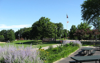
Flushing Meadows–Corona Park, often referred to as Flushing Meadows Park, or simply Flushing Meadows, is a public park in the northern part of Queens in New York City, New York, U.S. It is bounded by I-678 on the east, Grand Central Parkway on the west, Flushing Bay on the north, and Union Turnpike on the south. Flushing Meadows–Corona Park is the fourth-largest public park in New York City, with a total area of 897 acres (363 ha).

<span class="mw-page-title-main">Inwood Hill Park</span> Public park in Manhattan, New York

Inwood Hill Park is a 196 acres (79 ha) public park in the Inwood neighborhood of Manhattan, New York City, operated by the New York City Department of Parks and Recreation. On a high schist ridge that rises 200 feet (61 m) above the Hudson River from Dyckman Street to the northern tip of the island, Inwood Hill Park's densely folded, glacially scoured topography contains the largest remaining old-growth forest on the island of Manhattan. The area is also known as the Shorakapkok Preserve, shorakapkok meaning 'the sitting place' in the Munsee language used by the Wecquaesgeek tribe who inhabited the area for nearly 700 years. Unlike other Manhattan parks, Inwood Hill Park is largely natural and consists of mostly wooded, non-landscaped hills.

<span class="mw-page-title-main">Flushing, Queens</span> Neighborhood of northern Queens in New York City

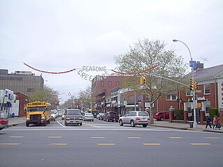
Flushing is a neighborhood in the north-central portion of the New York City borough of Queens. The neighborhood is the fourth-largest central business district in New York City. Downtown Flushing is a major commercial and retail area, and the intersection of Main Street and Roosevelt Avenue at its core is the third-busiest in New York City, behind Times Square and Herald Square.

<span class="mw-page-title-main">Douglaston–Little Neck, Queens</span> Neighborhood of Queens in New York City

Douglaston–Little Neck is a neighborhood in the northeastern part of the New York City borough of Queens. The community is located on the North Shore of Long Island, bordered to the east by the region of Great Neck in Nassau County, to the south by Glen Oaks and the North Shore Towers, and to the west by Bayside.

<span class="mw-page-title-main">Cross Island Parkway</span> Highway in New York

The Cross Island Parkway is a controlled-access parkway in New York City, part of the Belt System of parkways running along the perimeter of the boroughs of Queens and Brooklyn. The Cross Island Parkway runs 10.6 miles (17.1 km) from the Whitestone Expressway in Whitestone past the Throgs Neck Bridge, along and across the border of Queens and Nassau County to meet up with the Southern State Parkway, acting as a sort of separation point which designates the limits of New York City. The road is designated as New York State Route 907A (NY 907A), an unsigned reference route, and bears the honorary name 100th Infantry Division Parkway.

<span class="mw-page-title-main">Bayside, Queens</span> Neighborhood in New York City

Bayside is a neighborhood located in the New York City borough of Queens. It is bounded by Whitestone to the northwest, the Long Island Sound and Little Neck Bay to the northeast, Douglaston to the east, Oakland Gardens to the south, and Fresh Meadows to the west. CNN Money ranked Bayside as one of the most expensive housing markets nationally when analyzing comparable detached homes throughout the United States. Despite its large housing stock of free-standing homes, it nationally ranks high in population density.

<span class="mw-page-title-main">Marine Park (Brooklyn park)</span> Public park in Brooklyn, New York

Marine Park is a public park located in the neighborhood of Marine Park in Brooklyn, New York. Its 798 acres (3.2 km2) surround the westernmost inlet of Jamaica Bay. Most of the land for Marine Park was donated to New York City to be turned into public park land by the Whitney family in 1920 and by Frederic B. Pratt and Alfred Tredway White, who jointly donated 150 acres (0.61 km2) in 1917. The land donated consists of the area between the current day Fillmore Avenue and Gerritsen Avenue and East 38th Street. Originally almost 2,000 acres (810 ha), over half of which has been donated to the National Park Service as part of the Gateway National Recreation Area, the park is mainly a fertile salt marsh which is supplied with freshwater from Gerritsen Creek.

<span class="mw-page-title-main">Flushing Cemetery</span>

Flushing Cemetery is a cemetery in Flushing in the borough of Queens in New York City, New York.

<span class="mw-page-title-main">Alley Pond Park</span> Public park in Queens, New York

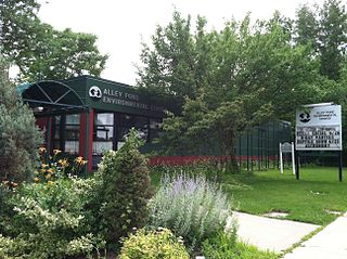
Alley Pond Park is the second-largest public park in Queens, New York City, occupying 655.3 acres (265.2 ha). The park is bordered to the east by Douglaston, to the west by Bayside, to the north by Little Neck Bay, and to the south by Union Turnpike. The Cross Island Parkway travels north-south through the park, while the Long Island Expressway and Grand Central Parkway travel east-west through the park. The park primarily consists of woodlands south of the Long Island Expressway and meadowlands north of the expressway. It is run and operated by the New York City Department of Parks and Recreation.

<span class="mw-page-title-main">Bay Terrace, Queens</span> Neighborhood of Queens in New York City

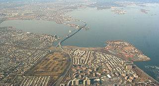
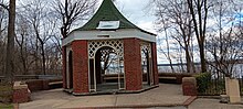
Bay Terrace is a neighborhood in the northeastern section of the New York City borough of Queens. It is often considered part of the larger area of Bayside. Bay Terrace overlooks the East River and the approaches to the Throgs Neck Bridge from the Clearview Expressway and Cross Island Parkway. It is bounded on the west by the Clearview Expressway, on the south by 26th and 28th Avenues, to the east by the Little Neck Bay, and to the north by the East River.

The North Shore Bus Company operated public buses in Queens, New York City. It was established in 1920 as the successor to the New York and North Shore Traction Company trolley system, and operated until 1947 when it went bankrupt, and its operations were taken over by the New York City Board of Transportation.

<span class="mw-page-title-main">Highland Park (Brooklyn)</span> Public park in Brooklyn, New York

Highland Park is a park located in Brooklyn, New York City, on the border with Queens. Established in 1901, Highland Park borders Cypress Hills, Brooklyn—part of the East New York neighborhood—to its south, and it abuts Glendale and Ridgewood, Queens, to its north.

<span class="mw-page-title-main">Isham Park</span> Public park in Manhattan, New York

Isham Park is a 20-acre (81,000 m2) historic park located in Inwood, Manhattan, New York City. The park was created in large part through gifts to the city from the Isham family of land from the William Bradley Isham estate. It sits roughly between Broadway, Isham Street, Seaman Avenue, and West 214th and 215th Streets.

<span class="mw-page-title-main">Broadway–Flushing, Queens</span> Neighborhood of Queens in New York City

Broadway–Flushing is a historic district and residential subsection of Flushing, Queens, New York City. The neighborhood comprises approximately 2,300 homes. It is located between 155th and 170th Streets to the west and east respectively, and is bounded on the north by Bayside and 29th Avenues, and on the south by Northern Boulevard and Crocheron Avenue. Broadway–Flushing is listed on the National Register of Historic Places.

<span class="mw-page-title-main">Juniper Valley Park</span> Public park in Queens, New York

Juniper Valley Park is a 55.247-acre (223,580 m2) public park located within Middle Village, Queens, New York, United States. The park is bordered by Juniper Boulevard North on the north, Juniper Boulevard South on the south, Lutheran Avenue on the west, and Dry Harbor Road on the east; it is split into two parts by 80th Street.

Portland, Maine, is home to many neighborhoods.

<span class="mw-page-title-main">Soundview Park</span> Public park in the Bronx, New York

Soundview Park is a 205-acre (83 ha) park on Clason Point in the southern portion of the Bronx, New York City. The park is adjacent to the Clason Point, Hunts Point, and Soundview neighborhoods, situated where the Bronx River flows into the East River, roughly opposite Rikers Island and LaGuardia Airport. The park is bounded by the Bronx River Estuary/East River, Lafayette Avenue, Morrison Avenue, Story Avenue, Metcalf Avenue, O'Brien Avenue, and Bronx River Avenue.

<span class="mw-page-title-main">Baisley Pond Park</span> Public park in Queens, New York

Baisley Pond Park is a public park located in the southeastern part of Queens, New York City, bordering the neighborhoods of South Jamaica, Rochdale, and St. Albans. It covers 109.61 acres (44.36 ha), including the 30-acre (12 ha) Baisley Pond in the center of the park. It is maintained by the New York City Department of Parks and Recreation.

St. Mary's Park is a public park in the Mott Haven neighborhood in the South Bronx section of the Bronx, New York City. The park has sporting facilities and an indoor recreation center.

<span class="mw-page-title-main">Edgemere Landfill</span> Former landfill in Queens, New York

Edgemere Landfill is a former municipal landfill located in Edgemere on the Rockaway peninsula in Queens, New York City. It is located on a man-made peninsula on the Jamaica Bay shoreline, at the eastern end of the Rockaway peninsula. A portion of the site is currently open to the public as Rockaway Community Park. The entire site is owned by the New York City Department of Parks and Recreation.

References

  1. 1 2 3 4 Cruise, Philip J. "Know Your Parks In Queens: New Article in Series by Park Department Director Treats of Many Attractions of Crocheron Park". Long Island Star. 4 MAY. 1936
  2. 1 2 3 4 Gayle, Margot. "New York's Changing Scene". Sunday Times. 7 JUN. 1976
  3. 1 2 3 4 Anonymous. "Crocheron Park Encampment Was Once a Plush Hotel". Bayside Times. 17 MAY 1979
  4. 1 2 Anonymous. "Crocheron Park Cost Is $181,252 To Land Owners". Flushing Journal. 31 JUL. 1928
  5. 1 2 3 4 Anonymous. "New Tennis Courts Included in Park Plan". Long Island Daily Press. 30 JUL. 1963
  6. 1 2 Anonymous. "Dedicate Golden Park Oct. 18th". Bayside Times. 30 SEP. 1965
  7. Staff, NYRR (2023-08-23). "Crocheron Park=NYRR" . Retrieved 2023-08-23.
  8. 1 2 3 Anonymous. "Concert Plays to 20,000". Long Island Daily Press. 14 AUG. 1965
  9. 1 2 3 4 5 6 Leichtlein, Ken. "'Music Hath Charms' for 40,000". Long Island Star-Journal. 8 AUG. 1966
  10. 1 2 3 Arneberg, Marlanne. "In Bayside, Dampened Festivity". NEWSDAY. 9 AUG. 1981
  11. 1 2 3 Caligiure, Raymond. "A Grueling Afternoon in the Park". Bayside Times. 27 AUG. 1981

40°46′17″N73°46′05″W / 40.77139°N 73.76806°W / 40.77139; -73.76806