Chelsea Park is a park in the Chelsea neighborhood of Manhattan, New York City, that dates back to 1910. The park has sports fields, basketball and handball courts, a children's playground and space for sitting. The surface is mostly tarmac or artificial turf, with pits for the plane trees and some plots with annual flower plantings. There is a statue to a World War I soldier, the "Doughboy Statue", erected in 1921. The process of approval, funding and clearing the tenements that occupied the site was protracted. The park has since been upgraded several times by the Works Progress Administration and the New York City Department of Parks and Recreation.
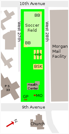
Chelsea Park is located between Ninth and Tenth Avenues, and between West 27th and West 28th Streets in Manhattan.[1] The park covers almost 4 acres (1.6ha).[2] There is fencing around the park to contain the active play areas, with gates at various points. The soccer pitch is surrounded by taller fencing while the rest of the park is surrounded by shorter fences.[2]
The area between West 26th and West 28th Streets and 9th and 10th Avenues is a superblock, comprising two normal-sized blocks. West 27th Drive is a driveway used only for service access, with the park occupying most of the block to the north of the drive.[3] To the south along 26th Street are three 12-to-14-story brick towers run by the New York City Housing Authority in the southern part of the superblock, as well as a public school (PS33 Chelsea Prep) and the Hudson Guild Settlement House.[4][3] The annex to the Morgan General Mail Facility occupies the block directly to the north of the park.[5] The Church of the Holy Apostles, built in 1848, is located on the east side of 9th Avenue across from the park. It is located within the Penn South housing complex.[5]
Physical
Infrastructure
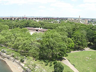
Chelsea Park has spaces for both passive and active recreation.[2] It is one of the busier parks in the neighborhood.[1] It contains baseball diamonds, basketball courts and six handball courts.[1] The artificial turf sports field covers about one third of the area.[6] The P.O. David Willis Basketball Court is named after the New York City Police Department officer David Willis (1964–95), who used to patrol the park.[7] There are public washrooms at West 27th Street and 9th Avenue, open year-round.[1] The park contains a District Health Center, a low-rise red brick building in the eastern part of the park.[3]
Ecology
There are no artificial or natural ponds. As of 2008 there were 27 mature London plane (Platanus × hispanica) trees with heights of 15 to 20 metres (49 to 66ft) around the perimeter of the park, and another 28 similar trees scattered through the interior. Most of the trees are in pits, because most of the ground surface is impermeable. The beds of annual plants around the monument and the health center are the only vegetated and permeable areas of the park other than the tree pits.[6] The northwest section of the park has less vegetation than the southeast section.[8]
The six-story Morgan Mail Building along the northern perimeter is a high-collision site for birds, with collisions peaking in mid May.[9] The first two stories of the building have featureless concrete walls, while the upper four stories are 75% covered with reflective glass panels installed over the concrete wall to give the appearance of windows.[10] A study in the spring and autumn of 2005 and 2006 collected the corpses of many migratory birds that had collided with the windows of the six-story USPS building, deceived by the reflections of the greenery in the park.[6] It seemed that the birds generally had adequate stores of fat (energy), and it was not clear whether they were stopping in Chelsea Park to replenish their energy or as a reaction to the inhospitable and unfamiliar city landscape.[11] About 80% of collisions are fatal, with most collisions occurring during the day.[12] Most are found along the southeast perimeter, where there are most trees, while relatively few are found along the playing field perimeter. This suggests that the reflections of trees in the glass panels are a major factor.[13]
The park is one of nine New York City parks with monuments to local heroes of World War I (1914–18). The Chelsea Park Memorial, also known as the Doughboy Statue, is a granite stele 14 feet (4.3m) tall fronted by a plinth supporting a bronze statue of an American soldier.[14] ("Doughboy" is a slang term for an infantryman that was widely used in World War I.[14]) The plinth bears the inscription: "To the Soldiers and Sailors of Chelsea World War 1914–1918".[14] The monument is surrounded by cobblestone.[3] It stands in front of the more recently built Health Center.[15]
The memorial was designed by the architect Charles Rollinson Lamb (1860–1942). The statue was created by the French-born sculptor Philip Martiny (1858–1927) and cast by the Roman Bronze Works foundry of New York.[14] The soldier holds a rifle and has a flag draped over his shoulders.[14] He strikes a commanding pose, defying the enemy.[16] The city's Art Commission, chaired by sculptor Robert Aitken, rejected Martiny's first submission in which the doughboy's pose was less dynamic.[17] Martiny used the same model for the doughboy as he did for his next statue of a soldier, in Greenwich Village. The soldier's aggressive pose is exactly the same as in Martiny's poster for the propaganda film Under Four Flags (1918).[15]
Gateposts
Also in front of the District Health Center there are two pairs of memorial gate posts that were commissioned by the Horatio Seymour Tammany Club and installed in 1926.[18] They commemorate the former borough president Frank L Dowling, the municipal civic court leader Frank J. Goodwin and the New York State Democratic Committee member William L. Kavanagh.[19]
History
Early years (1904–18)
The Chelsea Improvement Society proposed a playground for the park's current location in 1904 due to the paucity of parks along Ninth Avenue, with no parks on the street between DeWitt Clinton Park at 53rd Street and Hudson Park at Varick Street.[20] At the time, P.S. 33 occupied an adjacent lot.[21] Land had been set aside for a proposed Carnegie library to the east.[20] The rest of the area was full of tenements.[1][21] One reader wrote to The New York Times opposing the park and advocating another park site further north that would be located near a greater number of people.[22] Another reader proposed a larger park.[23] The legislature passed bills authorizing the park twice, but both times the mayor vetoed the bills as an "infringement of home rule".[24] $2.23 million was set aside to acquire the park in summer 1905.[25]
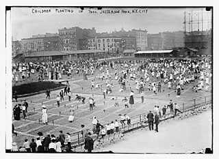
The city's parks department finally acquired the titles for all the required properties in 1906.[26] At the time, the acquisition comprised approximately 3.177 acres (1.286ha).[27] Demolitions continued at a slow pace: by July 1907, only two cellars had been cleared.[28] Filling started on the excavated properties by the end of that year.[29] A temporary playground was built in 1908.[30] The first permanent playground in the park was opened in June 1910.[31] By that time, a baseball field was planned for the park.[32] The New York City Board of Recreation, which had recently been formed, began to arrange sporting events that drew crowds of spectators.[1]
Interwar period (1919–41)
The Chelsea Doughboy Statue, which cost $10,000, was donated by the Chelsea Memorial Committee and dedicated on April 7, 1921.[1] The decorative gateposts commemorating Dowling, Goodwin, and Kavanagh were installed in 1926.[18] On August 18, 1925, a water tower from a nearby building collapsed on the park, injuring two children.[33]
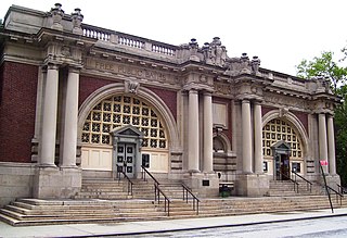
The Department of Parks reconstructed a section of the park from 1934 and 1936, and it reopened on June 25, 1936.[34] In its announcement advertising the park's reopening, the Department of Parks said, "…the reconstructed area will have a large play area with one ball field, handball courts, complete play equipment for small children and a wading pool."[35] A 60-by-100-foot (18 by 30m), $175,000 health center for the middle of the park was proposed in 1935.[36] Its cost later grew to $264,000.[37] The Lower West Side Health Center, as it was called, was built as part of the Public Works Administration.[37] The Health Center Building was opened to the public in July 1937.[37] It was in the eastern part of the park and had a public playground on the roof.[35] The Lower West Side Health Center was one of 8 clinics that were opened in the city that year,[37] out of a total of 30 health centers that had been proposed for the city.[38] At the time of its opening, there were 250,000 people living within the health center's service area.[38]
A proposal to demolish the P.S. 33 building and replace it with an extension of the park was rejected in 1938.[39] The Works Progress Administration (WPA) made further changes to the playground. They added a new area of asphalt in the west of the park, "graded so that it can be flooded for ice-skating when sub-freezing temperatures permit. In season it will be used for roller skating, roller hockey, softball, basketball and other group games."[40] The WPA also built three basketball courts, three handball courts, two courts for pitching horseshoes, and one for skittles.[35][40] This replaced the single baseball diamond that had formerly occupied that portion of the park.[41] The 1940 restoration added floodlights to the softball diamonds.[7] The children's playground was fully equipped with a large wading pool and brick washrooms, while the playground on the roof of the Health Center Building was converted to a sitting area.[40] The WPA-restored park was officially opened on June 6, 1940, in a ceremony attended by Mayor Fiorello H. La Guardia and Parks Commissioner Robert Moses.[35][41] At the time, it was hoped that the existing P.S. 33 structure would be relocated at a future date so the park could be expanded.[40]
Postwar changes (1945–present)
In 1949, the New York City Planning Commission approved a project to add eight new recreation centers citywide, including a $450,000 indoor swimming pool in Chelsea Park,[42] In November 1953, an extension to the park opened on the grounds of P.S.33.[lower-alpha 1] The new additions included two handball courts, three basketball courts, and exercise equipment.[43]
In 1962, plans were announced to build a new post office annex between 28th and 29th Streets, immediately north of the park. The location was occupied by 215 families at the time.[45] A fire in 1967 destroyed the Morgan Post Office Station, one block north of the park between 29th and 30th Streets.[45][46] As of 1977 the park had recently been converted into an tarmac-based "adventure park" with a variety of playground equipment. That year, an environmental impact assessment for the post office annex was conducted.[47] By 1979, the post office station had not been rebuilt, and the block between 28th and 29th Streets had remained undeveloped for over a decade.[45] A postal truck facility planned for that block, which was canceled due to community opposition, was rebuilt at 11th Avenue between 24th and 26th Streets in 1988.[48]
In 1988 the park was well-used from April to November, and the baseball fields were often fully booked. Crime was not a serious problem.[2] The park was being used by homeless people, particularly at the 9th Avenue end, which discouraged the residents of the neighborhood from using that part.[49] An upgrade to the active play equipment in the center portion of the park was planned for the Fall of 1988.[50] In January 1989 a final Environmental Impact Statement (FEIS) was published for a Manhattan General Mail Facility Complex across West 28th Street.[51] As part of the FEIS, upgrades to the park were proposed.[52]
The playground and basketball courts were restored in the mid-1990s.[7] The park was again upgraded in the decade leading up to 2016, but the six handball courts remained dilapidated. The New York City Parks Department, supported by the Fairway Community Foundation, finished refurbishment of the handball courts in 2016. Holes in the walls were patched up and the walls were repainted. The city spent $127,000 on renovations of Chelsea Park as well as at Coffey Park in Red Hook, Brooklyn. Parks Department Commissioner Mitchell Silver was present at a ribbon-cutting ceremony for the handball courts in August 2016.[53]
Notes
↑ A New York Times report and a press release from NYC Parks in November 1953 both announced the opening of the annex on that date.[43][44] However, a more recent NYC Parks webpage says the extension on the grounds of P.S.33 opened in 1952.[7]
Wingate, Jennifer (Summer 2005), "Over the Top: The Doughboy in World War I Memorials and Visual Culture", American Art, 19 (2), The University of Chicago Press on behalf of the Smithsonian American Art Museum: 26–47, doi:10.1086/444480, JSTOR10.1086/444480, S2CID160892950
Riverside Park is a scenic public park on the waterfront of the Upper West Side, Morningside Heights, and Hamilton Heights neighborhoods of the borough of Manhattan in New York City. The park measures 4 miles (6.4 km) long and 100 to 500 feet wide, running between the Hudson River and Henry Hudson Parkway to the west and the serpentine Riverside Drive to the east.
Orchard Beach is the only public beach in the New York City borough of the Bronx. The 115-acre (47 ha), 1.1-mile-long (1.8 km) beach is part of Pelham Bay Park and is situated on the western end of Long Island Sound. The beach consists of a 13-section sandy shorefront, a hexagonal-block promenade, and a central pavilion with food stores and specialty shops. The recreational facilities include two playgrounds, two picnic areas, a large parking lot, and 26 courts for basketball, volleyball, and handball. It is operated by the New York City Department of Parks and Recreation.
Highbridge Park is a public park on the western bank of the Harlem River in Washington Heights, Manhattan, New York City. It stretches between 155th Street and Dyckman Street in Upper Manhattan. The park is operated by the New York City Department of Parks and Recreation. The City maintains the southern half of the park, while the northern half is maintained by the non-profit New York Restoration Project. Prominent in the park are the Manhattan end of the High Bridge, the High Bridge Water Tower, and the Highbridge Play Center.
Homecrest is a neighborhood situated in the New York City borough of Brooklyn, sometimes considered as part of Sheepshead Bay. It is bordered by Kings Highway to the north, Avenue X to the south, Coney Island Avenue to the west, and Ocean Avenue to the east.
Alley Pond Park is the second-largest public park in Queens, New York City, occupying 655.3 acres (265.2 ha). The park is bordered to the east by Douglaston, to the west by Bayside, to the north by Little Neck Bay, and to the south by Union Turnpike. The Cross Island Parkway travels north-south through the park, while the Long Island Expressway and Grand Central Parkway travel east-west through the park. The park primarily consists of woodlands south of the Long Island Expressway and meadowlands north of the expressway. It is run and operated by the New York City Department of Parks and Recreation.
Astoria Park is a 59.96-acre (24.26 ha) public park in the Astoria neighborhood of Queens in New York City. The park is situated on the eastern shore of the Hell Gate, a strait of the East River, between Ditmars Boulevard to the north and Hoyt Avenue to the south. The Robert F. Kennedy (Triborough) and Hell Gate Bridges respectively pass over the park's southern and northern sections. Astoria Park contains a playground, a soccer field, a running track, a skate park, and courts for tennis, basketball, and bocce. Astoria Park also includes the Astoria Play Center, which consists of a recreation center and a pool. The park and play center are maintained by the New York City Department of Parks and Recreation.
Travers Park is a 2-acre (8,100 m2) community park and playground in Jackson Heights, Queens, New York City. It is located between 77th and 78th Streets, on the north side of 34th Avenue. More than half of the park is occupied by an asphalt play area, with basketball and tennis courts. A children's playground with leaf-and-vine shaped spray shower occupies about one third of the park. There are also restroom facilities, handball courts, a dog run, picnic tables, a bicycle rack, benches, tables, and a lawn. In 2012, a segment of adjacent 78th Street was transformed into a permanent Street Plaza; the sports area of a nearby school was also bought by New York City and added to the park.
St. Nicholas Park is a public park in Manhattan, New York City, between the neighborhoods of Harlem, Hamilton Heights and Manhattanville. The nearly 23-acre (93,000 m2) park is contained by 141st Street to the north, 128th Street to the south, St. Nicholas Terrace to the west, and St. Nicholas Avenue to the east.
Crotona Park is a public park in the South Bronx in New York City, covering 127.5 acres (51.6 ha). The park is bounded by streets of the same name on its northern, eastern, southern, and western borders, and is adjacent to the Crotona Park East and Morrisania neighborhoods of the Bronx. It is divided into four portions by Claremont Parkway and Crotona Avenue, which run through it.
DeWitt Clinton Park is a 5.8-acre (23,000 m2) New York City public park in the Hell's Kitchen neighborhood of Manhattan, New York City, between West 52nd and 54th Streets, and Eleventh and Twelfth Avenues.
Jews comprise approximately 10% of New York City's population, making the Jewish community the largest in the world outside of Israel. As of 2020, over 960,000 Jews lived in the five boroughs of New York City, and over 1.9million Jews lived in the New York metropolitan area, approximately 25% of the American Jewish population.
Hamilton Fish Park is a public park in the Lower East Side neighborhood of Manhattan in New York City. The park encompasses two blocks bounded by Houston, Pitt, Sheriff, and Stanton Streets. It contains a playground, basketball courts, and an outdoor swimming complex with general swimming and wading pools. Hamilton Fish Park also includes a Beaux-Arts recreation center designed by Carrère and Hastings. It is maintained by the New York City Department of Parks and Recreation.
The Asser Levy Recreation Center is a recreational facility in the Kips Bay neighborhood of Manhattan in New York City, composed of the Asser Levy Public Baths and Asser Levy Playground. It is bounded by East 23rd Street to the south, East 25th Street to the north, and FDR Drive to the east. Along with the former Asser Levy Place to the west, it was named after Asser Levy, one of New York City's first Jewish citizens and a strong and influential advocate for civil liberties.
St. Mary's Park is a public park in the Mott Haven neighborhood in the South Bronx section of the Bronx, New York City. The park has sporting facilities and an indoor recreation center.
Jackie Robinson Park is a public park in the Hamilton Heights and Harlem neighborhoods of Manhattan in New York City. The approximately 12.77-acre (5.17 ha) park is bounded by Bradhurst Avenue to the east, 155th Street to the north, Edgecombe Avenue to the west, and 145th Street to the south. The park has baseball fields, basketball courts, restrooms, and a bandshell, which are arranged around the park's steep terrain. It also includes the Jackie Robinson Play Center, which consists of a recreation center and a pool. Jackie Robinson Park is maintained by the New York City Department of Parks and Recreation.
Sunset Park is a 24.5-acre (9.9 ha) public park in the neighborhood of Sunset Park, Brooklyn, New York City, between 41st and 44th Streets and 5th and 7th Avenues. The modern-day park contains a playground, recreation center, and pool. The recreation center and pool comprise the Sunset Play Center, which was designated as both an exterior and interior landmark by the New York City Landmarks Preservation Commission. The park is operated by the New York City Department of Parks and Recreation, also known as NYC Parks.
Betsy Head Park is a 10.55-acre (4.27 ha) public park in the Brownsville neighborhood of Brooklyn in New York City. The park occupies two non-contiguous plots diagonally across from each other at the intersection of Dumont Avenue and Thomas S. Boyland Street, covering a collective 10.55 acres (4.27 ha). The modern-day park contains a playground, a swimming complex, and fields for baseball, football, tennis, and basketball. The park's swimming complex, the Betsy Head Play Center, was designed by Ely Jacques Kahn and consists of a bathhouse, a general swimming pool, and an infilled diving pool. The park is operated by the New York City Department of Parks and Recreation, also known as NYC Parks.
Calvert Vaux Park is an 85.53-acre (34.61 ha) public park in Gravesend, Brooklyn, in New York City. Created in 1934, it is composed of several disconnected sections along the Belt Parkway between Bay 44th and Bay 49th Streets. The peninsula upon which the park is located faces southwest into Gravesend Bay, immediately north of the Coney Island Creek. The park was expanded in the 1960s by waste from the construction of the Verrazzano-Narrows Bridge, and was renamed after architect Calvert Vaux in 1998. It is operated by the New York City Department of Parks and Recreation, also known as NYC Parks.
Thomas Jefferson Park is a 15.52-acre (6.28 ha) public park in the East Harlem neighborhood of Manhattan in New York City. The park is on First Avenue between 111th and 114th Streets. It contains a playground as well as facilities for baseball, basketball, football, handball, running, skating, and soccer. The Thomas Jefferson Play Center within the park consists of a recreation center and a pool. The park and play center, named for former U.S. president Thomas Jefferson, are maintained by the New York City Department of Parks and Recreation.
This page is based on this Wikipedia article Text is available under the CC BY-SA 4.0 license; additional terms may apply. Images, videos and audio are available under their respective licenses.