Related Research Articles

Isle of Meadows is a 100-acre (0.40 km2) uninhabited island in the New York City borough of Staten Island in the United States. It is located along the western side of Staten Island, where Fresh Kills empties into the Arthur Kill. The island is owned by the city of New York. It is now a nature preserve providing important meadow and salt marsh nesting habitat for herons, ibises, and egrets, and is not open to the public.
Clay Pit Ponds State Park Preserve is 265-acre (1.07 km2) state park located near the southwestern shore of Staten Island, New York. It is the only state park located on Staten Island.

The Folsom Lake State Recreation Area surrounds Folsom Lake in the foothills of the Sierra Nevada, and is managed by the California Department of Parks and Recreation. It is located near the city of Folsom, California, about 25 miles (40 km) east of Sacramento.

Lemon Creek is a stream located on the South Shore of Staten Island in New York City. It is one of the few remaining ground-level creeks in New York City.

Forest Park is a park in the New York City borough of Queens, spanning 538 acres (218 ha). It is the tenth-largest park in New York City and the third-largest in Queens. Created on August 9, 1895, it was originally referred to as Brooklyn Forest Park, as the area was part of Brooklyn at the time.
Summit Metro Parks is a Metroparks system serving the citizens of Summit County, Ohio by managing 14,000 acres (5,700 ha) in 16 developed parks, six conservation areas and more than 150 miles (240 km) of trails, with 22.4 miles (36.0 km) of the Ohio & Erie Canal Towpath Trail.
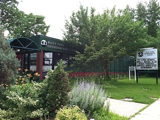
Alley Pond Park is the second-largest public park in Queens, New York City, occupying 655.3 acres (265.2 ha). The park is bordered to the east by Douglaston, to the west by Bayside, to the north by Little Neck Bay, and to the south by Union Turnpike. The Cross Island Parkway travels north-south through the park, while the Long Island Expressway and Grand Central Parkway travel east-west through the park. The park primarily consists of woodlands south of the Long Island Expressway and meadowlands north of the expressway. It is run and operated by the New York City Department of Parks and Recreation.

Green Cay Wetlands is a nature preserve located in Boynton Beach, Florida. The 100-acre (0.40 km2) property was purchased in 1999 from Ted and Trudy Winsberg, who used the property for farming. The Winsbergs sold the property for 1/3 of its appraised value with the condition that it would be made into a wetland. Construction began in July 2003. It was created jointly by the Palm Beach County Utilities Department and the Palm Beach County Parks and Recreation Department in 2004. This park includes 1.5 miles (2.4 km) of an elevated wooden boardwalk, which takes visitors through various habitats, including cabbage palm hammock, cypress swamp, wetland hammock, and tropical hardwood hammock. The boardwalk also features a Seminole chickee hut as well as several gazebos, which have descriptive signs offering information on the wildlife and plant life.

The Wakodahatchee Wetlands is a park located in Delray Beach, Florida. The park was created on 50 acres (20 ha) of unused utility land and transformed into a recreation wetlands open to the public with a three-quarter mile boardwalk that crosses between open water pond areas, emergent marsh areas, shallow shelves, and islands with shrubs and snags to foster nesting and roosting. The boardwalk has interpretive signage as well as gazebos with benches along the way. This site is part of the South section of the Great Florida Birding Trail and offers many opportunities to observe birds in their natural habitats.
Kickapoo State Recreation Area is an Illinois state park on 2,842 acres (1,150 ha) in Vermilion County, Illinois, United States. Located between Oakwood, Illinois and Danville, Illinois, this park is easily accessible through route I-74. It is 28 miles (45 km) away from the University of Illinois at Urbana-Champaign and 95 miles (153 km) from Indianapolis. According to the Illinois Department of Natural Resources, the name Kickapoo originated from the Kickapoo village that once existed near the junction of the Salt Fork and Middle Fork branches of the Vermilion River. After Europeans settled in the area and displaced the Native Americans, the Europeans began to dig wells to harvest salt from salt springs, called salines. In the early 20th century the land was then strip-mined for coal. Kickapoo State Park was the first park in the United States to be located on strip-mined land. The state of Illinois purchased the Kickapoo State Park Area in 1939 with donation money from Danville residents and the land has since recovered from the extraction of these resources.

Noble Woods Park is a wooded city park in Hillsboro, Oregon, United States. Located on approximately 40 acres (160,000 m2) along Rock Creek, the nature park with wetlands and forests is situated between West Baseline Road on the north and Southwest Borwick Road to the south near the Orenco neighborhood. The city acquired the land for the park in 1992 and opened the park in the eastern section of the city in 1998. Noble Woods has two entrances, a picnic area, and hiking trails.
Long Pond Park is a park preserve on the South Shore of Staten Island, New York City. It is approximately 115 acres (0.47 km2) in size and consists mainly of woodlands and wetlands that surround Long Pond, for which the park is named. Long Pond Park is roughly bounded by Hylan Boulevard on the south, Page Avenue on the west, Amboy Road on the north, and Richard Avenue on the east. It is an important stopping point for migrating birds in the Atlantic Flyway.

Vedanthangal Bird Sanctuary is a 30-hectare (74-acre) protected area located in the Madurantakam taluk of the Chengalpattu District in the state of Tamil Nadu, India. The sanctuary is about 75 kilometres (47 mi) from Chennai on National Highway 45 ([NH45]). It is easily reachable from Madurantakam and Chengalpattu. More than 40,000 birds, from various parts of the world visit the sanctuary during the migratory season every year. Vedanthangal is home to migratory birds such as pintail, garganey, grey wagtail, blue-winged teal, common sandpiper and the like. It has been designated as a protected Ramsar site since 2022.

Clove Lakes Park is a public park in the Sunnyside neighborhood of Staten Island in New York City.

Willowbrook Park is a recreational park in Willowbrook, Staten Island, New York City, within the Staten Island Greenbelt. The 164-acre (0.66 km2) public park provides baseball fields, a playground, and a pond. A carousel was opened in 1999. The former Staten Island Hotel can be seen from the park.
The William T. Davis Wildlife Refuge (WTDWR) is an 814-acre (3.29 km2) wildlife refuge straddling the New Springville and Travis sections of Staten Island. The park was named in honor of Staten Island native William T. Davis, a renowned naturalist and entomologist who along with the Audubon Society started the refuge with an original acquisition of 52 acres (210,000 m2). Additional acreage was acquired in increments and the park is today 814 acres (3.29 km2). Beginning in 2010, the adjacent 223-acre (0.90 km2) North Park section of Freshkills Park has undergone preparation to serve as an expansion of the wildlife refuge.

Mount Loretto Unique Area is an open space reserve and nature preserve administered by the New York State Department of Environmental Conservation on the South Shore of Staten Island, New York City. The area's total size is 241 acres (98 ha), of which 49 acres (20 ha) is underwater.
Baisley Pond Park is a public park located in the southeastern part of Queens, New York City, bordering the neighborhoods of South Jamaica, Rochdale, and St. Albans. It covers 109.61 acres (44.36 ha), including the 30-acre (12 ha) Baisley Pond in the center of the park. It is maintained by the New York City Department of Parks and Recreation.
The Fort Worth Nature Center & Refuge (FWNC&R) is a nature center located between Lakeside and Lake Worth, Texas within Fort Worth, Texas city limits. It consists of prairies, forests, and wetlands. The nature center offers a glimpse of what the Dallas–Fort Worth metroplex looked like before settlement. FWNC&R covers 3,621 acres (1,465 ha) and includes over 20 miles (32 km) of hiking trails. It is one of the largest city-owned nature centers in the United States.
References
- ↑ "Blue Heron Park". New York City Department of Parks & Recreation.