
Lemon Creek is a stream located on the South Shore of Staten Island in New York City. It is one of the few remaining ground-level creeks in New York City.
Lemon Creek is a stream located on the South Shore of Staten Island in New York City. It is one of the few remaining ground-level creeks in New York City.

Lemon Creek emerges from a conduit under Rossville Avenue [1] and flows into Porzio's Pond, located north of the intersection of Woodrow Road and Maguire Avenue. [2] Water from the pond reaches Lemon Creek both above ground and underground. [3] Flowing generally southward, near the intersection of Drumgoole Road West and Maguire Avenue, Sandy Brook empties into the creek. This small stream now originates just south of Sharrotts Road and east of the West Shore Expressway. Lemon Creek continues southward under the Korean War Veterans Parkway and Drumgoole Roads, and begins to widen among marshes south of the Staten Island Railway. The creek turns eastward and passes under Bayview Avenue, then southward again. Just above its mouth, it receives a tributary from the east draining Wolfe's Pond, which is located within a city park of the same name. A marina and boat moorings are located here. Immediately below, it empties into Prince's Bay, part of Raritan Bay, just off the corner of Bayview Avenue and Johnston Terrace.
Throughout its above-ground length, Lemon Creek is generally regarded as the boundary between the neighborhoods of Prince's Bay and Pleasant Plains on Staten Island's South Shore. Its watershed covers about 2 square miles (5.2 km2) [4] and lies within the terminal moraine crossing Staten Island. [5] The lower reaches of the creek, below the Staten Island Railway, are bordered by extensive marshes, the largest and most pristine on the south shore of Staten Island. [3] This area includes both salt marsh and the only tidal freshwater marsh on Staten Island. [4]
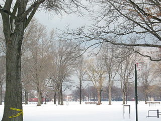
Much of the creek below Hylan Boulevard, and a long strip of shoreline to the west, is part of the 105.77 acres (42.80 hectares) Lemon Creek Park, established in 1962. The park includes the Seguine Mansion. [6] The northern, wooded portion of the park forms the 15.99 acres (6.47 hectares) Lemon Creek Park Preserve. [3] Wolfe's Pond and its source, Wolfe Brook, comprise the 341.33 acres (138.13 hectares) Wolfe's Pond Park. [7] The upper reaches of Lemon Creek, and most of Sandy Brook flow through Bloomingdale Park, 138.67 acres (56.12 hectares). [8]
The creek first appears in recorded history in 1670, as one of the boundaries of a 140-acre (56.7 ha) grant of land to Paulus Regrenier. The Abraham Manee Homestead may encompass Regrenier's original dwelling. [9]
Clams were once abundant at the mouth of the creek, in Prince's Bay. [10] The oysters harvested there were once a delicacy exported to London, [6] and the export of oysters helped make the fortune of the local Seguine family. [9] However, shellfishing ceased in the area in the 1920s due to an outbreak of typhoid fever traced to Raritan Bay oysters. However, while non-commercial clamming is still forbidden due to pollution, commercial clamming is permitted if the clams are transplanted into clean water before harvest, and the Lemon Creek marina is again a base for clamming vessels. [11]

Known in 1830 as Seguine's Creek for the Seguine family, this body of water was referred to as the Little North River by 1895. Shortly thereafter, it began to be called Lemon Creek, although the origin of the name is not known. [6]
The marshes along the lower creek provide a home for waterfowl such as swans, mallards, and black ducks, and a refuge for migrating birds, as well as monarch butterflies. [6] Lemon Creek Park is also home to the only purple martin colony in New York City, [4] [12] popular among local birdwatchers. [13]
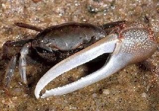
In the center of the marshes on the lower creek is Ziel's Island, also known as Crab Island for the fiddler crabs and blue crabs that live there. [12] Clams are commercially harvested off the mouth of the creek, and various marine fish can be caught from a fishing pier at the mouth of the creek. [3]

Raritan Bay is a bay located at the southern portion of Lower New York Bay between the U.S. states of New York and New Jersey and is part of the New York Bight. The bay is bounded on the northwest by New York's Staten Island, on the west by Perth Amboy, New Jersey, on the south by the Raritan Bayshore communities in the New Jersey counties of Middlesex and Monmouth, and on the east by Sandy Hook Bay. The bay is named after the Raritans, a branch of the Lenape tribe who lived in the vicinity of the bay and its river for thousands of years, prior to the arrival of Dutch and English colonists in the 17th century.

The South Shore is a geographical term applied to the area in the New York City borough of Staten Island, south and east of the island's ridge of hills along the waterfront and adjacent areas from the Narrows to the mouth of the Arthur Kill. Many observers prefer to restrict its scope to the neighborhoods located between the shoreline of Raritan Bay on one side and Richmond Creek and Fresh Kills on the other, thus encompassing the neighborhoods of Great Kills to Tottenville only. Those who use this narrower definition of the "South Shore" prefer the term "East Shore" for the communities that lie along Lower New York Bay, and inland for approximately 2 to 2+1⁄2 miles, from Bay Terrace and Richmondtown to as far north as Grasmere and Concord. The South Shore is represented in the New York City Council by Joe Borelli.

Barnegat Bay is a small brackish arm of the Atlantic Ocean, approximately 42 miles (68 km) long, along the coast of Ocean County, New Jersey in the United States. It is separated from the Atlantic by the long Island Beach State Park, as well as by the north end of Long Beach Island, popular segments of the Jersey Shore. The bay is fed by several small rivers, including the Toms River, the Forked River, the Metedeconk River, Cedar Creek, Oyster Creek, Mill Creek, Westecunk Creek, and Tuckerton Creek, all of which empty into the bay through small estuaries along its inner shore. The communities of Toms River, Silverton, and Forked River sit along the river estuaries on the bay.
Prince's Bay is the name of a neighborhood located on the South Shore of New York City's borough of Staten Island. Prince's Bay is bordered to the north by Huguenot, to the south by the Raritan Bay, and to the west by Pleasant Plains. The neighborhood is represented in the New York State Senate by Andrew Lanza, in the New York State Assembly by Michael Reilly, and in the New York City Council by Joe Borelli.

The Korean War Veterans Parkway is a parkway that traverses the South Shore of Staten Island, New York, in the United States. It begins at NY 440 near the Outerbridge Crossing and runs from southwest to northeast to a merge with Drumgoole Road in the island's Greenridge section. The parkway is designated New York State Route 909C (NY 909C), an unsigned reference route, which continues northeast along Drumgoole Road for a short distance to its end at an intersection with Richmond Avenue.

Annadale is a middle-class neighborhood on the South Shore of the borough of Staten Island in New York City.

Pleasant Plains is a neighborhood located on Staten Island, New York City, New York. It is bordered by Woodrow to the north, the Lower New York Bay to the south, Richmond Valley to the west, and Prince's Bay to the east. The neighborhood is represented in the New York City Council by Joe Borelli.

Woodrow is a neighborhood located on the South Shore of Staten Island, New York, United States. The neighborhood is represented in the New York State Senate by Andrew Lanza, in the New York State Assembly by Michael Reilly, and in the New York City Council by Joe Borelli.
Marine Park is a public park located in the neighborhood of Marine Park in Brooklyn, New York. Its 798 acres (3.2 km2) surround the westernmost inlet of Jamaica Bay. Most of the land for Marine Park was donated to New York City to be turned into public park land by the Whitney family in 1920 and by Frederic B. Pratt and Alfred Tredway White, who jointly donated 150 acres (0.61 km2) in 1917. The land donated consists of the area between the current day Fillmore Avenue and Gerritsen Avenue and East 38th Street. Originally almost 2,000 acres (810 ha), over half of which has been donated to the National Park Service as part of the Gateway National Recreation Area, the park is mainly a fertile salt marsh which is supplied with freshwater from Gerritsen Creek.
Richardson Bay is a shallow, ecologically rich arm of San Francisco Bay, managed under a Joint Powers Agency of four northern California cities. The 911-acre (369 ha) Richardson Bay Sanctuary was acquired in the early 1960s by the National Audubon Society. The bay was named for William A. Richardson, early 19th century sea captain and builder in San Francisco. It contains both Strawberry Spit and Aramburu Island.

The Prince's Bay station is a Staten Island Railway station in the neighborhood of Prince's Bay, Staten Island, New York.

Bloomingdale Park is a 138-acre (56 ha) park on the South Shore of Staten Island. It is located in the Prince's Bay neighborhood, and is bounded on the north by Ramona Avenue, on the west by Bloomingdale Road, on the east by Lenevar Avenue, and on the south by Drumgoole Road West and the Korean War Veterans Parkway. It is nearly bisected by Maguire Avenue, but the avenue's two spurs into the park from the north and south do not meet in the middle.

Wolfes Pond Park is a large public park located on Staten Island's South Shore. It is bounded on the south by Holton Avenue, on the east by Raritan Bay, on the west by the Staten Island Railway, and on the north by Chisholm Street, Luten Avenue, and Cornelia Avenue, which is also the main entry into the park's public areas. Hylan Boulevard bisects the park, and most visitors only visit the eastern half of the park, where Wolfes Pond, two playgrounds, and basketball and tennis courts are located, as well as numerous walking and biking paths, open fields, and a small beach on Raritan Bay. The western, inland half consists mostly of ponds and woodlands, and the northwestern corner hugs Tottenville High School.

The Abraham Manee House, also known as the Manee-Seguine Homestead, is a three-part Colonial Dutch dwelling in Prince's Bay on Staten Island in New York City, New York, U.S. It was designated a New York City landmark in 1984. Located on Purdy Place adjacent to Lemon Creek, on the South Shore of Staten Island, the oldest section is a one-room structure built by Paulus Regrenier in 1670, a French Huguenot fleeing religious persecution in Europe. The building is similar to the Billiou-Stillwell-Perine House in Old Town.

The Seguine Mansion, also known as the Seguine-Burke Mansion, is located on Lemon Creek near the southern shore of Staten Island, New York City. The Greek Revival house is one of the few surviving examples of 19th-century life on Staten Island. It is listed on the National Register of Historic Places and is a member of the Historic House Trust.
Little Neck Bay is an embayment in western Long Island, New York, off Long Island Sound. Little Neck Bay forms the western boundary of the Great Neck Peninsula, the eastern boundary of which is Manhasset Bay. The political boundary between Nassau County and the borough of Queens runs through the bay, bordering the neighborhood of Douglaston–Little Neck.
The William T. Davis Wildlife Refuge (WTDWR) is an 814-acre (3.29 km2) wildlife refuge straddling the New Springville and Travis sections of Staten Island. The park was named in honor of Staten Island native William T. Davis, a renowned naturalist and entomologist who along with the Audubon Society started the refuge with an original acquisition of 52 acres (210,000 m2). Additional acreage was acquired in increments and the park is today 814 acres (3.29 km2). Beginning in 2010, the adjacent 223-acre (0.90 km2) North Park section of Freshkills Park has undergone preparation to serve as an expansion of the wildlife refuge.

Mount Loretto Unique Area is an open space reserve and nature preserve administered by the New York State Department of Environmental Conservation on the South Shore of Staten Island, New York City. The area's total size is 241 acres (98 ha), of which 49 acres (20 ha) is underwater.

Theodore Roosevelt State Natural Area is a 265-acre (1.07 km2) North Carolina state park in Carteret County, North Carolina, in the United States. Located on Bogue Banks, in the town of Pine Knoll Shores, the natural area protects the barrier island's only remaining intact maritime forest. It is bounded by NC 58 to the south, Bogue Sound to the north, and private development to the east and west.