Sanitary & Topographical Map of the City and Island of New York (1865) by Egbert Ludovicus Viele shows the path of Minetta Creek with the then-current street grid superimposed.
Minetta Creek was one of the largest natural watercourses in Manhattan, New York City, United States. Minetta Creek was fed from two tributaries, one originating at Fifth Avenue and 21st Street, and the other originating at Sixth Avenue and 16th Street. They joined near Fifth Avenue and 11th Street then took a southwesterly course. Minetta Creek's name is thought to have originated from either the Native American term "Manette", meaning "Devil's Water", or the Dutch word "Minnetje", meaning "the little one".
Minetta Creek was originally known by the Dutch as Bestevaer's Killetje. During the 18th century, large amounts of wildlife could be seen around the creek. In the early 1820s, the New York City common council commissioned a project to divert Minetta Creek into a covered sewer. The creek was filled in by the mid-19th century, although it persisted as an underground stream through the 20th century.
Ever since the creek was covered in the 19th century, there have been debates over whether the creek still exists. Minetta Creek caused flooding in basements and construction sites from the mid-19th century through the mid-20th century. Pools of water were also found at several construction sites along the creek's course.
Course
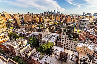
Minetta Creek was one of Manhattan's largest natural waterways.[3] Nearly 2 miles (3.2km) long, Minetta Creek began from two tributaries, the main one having its source[lower-alpha 1] near Fifth Avenue and 21st Street, and a secondary one that had its source at Sixth Avenue and 16th Street.[4] The streams flowed southward and joined within the block bound by 11th and 12th Streets between Fifth and Sixth Avenues. From there it flowed southward across modern-day Washington Square Park. It then crossed southwest along the present route of Minetta Lane, one of the creek's namesake streets.[5][6] The creek then roughly followed the current path of Minetta Street, a one-block road going south from Minetta Lane before curving southwest to meet Sixth Avenue.[7] Minetta Creek then turned west along what is now Downing Street and eventually discharged into the Hudson River near Charlton Street.[5][6]
Origins of name
Plaque on the building at Two Fifth Avenue in honor of Minetta Creek
Minetta Creek is alternatively called Minetta Brook, Minetta Stream, Minetta Water,[6] or Minetta Waters.[8] It was also referred to by its Dutch name, Bestevaer's Killetje, before the American Revolutionary War.[9] A plaque affixed to the building at Two Fifth Avenue provides one derivation of the "Minetta" name and reads as follows:
Bestevaer's Killetje or Grandfather's Little Creek
For the past two centuries familiar to this neighborhood as
Minetta Brook
Another theory is that the name is an Anglicization of the Dutch root "min" or "minuut" (English: little) and suffix "-tje" to produce "Minnetje" or "The little one" to distinguish it from the Groot Kill, a large creek that was a mile away. However, 'min' in Dutch does not translate to "little"; in modern Dutch, it translates to "minus" or "less".[10]
Colonial days
On a section of Bernard Ratzer's map of New York and its suburbs, made circa 1766, Minetta Creek is labeled "Bestavaer's Rivulet" and may be seen in high resolution, exiting into the Hudson River on the left edge about halfway up in the area labeled, "Abe Mortier Est.,", below Lady Warren's estate
In the Dutch era, the area surrounding the creek was known as the Land of the Blacks and settled by freed Africans. A path along the creek, called the "Negroes' Causeway", later formed the hub of the Little Africa neighborhood and now follows part of the route of Minetta Street.[11][12][13]
The creek, whose course formed a well-defined channel, was known for its abundance of fish, in particular trout.[10][14]Pickerel, bass, and pike were among the species fished in it.[3] "All manner of wild fowl" including ducks and geese could be found in the creek.[3] In fact, the filling-in had preceded real-estate speculators' infill operations, according to the British Headquarters Map of c. 1782–1783. At the time, the British carried out extensive defenses of the city, and according to ecologist Eric W. Sanderson, "they dammed Minetta Water to create a lake in what is now the West Village".[15]
Bestevaer's Killetje formed a convenient landmark designation for surveyors. Murray Hoffman's Treatise Upon the Estate and Rights of the Corporation of the City of New York, as Proprietors reprints numerous historical documents from the seventeenth and eighteenth centuries, a number of which mention Minetta Creek.[16] Most of these pre-nineteenth century documents refer to the creek by its Dutch name, Bestavaer's Killtjie (or, in a more probable spelling, Bestevaer's Killetje). One of the most significant of pre-American Revolutionary War documents consolidating ownership of land in Manhattan was the Montgomerie Charter, named after governor John Montgomerie, dated January 15, 1730, and ratified by the Colonial Legislature in 1732. It stated in part:
...[A]ll that space of ground and soil of the Hudson river, now lying and being under the water of the same river, to begin at a certain place near high water mark at the south end of a piece of upland, which lies between the said river and a piece of meadow ground or marsh, being the first piece of meadow ground or marsh near Hudson river to the southward of Greenwich, and from whence the above named run of water called Bestaver's Killetjie or rivulet runs into Hudson's river, from which place of beginning, to extend or run to the south side of the street which runs from the parade before our fort in New York to the Hudson's river, south eighteen degrees thirty minutes west, on a straight line; the distance being one hundred and twenty-five chains [i.e. 8,250 feet (2,510m) or 1.417 miles (2.280km)], from which line to run a perpendicular breadth of, and to comprehend four hundred feet [120 metres] from low water mark into Hudson's river.[16]
The Land Ordinance of 1796 – a U.S. federal cadastral survey done for purposes of taxation, also reprinted by Hoffman – laid out the line of West Street, which had been built over landfill. The survey took note of three particular locations. The first was a point 150 feet (46m) north of Greenwich Street "from the center of the arch or bridge over Bestaver's Killtjie." Hoffman added a note: "Bestaver's Killtjie was afterward known as the Minetta Brook, and crossed Greenwich street in the vicinity of Charlton Street." He concluded his note by stating that this geographic point was represented in an 1807 map made by Charles Loss.[16]
View of Minetta Street, which is built over the creek. This view looks south at the unusual curve caused by the creek's path
A swamp area existed in what is now Washington Square Park, fed by the waters of Minetta Creek.[8] The creek served as a boundary between a potter's field which was established on April 7, 1797, and was in operation until May 25, 1825, on its eastern bank, and private property to its west.[8]
The southernmost part of the creek's course was the estate known as Richmond Hill, originally created by Abraham Mortier in the late 1760s. In 1794, he leased it to Aaron Burr, who altered the course of the creek to form "Burr's Pond" at the foot of his estate.[17]
Covering
In 1896, Charles Haynes Haswell recalled an observation from eighty years earlier. Minetta Stream had been "fully apparent; and as it was and is of considerable volume, it has been [a] very important and expensive factor in the construction of the foundations along its line, from its main source, near the site of the Union Club, to its discharge in the North [i.e. Hudson] River."[4] "In 1820 there still was a small colony of muskrats, bordering this creek," Issachar Cozzens recalled in 1843. "The brook passed along the lower end of Potter's Field, and formed a large pond called Bollus's Pond, where Downing Street now is; the low swampy grounds that were filled up caused this pond, which lay a little north-west of Richmond Hill."[18]
Street view of 45 West 12th Street (left), whose eastern wall overlaps 43 West 12th Street (right), a result of the former building constructed on the bank of Minetta Creek
The covering of Minetta Stream began in 1820, when the common council appointed James Wallace to build a Minetta sewer. Joan H. Geismar, an urban archaeologist who wrote an archaeological assessment of Washington Square Park in 2005, hypothesized that the purpose of this sewer was in part to function as a drain directing water away from the potter's field.[21] Geismar surmised that the building of the sewer was not enough for the creek to avoid the cemetery because in 1823, the common council directed Thomas Cummings to deepen the riverbed of Minetta Creek.[22] Due to the opening of Fifth Avenue, on December 10, 1824, the Council directed that Minetta Creek be culverted from its location at Fourth Street (now Washington Square South) to Sixth Street (now Washington Square North).[23] With the closing of the potter's field on May 25, 1825, the council chose to transform the area into a military parade ground, which eventually became Washington Square Park. By autumn 1828, the creek was diverted to the Hudson River through a wooden sewer.[24] By 1849, the Richmond Hill estate near the southern end of the stream had been demolished, with row houses taking its place, indicating that water no longer flowed through the area.[25] The residential brownstone residence at 45 West Twelfth Street was built in 1846, with its eastern wall at an odd shape, slightly overlapping its neighbor at 43 West Twelfth Street (erected in 1861). This wall had been necessitated because the house was built on the bank of Minetta Creek.[19]
Egbert Ludovicus Viele, a nineteenth-century expert on Minetta Creek
With increasing numbers of immigrants moving to the area during the latter half of the nineteenth century, several doctors were appointed by the New York State Legislature to investigate housing conditions in tenements, and they spent many days interrogating various residents. On October 27, 1884 they interrogated John F. Attridge, a real estate agent, on living conditions in various kinds of housing in lower Manhattan. At one point Doctor S. Oakley Vanderpoel raised the subject of whether houses built over filled-in ground had proper drainage. To this Attridge responded: "I lived for fifteen years over Minetta Brook, and the people always considered it the most unhealthy place in New York, but there was nobody sick."[26]
In 1892, the New York Times reported the flooding of the cellar of Solomon Sayles, a merchant whose store was located at 126 Sixth Avenue, between Tenth and Eleventh Streets.[3][27] This incident provided the Times's reporter an opportunity to speak with Egbert Ludovicus Viele, who had designed the Topographical & Sanitary Map of Manhattan published in 1865. Viele had first investigated the creek in 1860, using a British survey made at the time of the Revolutionary War.[28][12] Viele explained that the creek was a source of water prior to construction of the Croton Distributing Reservoir. Once the reservoir had been completed in 1842, the creek was no longer needed as a water source, and it became a dumping ground. When Viele once gave a talk on the creek, an elderly physician in the audience recalled cases of intermittent fever due to the creek. Viele was quoted as saying "I have no doubt that the water in Mr. Sayles's cellar comes from the sources of Minetta Creek."[3] He then described the source of Minetta Creek as a perennial spring. Viele concluded that because the springs were natural, dams could not be installed upon them. The 1892 article recommended better drainage for Manhattan's subterranean water sources.[3]
In his 1894 book, In Old New York, Thomas A. Janvier wrote: "Although Manetta Creek no longer is visible on the surface, it still flows in diminished volume through its ancient channel—as those living near or over it sometimes know to their cost."[29] Janvier described the creek's path and warned that no buildings could be built on or near it without extensive reinforcements to their foundations. In addition to Sayles's store, he mentioned the recent floodings of the Lincoln Building at the southwest corner of Union Square, the building at the northeast corner of 19th Street and Fifth Avenue, and 66 Fifth Avenue.[29]
In 1897, George Everett Hill and George E. Waring Jr. wrote: "Although Minetta Brook has been lost to sight for many years, we have abundant evidence that it still exists. Deep excavations near its course are almost invariably flooded by its waters, and heavy buildings over or beside it require elaborate foundations of piling."[14]
Encounters with the creek underground
Encounters with Minetta Creek in the twentieth century were based on construction projects that unexpectedly encountered its water underground. In 1900, construction workers for the Hudson and Manhattan Railroad (H&M; today the PATH) had to navigate quicksand formed from the water. Their work was particularly difficult as they could not break the surface of Sixth Avenue, which would have disrupted traffic.[30] The next year, Egbert Ludovicus Viele was again contacted concerning flooding in a construction project, and again declared the source of water to be Minetta Creek.[31][12]
In 1907, the Degnon Contracting Company was building the H&M Railroad's Uptown Hudson Tubes north of Ninth Street and declared the water to have dried up, to the relief of area property owners who had previously spent thousands of dollars on pumps to rid their properties of water.[32] This was again confirmed by a 1916 article.[33] Subsequently, in 1928, the Independent Subway System's West Fourth Street–Washington Square station (now part of the New York City Subway system) was built under the H&M tunnels. A reporter for The New York Times indicated that the stream could be seen in the construction site.[34]
In 1929, workers at the construction site of Jefferson Market found their worksite filled with water. H. W. Lesh, the chief engineer of contractor Marcus Construction Company, attributed the source to Minetta Creek.[35] A photograph of the site under construction shows a pool of water from the creek.[36] In 1977, during construction on Saint Vincent's Catholic Medical Center, Crimmins Construction encountered water from Minetta Creek. Robert Crimmins reported that the water was "quite clean" and that it flows "through the ground quite rapidly."[37]
The construction of Jimi Hendrix's Electric Lady Studios, in 1968, had been delayed in part due to flooding attributed to Minetta Creek.[38] In 2014, author Rachel Kaadzi Ghansah wrote about a visit to Electric Lady Studios in The Believer, where she saw water from the creek "rushing clear and steady" through a hole in the studio's cellar.[39]
To this day, it is disputed whether Minetta Creek actually exists.[40] Bloggers claim that the creek still exists, based on evidence of flooding in basements and cellars.[41][42][43] Will Hunt, searching in 2011, could not find any evidence of subterranean water.[20] In 2012, local news station WCBS-TV ran a story about several people looking into a manhole on Sixth Avenue, along the creek's former route, where observers found water that "looked too clean for the city sewer". Steve Duncan, a historian and self-described geographer, told WCBS about the presence of potholes on 12th and 13th streets near where the creek crossed these streets, as well as flooding in basements along the creek's route.[44]
Gallery
Examples of Minetta Creek's effect on Manhattan topography
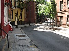
View looking north of Minetta Street which is built on the approximate riverbed of Minetta Creek; Minetta Triangle is on the left
View from Minetta Street looking south across Sixth Avenue at Downing Street; both Minetta Street and Downing Street are built on top of the Minetta Creek riverbed
Upper view of overlap of 45 West 12th Street (at left) over 43 West 12th Street (at right), a result of the former building constructed on the Minetta Creek shoreline
Lower view of overlap of 45 West 12th Street (at left) over 43 West 12th Street (at right), a result of the former building constructed on the Minetta Creek shoreline
Places named for Minetta Creek
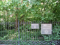
Minetta Triangle, a small park where Minetta Street meets Sixth Avenue
Minetta Green, on Sixth Avenue south of Minetta Lane
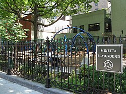
Minetta Playground, on Sixth Avenue between Third and Fourth Streets
Notes
↑ According to Charles Homer Haswell, it is "near the site of the Union Club".[4] The Union Club premises until 1903 were at Fifth Avenue and 21st Street.
Related Research Articles
Greenwich Village, or simply the Village, is a neighborhood on the west side of Lower Manhattan in New York City, bounded by 14th Street to the north, Broadway to the east, Houston Street to the south, and the Hudson River to the west. Greenwich Village also contains several subsections, including the West Village west of Seventh Avenue and the Meatpacking District in the northwest corner of Greenwich Village.
Houston Street is a major east–west thoroughfare in Lower Manhattan in New York City, United States. It runs the full width of the island of Manhattan, from FDR Drive along the East River in the east to the West Side Highway along the Hudson River in the west. The street is divided into west and east sections by Broadway.
The Hackensack River is a river, approximately 45 miles (72 km) long, in the U.S. states of New York and New Jersey, emptying into Newark Bay, a back chamber of New York Harbor. The watershed of the river includes part of the suburban area outside New York City just west of the lower Hudson River, which it roughly parallels, separated from it by the New Jersey Palisades. It also flows through and drains the New Jersey Meadowlands. The lower river, which is navigable as far as the city of Hackensack, is heavily industrialized and forms a commercial extension of Newark Bay.
Spuyten Duyvil Creek is a short tidal estuary in New York City connecting the Hudson River to the Harlem River Ship Canal and then on to the Harlem River. The confluence of the three water bodies separate the island of Manhattan from the Bronx and the rest of the mainland. Once a distinct, turbulent waterway between the Hudson and Harlem rivers, the creek has been subsumed by the modern ship canal.
Canal Street is a major east–west street of over 1 mile (1.6 km) in Lower Manhattan, New York City, United States, running from East Broadway between Essex and Jefferson Streets in the east, to West Street between Watts and Spring Streets in the west. It runs through the neighborhood of Chinatown, and forms the southern boundaries of SoHo and Little Italy as well as the northern boundary of Tribeca. The street acts as a major connector between Jersey City, New Jersey, via the Holland Tunnel (I-78), and Brooklyn in New York City via the Manhattan Bridge. It is a two-way street for most of its length, with two unidirectional stretches between Forsyth Street and the Manhattan Bridge.
Sixth Avenue, also known as Avenue of the Americas, is a major thoroughfare in New York City's borough of Manhattan, on which traffic runs northbound, or "uptown". It is commercial for much of its length.
The Croton Aqueduct or Old Croton Aqueduct was a large and complex water distribution system constructed for New York City between 1837 and 1842. The great aqueducts, which were among the first in the United States, carried water by gravity 41 miles (66 km) from the Croton River in Westchester County to reservoirs in Manhattan. It was built because local water resources had become polluted and inadequate for the growing population of the city. Although the aqueduct was largely superseded by the New Croton Aqueduct, which was built in 1890, the Old Croton Aqueduct remained in service until 1955.
Ninth Street station is a station on the PATH system. Located at the intersection of 9th Street and Sixth Avenue in the Greenwich Village neighborhood of Manhattan, New York City, it is served by the Hoboken–33rd Street and Journal Square–33rd Street lines on weekdays, and by the Journal Square–33rd Street line on weekends.
The West Village is a neighborhood in the western section of the larger Greenwich Village neighborhood of Lower Manhattan, New York City. The West Village is bounded by the Hudson River to the west and 14th Street to the north. The eastern boundary is variously cited as Greenwich Avenue, Seventh Avenue, or Sixth Avenue, while the southern boundary is either Houston Street or Christopher Street.
The West Fourth Street–Washington Square station is an express station and transfer stop on the IND Sixth Avenue and IND Eighth Avenue Lines of the New York City Subway, located at the intersection of West Fourth Street and Sixth Avenue in Greenwich Village, Manhattan. It is served by the A, D, E, and F trains at all times; the B and M trains on weekdays; the C train at all times except late nights; and the <F> train during rush hours in the peak direction.
Hangman's Elm, or simply "The Hanging Tree", is an English Elm located at the northwest corner in Washington Square Park in Greenwich Village, Manhattan, New York City. It stood at 135 feet (41 m) tall when measured c. 2000, and has a diameter of 67 inches (1.7 m).
The Uptown Hudson Tubes are a pair of tunnels that carry PATH trains between Manhattan, New York City, to the east and Jersey City, New Jersey, to the west. The tubes originate at a junction of two PATH lines on the New Jersey shore and cross eastward under the Hudson River. On the Manhattan side, the tubes run mostly underneath Christopher Street and Sixth Avenue, making four intermediate stops before terminating at 33rd Street station. The tubes do not enter Uptown Manhattan; the name reflects their location north of the Downtown Hudson Tubes that connect Jersey City and the World Trade Center.
Greenwich Street is a north–south street in the New York City borough of Manhattan. It extends from the intersection of Ninth Avenue and Gansevoort Street in the Meatpacking District at its northernmost end to its southern end at Battery Park. Greenwich Street runs through the Meatpacking District, the West Village, Hudson Square, and Tribeca.
The Sawkill or Saw-kill was the largest hydrological network on Manhattan island in New York City before the Dutch colony of New Netherland was founded in 1624. This 44,980-foot-long (13,710 m) stream began "within four blocks of the Hudson River":
A rill flowing east from the rocky ridge overlooking Bloomingdale Village, which rose near Ninth Avenue and 85th Street, flowed in a southerly direction through Manhattan Square, where it spread into a little pond, and then turned east, crossing Central Park to Fifth Avenue, receiving three tributaries within its limits, two from the north and one from the south. At 75th Street near Third Avenue it was joined by another stream. Near this junction the old Boston Post Road crossed it, and then from this point, the stream ran due east to its outlet near the foot of 75th Street
14th Street is a major crosstown street in the New York City borough of Manhattan, traveling between Eleventh Avenue on Manhattan's West Side and Avenue C on Manhattan's East Side. It forms a boundary between several neighborhoods and is sometimes considered the border between Lower Manhattan and Midtown Manhattan.
The Charlton–King–Vandam Historic District is a small historic district in Lower Manhattan, New York City. Designated by the New York City Landmarks Preservation Commission (NYCLPC) in 1966, the district contains "the city's largest concentration of row houses in the Federal style, as well as a significant concentration of Greek Revival houses." It is sometimes included as part of the South Village or Hudson Square, though it is historically distinct from both neighborhoods.
Kissena Creek is a buried stream located in the neighborhoods of Flushing, Fresh Meadows, Hillcrest, and Kew Gardens Hills in the New York City borough of Queens. Kissena Creek originates in a now-filled swamp within Kew Gardens Hills and Pomonok in central Queens, flowing east to Hillcrest. The creek then travels mostly north and west, largely flowing beneath Kissena Park Golf Course, Kissena Park, Kissena Corridor Park, and Queens Botanical Garden, before merging with the Flushing River in Flushing Meadows–Corona Park.
Tibbetts Brook, originally Tippett's Brook or Tibbitt's Brook, is a stream in the southern portion of mainland New York, flowing north to south from the city of Yonkers in Westchester County into the borough of the Bronx within New York City. Originally emptying into Spuyten Duyvil Creek as part of the Harlem River system, the stream is now partially subterranean, ending above ground at the south end of Van Cortlandt Lake within Van Cortlandt Park. There it proceeds into city sewers, draining into either the northern end of the Harlem River or the Wards Island Water Pollution Control Plant. The brook provides significant watershed to both Van Cortlandt Park at its south end and Tibbetts Brook Park at its north end. There have been modern proposals to daylight the southern portion of the brook back onto the surface.
Subterranean New York City relates to the area beneath the surface level of New York City; the natural features, man-made structures, spaces, objects, and cultural creation and experience. Like other subterranea, the underground world of New York City has been the basis of TV series, documentaries, artwork, and books.
↑ Callahan, Jennifer (January 30, 2005). "Minetta Moments". The New York Times. ISSN0362-4331. Archived from the original on July 31, 2024. Retrieved December 13, 2018.
↑ Geismar 2005, p.28. Geismar expresses some doubt as to whether this plan was ever carried out, although she warns of uncovering the wooden culvert on p. 39 and provides a schematic of its approximate location on p. 42.
↑ "Testimony taken by the commissioners appointed by an act of the Legislature to investigate the character and condition of tenement houses and their occupants in the city of New York," Documents of the Senate of the State of New York, One Hundred and Eighth Session, 1885, volume 5 (Albany, NY: Weed, Parsons and Company, 1885), p. 125.
↑ New York City Directory, 1890, available on Ancestry.com, accessed July 8, 2012.
↑ The British Headquarters Map, c 1782–83 formed the starting-point for the Mannahatta Project, which resulted in the exhibition "Mannahatta" at the Museum of the City of New York (2009) and the companion volume edited by Eric W. Sanderson, 2009.
↑ "Who Stole the Creek?"(PDF). New York Tribune. September 13, 1907. p.5. Archived(PDF) from the original on December 31, 2021. Retrieved February 13, 2018– via Fultonhistory.com.
↑ Nicholson, Arthur T. (August 20, 1916). "Above the Foundation"(PDF). New York Tribune. p.B6. Archived(PDF) from the original on July 31, 2024. Retrieved February 13, 2018– via Fultonhistory.com.
↑ "The Sun's Rays: Old Minetta Might Purl Again," New York Sun (December 21, 1928).
↑ Ghansah, Rachel Kaadzi (January 1, 2015). "A River Runs Through It". The Believer. 13 (1). Archived from the original on March 8, 2016. Retrieved January 14, 2015.
This page is based on this Wikipedia article Text is available under the CC BY-SA 4.0 license; additional terms may apply. Images, videos and audio are available under their respective licenses.