
Queens is a borough of New York City, coextensive with Queens County, in the U.S. state of New York. Located on Long Island, it is the largest New York City borough by area. It is bordered by the borough of Brooklyn at the western tip of Long Island, and Nassau County to its east. Queens shares water borders with the boroughs of Manhattan, the Bronx, and Staten Island.

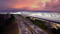
LaGuardia Airport is a civil airport in East Elmhurst, Queens, New York City. Covering 680 acres as of January 1, 2023, the facility was established in 1929 and began operating as a public airport in 1939. It is named after former New York City mayor Fiorello La Guardia.

The New York–New Jersey Harbor Estuary, also known as the Hudson-Raritan Estuary, is in the northeastern states of New Jersey and New York on the East Coast of the United States. The system of waterways of the Port of New York and New Jersey forms one of the most intricate natural harbors in the world and one of the busiest ports of the United States. The harbor opens onto the New York Bight in the Atlantic Ocean to the southeast and Long Island Sound to the northeast.

The San Francisco Public Utilities Commission (SFPUC) is a public agency of the City and County of San Francisco that provides water, wastewater, and electric power services to the city and an additional 1.9 million customers within three San Francisco Bay Area counties.

The Marine Air Terminal is an airport terminal located at LaGuardia Airport in Queens, New York City. Its main building, designed in the Art Deco style by William Delano of the firm Delano & Aldrich, opened in 1940. The terminal was built to handle Pan Am's fleet of flying boats, the Boeing 314 Clippers, which landed on the nearby Bowery Bay. Technological advances after World War II made the Clippers obsolete, and the Marine Air Terminal was renovated in 1946 to serve conventional planes. As of 2022, the terminal is used by Spirit Airlines flights to various destinations around the US.

Newtown Creek, a 3.5-mile (6-kilometer) long tributary of the East River, is an estuary that forms part of the border between the boroughs of Brooklyn and Queens, in New York City. Channelization made it one of the most heavily-used bodies of water in the Port of New York and New Jersey and thus one of the most polluted industrial sites in the United States, containing years of discarded toxins, an estimated 30,000,000 US gallons of spilled oil, including the Greenpoint oil spill, raw sewage from New York City’s sewer system, and other accumulation from a total of 1,491 sites.

East Elmhurst is a residential neighborhood in the northwest section of the New York City borough of Queens. It is bounded to the south by Jackson Heights and Corona, to the north and east by Bowery Bay, and to the west by Woodside and Ditmars Steinway. The area also includes LaGuardia Airport, located on the shore of Flushing Bay, LaGuardia Landing Lights Fields, and Astoria Heights.

Triboro Coach Corporation was a bus company in New York City, United States, operating local service in Queens and express routes to Manhattan until February 20, 2006, when MTA Bus took over all of its bus operations and services.
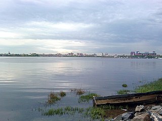
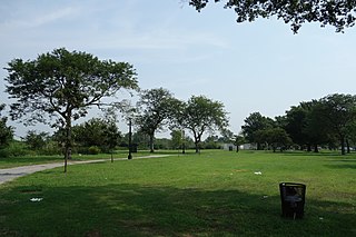
Flushing Bay is a tidal embayment in New York City. It is located on the south side of the East River and stretches to the south near the neighborhood of Flushing, Queens. It is bordered on the west by LaGuardia Airport and the Grand Central Parkway, on the south by Northern Boulevard, and on the east by the neighborhood of College Point. The Flushing River empties into the bay at its southeast corner. A 150-foot-wide navigational channel (46 m) dredged at a depth of 14 feet (4.3 m) runs along much of the bay's length.
Bergen Basin is a tributary inlet to Jamaica Bay in Queens, New York at the northern extremity of Grassy Bay and runs along the western boundary of JFK International Airport. The airport was built on the marshes of Jamaica Bay surrounding Bergen Basin in 1942. Bergen Basin was previously known as Bergen's Landing Aqueduct or Bergen Creek.

The Flushing River, also known as Flushing Creek, is a waterway that flows northward through the borough of Queens in New York City, mostly within Flushing Meadows–Corona Park, emptying into the Flushing Bay and the East River. The river runs through a valley that may have been a larger riverbed before the last Ice Age, and it divides Queens into western and eastern halves. Until the 20th century, the Flushing Creek was fed by three tributaries: Mill Creek and Kissena Creek on the eastern bank, and Horse Brook on the western bank.

Paerdegat Basin is a channel that connects to Jamaica Bay between the neighborhoods of Bergen Beach and Canarsie in southeast Brooklyn, New York, United States. It connects to Jamaica Bay to the south, and the north end of the basin is adjacent to the intersection of Ralph Avenue and Flatlands Avenue. "Paerdegat" derives from the old Dutch paardengat, meaning "horse gate".
Spring Creek, previously called Spring Creek Basin, is a neighborhood within the East New York section of Brooklyn in New York City. It roughly comprises the southern portions of East New York between Flatlands Avenue to the north, and Jamaica Bay and the Gateway National Recreation Area to the south, with the Brooklyn neighborhood of Canarsie to the west and the Queens neighborhood of Howard Beach to the east. It is named after Spring Creek, one of several creeks that formerly ran through the area and drained into Jamaica Bay.
Back River is a tidal estuary in Baltimore County, Maryland, located about 2 miles (3 km) east of the city of Baltimore. The estuary extends from Essex, Maryland, southeast for about 8.8 miles (14.2 km) to the Chesapeake Bay. The watershed area is 39,075 acres (15,813 ha) and includes Essex Skypark Airport and the Back River Wastewater Treatment Plant. The river is shared between Essex, MD, Dundalk, MD, and Edgemere, MD

The Newtown Creek Wastewater Treatment Plant is the largest sewage treatment facility operated by the New York City Department of Environmental Protection. Since 2010, its eight metallic "digester eggs", which are 140 feet tall and dramatically illuminated with blue light at night, have made it a local landmark, particularly to motorists on several nearby roadways in the New York City boroughs of Brooklyn, Queens, and Manhattan. It is located on the Newtown Creek in Brooklyn's Greenpoint neighborhood along Greenpoint Avenue.

Kissena Creek is a buried stream located in the neighborhoods of Flushing, Fresh Meadows, Hillcrest, and Kew Gardens Hills in the New York City borough of Queens. Kissena Creek originates in a now-filled swamp within Kew Gardens Hills and Pomonok in central Queens, flowing east to Hillcrest. The creek then travels mostly north and west, largely flowing beneath Kissena Park Golf Course, Kissena Park, Kissena Corridor Park, and Queens Botanical Garden, before merging with the Flushing River in Flushing Meadows–Corona Park.
AirTrain LaGuardia was a proposed 1.5-mile-long (2.4 km) people mover system and elevated railway in New York City, United States, that would provide service to LaGuardia Airport in Queens. It would have connected with the New York City Subway and Long Island Rail Road (LIRR) in Willets Point, similar to how the existing AirTrain JFK system connects John F. Kennedy International Airport’s six terminals to the LIRR in southern Queens at Jamaica station and to the subway at both Sutphin Boulevard–Archer Avenue–JFK Airport station and Howard Beach-JFK Airport station; and how the existing AirTrain Newark station connects Newark Liberty International Airport’s three terminals to NJ Transit Rail Operations and Amtrak at a dedicated station.
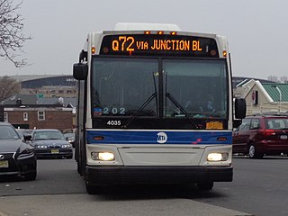
The Q72 bus route constitutes a public transit route along Junction Boulevard and 94th Street in Queens, New York City. It operates between the Rego Park and East Elmhurst neighborhoods of Queens, and extends into LaGuardia Airport at the north end of the borough. It is city-operated under the MTA Bus Company brand of MTA Regional Bus Operations.

Spring Creek Park is a public park along the Jamaica Bay shoreline between the neighborhoods of Howard Beach, Queens, and Spring Creek, Brooklyn, in New York City. Created on landfilled former marshland, the park is mostly an undeveloped nature preserve, with only small portions accessible to the public for recreation.
Edgemere Landfill is a former municipal landfill located in Edgemere on the Rockaway peninsula in Queens, New York City. It is located on a man-made peninsula on the Jamaica Bay shoreline, at the eastern end of the Rockaway peninsula. A portion of the site is currently open to the public as Rockaway Community Park. The entire site is owned by the New York City Department of Parks and Recreation.
