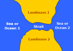
Tidal strait

Last updated
A tidal strait, between two landmasses Seestraat.png
A tidal strait, between two landmasses

A tidal strait is technically not a river but a strait connecting two oceans or seas. Tidal straits are narrow seaways through which tidal currents flow. Tidal currents are usually unidirectional but sometimes are bidirectional. They are frequently of tectonic origin. In them, currents develop because of elevation differences between the water basins at both ends. [1]

Contents

Tides sometimes allow sediments to collect in tidal straits. [2] [3]

Arthur Kill tidal strait, Prall's Island visible Arthur Kill Pralls Island.jpg
Arthur Kill tidal strait, Prall's Island visible

See also

Related Research Articles

Sedimentary rock Rock formed by the deposition and subsequent cementation of material

Sedimentary rocks are types of rock that are formed by the accumulation or deposition of mineral or organic particles at Earth's surface, followed by cementation. Sedimentation is the collective name for processes that cause these particles to settle in place. The particles that form a sedimentary rock are called sediment, and may be composed of geological detritus (minerals) or biological detritus. The geological detritus originated from weathering and erosion of existing rocks, or from the solidification of molten lava blobs erupted by volcanoes. The geological detritus is transported to the place of deposition by water, wind, ice or mass movement, which are called agents of denudation. Biological detritus was formed by bodies and parts of dead aquatic organisms, as well as their fecal mass, suspended in water and slowly piling up on the floor of water bodies. Sedimentation may also occur as dissolved minerals precipitate from water solution.

Strait Naturally formed, narrow, typically navigable waterway that connects two larger bodies of water

A strait is a naturally formed, narrowing, typically navigable waterway that connects two larger bodies of water. The surface water generally flows at the same elevation on both sides and through the strait in either direction. Most commonly it is a channel of water that lies between two land masses. Some straits are not navigable, for example because they are too shallow, or because of an unnavigable reef or archipelago. Straits are also known to be loci for sediment accumulation. Usually, sand-size deposits occur on both the two opposite strait exits, forming subaqueous fans or deltas.

River delta Silt deposition landform at the mouth of a river

A river delta is a landform created by deposition of sediment that is carried by a river as the flow leaves its mouth and enters slower-moving or stagnant water. This occurs where a river enters an ocean, sea, estuary, lake, reservoir, or another river that cannot carry away the supplied sediment. The size and shape of a delta is controlled by the balance between watershed processes that supply sediment, and receiving basin processes that redistribute, sequester, and export that sediment. The size, geometry, and location of the receiving basin also plays an important role in delta evolution. River deltas are important in human civilization, as they are major agricultural production centers and population centers. They can provide coastline defense and can impact drinking water supply. They are also ecologically important, with different species' assemblages depending on their landscape position.

Alluvial fan Fan- or cone-shaped deposit of sediment crossed and built up by streams

An alluvial fan is an accumulation of sediments shaped like a section of a shallow cone, with its apex at a point source of sediments, such as a narrow canyon emerging from an escarpment. They are characteristic of mountainous terrain in arid to semiarid climates, but are also found in more humid environments subject to intense rainfall and in areas of modern glaciation. They range in area from less than 1 square kilometre (0.39 sq mi) to almost 20,000 square kilometres (7,700 sq mi).

Niger Delta Basin (geology)

The Niger Delta Basin, also referred to as the Niger Delta province, is an extensional rift basin located in the Niger Delta and the Gulf of Guinea on the passive continental margin near the western coast of Nigeria with suspected or proven access to Cameroon, Equatorial Guinea and São Tomé and Príncipe. This basin is very complex, and it carries high economic value as it contains a very productive petroleum system. The Niger delta basin is one of the largest subaerial basins in Africa. It has a subaerial area of about 75,000 km2, a total area of 300,000 km2, and a sediment fill of 500,000 km3. The sediment fill has a depth between 9–12 km. It is composed of several different geologic formations that indicate how this basin could have formed, as well as the regional and large scale tectonics of the area. The Niger Delta Basin is an extensional basin surrounded by many other basins in the area that all formed from similar processes. The Niger Delta Basin lies in the south westernmost part of a larger tectonic structure, the Benue Trough. The other side of the basin is bounded by the Cameroon Volcanic Line and the transform passive continental margin.

Tidal bore A water wave traveling upstream a river or narrow bay because of an incoming tide

A tidal bore, often simply given as bore in context, is a tidal phenomenon in which the leading edge of the incoming tide forms a wave of water that travels up a river or narrow bay reversing the direction of the river or bay's current. It is a strong tide that pushes up the river, against the current.

Beaufort Group Third of the main subdivisions of the Karoo Supergroup in South Africa

The Beaufort Group is the third of the main subdivisions of the Karoo Supergroup in South Africa. It is composed of a lower Adelaide Subgroup and an upper Tarkastad Subgroup. It follows conformably after the Ecca Group and unconformably underlies the Stormberg Group. Based on stratigraphic position, lithostratigraphic and biostratigraphic correlations, palynological analyses, and other means of geological dating, the Beaufort Group rocks are considered to range between Middle Permian (Wordian) to Early Triassic (Anisian) in age.

Lacustrine plain Lakes filled by sediment

A lacustrine plain or lake plain is a plain formed due to the past existence of a lake and its accompanying sediment accumulation. Lacustrine plains can be formed through one of three major mechanisms: glacial drainage, differential uplift, and inland lake creation and drainage. Lake plains can have various uses depending on where and how they form.

Ecca Group Second of the main subdivisions of the Karoo Supergroup of geological strata in southern Africa

The Ecca Group is the second of the main subdivisions of the Karoo Supergroup of geological strata in southern Africa. It mainly follows conformably after the Dwyka Group in some sections, but in some localities overlying unconformably over much older basement rocks. It underlies the Beaufort Group in all known outcrops and exposures. Based on stratigraphic position, lithostratigraphic correlation, palynological analyses, and other means of geological dating, the Ecca Group ranges between Early to earliest Middle Permian in age.

Depositional environment Combination of physical, chemical and biological processes associated with the deposition of a particular type of sediment

In geology, depositional environment or sedimentary environment describes the combination of physical, chemical, and biological processes associated with the deposition of a particular type of sediment and, therefore, the rock types that will be formed after lithification, if the sediment is preserved in the rock record. In most cases, the environments associated with particular rock types or associations of rock types can be matched to existing analogues. However, the further back in geological time sediments were deposited, the more likely that direct modern analogues are not available.

Dakota Formation Rock units in Midwestern North America.

The Dakota is a sedimentary geologic unit name of formation and group rank in Midwestern North America. The Dakota units are generally composed of sandstones, mudstones, clays, and shales deposited in the Mid-Cretaceous opening of the Western Interior Seaway. The usage of the name Dakota for this particular Albian-Cenomanian strata is exceptionally widespread; from British Columbia and Alberta to Montana and Wisconsin to Colorado and Kansas to Utah and Arizona. It is famous for producing massive colorful rock formations in the Rocky Mountains and the Great Plains of the United States, and for preserving both dinosaur footprints and early deciduous tree leaves.

A mouth bar is an element of a deltaic system, which refers to typically mid-channel deposition of the sediment transported by the river channel at the river mouth.

A contourite is a sedimentary deposit commonly formed on continental rise to lower slope settings, although they may occur anywhere that is below storm wave base. Countourites are produced by thermohaline-induced deepwater bottom currents and may be influenced by wind or tidal forces. The geomorphology of contourite deposits is mainly influenced by the deepwater bottom-current velocity, sediment supply, and seafloor topography.

The Porcupine Hills Formation is a stratigraphic unit of middle to late Paleocene age in the Western Canada Sedimentary Basin. It takes its name from the Porcupine Hills of southwestern Alberta, and was first described in outcrop by George Mercer Dawson in 1883.

Dwyka Group Geological group in the Karoo Supergroup from South Africa

The Dwyka Group is one of four geological groups that compose the Karoo Supergroup. It is the lowermost geological group and heralds the commencement of sedimentation of the Karoo Supergroup. Based on stratigraphic position, lithostratigraphic correlation and palynological analyses, these lowermost Karoo strata range between the Late Carboniferous (Pennsylvanian) to Early Permian in age.

Northern North Sea basin

The North Sea is part of the Atlantic Ocean in northern Europe. It is located between Norway and Denmark in the east, Scotland and England in the west, Germany, the Netherlands, Belgium and France in the south.

Angola Basin

The Angola Basin is located along the West African South Atlantic Margin which extends from Cameroon to Angola. It is characterized as a passive margin that began spreading in the south and then continued upwards throughout the basin. This basin formed during the initial breakup of the supercontinent Pangaea during the early Cretaceous, creating the Atlantic Ocean and causing the formation of the Angola, Cape, and Argentine basins. It is often separated into two units: the Lower Congo Basin, which lies in the northern region and the Kwanza Basin which is in the southern part of the Angola margin. The Angola Basin is famous for its "Aptian Salt Basins," a thick layer of evaporites that has influenced topography of the basin since its deposition and acts as an important petroleum reservoir.

Kutai Basin

The Kutai sedimentary basin extends from the central highlands of Borneo, across the eastern coast of the island and into the Makassar Strait. With an area of 60,000 km2, and depths up to 15 km, the Kutai is the largest and deepest Tertiary age basin in Indonesia. Plate tectonic evolution in the Indonesian region of SE Asia has produced a diverse array of basins in the Cenozoic. The Kutai is an extensional basin in a general foreland setting. Its geologic evolution begins in the mid Eocene and involves phases of extension and rifting, thermal sag, and isostatic subsidence. Rapid, high volume, sedimentation related to uplift and inversion began in the Early Miocene. The different stages of Kutai basin evolution can be roughly correlated to regional and local tectonic events. It is also likely that regional climate, namely the onset of the equatorial ever wet monsoon in early Miocene, has affected the geologic evolution of Borneo and the Kutai basin through the present day. Basin fill is ongoing in the lower Kutai basin, as the modern Mahakam River delta progrades east across the continental shelf of Borneo.

Otway Basin

The Otway Basin is a northwest trending sedimentary basin located along the southern coast of Australia. The basin covers an area of 150,000 square kilometers and spans from southeastern South Australia to southwestern Victoria, with 80% lying offshore in water depths ranging from 50-3,000 meters. Otway represents a passive margin rift basin and is one of a series of basins located along the Australian Southern Rift System. The basin dates from the late Jurassic to late Cretaceous periods and formed by multi-stage rifting during the breakup of Gondwana and the separation of the Antarctic and Australian plates. The basin contains a significant amount of natural gas and is a current source of commercial extraction.

Junggar Basin

The Junggar Basin is one of the largest sedimentary basins in Northwest China. It is located in Xinjiang, and enclosed by the Tarbagatai Mountains of Kazakhstan in the northwest, the Altai Mountains of Mongolia in the northeast, and the Heavenly Mountains in the south. The geology of Junggar Basin mainly consists of sedimentary rocks underlain by igneous and metamorphic basement rocks. The basement of the basin was largely formed during the development of the Pangea supercontinent during complex tectonic events from Precambrian to late Paleozoic time. The basin developed as a series of foreland basins – in other words, basins developing immediately in front of growing mountain ranges – from Permian time to the Quaternary period. The basin's preserved sedimentary records show that the climate during the Mesozoic era was marked by a transition from humid to arid conditions as monsoonal climatic effects waned. The Junggar basin is rich in geological resources due to effects of volcanism and sedimentary deposition.

References

  1. Longhitano, Sergio G.; Mellere, Donatella; Steel, Ronald J.; Ainsworth, R. Bruce (April 9, 2012). "Tidal depositional systems in the rock record: A review and new insights" (PDF). basin.earth.ncu.edu.tw. Retrieved 27 May 2019.CS1 maint: multiple names: authors list (link)
  2. Longhitano, Sergio; Steel, Ronald J. (June 2015). "Deltas sourcing tidal straits: observations from some field case studies" . Retrieved 27 May 2019.CS1 maint: multiple names: authors list (link)
  3. Rossia, V.M.; Longhitano, S.G.; Mellere, D.; Dalrymple, R.W.; Steela, R.J.; Chiarellae, D.; Olariua, C. (November 2017). "Interplay of tidal and fluvial processes in an early Pleistocene, delta-fed, strait margin (Calabria, Southern Italy)". Marine and Petroleum Geology. Retrieved 27 May 2019.CS1 maint: multiple names: authors list (link)