Related Research Articles

The Fresh Kills Landfill was a landfill covering 2,200 acres (890 ha) in the borough of Staten Island in New York City, United States. The name comes from the landfill's location along the banks of the Fresh Kills estuary in western Staten Island.

New Dorp is a neighborhood on the South Shore of Staten Island, New York City, United States. New Dorp is bounded by Mill Road on the southeast, Tysens Lane on the southwest, Amboy and Richmond Roads on the northwest, and Bancroft Avenue on the northeast. It is adjacent to Oakwood to the southwest, Todt Hill to the northwest, Dongan Hills and Grant City, and Midland Beach and Miller Field to the southeast. New Dorp Beach, bordering to the east, is often listed on maps as a separate neighborhood from Mill Road to the shore of Lower New York Bay, but is generally considered to be a part of New Dorp.

Midland Beach is a neighborhood of Staten Island in New York City. It lies along the east-central coast of the island, in the area known locally as the "Mid-Island, Staten Island" or the "East Shore".

Richmond Creek is a major stream in Staten Island, New York City. Its upper drainage basin includes the remote forested hills in the center of the island. It empties into the Fresh Kills.
Prince's Bay is a neighborhood located on the South Shore of New York City's borough of Staten Island. Prince's Bay is bordered to the north by Huguenot, to the south by the Raritan Bay, and to the west by Pleasant Plains. The neighborhood is represented in the New York State Senate by Andrew Lanza, in the New York State Assembly by Michael Reilly, and in the New York City Council by Joe Borelli.

The term North Shore is frequently applied to a series of neighborhoods within the New York City borough of Staten Island.
Mid-Island is frequently applied to a series of neighborhoods within the New York City borough of Staten Island.

Lemon Creek is a stream located on the South Shore of Staten Island in New York City. It is one of the few remaining ground-level creeks in New York City.

South Beach is a neighborhood on the East Shore of Staten Island, New York City, situated directly south of the Verrazzano-Narrows Bridge. South Beach is bounded by New York Bay on the southeast, Seaview Avenue on the southwest, Laconia Avenue on the northwest, Reid and McClean Avenues on the north, and Lily Pond Avenue on the northeast. It is adjacent to Midland Beach to the southwest, Dongan Hills and Old Town/Concord to the northwest, and Fort Wadsworth and Rosebank to the northeast.

Dongan Hills is a neighborhood located within the New York City borough of Staten Island. It is on the island's East Shore. Dongan Hills is bounded by Laconia Avenue to the southeast, Jefferson Avenue on the southwest, Richmond Road on the northwest, and Old Town Road to the north. It is adjacent to New Dorp and Grant City to the southwest, Todt Hill to the northwest, Old Town/Concord to the northeast, and South Beach and Midland Beach to the southeast.
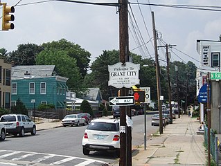
Grant City is a neighborhood located on the East Shore of Staten Island, New York City.
New Dorp Beach is along the shore of the neighborhood of New Dorp, on Staten Island, one of the five boroughs of New York City. It is between Midland Beach and Oakwood Beach.

The Flushing River, also known as Flushing Creek, is a waterway that flows northward through the borough of Queens in New York City, New York, U.S. It runs mostly within Flushing Meadows–Corona Park, emptying into the Flushing Bay and the East River. The river runs through a valley that may have been a larger riverbed before the last Ice Age, and it divides Queens into western and eastern halves. Until the 20th century, the Flushing Creek was fed by three tributaries: Mill Creek and Kissena Creek on the eastern bank, and Horse Brook on the western bank.

Clear Creek is a stream in northeast Atlanta that serves as a tributary to Peachtree Creek and is part of the Chattahoochee River watershed. It has two main branches: one originating east of the high ground along Boulevard and another to the west, originating on the northeast side of downtown Atlanta.

Paerdegat Basin is a channel that connects to Jamaica Bay between the neighborhoods of Bergen Beach and Canarsie in southeast Brooklyn, New York, United States. It connects to Jamaica Bay to the south, and the north end of the basin is adjacent to the intersection of Ralph Avenue and Flatlands Avenue. "Paerdegat" derives from the old Dutch paardengat, meaning "horse gate".

The Bluebelt is a large scale system of stormwater best management practices (BMPs) in New York City. The program originated on Staten Island in the early 1990s, but has also been implemented in Queens and the Bronx. The Bluebelt includes structural and nonstructural stormwater management control measures taken to mitigate changes to both quantity and quality of runoff caused through changes to land use.

The South Beach–Franklin Delano Roosevelt Boardwalk, alternately referred to as the FDR Boardwalk or the South Beach Boardwalk, is a boardwalk facing the Lower New York Bay on the East Shore of Staten Island, one of the five boroughs of New York City. The boardwalk is the main feature of a public park that stretches from Fort Wadsworth and the Verrazzano-Narrows Bridge to Miller Field, both part of the Gateway National Recreation Area. The park also contains numerous recreational facilities, including a skate park.
The William T. Davis Wildlife Refuge (WTDWR) is an 814-acre (3.29 km2) wildlife refuge straddling the New Springville and Travis sections of Staten Island. The park was named in honor of Staten Island native William T. Davis, a renowned naturalist and entomologist who along with the Audubon Society started the refuge with an original acquisition of 52 acres (210,000 m2). Additional acreage was acquired in increments and the park is today 814 acres (3.29 km2). Beginning in 2010, the adjacent 223-acre (0.90 km2) North Park section of Freshkills Park has undergone preparation to serve as an expansion of the wildlife refuge.

Springfield Park is a public park in Springfield Gardens, in southeast Queens, New York City. It consists of 23.54 acres (9.53 ha), including the sizable Springfield Lake at its center. It is located on the west side of Springfield Boulevard between 145th Road and 147th Avenue, less than a mile north of JFK Airport. It is maintained by the New York City Department of Parks and Recreation.
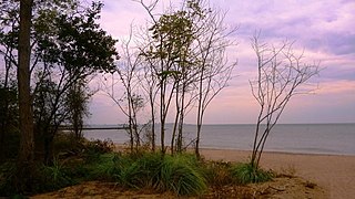
Last Chance Pond Park is a wetland park located on Staten Island's East Shore and part of the main channel of the New Creek stream and the Staten Island Bluebelt. Located on the northeast migration flyway, Last Chance Pond Park hosts a wide range of local flora and fauna that visit and live in the landscape of the park that includes two saltwater marshes, a fresh spring, and a freshwater pond. The park was named after the Last Chance Pond and Wilderness Foundation which helped to preserve the site starting in the mid-1960s.
References
- ↑ Seminar for US EPA Urban Watershed Management Branch Edison, NJ.
- ↑ "Project Description for the New Creek Drainage Plan" (PDF).
- ↑ Kadinsky, Sergey (2016-03-07). Hidden Waters of New York City: A History and Guide to 101 Forgotten Lakes, Ponds, Creeks, and Streams in the Five Boroughs. The Countryman Press. ISBN 978-1-58157-566-8.
- ↑ Kensinger, Nathan (2016-12-01). "On Staten Island, a centuries-old waterway helps shape new wetlands". Curbed NY. Retrieved 2023-01-15.
- ↑ "$75 Million Expansion of Mid-Island Bluebelt Underway". NYC.GOV. October 1, 2020. Retrieved 2023-01-15.
- ↑ "City and Borough President Oddo Tour Progress of $121 Million Mid-Island Bluebelt Expansion". NYC.GOV. July 26, 2021. Retrieved 2023-01-15.
40°34′38.02″N74°5′5.13″W / 40.5772278°N 74.0847583°W
| | This article about a location on Staten Island, New York is a stub. You can help Wikipedia by expanding it. |