River that runs wholly or partly beneath the ground surface
A subterranean river in the Cross Cave system of Slovenia. (Scale shown by people in photograph.)
A subterranean river (also known as an underground river) is a river or watercourse that runs wholly or partly beneath the ground, one where the riverbed does not represent the surface of the Earth.[1] It is distinct from an aquifer, which may flow like a river but is contained within a permeable layer of rock or other unconsolidated materials. A river flowing below ground level in an open gorge is not classed as subterranean.[2]
Some natural rivers may be entirely subterranean, collecting in and flowing through cave systems. In karst topography, rivers that originate above ground can disappear into sinkholes, continuing underground until they reappear on the surface downstream, possibly having merged with other subterranean rivers. The longest subterranean river in the world is the Sistema Sac Actun cave system in Mexico.[3]
Subterranean rivers can also be the result of covering over a river or diverting its flow into culverts, usually as part of urban development.[4] Reversing this process is known as "daylighting" a watercourse and is a major form of visible river restoration. Successful examples include the Cheonggyecheon in the centre of Seoul.[5][6]
Some fish (colloquially known as cavefish) and other troglobite organisms are adapted to life in subterranean rivers and lakes.[7]
Examples of subterranean rivers also occur in mythology and literature.
Natural examples
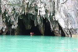
The cave of source of the Buna can be entered by boat and dived through a cave system serving as an effluence of the Zalomka.The Puerto Princesa cave can be entered by boat.Devil's Throat Cave subterranean river from above
There are many natural examples of subterranean rivers. Among them:
In many cities there are natural streams which have been partially or entirely built over. Such man-made examples of subterranean urban streams are too numerous to list, but notable examples include:
This page is based on this Wikipedia article Text is available under the CC BY-SA 4.0 license; additional terms may apply. Images, videos and audio are available under their respective licenses.