Taddle Creek

Last updated
Taddle Creek
Taddle Creek - McCaul's Pond.jpg
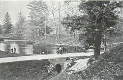
Taddle Creek, dammed to create McCaul's Pond, on the University of Toronto campus in 1870
Location
Country Canada
State Ontario
City Toronto
Physical characteristics
Source 
  locationBathurst Street and St. Clair Avenue West, Toronto, Ontario, Canada
Mouth  
  location
Lake Ontario, just east of Parliament Street, Toronto, Ontario, Canada
Length6 km (3.7 mi)

Taddle Creek is a buried stream in Toronto, Ontario, Canada that flowed a southeasterly course about six kilometres long, from St. Clair Avenue west of Bathurst Street through the present site of Wychwood Park, through the University of Toronto, into the Toronto Harbour near the Distillery District. [1] During the 19th century, it was buried and converted into an underground sewer, but traces of the creek can still be found today. The scenic footpath known as Philosopher's Walk follows the ravine created by the creek from the Royal Ontario Museum to Trinity College. Taddle Creek is also the name of a Toronto literary magazine and of a local Montessori school. [2]

Contents

History

Watercolour painting of Taddle Creek in 1861. University College, Toronto is in the background. Taddle creek 1861 CBC.png
Watercolour painting of Taddle Creek in 1861. University College, Toronto is in the background.

In the 1790s, the original town site of the Town of York was established along its south bank. Its waters would be used by its first industries. The disappearance of the creek came in phases in the 19th century:

There is no exact origin for the creek's name but there are three possible theories: [3]

Taddle Creek had other names during the 19th Century:

See also

Related Research Articles

<span class="mw-page-title-main">York, Upper Canada</span> Unincorporated municipality in Home District, Upper Canada

York was a town and the second capital of the colony of Upper Canada. It is the predecessor to the old city of Toronto (1834–1998). It was established in 1793 by Lieutenant-Governor John Graves Simcoe as a "temporary" location for the capital of Upper Canada, while he made plans to build a capital near today's London, Ontario. Simcoe renamed the location York after Prince Frederick, Duke of York and Albany, George III's second son. Simcoe gave up his plan to build a capital at London, and York became the permanent capital of Upper Canada on February 1, 1796. That year Simcoe returned to Britain and was temporarily replaced by Peter Russell.

<span class="mw-page-title-main">Rouge River (Ontario)</span> River in Ontario, Canada

The Rouge River is a river in Markham, Pickering, Richmond Hill and Toronto in the Greater Toronto Area of Ontario, Canada. The river flows from the Oak Ridges Moraine to Lake Ontario at the eastern border of Toronto, and is the location of Rouge Park, the only national park in Canada within a municipality. At its southern end, the Rouge River is the boundary between Toronto and southwestern Pickering in the Regional Municipality of Durham.

<span class="mw-page-title-main">Grand River (Ontario)</span> River in Ontario, Canada

The Grand River, formerly known as the River Ouse, is a large river in Ontario, Canada. It lies along the western fringe of the Greater Golden Horseshoe region of Ontario which overlaps the eastern portion of southwestern Ontario, sometimes referred to as Midwestern Ontario, along the length of this river. From its source near Wareham, Ontario, it flows south through Grand Valley, Fergus, Elora, Waterloo, Kitchener, Cambridge, Paris, Brantford, Ohsweken, Six Nations of the Grand River, Caledonia, and Cayuga before emptying into the north shore of Lake Erie south of Dunnville at Port Maitland. One of the scenic and spectacular features of the river is the falls and Gorge at Elora.

<span class="mw-page-title-main">Bowmanville</span> Place in Ontario, Canada

Bowmanville is a town of approximately 40,000 people located in the Municipality of Clarington, Durham Region, Ontario, Canada. It is approximately 75 km (47 mi) east of Toronto, and 15 km (9.3 mi) east of Oshawa along Highway 2. Bowmanville was first incorporated as a town in 1858, but later incorporated with the neighbouring townships of Clarke and Darlington in 1974 forming the Town of Newcastle, which was renamed in 1994 to the Municipality of Clarington. Bowmanville is part of the Greater Toronto Area.

<span class="mw-page-title-main">Mimico Creek</span> River in Ontario, Canada

Mimico Creek is a stream that flows through Brampton, Mississauga and Toronto in the Greater Toronto Area of Ontario, Canada. It is 33 kilometres (21 mi) long, is in the Great Lakes Basin, and is a tributary of Lake Ontario.

<span class="mw-page-title-main">Toronto Harbour</span> Bay on the north shore of Lake Ontario, in Toronto, Ontario, Canada

Toronto Harbour or Toronto Bay is a natural bay on the north shore of Lake Ontario, in Toronto, Ontario, Canada. Today, the harbour is used primarily for recreational boating, including personal vessels and pleasure boats providing scenic or party cruises. Ferries travel from docks on the mainland to the Islands, and cargo ships deliver aggregates and raw sugar to industries located in the harbour. Historically, the harbour has been used for military vessels, passenger traffic and cargo traffic. Waterfront uses include residential, recreational, cultural, commercial and industrial sites.

<span class="mw-page-title-main">Garrison Creek (Ontario)</span> River in Ontario, Canada

Garrison Creek was a short stream about 7.7 kilometres (4.8 mi) long that flowed southeast into the west side of Toronto Harbour in Ontario, Canada. It has been largely covered over and filled in, but geographical traces of the creek can still be found, including the natural amphitheatre known as Christie Pits and the off-leash dog "bowl" of Trinity Bellwoods Park. The name "Garrison Creek" was used because Fort York was built near the creek mouth. Volunteers lead popular tours of the course of the old watershed.

<span class="mw-page-title-main">Trinity Bellwoods Park</span> Public park in Toronto, Ontario, Canada

Trinity Bellwoods Park is a public park located in Toronto, Ontario, Canada, bordered by Queen Street West on the south and Dundas Street on the north. The western boundary of the park is Crawford Street, several hundred feet before Crawford intersects with Dundas St. West, the park juts toward Shaw Street, westside of the Crawford Street Bridge. Most of the park's area lies in the original Garrison Creek ravine and this creek, now a buried city storm sewer, still flows beneath the park from the northwest to the southeast corners.

<span class="mw-page-title-main">Russell Creek (Ontario)</span> River in Ontario, Canada

Russell Creek was a short creek, 3.4 kilometres (2.1 mi) long, that flowed through what is now downtown Toronto, Ontario, Canada, west of the original town of York. The creek was named for Peter Russell and flowed generally southeast, like all the other waterways in Toronto, reflecting the recent glaciation, into Toronto Harbour near the present CN Tower. The creek was buried in 1876, but traces of it can still be found, for instance on the grounds of the historic Grange mansion.

<span class="mw-page-title-main">Maple, Ontario</span> Neighbourhood in York Region, Ontario, Canada

Maple is a neighbourhood in Vaughan, York Region, Ontario, Canada. It is located northwest of Toronto. Maple was founded as the village of Maple, located at the intersection of Major Mackenzie Drive and Keele Street.

<span class="mw-page-title-main">Front Street (Toronto)</span> Thoroughfare in Toronto, Ontario

Front Street is an east–west road in downtown Toronto, Ontario, Canada. First laid out in 1796, the street is one of the original streets of the Town of York. The street was laid out along the shoreline of Lake Ontario as it existed during that time. It remains an important street, with many important uses located along it, including the St. Lawrence Market, Meridian Hall, Union Station and the Metro Toronto Convention Centre. The eastern section of Front Street, in the West Don Lands, east of Cherry Street, is being rebuilt as a broad tree-lined boulevard, intended to be the pedestrian-friendly commercial spine of the new neighbourhood.

<span class="mw-page-title-main">Black Creek (Toronto)</span> River in Ontario, Canada

Black Creek is a river in the Golden Horseshoe region of Ontario, Canada. It flows from the city of Vaughan in the Regional Municipality of York to the Humber River in Toronto. Black Creek is smaller than most of the waterways in the Greater Toronto Area.

<span class="mw-page-title-main">Toronto ravine system</span> Geographical formations in Toronto, Canada

The Toronto ravine system is a distinctive feature of the city's geography, consisting of a network of deep ravines, which forms a large urban forest that runs through most of Toronto. The ravine system is the largest in any city in the world, with the Ravine and Natural Feature Protection Bylaw protecting approximately 110 square kilometres (42 sq mi) of public and privately-owned land. The ravine system has been presented as a central characteristic of the city, with the size of the ravine system leading Toronto to be described as "a city within a park".

<span class="mw-page-title-main">Wychwood Park</span> Neighbourhood in Toronto, Ontario, Canada

Wychwood Park is a neighbourhood enclave and private community in Toronto, Ontario, Canada. It is located west of Bathurst Street on the north side of Davenport Road, within the larger area of Bracondale Hill. It is considered part of the overall Wychwood official neighbourhood as designated by the City of Toronto.

<span class="mw-page-title-main">West Don Lands</span> Neighbourhood in Toronto, Ontario, Canada

The West Don Lands are the site of a neighbourhood under construction in Toronto, Ontario, Canada. The area is bordered by the Don River, King Street, Parliament Street and the rail line adjacent to the Gardiner Expressway. It is 80 hectares in size. A former industrial area, the area is being rebuilt as a mixed-use neighbourhood.

<span class="mw-page-title-main">Highland Creek (Toronto)</span> River in Ontario, Canada

Highland Creek is a river in the Scarborough district of Toronto, Ontario, emptying into Lake Ontario at the eastern end of the Scarborough Bluffs. It is home to several species of fish including trout, carp, bass and salmon. It is a meandering river which, like most rivers in Toronto, travels through a glacial ravine formed after the last Ice Age. The Highland Creek watershed, including tributaries, is almost entirely contained within Scarborough.

<span class="mw-page-title-main">Trinity Square (Toronto)</span>

Trinity Square is a public square in downtown Toronto, Ontario, Canada. It is bounded on the east by the Toronto Eaton Centre, on the south and west by the Bell Trinity Square office complex, and on the north by the Marriott Downtown Eaton Centre hotel.

<span class="mw-page-title-main">Tomlin's Creek</span> River in Ontario, Canada

Tomlin's Creek is short creek in Toronto, which drained into Small's Pond. Its headwaters seem to have been in the ravine that contains Glen Davis Crescent, because residents report small springs breaking out.

<span class="mw-page-title-main">Toronto waterway system</span>

The Toronto waterway system comprises a series of natural and man-made watercourses in the Canadian city of Toronto. The city is dominated by a large river system spanning most of the city including the Don River, Etobicoke Creek, Highland Creek, Humber River, Mimico Creek and Rouge River.

<span class="mw-page-title-main">McCaul's Pond</span>

McCaul's Pond was located at the site of Hart House, on the University of Toronto campus. It was created by damming Taddle Creek in the early 1860s. Increased settlement and economic activity had already begun changing the creek from being the clear, free running watercourse that the early settlers had found. It had been so clean that it was a breeding ground for salmon, but over time had become a polluted watercourse. Damming the creek accelerated the dangers and the pond was drained prior to burying the University's portion of the creek in 1884.

References

  1. Wayne Reeves; Christina Palassio (2008-10-01). HTO: Toronto's water from Lake Iroquois to lost rivers to low-flow toilets. Coach House Press. ISBN   978-1-55245-208-0 . Retrieved 2011-12-29.
  2. "In the Community: Taddle Creek Montessori is Standing Up for Kids – The Buzz". www.cafdn.org. Archived from the original on 2020-08-09. Retrieved 2018-11-09.
  3. "Legend 52. Taddle Creek". Town of York Historical Society. Archived from the original on December 30, 2014.