
Line 1 Yonge–University is a rapid transit line of the Toronto subway. It serves Toronto and the neighbouring city of Vaughan in Ontario, Canada. It is operated by the Toronto Transit Commission, has 38 stations and is 38.4 km (23.9 mi) in length, making it the longest line on the subway system. It opened as the "Yonge subway" in 1954 as Canada's first underground passenger rail line and was extended multiple times between 1963 and 2017. As of 2010, Line 1 was the busiest rapid transit line in Canada, and one of the busiest lines in North America. In 2022, it averaged over 670,000 riders per weekday.

St. Clair Avenue is a major east-west street in Toronto, Ontario, Canada. It was laid out in the late 18th century by the British as a concession road, 2 kilometres (1.2 mi) north of Bloor Street and 4 kilometres (2.5 mi) north of Queen Street.

Toronto—St. Paul's is a federal electoral district in Toronto, Ontario, Canada, that has been represented in the House of Commons of Canada since 1935. Before the 2015 election, the riding was known as St. Paul's.
Allen Road, formally known as William R. Allen Road, is a short municipal expressway and arterial road in Toronto, Ontario, Canada. It starts as a controlled-access expressway at Eglinton Avenue West, heading north to just south of Transit Road, then continues as an arterial road north to Kennard Avenue, where it continues as Dufferin Street. Allen Road is named after Metro Toronto chairman William R. Allen and is maintained by the City of Toronto. Landmarks along the road include the Lawrence Heights housing project, Yorkdale Shopping Centre and Downsview Park, and Downsview Airport. A section of the Line 1 Yonge–University subway is located within the median of the expressway from Eglinton Avenue to north of Wilson Avenue.

St. Clair West is a subway station on Line 1 Yonge–University in Toronto, Ontario, Canada. It spans the block north of St. Clair Avenue West to Heath Street, between Bathurst Street and Tweedsmuir Avenue. The station serves the local communities of Forest Hill South, Humewood, Bracondale Hill and Casa Loma.

Castle Frank is a subway station on Line 2 Bloor–Danforth of the Toronto subway. It is located at the northwest corner of Bloor Street East and Castle Frank Road. Wi-Fi service is available at this station.

Toronto Civic Railways (TCR) was a streetcar operator created and owned by the City of Toronto, Ontario, Canada, to serve newly annexed areas of the city that the private operator Toronto Railway Company refused to serve. When the Toronto Railway Company's franchise expired in 1921, its services were combined with those of the Toronto Civic Railways, and are now assumed by the new Toronto Transportation Commission (TTC). The first route of the TCR started operation on December 18, 1912.

The cancelled expressways in Toronto were a planned series of expressways in Toronto, Ontario, Canada that were only partially built or cancelled due to public opposition. The system of expressways was intended to spur or handle growth in the suburbs of Toronto, but were opposed by citizens within the city of Toronto proper, citing the demolition of homes and park lands, air pollution, noise and the high cost of construction. The Spadina Expressway, planned since the 1940s, was cancelled in 1971 after being only partially constructed. After the Spadina cancellation, other expressway plans, intended to create a 'ring' around the central core, were abandoned.

Bloor Street is an east–west arterial road in Toronto, Ontario, Canada. Bloor Street runs from the Prince Edward Viaduct, which spans the Don River Valley, westward into Mississauga where it ends at Central Parkway. East of the viaduct, Danforth Avenue continues along the same right-of-way. The street, approximately 25 kilometres (16 mi) long, contains a significant cross-sample of Toronto's ethnic communities. It is also home to Toronto's famous shopping street, the Mink Mile.

Bathurst Street is a main north–south arterial road in Toronto, Ontario, Canada. It begins at an intersection of the Queens Quay roadway, just north of the Lake Ontario shoreline. It continues north through Toronto to the Toronto boundary at Steeles Avenue. It is a four-lane thoroughfare throughout Toronto. The roadway continues north into York Region where it is known as York Regional Road 38.
Black Creek Drive is a limited-access arterial road in Toronto, Ontario, Canada. A four-lane route that runs north–south, it connects Weston Road and Humber Boulevard with Highway 401 via Highway 400, the latter of which it forms a southerly extension. Black Creek Drive officially transitions into Highway 400 at the Maple Leaf Drive overpass, southeast of the Jane Street interchange. The roadway is named after the Black Creek ravine, which it parallels for most of its route. It features a maximum speed limit of 70 km/h (43 mph).

Cedarvale Park is a park located in Toronto, Ontario, Canada. It is bordered by very steep hills, and is located in the Cedarvale neighbourhood of Toronto. The Line 1 Yonge–University subway tunnels underneath it, between St. Clair West and Eglinton West stations; near the Markdale TTC Emergency Exit. The north end of the park contains the Phil White (Cedarvale) Arena and The Leo Baeck Day School, formerly Arlington Middle School. It is commonly used by dog walkers and students returning from the nearby school. The park contains a cricket pitch and soccer goals as permanent fixtures. In the winter, the larger hills within the park are used for tobogganing.

Humewood–Cedarvale is an area of Toronto, Ontario, Canada, consisting of Humewood in the south, divided by Vaughan Road and Cedarvale Ravine. The neighbourhood is bordered by Bathurst Street on the east, Eglinton Avenue to the north, Arlington Avenue to the west, and St. Clair Avenue to the south. Humewood has also been known as "the Woods" because of its many streets that have names ending with "-wood", including Wychwood, Humewood, Cherrywood, Valewood, Maplewood, Wellwood, Kenwood, and Pinewood. The neighbourhood's main commercial areas are along St. Clair Ave. W., referred to as Hillcrest Village and along Eglinton Ave. W..

South Hill is a neighbourhood in Toronto, Ontario, Canada. It is located north of downtown and covers the area west of Avenue Road, south of St. Clair Avenue, east of Spadina Road, and north of the Canadian Pacific railway tracks. The area is dominated by the steep hill of the Davenport Road escarpment. The Nordheimer Ravine also cuts through the area, which is surrounded by Sir Winston Churchill Park. This park covers the northwestern portion of South Hill.
Ossington Avenue is a main or arterial street in Toronto, Ontario, Canada, west of downtown. While the northern 3 kilometres (1.9 mi) of Ossington Avenue is residential, its southern terminus is popularly known as the Ossington Strip, an area popular for its dining, nightlife and shopping establishments.

Mount Pleasant Road is a major arterial thoroughfare in Toronto, Ontario, Canada. The street extends from Jarvis Street south of Bloor Street north to Glen Echo Drive. The road is unique as one of the few arterial roads in Toronto to be created after the development of the suburbs which it passes through. These include the wealthy Rosedale, Moore Park and Lawrence Park neighbourhoods. The road also passes through the centre of Mount Pleasant Cemetery, after which it takes its name.

Following the Upper Canada Rebellion of 1837 Lieutenant Governor of Upper Canada Sir George Arthur directed the construction of a Sherbourne Blockhouse, and a ring of six other blockhouses -- to guard the approaches to Toronto in case there was another rebellion. The Sherbourne Blockhouse was located at the northern end of Sherbourne Street, at the current intersection with Bloor, just south of the Rosedale Ravine.


 The Nordheimer Ravine, named after Samuel Nordheimer, a piano importer who lived nearby
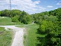
 The Russell Hill Emergency exit located in Winston Churchill Park
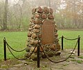 Historical marker, located south of Bloor Street adjacent to Castle Frank station, was placed on the approximate site of the historic Castle Frank residence in 1954
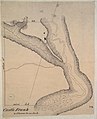 Map of Castle Frank
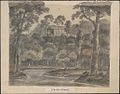 Sketch of Castle Frank by Elizabeth Simcoe, 1796


