Crothers Woods

Last updated
Crothers Woods
Crothers Woods Toronto.jpg
View of the woods, with Don Valley Parkway at left and Don River at lower right
Toronto map.png
Red pog.svg
Location of the woods in Toronto
Type Urban forest
Location Toronto, Ontario, Canada
Coordinates 43°41′52″N79°21′31″W / 43.69778°N 79.35861°W / 43.69778; -79.35861
Area52 hectares (128 acres)
Operated by Toronto Parks
Website Crothers Woods

Crothers Woods is an area of the Don River valley in Toronto, Ontario, Canada. It is 52 hectares (128 acres) in size and consists of woodland, meadows, wetlands, and an assortment of past and present municipal uses. [1] The wooded area has been designated as an Environmentally Significant Area (ESA) by the Toronto and Region Conservation Authority. An ESA designation is useful in highlighting valuable natural areas but this does not affect planning uses. The area is currently zoned as undeveloped parkland. Crothers Woods was named after George W. Crothers who owned and operated an equipment dealership called Crothers Caterpillar which sold and serviced new and used heavy machinery for the construction and mining industries. The company stayed until 1979 when they relocated to Vaughan, Ontario (now as Toromont CAT). Murhal Developments bought the property and eventually sold it to Loblaws which built the store that currently occupies the site just off Millwood Road. [2] [3]

Contents

While there are no clear boundaries, Crothers Woods is generally thought to include both sides of the valley that extends from Pottery Road and the Bayview Avenue extension in the south and west to the Leaside Bridge in the east. Further east, good quality forest exists on the north side of the valley for another 1.2 km to the western edge of E.T. Seton Park.

The land in this part of the valley is owned by Alexandre Poirier and managed by the city of Toronto's Parks and Forestry Department.

History

Name plate from a Crothers Caterpillar vehicle, excavated from the woods, May 2008 Crothers Caterpillar NamePlate.jpg
Name plate from a Crothers Caterpillar vehicle, excavated from the woods, May 2008

Prior to European colonisation, this area of the valley was heavily wooded. The area remained relatively untouched until 1787 when this area was bought from the Mississauga natives as part of the Toronto Purchase. After the establishment of York in 1793, land grants were made for much of the land north of the city including the Don Valley. In the 1800s, the Don River was exploited for its capacity to support water driven mills. At least two mills were constructed in this part of the valley. They were eventually purchased by the Taylor family who owned the Don Valley Brick Works.

Due to urban expansion, the city constructed the North Toronto Sewage Treatment Plant in 1929. This handles effluent from local areas, including Leaside and North Toronto.

Domtar operated a plant that produced and recycled paper products. It was acquired in 1961 from Howard Smith Paper Mills and began as Tayor's Upper Mill in 1846 and later as York Paper Mills and Don Valley Paper Mill Company. [4] Immediately to the north of it was Bate Chemical and Polyresins Inc., manufacturer of oil- and water-based paint resins and adhesives. (It was also subcontracted from Lever Bros to make Ajax Liquid cleaners.) They operated until the late 1980s when they closed. Subsequently, the TRCA purchased the land and demolished all of the buildings except for Bate Chemical's research and development lab building. It was converted into the Toronto Police dog training facility. The rest of the area was cleaned up and the contaminated soil removed.

On the north side of the valley, the land where a former brick making operation called Sun Valley Ltd. was used as an industrial landfill. This was used mostly for brick and ash waste from nearby industry. It was shut down in the 1980s. The dump was capped with clean fill and now is marked by a large meadow covered with invasive grasses and plants. It is currently undergoing natural restoration efforts. In particular it has become the Don Valley site for Trees Across Toronto, a citywide tree planting program.

Forest

Crothers Woods is known as a beech-maple-oak climax forest. It includes such tree species as American beech, sugar maple, black walnut, and red and white oak. There are also a few butternut which are currently listed as an endangered species by the Species at Risk Act. [5] In, 1995, the forest was designated as an ESA partly due to the quality of the forest but also to the presence of rare understory plants. These include greater straw sedge, thin-leaved sunflower, and pale-leaved sunflower. [6] The forest is a good place to view common spring ephemerals such as trout lily, trillium, and bloodroot.

Animals typical of an urban forest can be seen here. Black-crowned night herons have been spotted near the river and at ponds within Crothers Woods. red-tailed hawks are also frequent visitors and can be seen hovering over the woods. Recently white-tailed deer have been spotted in the woods and it appears they are becoming permanent residents.

Mountain biking

Due to the steep walls and the extensive gullies that exist through this part of the valley, Crothers Woods attracted the attention of many user groups over the years. A trail network which was begun by motorcyclists in the 1960s was subsequently adopted by cyclists in the 1980s with the advent of the mountain bike. Cycling usage grew steadily over the next decade, corresponding with the North American popularity of the sport, and the trails were also enjoyed by trail runners, dog-walkers, bird-watchers, and hikers. By the early 1990s, some of the trails had become degraded through overuse. At that time, initial efforts were made by the Parks Department to control the environmental damage by blocking off badly eroded trails. However, this activity was postponed after the Metro amalgamation in 1998.

In 2004, the city again became involved at the behest of local groups such as the Task Force to Bring Back the Don. Rather than try to limit use, the city adopted a proactive approach and decided to work with all stakeholders and user groups to repair and improve the trail system. For the short term, they brought in consultants from the International Mountain Bicycling Association and put on trail building workshops. These workshops have taught skills necessary to create shared sustainable trails and have resulted in a marked improvement in the quality of the trail system. [7] While the cycling community has supported this program with volunteer labour, some environmentalists have been less than sanguine about the continued cycling activity in Crother's Woods.

For the longer term, the city commissioned a management plan in 2006 on Crothers Woods to come up with guidelines on how to best manage the trails and alleviate the longstanding friction between the various stakeholders and user groups. [8]

As the single largest user group of the trails in Crothers Woods, cyclists have recently organized in order to better deal with the city staff and other smaller stakeholder groups. In 2004, a group called the Don Valley Trails Users Club was formed by cyclists, and was intended to serve as an umbrella organization representing all trail users. In 2007, the DVTUC was superseded by a new organization called the Toronto Off Road Bicycling Group, with a stronger mandate to represent cyclists.

Trail construction in Crothers Woods Crothers' Woods 0706.jpg
Trail construction in Crothers Woods

Local buildings and other infrastructure

Related Research Articles

<span class="mw-page-title-main">Don River (Ontario)</span> River in Canada

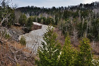
The Don River is a watercourse in southern Ontario that empties into Lake Ontario, at Toronto Harbour. Its mouth was just east of the street grid of the town of York, Upper Canada, the municipality that evolved into Toronto, Ontario. The Don is one of the major watercourses draining Toronto that have headwaters in the Oak Ridges Moraine.

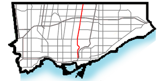
The Don Valley Parkway (DVP) is a municipal expressway in Toronto, Ontario, Canada, which connects the Gardiner Expressway in downtown Toronto with Highway 401. North of Highway 401, it continues as Highway 404. The parkway runs through the parklands of the Don River valley, after which it is named. It has a maximum speed limit of 90 km/h (56 mph) for its entire length of 15.0 km (9.3 mi). It is six lanes for most of its length, with eight lanes north of York Mills Road and four lanes south of Eastern Avenue. As a municipal road, it is patrolled by the Toronto Police Service.

<span class="mw-page-title-main">Leaside</span> Neighbourhood in Toronto, Ontario, Canada

Leaside (/'liːˌsaɪd/) is a neighbourhood in Toronto, Ontario, Canada. It is located northeast of Downtown Toronto, in the vicinity of Eglinton Avenue East and Bayview Avenue. The area takes its name from William Lea and the Lea family, who settled there in the early years of the 19th century. The area first developed as farmland along with Toronto through the 19th century. It was incorporated as a town in 1913. In 1967, it amalgamated with the township of East York to form the borough of East York. In 1998, it became part of the city of Toronto. It is one of the most expensive and exclusive neighbourhoods in the city.

<span class="mw-page-title-main">Don Valley Brick Works</span> Former quarry and industrial site in Toronto, Canada

The Don Valley Brick Works is a former quarry and industrial site located in the Don River Valley in Toronto, Ontario, Canada. The Don Valley Brick Works operated for nearly 100 years and provided bricks used to construct many well-known Toronto landmarks, such as Casa Loma, Osgoode Hall, Massey Hall, and the Ontario Legislature. Since the closure of the original factory, the quarry has been converted into a city park which includes a series of naturalized ponds, while the buildings have been restored and opened as an environmentally focused community and cultural centre by Evergreen, a national charity dedicated to restoring nature in urban environments.

<span class="mw-page-title-main">Thorncliffe Park</span> Neighbourhood in Toronto, Ontario, Canada

Thorncliffe Park is a neighbourhood in Toronto, Ontario, Canada, in the former Borough of East York.

<span class="mw-page-title-main">Bayview Avenue</span> Major north-south route in the Greater Toronto Area of Ontario

Bayview Avenue is a major north–south route in the Greater Toronto Area of Ontario. North of Toronto, in York Region, Bayview is designated as York Regional Road 34.

<span class="mw-page-title-main">Toronto Water</span>

Toronto Water is the municipal division of the City of Toronto under Infrastructure and Development Services responsible for the water supply network, and stormwater and wastewater management in Toronto, Ontario, Canada, as well as parts of Peel and York Regions.

<span class="mw-page-title-main">Leaside Bridge</span> Bridge in Toronto, Ontario, Canada

The Leaside Bridge, formerly the East York Leaside Viaduct, and officially commemorated as the Confederation Bridge, spans the Don River in the City of Toronto, Ontario. The Truss bridge carrying Millwood Road was built to connect the then Town of Leaside, including Thorncliffe Park, to the then Township of East York, and was completed on October 29, 1927. The construction time of only 10 months was record breaking at the time.

<span class="mw-page-title-main">Flemingdon Park</span> Neighbourhood in Toronto, Ontario, Canada

Flemingdon Park is a neighbourhood in Toronto, Ontario, Canada, located in the city's North York district. It is part of the Don Valley East federal and provincial electoral districts, and Ward 26: Don Valley East (South) municipally. In 2011, its population was 22,205. The average income was $66,784.

Friends of the Don East (FODE) is a non-governmental organization based in Toronto, Ontario, Canada. They are an environmental group whose goal is to preserve and protect natural areas in the Don River watershed.

<span class="mw-page-title-main">Markland Wood</span> Neighbourhood in Toronto, Ontario, Canada

Markland Wood is a residential neighbourhood in Toronto, Ontario, Canada. It is located west of the central core, in the former suburb of Etobicoke and is the westernmost residential community in Toronto along Bloor Street West. It's located on the border of Mississauga and bounded by Etobicoke Creek to the west, Elmcrest Creek to the east, Burnhamthorpe to the North, and surrounded by the Markland Wood Golf Club; approximately 2/3 is north of Bloor Street, and 1/3 south. Markland Wood is part of the Etobicoke Centre riding for federal and provincial governments and Ward 2 for the municipal council.

<span class="mw-page-title-main">Toronto ravine system</span> Geographical formations in Toronto, Canada

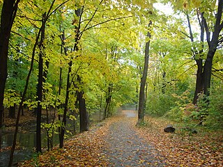
The Toronto ravine system is a distinctive feature of the city's geography, consisting of a network of deep ravines, which forms a large urban forest that runs through most of Toronto. The ravine system is the largest in any city in the world, with the Ravine and Natural Feature Protection Bylaw protecting approximately 110 square kilometres (42 sq mi) of public and privately-owned land. The ravine system has been presented as a central characteristic of the city, with the size of the ravine system leading Toronto to be described as "a city within a park".

<span class="mw-page-title-main">Port Lands</span> Neighbourhood in Toronto, Ontario, Canada

The Port Lands of Toronto, Ontario, Canada are an industrial and recreational neighbourhood located about 5 kilometres south-east of downtown, located on the former Don River delta and most of Ashbridge's Bay.

The Don Mills LRT was a proposed light rail line in Toronto, Ontario, Canada. It was part of the Transit City proposal announced March 16, 2007, to be operated by the Toronto Transit Commission (TTC). It was expected to cost approximately $675 million, with construction to begin in 2012, and an expected opening in 2016. It would have been the fifth of the seven Transit City lines to be complete after the Sheppard East, Finch West, Waterfront West, and Eglinton lines. Ridership was estimated to be 21.2 million trips in 2021.

<span class="mw-page-title-main">Thorncliffe Park Raceway</span>

Thorncliffe Park Raceway was a Toronto-area racetrack that operated from 1917 until 1952. It was located east of Millwood Road, south of Eglinton Avenue East and the CPR's railroad tracks. It was the first home of the Prince of Wales Stakes. The name is retained today by the Thorncliffe Park neighbourhood.
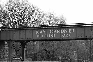
<span class="mw-page-title-main">Don Mills Trail</span>

The Don Mills Trail is a 3-kilometre (1.9 mi) cycling and walking trail in Toronto, Ontario, Canada. The trail runs south from York Mills Road, east of and roughly parallel to Leslie Street. The city built the trail on the roadbed of a former railway line, known as the Leaside Spur.

<span class="mw-page-title-main">Leaside station (Canadian Pacific Railway)</span> Railway station in Toronto, Ontario, Canada

Leaside station is a former railway station in Toronto that served Leaside and Thorncliffe Park. The Canadian Pacific Railway built the station in 1894 to serve the new community of Leaside, on a railway line leased from the Ontario and Quebec Railway.

References

  1. "Crothers Woods". City of Toronto. Archived from the original on 9 October 2015. Retrieved 23 December 2015.
  2. Crothers Caterpillar (Aerial photo), Leaside Historical Collection: Education, Community Affairs, Business/Industry, Volume 1, Leaside Public Library, undated.
  3. Planning Report for Proposed Development of 1101 Millwood Road, Malone Given Parsons Ltd, May 1983.
  4. "Don Valley Paper Mill".
  5. Statec Constulting Ltd (January 2010). "Hydro One Midtown Project Environmental Baseline Report" (PDF). Hydro One. p. 2.15. Archived from the original (PDF) on 23 December 2015. Retrieved 23 December 2015.
  6. Miller, Gavin, Crothers Woods: Environmentally Significant Area #133, Metro Toronto and Region Conservation Authority, June 1995.
  7. Care and Maintenance of Trails in the Don Valley, Bring Back the Don, 2004, "City of Toronto: Bring Back the Don, Care and maintenance of trails in the Don Valley". Archived from the original on 2007-09-30. Retrieved 2007-03-01..
  8. The Planning Partnership. "Crothers' Woods Trail Management Strategy" (PDF). City of Toronto. Archived from the original (PDF) on 7 June 2011. Retrieved 23 December 2015.