
The Frederick G. Gardiner Expressway, commonly known as the Gardiner Expressway or simply the Gardiner, is a partially at grade and elevated municipal expressway in Toronto, Ontario, Canada. Running close to the shore of Lake Ontario, it extends from the foot of the Don Valley Parkway (DVP) in the east, just past the mouth of the Don River, to the junction of Highway 427 and the Queen Elizabeth Way (QEW) in the west, for a total length of 18.0 kilometres (11.2 mi). East of Dufferin Street to just east of the Don River, the roadway is elevated for a length of 6.8 kilometres (4.2 mi), unofficially making it the longest bridge in Ontario.

Parkdale is a neighbourhood and former village in Toronto, Ontario, Canada, west of downtown. The neighbourhood is bounded on the west by Roncesvalles Avenue; on the north by the CP Rail line where it crosses Queen Street and Dundas Street; on the east by Dufferin Street from Queen Street south; and on the south by Lake Ontario. The original village incorporated an area north of Queen Street, east of Roncesvalles from Fermanagh east to the main rail lines, today known as part of the Roncesvalles neighbourhood. The village area was roughly one square kilometre in area. The City of Toronto government extends the neighbourhood boundaries to the east, south of the CP Rail lines, east to Atlantic Avenue, as far south as the CN Rail lines north of Exhibition Place, the part south of King Street commonly known as the western half of Liberty Village neighbourhood.
York is a district and former city within Toronto, Ontario, Canada. It is located northwest of Old Toronto, southwest of North York and east of the Humber River.
Weston is a neighbourhood and former town in Toronto, Ontario, Canada. The neighbourhood is situated in the northwest of the city, south of Highway 401 and Highway 400/Black Creek Drive, east of the Humber River, north of Eglinton Avenue, and west of Jane Street. The eponymous Weston Road, just north of Lawrence Avenue is the historic core of Weston, with many small businesses and services. Weston was incorporated as a village in the 19th century and was absorbed into the Borough of York in the late 1960s. York itself was amalgamated into Toronto in 1998. Weston is one of the few former towns and villages in Toronto located in a generally suburban setting, although it is contiguous with the inner city to the southeast along Weston Road. It is also one of the few not developed as a planned satellite town, as is the case with Leaside or New Toronto.
Bathurst Manor is a neighbourhood of Toronto, Ontario, Canada, located in northern Toronto in the former suburb of North York. It sits on a plateau bounded on the north by Finch Avenue West, on the west by Dufferin Street, on the east by the Don River, and on the south by Sheppard Avenue West. The area is also regarded as part of the Downsview postal area as designated by Canada Post. It is part of the former city of North York, which merged with five other municipalities and a regional government to form the new "City of Toronto" in 1998. It is part of the federal and provincial electoral district York Centre, and Toronto electoral ward 10: York Centre (East). In 2006, it had a population of 14,615.

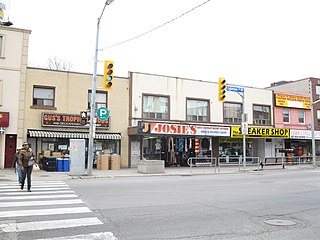
Dufferin Street is a major north–south street in Toronto, Vaughan and King, Ontario, Canada. It is a concession road, two concessions (4 km) west of Yonge Street. The street starts at Exhibition Place, continues north to Toronto's northern boundary at Steeles Avenue with some discontinuities and continues into Vaughan, where it is designated York Regional Road 53. The street is named for Frederick Hamilton-Temple-Blackwood, 1st Marquess of Dufferin and Ava, who served as Governor General of Canada from 1872 to 1878. Prior to 1878, the street was labelled as Western City Limits or Sideline Road south off Bloor. In 2003 and 2007, it was voted as one of "Ontario's Worst 20 Roads" in the Ontario's Worst Roads poll organized by the Canadian Automobile Association.
Tony Rizzo is a former politician in Ontario, Canada. He was a New Democratic member of the Legislative Assembly of Ontario from 1990 to 1995 who represented the central Toronto riding of Oakwood. He was also an alderman for the city of York from 1982 to 1990.

The Kingston Memorial Centre is a 3,300-seat multi-purpose arena located at 303 York Street in Kingston, Ontario, Canada. Opened in 1951, the Kingston Community Memorial Health and Recreation Centre was designed as a community sports and entertainment centre that would become a "living memorial" in remembrance of Kingstonians who gave their life in both world wars and the Korean War. The Memorial Centre lands and facilities include a war memorial, a large ice pad in the arena building, a new outdoor aquatic centre, agricultural barns, softball diamonds, a cinder track, off leash dog park and a linear park at the east, north and west perimeter of the property. Just east of the arena building was the International Hockey Hall of Fame (IHHOF) museum building at 277 York St. In July 2012, Kingston City Council approved the relocation of the collection on a short-term basis to the Invista Centre on Gardiners Road in Kingston. The existing building was found to have costly repair issues related to moisture penetration. It was demolished after the IHHOF moved to the Invista Centre in Kingston's west end.

The Distillery District is a commercial and residential district in Toronto, Ontario, Canada, east of downtown, which contains numerous cafés, restaurants, and shops housed within heritage buildings of the former Gooderham and Worts Distillery. The 13 acres (5.3 ha) district comprises more than forty heritage buildings and ten streets, and is the largest collection of Victorian-era industrial architecture in North America.

The Etobicoke Civic Centre in the Eatonville neighbourhood of Toronto, Ontario, Canada, once housed the municipal government of the former City of Etobicoke.
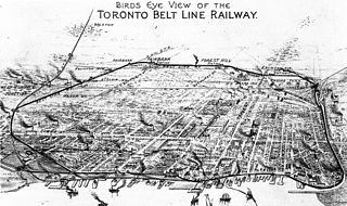
The Toronto Belt Line Railway was built during the 1890s in Toronto, Ontario, Canada. It consisted of two commuter railway lines to promote and service new suburban neighbourhoods outside of the then city limits. Both lines were laid as loops. The longer Don Loop ran north of the city limits, and the shorter Humber Loop ran west of the city limits. The railway was never profitable and ran for only two years. Today, as part of a rails-to-trails project, the Beltline Trail lies on the right-of-way of the Don Loop.
Fairbank is a neighbourhood in Toronto, Ontario, Canada. The area is centred on the intersection of Dufferin Street and Eglinton Avenue West. Fairbank includes the neighbourhoods of Briar Hill–Belgravia and Caledonia–Fairbank. The western border is the CNR lines. The northern and southern borders are the former borders of the City of York and the eastern border is Dufferin Street.
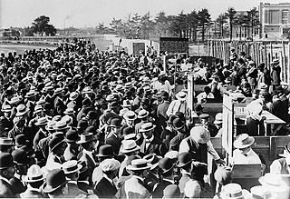
Dufferin Park Racetrack was a racetrack for thoroughbred horse races located on Dufferin Street in the city of Toronto, Ontario, Canada. It was demolished in 1955 and its stakes races moved to Woodbine Racetrack as part of a consolidation of racetracks in the Toronto area. The track was owned by Abe Orpen and his family after his death. Only 0.5 miles (0.80 km) in length, it was also called Little Saratoga. The site is now a shopping centre.
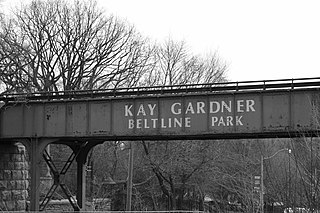
The Beltline Trail is a 9-kilometre (5.6 mi)-long cycling and walking rail trail in Toronto, Ontario, Canada. It consists of three sections, the York Beltline Trail west of Allen Road, the Kay Gardner Beltline Park from the Allen to Mount Pleasant Road, and the Ravine Beltline Trail south of Mount Pleasant Cemetery through the Moore Park Ravine. Built on the former right-of-way of the Toronto Belt Line Railway, the linear park passes through the neighbourhoods of Rosedale, Moore Park, Forest Hill, Chaplin Estates, and Fairbank.

Fairbank is an underground light rail transit (LRT) station under construction on Line 5 Eglinton, a new line that is part of the Toronto subway system. It will be located in the Fairbank neighbourhood at the intersection of Dufferin Street and Eglinton Avenue West. Destinations include the Fairbank neighbourhood and Fairbank Memorial Park. As of 2017, construction work related to the station was in progress, having been scheduled to begin in 2014. The station is scheduled to open in 2024.

Lycée Français Toronto (LFT) is a French international school in the Fairbank neighbourhood of Toronto. It serves levels PreK-12 and as of 2015 has 450 students. It was established in 1995. It is a part of the Agency For French Teaching Abroad (AEFE).

Earl Bales Park is a large park in Toronto, Ontario, Canada. The West Don River runs through it. It was named after Robert Earl Bales, a former reeve of the North York township. The park contains a ski centre, community centre, dog park, amphitheatre and holocaust memorial. There are many forested trails going through the park, as well as a 3.2 hectares stormwater management pond.


