
Leaside (/'liːˌsaɪd/) is a neighbourhood in Toronto, Ontario, Canada. It is located northeast of Downtown Toronto, in the vicinity of Eglinton Avenue East and Bayview Avenue. The area takes its name from William Lea and the Lea family, who settled there in the early years of the 19th century. The area first developed as farmland along with Toronto through the 19th century. It was incorporated as a town in 1913. In 1967, it amalgamated with the township of East York to form the borough of East York. In 1998, it became part of the city of Toronto. It is one of the most expensive and exclusive neighbourhoods in the city.

North Toronto is a former town and informal district located in the northern part of the Old Toronto district in Toronto, Ontario, Canada. Currently occupying a geographically central location within the city of Toronto, the Town of North Toronto was incorporated in 1890, when much of the area was still farmland, and annexed by Toronto in 1912. The name is still used to refer to the area in general, although Yonge–Eglinton and Midtown Toronto are officially used.

Kilwinning is a town in North Ayrshire, Scotland. It is on the River Garnock, north of Irvine, about 21 miles (34 km) southwest of Glasgow. It is known as "The Crossroads of Ayrshire". Kilwinning was also a Civil Parish. The 2001 Census recorded the town as having a population of 15,908. The estimated population in 2016 was 16,460.
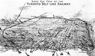
The Toronto Belt Line Railway was built during the 1890s in Toronto, Ontario, Canada. It consisted of two commuter railway lines to promote and service new suburban neighbourhoods outside of the then city limits. Both lines were laid as loops. The longer Don Loop ran north of the city limits, and the shorter Humber Loop ran west of the city limits. The railway was never profitable and ran for only two years. Today, as part of a rails-to-trails project, the Beltline Trail lies on the right-of-way of the Don Loop.

Davisville Village is a neighbourhood of Toronto, Ontario, Canada. It is located near the intersection of Davisville Avenue and Yonge Street. There is a subway station named Davisville at this intersection. The area directly abuts Mount Pleasant Cemetery, and has many massive apartment and condominium complexes built between the 1970s and the 2000s, as well as a number of office buildings. The area is within Midtown Toronto between St Clair and Eglinton. Davisville Village is represented at Toronto City Council by Councillor Josh Matlow.

The Markham Centennial Centre is a 2,300-seat arena located in Markham, Ontario, north of Toronto.

Rosedale Field was a grandstand stadium located in Rosedale Park at 20 Scholfield Avenue, Toronto, Ontario, Canada.

Lambton is a neighbourhood in the city of Toronto, Ontario, Canada. It is situated on the east bank of the Humber River north and south of Dundas Street West. It is bounded on the north by Black Creek, on the east by Jane Street and on the south by St. Mark's Road. The area west of Gooch Avenue and south of Dundas Street West is also known as "Warren Park", the name of the housing sub-division built in the 1950s. The portion south of Dundas Street West is within the 'Lambton Baby Point' neighbourhood as defined by the City of Toronto.
Midtown is one of four central business districts outside the city's downtown core of Toronto, Ontario, Canada. Located in the north of Old Toronto, its borders are roughly defined by St. Clair Avenue to the south and Eglinton Avenue or Lawrence Avenue to the north, Bayview Avenue to the east and Dufferin Street to the west. The central neighbourhood of the area is Yonge–Eglinton.

Eglinton Castle was a large Gothic castellated mansion in Kilwinning, North Ayrshire, Scotland.

The Victoria Skating Rink was an indoor ice skating rink located in Montreal, Quebec, Canada. Opened in 1862, it was described at the start of the twentieth century to be "one of the finest covered rinks in the world". The building was used during winter seasons for pleasure skating, ice hockey and skating sports on a natural ice rink. In summer months, the building was used for various events, including musical performances and horticultural shows. It was the first building in Canada to be electrified.
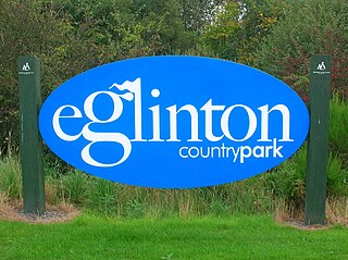
Eglinton Country Park is located on the grounds of the old Eglinton Castle estate in Kilwinning, North Ayrshire, Scotland. Eglinton Park is situated in the parish of Kilwinning, part of the former district of Cunninghame, and covers an area of 400 ha ([98 acres ] of which are woodland. The central iconic feature of the country park is the ruined Eglinton Castle, once home to the Eglinton family and later the Montgomeries, Earls of Eglinton and chiefs of the Clan Montgomery. Eglinton Country Park is managed and maintained by North Ayrshire Council and its Ranger Service.

The Granite Club is a private social and athletic club in Toronto, Ontario, Canada. Founded in 1875, it has a long history of sports competition. It is located at 2350 Bayview Avenue, north of midtown Toronto.
Wheeling Park, formerly Hornbrook's Park, is a 406 acres (1.64 km2) park located in Wheeling, West Virginia. The park first opened in 1925. The park was originally only open during the warmer months. In 1959, the addition of an ice rink turned the park into a year-round facility.

Ramsden Park is a public park located at 1020 Yonge Street in Toronto, Ontario, Canada, with access via Ramsden Park Road. and Pears Avenue. With an area of 13.7 acres, Ramsden Park is one of the largest in downtown Toronto. It features playgrounds, basketball courts, hockey rinks and a small skateboarding feature.
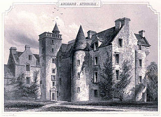
Auchans Castle, House, House of Auchans or Old Auchans, is a mock military mansion, Category A listed, T-plan building of a late 16th-century date converted to the L-plan during the early-to-mid-17th century; its ruins stand about 1 km W of Dundonald, South Ayrshire, Scotland. Parish of Dundonald. It was held at various times by the Wallace, Cochrane and Montgomerie families.
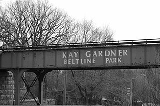
The Beltline Trail is a 9-kilometre (5.6 mi)-long cycling and walking rail trail in Toronto, Ontario, Canada. It consists of three sections, the York Beltline Trail west of Allen Road, the Kay Gardner Beltline Park from the Allen to Mount Pleasant Road, and the Ravine Beltline Trail south of Mount Pleasant Cemetery through the Moore Park Ravine. Built on the former right-of-way of the Toronto Belt Line Railway, the linear park passes through the neighbourhoods of Rosedale, Moore Park, Forest Hill, Chaplin Estates, and Fairbank.
McCowan District Park is a 8.1-hectare (20-acre) recreational park in the Eglinton East neighbourhood of Scarborough, Toronto, Ontario, Canada. The park is located along McCowan Road, south of the Lakeshore East commuter rail line of GO Transit.

