
Harbourfront is a neighbourhood on the northern shore of Lake Ontario within downtown Toronto, Ontario, Canada. Part of the Toronto waterfront, Harbourfront extends from Bathurst Street in the west, along Queens Quay, with its ill-defined eastern boundary being either Yonge Street or York Street. Its northern boundary is the Gardiner Expressway. Much of the district was former water lots filled in during the early 1900s to create a larger harbour district. After shipping patterns changed and the use of the Toronto Harbour declined, the area was converted from industrial uses to a mixed-use district that is mostly residential and leisure.

The Toronto waterfront is the lakeshore of Lake Ontario in the city of Toronto, Ontario, Canada. It spans 46 kilometres between the mouth of Etobicoke Creek in the west and the Rouge River in the east.

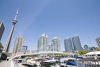
Toronto Harbour or Toronto Bay is a natural bay on the north shore of Lake Ontario, in Toronto, Ontario, Canada. Today, the harbour is used primarily for recreational boating, including personal vessels and pleasure boats providing scenic or party cruises. Ferries travel from docks on the mainland to the Islands, and cargo ships deliver aggregates and raw sugar to industries located in the harbour. Historically, the harbour has been used for military vessels, passenger traffic and cargo traffic. Waterfront uses include residential, recreational, cultural, commercial and industrial sites.
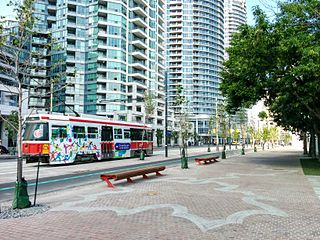
Queens Quay is a prominent street in the Harbourfront neighbourhood of Toronto, Ontario, Canada. The street was originally commercial in nature due to the many working piers along the waterfront; parts of it have been extensively rebuilt in since the 1970s with parks, condominiums, retail, as well as institutional and cultural development.

Canada Malting Silos is one of two remaining silos in Toronto's Harbourfront in Ontario, Canada. Located at the foot of Bathurst Street at Bathurst Quay, the silos were built in 1928 to store malt for the Canada Malting Company. It was an important work of industrial architecture, as grain elevators had long been built out of wood, and thus were at great danger of fire. The concrete malting towers were an innovation, and the stark functionalism of the prominent building was an early influence on modernist architecture. A round office was added in 1944 and glass office was built in the original construction in 1928. The main silos, 15 in all, are 120 feet high and additional storage bins built in 1944 are 150 feet high.

Queen's Quay Terminal is a condominium apartment, office and retail complex in the Harbourfront neighbourhood in Toronto, Ontario, Canada. It was originally built in 1927 as a marine terminal with office, warehouse and cold-storage facilities. When shipping to Toronto declined in the 1960s and 1970s, the building was bought by the Government of Canada to be repurposed along with a section of the industrial waterfront. The Terminal Building itself was rebuilt in the 1980s with the addition of four floors of residential above the original facility, which was converted into retail and office uses. The cold storage wing was demolished and its plant building became The Power Plant gallery and Harbourfront Centre Theatre.

Downtown Toronto is the main city centre of Toronto, Ontario, Canada. Located entirely within the district of Old Toronto, it is approximately 16.6 square kilometres in area, bounded by Bloor Street to the northeast and Dupont Street to the northwest, Lake Ontario to the south, the Don Valley to the east, and Bathurst Street to the west. It is also the home of the municipal government of Toronto and the Government of Ontario.
Amsterdam Bridge is a bridge on the waterfront in Toronto, Ontario, Canada. The steel structure is a cable footbridge that crosses over the Simcoe Street Slip from York Quay to Rees Street Slip.
Waterfront Toronto is an organization that oversees revitalization projects along the Toronto waterfront. Established in 2001 as a public–public partnership between the City of Toronto, Province of Ontario and Government of Canada, the organization is administering several blocks of land redevelopment projects surrounding Toronto Harbour and various other initiatives to promote the revitalization of the area, including public transit, housing developments, brownfield rehabilitation, possible removal of the Gardiner Expressway in the area, the Martin Goodman Trail and lakeshore improvements, and naturalization of the Don River. Actual development of the projects is done by other entities, primarily private corporations. The projects include a series of wavedeck walkways and gathering places designed by West 8 and DTAH.

The Toronto Harbour Commission (THC) was a joint federal-municipal government agency based in Toronto, Ontario, Canada. The agency managed Toronto Harbour as well as being responsible for major works along the Toronto waterfront. It built both Malton Airport and the Toronto Island Airport in 1939. The agency was founded in 1911 and operated until 1999 when the port operations were transferred to the new Toronto Port Authority (TPA), now PortsToronto.
Maple Leaf Mills Silos was one of two silo or grain elevator complexes that were built in the area between Spadina Quay and Maple Leaf Quay, on Toronto Harbour, in Toronto, Ontario, Canada. It was one of three "monumental" silo complexes that dominated the city's waterfront.

The Toronto Waterfront Wavedecks are a series of wooden structures constructed on the waterfront of Toronto, Ontario, Canada, as part of the revitalization of the central waterfront. Waterfront Toronto committed to constructing a series of unique wooden wavedecks along the water's edge for the 3.5 km area running from Bathurst Street to Parliament Street. All the WaveDecks are accessible from the southside of Queens Quay.

Harbourfront Centre is a cultural organization on the waterfront of Toronto, Ontario, Canada, situated at 235 Queens Quay West. Established as a crown corporation in 1972 by the Government of Canada to create a waterfront park, it became a non-profit organization in 1991. Funding comes from corporate sponsors, government grants, individual donors and entrepreneurial activities. Harbourfront Centre has a seating capacity of 2,000.
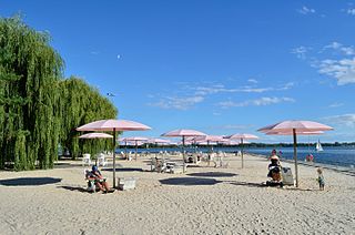
Sugar Beach is an urban beach park in Toronto, Ontario, Canada, that opened in 2010. It is located across from Redpath Sugar Refinery in Toronto's eastern East Bayfront. Like HTO Park to the west, the beach is not meant for wading or swimming in Lake Ontario, but rather functions as a waterfront public space for relaxation, leisure, and social activities. It cost $14 million.
East Bayfront, or the East Bayfront Precinct, is an emerging neighbourhood in Toronto, Ontario, Canada. It is currently undergoing a transformation from industrial use to mixed-use as part of Waterfront Toronto's plans to create a residential and commercial district urban core near the lake.
East Bayfront LRT, also known as the Waterfront East LRT, is a planned Toronto streetcar line that would serve the East Bayfront and Port Lands areas in Toronto, Ontario, Canada. It would run from Union station under Bay Street and along Queens Quay and Cherry Street to a new Villiers Loop along Commissioners Street east of Cherry Street on Villiers Island. It would complement the existing 509 Harbourfront service that connects Union Station to Queens Quay west of Bay Street. Longer-term plans are to extend the East Bayfront line from Cherry and Commissioners Streets to the planned East Harbour Transit Hub along GO Transit's Lakeshore East line and the planned Ontario Line.
The following outline is provided as an overview of and topical guide to Toronto:
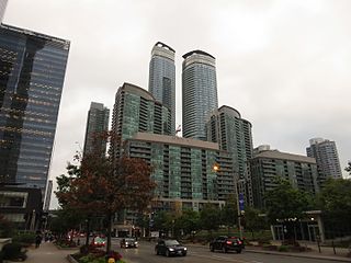
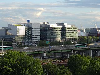
South Core is a neighbourhood located in downtown Toronto, Ontario, Canada. The South Core occupies the eastern portions of the Railway Lands. The remodeling and restoration of Union Station and the construction of a new wave of business and condominium towers is central to this area's forecast growth.
Forecasters expect the downtown population to grow 80 per cent to 130,000 by 2031. With the financial district just to the north and the new high-rise South Core on the other side, Union is right at the centre.
Harbour Square Park is a park in Toronto, Ontario, Canada right on the Toronto harbour. It is next to the Harbour Square condos, the Jack Layton Ferry Terminal and the Westin Harbour Castle. It is south of Queens Quay and adjacent to the Queens Quay streetcar station. It contains a boardwalk and a permanent public art installation.


