Cherry Beach

Last updated
Cherry Beach
Cherry Beach Park (37949679394).jpg
The life guard station on Cherry Beach
Cherry Beach
TypePublic beach
Location Toronto, Ontario
Coordinates 43°38′13″N79°20′40″W / 43.63694°N 79.34444°W / 43.63694; -79.34444
Created1930s
Operated by Toronto Parks
Website

Cherry Beach (originally Clarke Beach Park) is a lakeside beach park located at the foot of Cherry Street just south of Unwin Avenue in Toronto, Ontario, Canada. It is on Toronto's outer harbour just east of the Eastern Gap. It was once connected with Toronto Islands as part of the former peninsula before 1852. [1]

Contents

Despite its location at the tip of Toronto's formerly heavily industrial Port Lands area, Cherry Beach is a popular gathering place. There is no boardwalk and much of the surrounding areas is marshland or leftover grounds from what was once commercial industry and factory grounds. Recently the park has undergone improvements which includes a paved entrance way and a renovated washroom and swimming change room facilities. It has change rooms for bathers and barbecue areas for picnickers. It also has an off-leash area for dog walkers. The Martin Goodman Trail passes through the park.

In summer, the beach water is generally calm, and slightly warmer than other Toronto beaches along the lake shore, as its shallow water is sheltered by the Leslie Street Spit from direct surges of Lake Ontario.

History

Bathers at Cherry Beach prior to construction of Leslie Street spit, 1935 Bathers at Cherry Beach prior to the construction of the Leslie Street spit -a.jpg
Bathers at Cherry Beach prior to construction of Leslie Street spit, 1935
Martin Goodman Trail passes through Cherry Beach Park between the beach and wooded areas Cherry Beach Park (38635593192).jpg
Martin Goodman Trail passes through Cherry Beach Park between the beach and wooded areas

The area that comprises Cherry Beach today was originally a marsh and sandbar that has been land filled. [2] It was a place of spiritual significance for many indigenous people. [2] [ better source needed ]

In the 1850s, settlers established a community in the area. The area was called Fisherman's Island and included a commercial fishery and church. People would travel to and from the mainland of Toronto by boat or across a breakwater that was built in 1882. [3]

The beach park was originally named Clarke Beach Park after Harry Clarke, an alderman who was responsible for creating the park in the early 1930s. [4] In 1974, the Toronto's Central Waterfront Planning proposed to eliminate Cherry Beach for industrial use. [5] In 2003, the city officially renamed it to Cherry Beach which was already the common name among locals. [6] In 2020, a group of local residents issued a collective statement criticizing a feasibility study by Waterfront Toronto which considered providing water taxis access to the beach. [7]

Ecology

For many years it was one of the few Toronto beaches that was clean enough for swimming, windsurfing and kitesurfing; It typically meets high water quality, environmental and safety standards; [8] however, a 2012 environmental assessment found that the concentration of lead and zinc in the soil at Cherry Beach is above guidelines, which is attributed to previous industrial use of the area. [2] The only other major stands of cottonwoods in the Toronto area beyond the Toronto Islands are located at Cherry Beach. [1]

Cherry Beach Sports Fields

A wooded area by the beach has been turned into soccer fields, children's play structure and a metered parking area.

In 2006 a pair of soccer fields were completed on land that had formerly been part of the greenbelt, at 275 Unwin Avenue. [9] [10] The fields were surfaced in astroturf and built to FIFA standards, and games of the 2007 FIFA Jr championship were to be played there. During the environmental assessment the site was found to be heavily contaminated by heavy metals, hydrocarbons and PCBs.[ citation needed ] The soccer field was described as a "transitional" facility, as most of the land on either side of Unwin was underutilized city land that could be repurposed to sport facilities even though it was contaminated.

Toronto FC used the soccer pitches for practice while their own dedicated training facilities were being constructed at Downsview Park. [11]

Pukka Orchestra had a local radio hit in 1984 with the song "Cherry Beach Express." The song's name is a euphemism for the alleged police brutality committed on gay, indigenous, and homeless people at the beach between the 1940s and 1990s. [12] [13] [14] [15] The Toronto police tried to have the song banned. [16]

Parts of the music video for the Alessia Cara song "Wild Things" were filmed at Cherry Beach. [17]

Parts of the film Silent Hill: Revelation 3D were filmed at Cherry Beach. [18]

Toronto punk band Career Suicide named a 2008 EP after Cherry Beach.[ citation needed ]

See also

Related Research Articles

<span class="mw-page-title-main">Toronto Islands</span> Chain of islands in Lake Ontario

The Toronto Islands are a chain of 15 small islands in Lake Ontario, south of mainland Toronto, Ontario, Canada.

<span class="mw-page-title-main">Harbourfront, Toronto</span> Neighbourhood in Toronto, Ontario, Canada

Harbourfront is a neighbourhood on the northern shore of Lake Ontario within the downtown core of the city of Toronto, Ontario, Canada. Part of the Toronto waterfront, Harbourfront extends from Bathurst Street in the west, along Queens Quay, with its ill-defined eastern boundary being either Yonge Street or York Street. Its northern boundary is the Gardiner Expressway. Much of the district was former water lots filled in during the early 1900s to create a larger harbour district. After shipping patterns changed and the use of the Toronto harbour declined, the area was converted from industrial uses to a mixed-use district that is mostly residential and leisure.

<span class="mw-page-title-main">Toronto waterfront</span> Shore of Lake Ontario in Toronto, Canada

The Toronto waterfront is the lakeshore of Lake Ontario in the city of Toronto, Ontario, Canada. It spans 46 kilometres between the mouth of Etobicoke Creek in the west and the Rouge River in the east.

<span class="mw-page-title-main">Toronto Harbour</span> Bay on the north shore of Lake Ontario, in Toronto, Ontario, Canada

Toronto Harbour or Toronto Bay is a natural bay on the north shore of Lake Ontario, in Toronto, Ontario, Canada. Today, the harbour is used primarily for recreational boating, including personal vessels and pleasure boats providing scenic or party cruises. Ferries travel from docks on the mainland to the Islands, and cargo ships deliver aggregates and raw sugar to industries located in the harbour. Historically, the harbour has been used for military vessels, passenger traffic and cargo traffic. Waterfront uses include residential, recreational, cultural, commercial and industrial sites.

<span class="mw-page-title-main">Leslie Street Spit</span> Human-made headland in Ontario, Canada

The Leslie Street Spit, or officially the Outer Harbour East Headland, is a human-made headland in Toronto, Ontario, Canada, extending from the city's east end in a roughly southwesterly direction into Lake Ontario. It is about 5 kilometres (3 mi) long. The Spit is the result of five decades of lakefilling by the Toronto Port Authority. It was conceived as an extension of Toronto Harbour, and has evolved into a largely passive recreation area. Naturalization had not been planned but the process is now actively managed by the Toronto and Region Conservation Authority. A large portion of it is classified as an Environmentally Sensitive Area (ESA) and it is recognized as an Important Bird Area.

<span class="mw-page-title-main">Downsview Park</span> Urban park in Ontario

Downsview Park(French: Parc Downsview) is a large urban park located in the Downsview neighbourhood of Toronto, Ontario, Canada. The park's name is officially bilingual due to it being federally owned and managed, and was first home to de Havilland Canada, an aircraft manufacturer, and later was a Canadian Forces base. The park still contains Downsview Airport. In 1999, the Government of Canada declared it as "Canada's first urban national park". However, unlike the Rouge National Urban Park in eastern Toronto, Downsview Park is managed by the federal Crown corporation Canada Lands Company rather than Parks Canada.

<span class="mw-page-title-main">Sunnyside, Toronto</span> Lakefront district

Sunnyside is a lakefront district in Toronto, Ontario, Canada. It includes a beach and park area along Lake Ontario's Humber Bay, from west of Exhibition Place to the mouth of the Humber River. The area has several recreation uses, including rowing clubs, sports clubs, picnic areas, playgrounds, a nightclub, a bathing pavilion and public pool. The area is a 3 kilometres (1.9 mi) long strip along the lakeshore, bounded by the Gardiner Expressway and rail lines, which separate it from the Parkdale, Roncesvalles and Swansea neighbourhoods to the north. The name originates in a local farm owned by John Howard, which was situated just to the north, on the location of the current St. Joseph's Health Centre hospital.

<span class="mw-page-title-main">Waterfront Trail</span> Pedestrian and bicycle trail system in Ontario, Canada

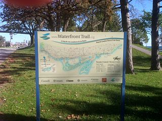
Stretching over 3600 km from Prince Township, west of Sault Ste. Marie, to the Quebec border, the Great Lakes Waterfront Trail is a signed route of interconnecting roads and off-road trails joining over 150 communities and First Nations along the Canadian shores of the Great Lakes and St. Lawrence River. A celebration of nature and culture, the Great Lakes Waterfront Trail is part of a strategy to protect and connect people to the largest group of freshwater lakes on earth. It is a legacy project of the Waterfront Regeneration Trust, a charity, and its community partners. Through Toronto, the trail is called the Martin Goodman Trail. The Waterfront Trail is also used by commuters in parts of Southern Ontario.

<span class="mw-page-title-main">Toronto Parks, Forestry and Recreation Division</span>

Toronto Parks, Forestry & Recreation (PFR) is the division of Toronto's municipal government responsible for maintaining the municipal park system and natural spaces, regulation of and provision of urban forestry services, and the delivery of recreational programming in city-operated facilities.

<span class="mw-page-title-main">Keating Channel</span> River in Ontario, Canada

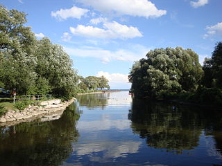
The Keating Channel is a 1,000-metre (3,300 ft) long waterway in Toronto, Ontario, Canada. It connects the Don River to inner Toronto Harbour on Lake Ontario. The channel is named after Edward Henry Keating (1844-1912), a city engineer (1892-1898) who proposed the creation of the channel in 1893. The channel was built to connect Ashbridge's Bay to the harbour; later, the Don was diverted into the channel, and its river mouth infilled in the early 1910s.

<span class="mw-page-title-main">Port Lands</span> Neighbourhood in Toronto, Ontario, Canada

The Port Lands of Toronto, Ontario, Canada are an industrial and recreational neighbourhood located about 5 kilometres south-east of downtown, located on the former Don River delta and most of Ashbridge's Bay.

<span class="mw-page-title-main">Waterfront Toronto</span> Organization that oversees revitalization projects along the Toronto waterfront

Waterfront Toronto is an organization that oversees revitalization projects along the Toronto waterfront. Established in 2001 as a public–public partnership between the City of Toronto, Province of Ontario and Government of Canada, the organization is administering several blocks of land redevelopment projects surrounding Toronto Harbour and various other initiatives to promote the revitalization of the area, including public transit, housing developments, brownfield rehabilitation, possible removal of the Gardiner Expressway in the area, the Martin Goodman Trail and lakeshore improvements, and naturalization of the Don River. Actual development of the projects is done by other entities, primarily private corporations. The projects include a series of wavedeck walkways and gathering places designed by West 8 and DTAH.

<span class="mw-page-title-main">Sugar Beach</span> Urban beach in Toronto, Ontario, Canada

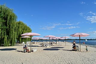
Sugar Beach is an urban beach park in Toronto, Ontario, Canada, that opened in 2010. It is located across from Redpath Sugar Refinery in Toronto's eastern East Bayfront. Like HTO Park to the west, the beach is not meant to allow wading or swimming in Lake Ontario, but rather functions as a waterfront public space for relaxation, leisure, and social activities. It cost $14 million.

East Bayfront LRT, also known as the Waterfront East LRT, is a planned Toronto streetcar line that would serve the East Bayfront and Port Lands areas in Toronto, Ontario, Canada. It would run from Union station under Bay Street and along Queens Quay and Cherry Street to a new Villiers Loop along Commissioners Street east of Cherry Street on Villiers Island. It would complement the existing 509 Harbourfront service that connects Union Station to Queens Quay west of Bay Street. Longer-term plans are to extend the East Bayfront line from Cherry and Commissioners Streets to the planned East Harbour Transit Hub along GO Transit's Lakeshore East line and the planned Ontario Line.

<span class="mw-page-title-main">Cherry Street (Toronto)</span> Thoroughfare in Toronto, Ontario

Cherry Street is a north-south arterial roadway in the eastern downtown of Toronto, Ontario, Canada. It is situated in a former industrial area, that is now the site of redevelopment. It connects Eastern Avenue south to Lake Shore Boulevard, then to the Toronto Port Lands district, and terminates at Lake Ontario at Cherry Beach.

<span class="mw-page-title-main">Marie Curtis Park</span> Public park in Toronto, Canada

Marie Curtis Park is a public park in Toronto, Ontario, Canada. It is located at the mouth of the Etobicoke Creek on Lake Ontario in the Long Branch neighbourhood. Marie Curtis Park was built after the devastating floods of Hurricane Hazel in 1954 destroyed 56 homes and cottages on the site, leaving 1,868 persons homeless and 81 dead. It is named after Marie Curtis, the reeve of Long Branch at the time of its construction. Long Branch at the time was a separate village; it's now amalgamated into the City of Toronto government.

<span class="mw-page-title-main">Ashbridge's Bay</span>

Ashbridges Bay is a bay and park in Toronto, Ontario, Canada. It is located along Lake Shore Boulevard next to Woodbine Beach in the Beaches. The Martin Goodman Trail and boardwalk run through the park along the bay. The boardwalk runs 3 kilometres (1.9 mi) from Ashbridges Bay in the west to the R. C. Harris Water Treatment Plant in the east along Lake Ontario. It was once part of the marsh that lay east of Toronto Islands and Toronto Harbour.

<span class="mw-page-title-main">Villiers Island</span> Island in Toronto, Ontario, Canada

Villiers Island is a 22-hectare (54-acre) area in Toronto's Port Lands being converted to an island. The project is a part of Port Lands Flood Protection Project by Waterfront Toronto. To prevent flooding from the Don River, a channel is being created to extend the river south and then west into Toronto Harbour providing another outlet and a more natural mouth for the Don River. The new channel effectively creates the island, which is also bounded by the Keating Channel and Toronto Harbour. Mixed-use residential development is planned for Villiers Island.

<span class="mw-page-title-main">East Chinatown, Toronto</span> Neighbourhood in Toronto, Ontario, Canada

East Chinatown is a Chinese neighbourhood located in the city of Toronto's east end in Riverdale and one of the several Chinatowns in Toronto. It was formed during the early 1970s and is centred on Gerrard Street East between Broadview Avenue and Carlaw Avenue.

References

  1. 1 2 Kidd, Joanna (1999–2004). "Nature on the Toronto Islands : an explorer's guide | WorldCat.org" (PDF). search.worldcat.org. Retrieved 2024-01-15.
  2. 1 2 3 Dakane, Abdulkadir. Bioaccessibility of metals in Toronto city parks. Royal Roads University, 2012. Link
  3. "found objects". Waterfront Toronto. Retrieved 2024-01-15.
  4. "Popular Toronto beach is all that's left of a lost island community killed by industry". www.blogto.com. Retrieved 2024-01-15.
  5. Fan, Larissa. Temporary landscape: the Port of Toronto. Library and Archives Canada= Bibliothèque et Archives Canada, Ottawa, 2009. Link
  6. Renaming Clarke Beach Park to Cherry Beach
  7. Johnson, Ron (2020-11-19). "COVID-19 second wave Q & A with Dr. Phil Shin of North York General Hospital | TRNTO.com". Streets Of Toronto. Retrieved 2024-01-08.
  8. "Cherry Beach Clarke Beach Park, Parks, Forestry & Recreation". toronto.ca. City of Toronto. Archived from the original on July 27, 2017. Retrieved December 6, 2016. Cherry Beach typically achieves annual blue flag certification. This international eco-label is awarded to beaches that meet high water quality, environmental and safety standards.
  9. "Port Lands Transitional Sports Fields Public Meeting" (PDF). Waterfront Toronto. 2006-09-13. Retrieved 2012-03-18.
  10. Ben Knight (2009-05-21). "Deep in the shadows". Onward Soccer. Archived from the original on 2013-07-04. Retrieved 2012-03-18.
  11. "Toronto FC to build training facility at Downsview Park". The Sports Network. 2011-04-18. Retrieved 2012-03-18. The Toronto first team has been practising on an artificial turf field at Cherry Beach while the academy sides have worked out on the turf at Lamport Stadium.
  12. "Pukka Orchestra, Cherry Beach Express". AudioDorks. Retrieved August 28, 2020.
  13. "The top 5 Toronto urban myths". www.blogto.com. Retrieved 2024-01-08.
  14. Reporter, Rachel Mendleson Staff (2013-08-20). "Missing Plaque Project unveils Toronto's untold history". Toronto Star. Retrieved 2024-01-15. ...the poster recalls in a few short sentences the beatings that were allegedly inflicted on gays and aboriginals and other "undesirables" until the 1990s.
  15. Warner, Thomas E. (2002-01-01). Never Going Back: A History of Queer Activism in Canada. University of Toronto Press. p. 38. ISBN   978-0-8020-8460-6. Toronto police had a long history of harassing gays and lesbians. During the 1940s and 1950s, they systematically rounded up lesbians, took them to a secluded spot at Cherry Beach, beat them up, and ten left them to fend for themselves.
  16. "Toronto Urban Legends: Cherry Beach Express". Torontoist , October 3, 2012.
  17. Archived at Ghostarchive and the Wayback Machine : "Wild Things- Official Video (BEHIND THE SCENES)". YouTube .
  18. "Scene: Foggy Film Shoot in the Port Lands". Torontoist . St. Joseph Communications. 8 April 2011. Archived from the original on 29 July 2013. Retrieved 28 September 2011.