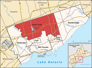
North York is a former township and city and is now one of the six administrative districts of Toronto, Ontario, Canada. It is located in the northern area of Toronto, centred around Yonge Street, north of Ontario Highway 401. It is bounded by York Region to the north at Steeles Avenue, on the west by the Humber River, on the east by Victoria Park Avenue. Its southern boundary corresponds to the northern boundaries of the former municipalities of Toronto: York, Old Toronto and East York. As of the 2016 Census, the district has a population of 644,685.

Thorncliffe Park is a neighbourhood in Toronto, Ontario, Canada, in the former Borough of East York.
Bathurst Manor is a neighbourhood of Toronto, Ontario, Canada, located in northern Toronto in the former suburb of North York. It sits on a plateau bounded on the north by Finch Avenue West, on the west by Dufferin Street, on the east by the Don River, and on the south by Sheppard Avenue West. The area is also regarded as part of the Downsview postal area as designated by Canada Post. It is part of the former city of North York, which merged with five other municipalities and a regional government to form the new "City of Toronto" in 1998. It is part of the federal and provincial electoral district York Centre, and Toronto electoral ward 10: York Centre (East). In 2006, it had a population of 14,615.
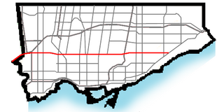
Eglinton Avenue is a major east–west arterial thoroughfare in Toronto and Mississauga in the Canadian province of Ontario. The street begins at Highway 407 at the western limits of Mississauga, as a continuation of Lower Baseline in Milton. It traverses the midsection of both cities and ends at Kingston Road. Eglinton Avenue is the only street to cross all six former cities and boroughs of Metropolitan Toronto.

Bathurst Street is a main north–south thoroughfare in Toronto, Ontario, Canada. It begins at an intersection of the Queens Quay roadway, just north of the Lake Ontario shoreline. It continues north through Toronto to the Toronto boundary at Steeles Avenue. It is a four-lane thoroughfare throughout Toronto. The roadway continues north into York Region where it is known as York Regional Road 38.
The Toronto and Region Conservation Authority (TRCA) is a conservation authority in southern Ontario, Canada. It owns about 16,000 hectares of land in the Toronto region, and it employs more than 400 full-time employees and coordinates more than 3,000 volunteers each year. TRCA's area of jurisdiction is watershed-based and includes 3,467 square kilometres (1,339 sq mi) – 2,506 on land and 961 water-based in Lake Ontario. This area comprises nine watersheds from west to east – Etobicoke Creek, Mimico Creek, Humber River, Don River, Highland Creek, Petticoat Creek, Rouge River, Duffins Creek and Carruthers Creek.

Toronto Parks, Forestry & Recreation (PFR) is the division of Toronto's municipal government responsible for maintaining the municipal park system and natural spaces, regulation of and provision of urban forestry services, and the delivery of recreational programming in city-operated facilities.

The Anne & Max Tanenbaum Community Hebrew Academy of Toronto, also known as CHAT and TanenbaumCHAT, is a private Jewish high school in Toronto, Ontario, established in 1960. As of 2012, it was the largest private high school in Canada. A second campus of TanenbaumCHAT existed from 2000 to 2017 in the York Region, known as the Kimel Family Education Centre.
Uplands Ski Centre is a small ski area located in Thornhill, Ontario, just north of Toronto, Ontario and operated by the Uplands Golf Club. It has one ski lift—a quad chair starting in the 2012-2013 season. It has four runs averaging 300 m in length and has about 100 feet of vertical Uplands is open from 9:00 a.m. (Friday-Sunday) or noon (Monday-Thursday) until 6:00 p.m. (Weekends) or 9:00 p.m. (Weekdays).

Lawrence Manor is a neighbourhood in the city of Toronto, Ontario, Canada. This neighbourhood is bounded by Bathurst Street on the east, Highway 401 to the north, the Allen to the west, and Lawrence Avenue to the south. The western side of the area borders along Bathurst Heights and the large public housing project.

Clanton Park is a neighbourhood in Toronto, Ontario, Canada. Located in the district of North York, it is part of federal and provincial electoral district York Centre, and Toronto electoral wards 9: York Centre (West) and 10: York Centre (East). In 2016, it had a population of 16,472, a 12.7% rise from 2011.

Lansing is a neighbourhood in Toronto, Ontario, Canada. It originated as a minor settlement of a store, other services and a post office at the corner of Yonge Street and Sheppard Avenue and later got consolidated with Toronto as sprawling development took place. A larger area was designated as the postal village of Lansing. The City of Toronto labels it as Lansing-Westgate for neighbourhood planning purposes with the boundaries Yonge Street to the east, Highway 401 to the south, Bathurst Street to the west and Burnett Avenue to the north.

Centennial Park is a large municipal park with many sports facilities, maintained by the Parks, Forestry and Recreation Division of the city of Toronto, Ontario, Canada.
Horseshoe Resort, formerly Horseshoe Valley Ski Club, is an Ontario ski resort and four season vacation destination. Located north of Barrie, the resort is about 1 hour 15 minutes driving time from Toronto. The resort enjoys a long ski season due to snow making abilities. Acquired by Freed Hotels and Resorts in 2021, Horseshoe Resort is spread out over 680 acres (280 ha) of land. The resort offers 28 ski runs, over 30 kilometres of Nordic trails, 12-hole Valley golf course, Amba Spa, 101 rooms at the on-site inn, 40 condo-style suites, two year-round restaurants, 16,000 square feet (1,500 m2) of meeting and banquet facilities, indoor and outdoor swimming pools, a full gym, and over 25 miles (40 km) of trails connected to the Copeland Forest suitable for hiking, biking and snowshoeing.
Catamount Ski Area is a ski resort located on Mount Fray of the Taconic Mountains in Hillsdale, New York and South Egremont, Massachusetts. Catamount is one of three ski areas in the southern Berkshires; the others are Butternut in Great Barrington, and Otis Ridge in Otis. It is one of the few remaining family-owned ski areas in New England. In addition, Catamount is home to one of the largest youth ski race programs in the Northeast.
Armour Heights is a neighbourhood in Toronto, Ontario, Canada, in the district of North York. It is bounded by Wilson Avenue to the south, Bathurst Street to the west, and the west branch of the Don River to the north and east. Highway 401 cuts through the centre of the neighbourhood.

Burke Brook is a small stream in Toronto, Ontario. It is part of the Don River watershield, a major river that flows into Lake Ontario. The north end of the stream begins near Glenview Senior Public School.

