
Cypress Mountain is a ski area in West Vancouver, British Columbia, Canada, located in the southern section of Cypress Provincial Park, operated under a BC Parks Park Use Permit.
Harper Mountain is the name of a ski area located outside of Kamloops, British Columbia, Canada.

Banff Sunshine Village is a ski resort in western Canada, located on the Continental Divide of the Canadian Rockies within Banff National Park in Alberta and Mount Assiniboine Provincial Park in British Columbia. It is one of three major ski resorts located in the Banff National Park. Because of its location straddling the Continental Divide, Sunshine receives more snow than the neighbouring ski resorts. The Sunshine base area is located 15 km (9 mi) southwest of the town of Banff. By car, it is about a ninety-minute drive from the city of Calgary; the Sunshine exit on the Trans Canada Highway is 8 km (5 mi) west of the town of Banff.

Castle Mountain is a ski resort located in the Westcastle Valley of southwest Alberta, Canada in the Rocky Mountains. It is approximately 270 kilometres (170 mi) from Calgary and the Calgary International Airport; 140 kilometres (87 mi) from Lethbridge; and 50 kilometres (31 mi) west of Pincher Creek. The resort is renowned for long steep runs and an average 9 metres (30 ft) of snowfall yearly.
Callaghan Lake Provincial Park is a provincial park in British Columbia, Canada, located in the upper Callaghan Valley to the west of the resort town of Whistler. The dormant volcano Mount Callaghan overlooks the lake on its north side, while just to the south of the park is the sliding events facility for the 2010 Olympics.

Nakiska is a ski resort in western Canada, in the Kananaskis Country region of the province of Alberta. It is located 83 km (52 mi) from Calgary, west on Highway 1 and south on Highway 40. "Nakiska" is a Cree word meaning "to meet" or "meeting place."

Mt. Norquay is a mountain and ski resort in Banff National Park, Canada that lies directly northwest of the Town of Banff. The regular ski season starts early December and ends mid-April. Mount Norquay is one of three major ski resorts located in the Banff National Park.

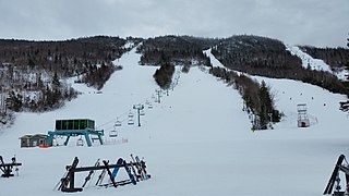
Camp Fortune is a commercial alpine ski centre located in the municipality of Chelsea in the Gatineau Hills north of Gatineau, Quebec, approximately fifteen minutes from Downtown Ottawa, Ontario.

The Lake Louise Ski Resort & Summer Gondola is a ski resort in western Canada, located in Banff National Park near the village of Lake Louise, Alberta. Located 57 km (35 mi) west of Banff, Lake Louise is one of three major ski resorts within Banff National Park.

The Powder Mountain Icefield, also called the Powder Mountain Icecap and the Cayley Icefield, is a glacial field in the Pacific Ranges of southwestern British Columbia, Canada, about 20 kilometres (12 mi) west of Whistler and about 90 kilometres (56 mi) north of Vancouver. On the west side of the icefield is the valley of the Squamish River, while on its east is the Callaghan Valley, which is the setting for the Nordic facilities for the 2010 Winter Olympics.

Baldy Mountain Resort is a family friendly ski resort overlooking the Okanagan Valley in southern British Columbia just north of the Washington state border. Its road access is via McKinney Road from Oliver and from BC Highway 33 north of Bridesville and BC Highway 3 west of Rock Creek, in the Boundary Country. Air access from Penticton Regional Airport. The summit is in the Okanagan Highland, an intermediary plateau-like area between the Monashee Mountains to the east and the Okanagan Valley immediately below to the west.

Calabogie Peaks is a ski resort in the municipality of Greater Madawaska, Renfrew County in Eastern Ontario, Canada. It is located 80 kilometres (50 mi) west of Ottawa, and was founded in 1969. Although the resort is named after the nearby community of Calabogie and Calabogie Lake, the mountain is called Dicksons Mountain. Calabogie Peaks Resort offers the highest vertical drop among public ski hills in Ontario, 238 metres (781 ft). In addition to the beginner hill, Calabogie offers the longest beginner trail in Ontario, as well as plenty of intermediate and expert runs.

Mont Ste. Marie is a privately owned ski resort 1 hour north of Ottawa in Lac-Sainte-Marie, Quebec, Canada. Between 1997 and 2002, Mont Ste. Marie was owned by Intrawest, a real estate development corporation, known for such places as Mont-Tremblant, Quebec, and Whistler Blackcomb, B.C.
Tabor Mountain Ski Resort, also known as Tabor Mountain Alpine Resort, is a ski resort located 20 km (12 mi) east of Prince George, British Columbia, Canada, adjacent to BC Hwy 16 on Mount Tabor.
Simpson Pass, el. 2,107 m (6,913 ft), is a mountain pass on the border between the Canadian provinces of Alberta and British Columbia, in the area of the Ball Range. It is the prominence col for Mount Ball on the Continental Divide in the vicinity of Sunshine Village ski resort. Simpson River and Simpson Pass are named after Sir George Simpson who first explored the area in 1841.
The Fitzsimmons Range is a small mountain range on the northwestern edge of the Garibaldi Ranges in southwestern British Columbia, Canada, located between the valleys of Cheakamus Lake (SW) and Fitzsimmons Creek (NE). Its most famous summit is Whistler Mountain, which overlooks the resort town of Whistler and is one of the two mountains forming the Whistler Blackcomb ski resort. Most of the range is within Garibaldi Provincial Park, while its northeastern extremity is part of the resort municipality, and of the lands associated with the ski resort operation. Other summits in the range include Oboe Summit, Piccolo Summit and Flute Summit, which are hillocks along the ridge running southeast from Whistler Mountain and were named in association with the renaming of Whistler. Beyond them is Singing Pass and Mount Fitzsimmons 2603 m (8540 ft) which is at the opposite end of the range from Whistler Mountain and the location of Fitzsimmons Glacier, which is the source of Fitzsimmons Creek.
Mount Musgrave is a mountain located in western Newfoundland, near the southern side of the Humber River valley at Steady Brook, approximately 7 km (4 mi) east of Corner Brook. The peak is named in honour of Sir Anthony Musgrave, a colonial governor of Newfoundland.
Ski Mont Saint-Bruno is a Canadian alpine ski facility. It is located on the slopes of Mont Saint-Bruno, in the city of Saint-Bruno-de-Montarville, Quebec. It is located right next to Parc national du Mont-Saint-Bruno, a Quebec provincial park that offers cross-country skiing and snowshoeing. The ski station is located on the South Shore of Montreal, 30 minutes from Downtown Montreal. The ski hill is 175m tall. It is also next to a quarry.

Mount Seymour Provincial Park is a park in Vancouver, British Columbia's North Shore Mountains. With an area of 35 square kilometres, it is located approximately 15 kilometres north of Downtown Vancouver. The park, named after Frederick Seymour, was established in 1936. Mount Seymour Provincial Park provides visitors with a variety of recreational activities and animals with natural habitat.


